


May 2 One More Hot Day Then The Cool Down And Rain For The Weekend
Thursday May 2 Morning Report This is one of those days where we get a little surprise. The old air mass is holding strong and will allow one more hot…
Wednesday February 16 2022
Night Report
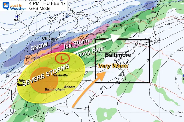
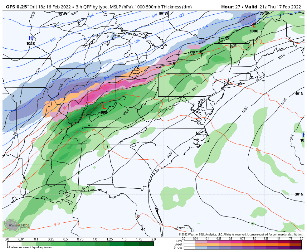
A major winter storm is developing across the US again. Perhaps the Full Moon is boosting the craziness, but this storm will have EVERYTHING and cover a large area. Perhaps since we’ve done plenty of snow and ice, the big story here will be the potential tornadoes.
It seems like a lot of the big ones stretch across the central US, staying to our west and keeping us on the warm side. But this will be a major snow and ice maker for The Great Lakes.
In the Deep South, an Enhanced Severe Storm Outbreak may produce damaging tornadoes and light up the storm chasers.
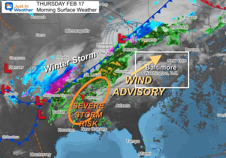
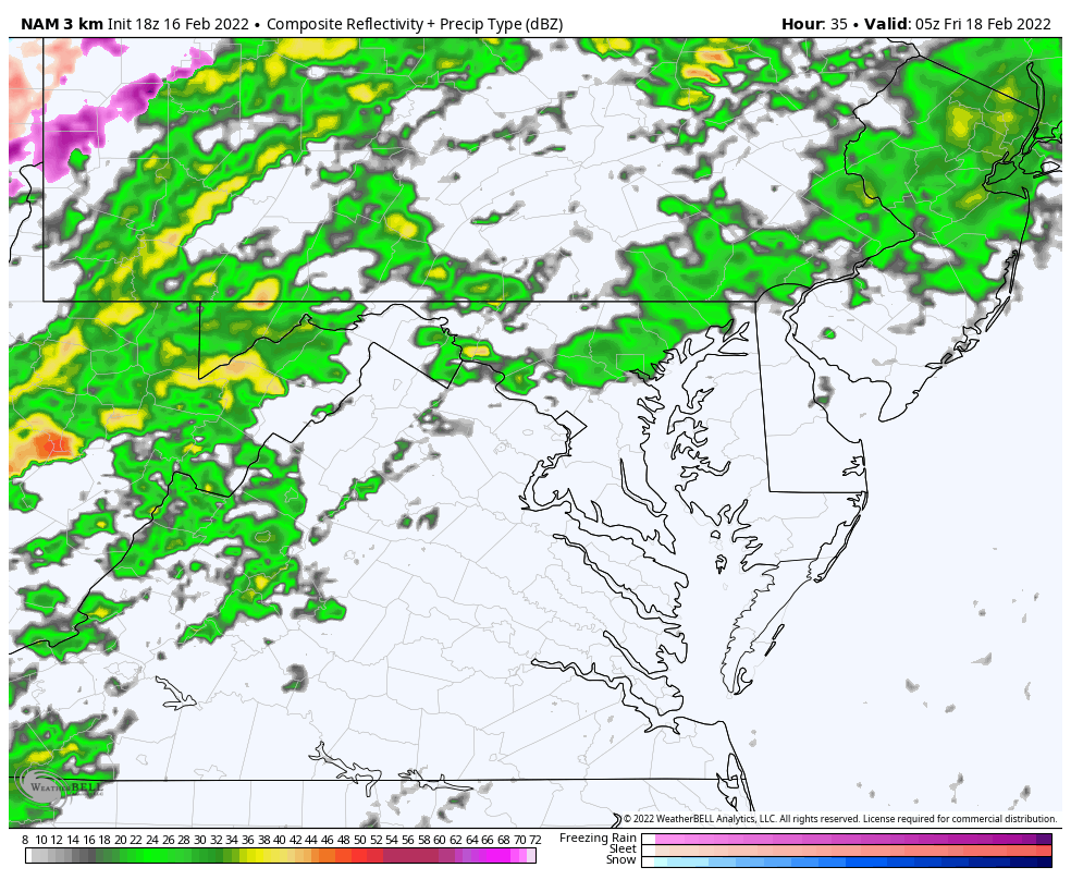
That system will weaken when it reaches us in the Mid Atlantic early Friday morning, but there my be enough energy left to produce some rumbles of thunder before sunrise.
I need to reiterate: Winter is taking a break, but it is NOT DONE for us yet! Another Polar Vortex disruption nay occur by the end of next week.
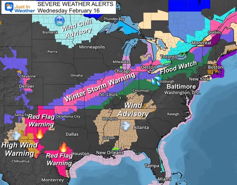
Winter Storm Warning and Wind Chill Advisories in the Northern US.
Flood Watch: Ohio Valley to Central NY as heavy rain will fall on melting snowpack.
Red Flag Warning/High Wind Warning: New Mexico and Texas. High winds on dry ground may enhance wild fire danger.
Wind Advisory: Dixie will have strong winds ahead of the severe storms (see below)
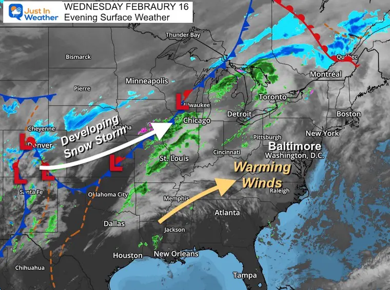
The main energy is near Denver with snow this evening. This will ride along the front to change rain to snow in places like Chicago.
The southern part of this complex will develop severe storms on Thursday.
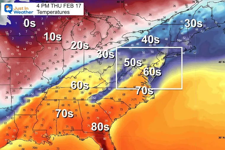
As this system develops, we will get in on the warming winds. So it will be breezy, but push temps into the upper 60s, and maybe some 70ºF readings in parts of Virgina or Southern Maryland.
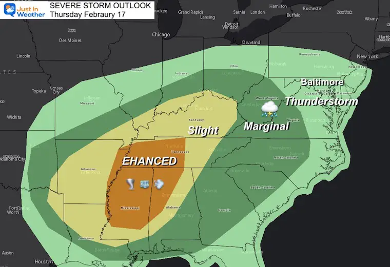
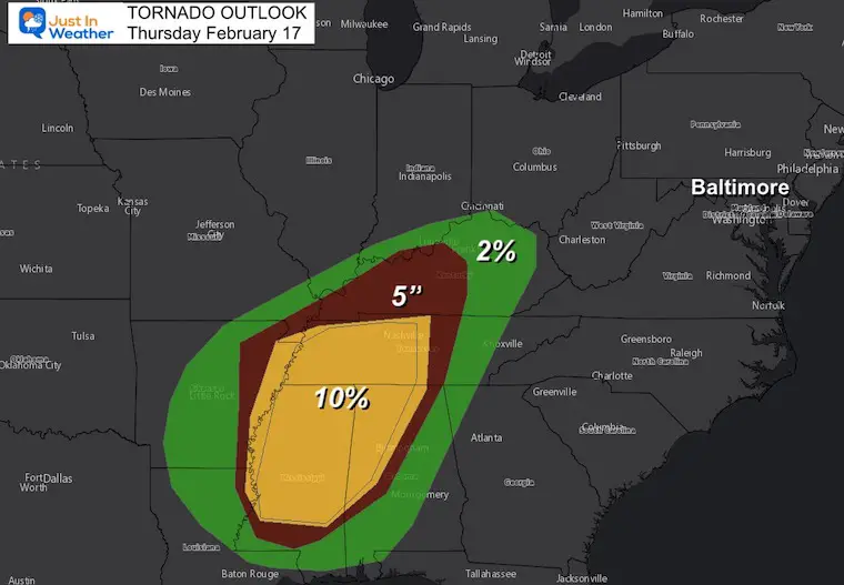
Enhanced Risk: Most of Mississippi, Northern Alabama, and Western Tennessee. This has the highest chance for tornadoes, large hail, and damming winds.
Slight Risk: Shaded in Yellow, this area may still get in on the severe storms, but the risk is lower.
Marginal Risk: This area shaded is green has the lowest risk in the severe zone due to timing of the event too late in the day, or closer to the cooler temps on the north side that don’t fully support the storms.
Thunderstorms: Baltimore and all of Maryland into Southern PA and Delaware are included with the chance for rumbles of thunder. This would be the remnants of the storms that fade overnight. A cold front will arrive before sunrise.
These are the odds and any particular storm will produce a funnel cloud that touches the ground. This will be highest in the Enhanced Outlook Region.
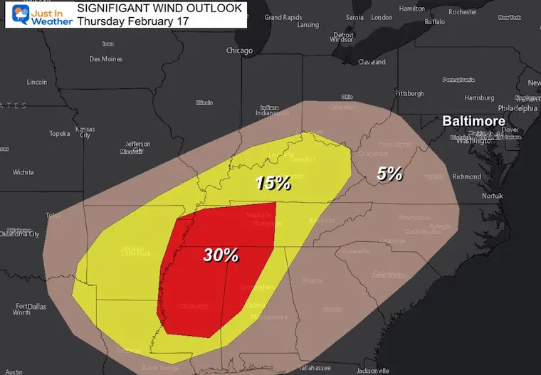
This is for the chances of damaging winds over 60 mph.
This is the forecast set up at 4 PM
The snow and ice will expand nearly 1000 miles to the North, while severe storms erupt in the South.
We will get warming winds that push temps into the upper 60s. Since models tend to underestimate warm air, I think there is a chance for some spots close to 70ºF in souther Maryland and Virginia.
4 PM Thu to 4 PM Fri
Friday Midnight to 12 Noon
3 AM to 6 AM: The front may cross metro Baltimore between
That is the window for much of our region to maybe hear thunder.
6 AM and 8 AM
The front will cross south Annapolis/Bay Bridge to Ocean City.
After chilly air this weekend, next week will turn mild again.
WINTER IS NOT DONE YET!
There is an old adage in Weather Folklore I’ve written about before that may relate.
It states:
Our Arctic Research Friend Dr. Judah Cohen has been discussing anther Polar Vortex disruption by the end of the month. This is that type of event that can send arctic air back our way.
Last night’s #PolarVortex (PV) animation was the most entertaining in a while (& the sole motivation for my post) suggesting a split. Though it is an outlier model run with little support from the ensembles, the tropospheric pattern is looking more favorable for disrupting the PV pic.twitter.com/JKrGi3zGB0
— Judah Cohen (@judah47) February 16, 2022
The PNA is heading back towards POSITIVE
And
MJO in Phase 3
Together they also support colder air returning to the Eastern US.
Stay tuned, and Faith in the Flakes.


Last Winter Recap: My Old Outlook And Your Grades Of My Storm Forecasts


*Disclaimer due to frequent questions:
I am aware there are some spelling and grammar typos. I have made a few public statements over the years, but if you are new here you may have missed it:
I have dyslexia, and found out at my second year at Cornell. I didn’t stop me from getting my meteorology degree, and being first to get the AMS CBM in the Baltimore/Washington region.
I do miss my mistakes in my own proofreading. The autocorrect spell check on my computer sometimes does an injustice to make it worse.
All of the maps and information are accurate. The ‘wordy’ stuff can get sticky.
There is no editor that can check my work when I need it and have it ready to send out in a newsworthy timeline.
I accept this and perhaps proves what you read is really from me…
It’s part of my charm.
#FITF