Conditions: Baltimore, Maryland, 05/10/2024 01:30:04 am
Temperature

58°

Cloudy with Rain

54°

Dew Point
Relative Humidity

87%

Feels Like

58°

Wind (ENE)

10mph

Air Pressure

29.65

Sun
Sun Rise

05:57 AM

Sun Set

08:08 PM

Day Length

14:11 Hours

Difference

1 min 58 sec gain

Moon
Moon Rise

07:30 AM

Moon Set

11:34 PM

Next: First Quarter

May 15,2024

Moon Phase

Waxing Crescent

Climate
Average Low

50°

72°

Average High
Record Low

33°


(1983)

96°


(1896)
Record High
Conditions

Thursday Arctic Front Brings Snow Burst Then Friday Night Possible Coastal Storm

Frost and Freeze
Storm Forecast
Winter Weather
Forecast

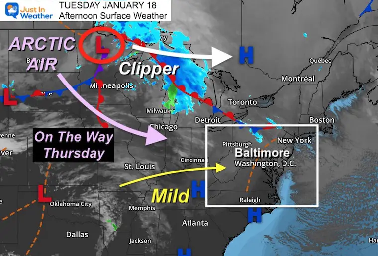
Tuesday January 18 2022 

Afternoon update

This very active winter weather pattern is about to bring us to more events this week.  I know there is a lot of buzz about a possible coastal storm to start the weekend, but I would like to focus on the more impending event Thursday morning.

The front that will bring back arctic air will arrive with rain, turning to a burst of snow. There will be enough moisture to produce a couple of inches of snow. 

The timing will be during the Thursday morning commute as temps are dropping. So there is added potential of negative impact form slush and icing on school and work travel. 

The National Weather Service is likely to issue a Winter Weather Advisories late tonight or tomorrow morning for this event. That is planned 24 to 36 hours ahead of time to prepare.

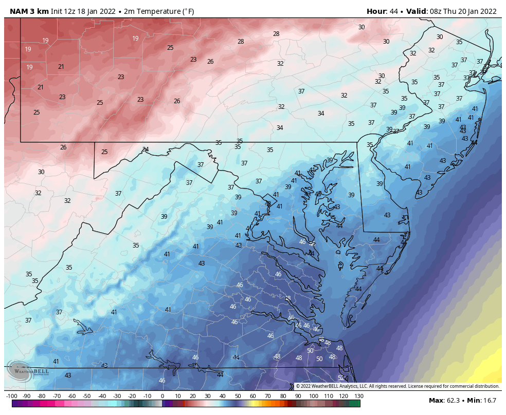
Let’s take a closer look at the timing of the temp drop AND the rain/snow burst.  


Tuesday Afternoon Set Up

We are in a mild air mass today and tomorrow. But we have to watch that Clipper along the US Canadian border.  That itself will not reach us, but it will allow the arctic air to get pulled down behind it and head our way for daybreak on Thursday.


Thursday Weather:

Temperature Forecast Animation

3 AM to 7 PM

Metro areas will start close to 40ºF then drop to freezing after the snow begins.  There will be stickage and icing on the roads after sunrise.

January-18-weather-temperatures-thursday-morning


Key Timeframes

This mini-slider shows the progress of the Freezing Line.

Compare to the snow slider below, for the changeover.  These temps will lag behind the snow, so timing stickage and icing will be a big problem to solve. 
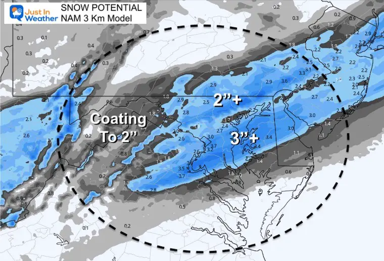
 

january-18-weather-forecast-temperatures-thursday-am-5
january-18-weather-forecast-temperatures-thursday-am-9
january-18-weather-forecast-temperatures-thursday-pm-1
previous arrow
next arrow
january-18-weather-forecast-temperatures-thursday-am-5
january-18-weather-forecast-temperatures-thursday-am-9
january-18-weather-forecast-temperatures-thursday-pm-1
previous arrow
next arrow


Radar Simulation —> slider

3 AM to 4 PM


january-18-weather-snow-radar-thursday-am-3
january-18-weather-snow-radar-thursday-am-4
january-18-weather-snow-radar-thursday-am-5
january-18-weather-snow-radar-thursday-am-6
january-18-weather-snow-radar-thursday-am-7
january-18-weather-snow-radar-thursday-am-8
january-18-weather-snow-radar-thursday-am-9
january-18-weather-snow-radar-thursday-am-10
january-18-weather-snow-radar-thursday-am-11
january-18-weather-snow-radar-thursday-pm-12
january-18-weather-snow-radar-thursday-pm-1
january-18-weather-snow-radar-thursday-pm-2
january-18-weather-snow-radar-thursday-pm-3
january-18-weather-snow-radar-thursday-pm-4
previous arrow
next arrow


How much Snow?

Please note this is the NAM forecast, not mine. I am showing you because I think the general expectation of 1 to 3 inches is a good starting point. 


Friday Morning Temperatures 

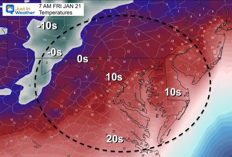
Here’s a look at the arctic air that will follow. Much of Maryland will be in the teens (10s).  Notice the air mass logging below zero numbers farther west. This is another deep air mass.


Friday Night/Saturday Morning

No rest for the weary. Low Pressure will rapidly develop along this arctic front and around the base of this trough. 

The model guidance is not is full agreement, but which is why I do not want to put too much emphasis on this right now.


KEY NOTE:

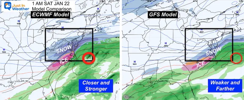
There has been a tendency for storms to verify a little farther west.  We saw this trend and validation with our last event.  So, which this is on the edge or out of reach for some in our region,  I do believe we will end up seeing this heavy snow shield shift back west a little. So impact on the big cities and suburbs is still worth watching.

Plan for some impact through Saturday. I will explore more on this later.

I understand there is a lot of chatter, and you may have seen reports of (epic or historic) snow now being pulled back. This is why I hold off on big calls until I feel there is a good grip of the set up.  This arctic front still has to do its thing.


Weather posts straight to your inbox

Sign up and be the first to know!


ALSO SEE


What is Faith in the Flakes: History of December 5th Snow


ALL FITF GEAR


FITF THUNDERSNOW


Winter Outlook Series:

My Call For Snowfall


Last Winter Recap: My Old Outlook And Your Grades Of My Storm Forecasts

Winter Weather Page – Lots of resources


Solar Cycle Increasing Sunspots Suggests More Snow


Comparing 4 Different Farmer’s Almanacs: Majority colder winter outlook than NOAA


NOAA Winter Outlook- But Read The Fine Print


Signals For Early Start To Winter In November


Winter Outlook Series: La Nina Double Dip


Nor’easters May Give Hint For Winter La Nina Pattern


Winter Folklore Checklist


Please share your thoughts, best weather pics/video, or just keep in touch via social media

Facebook: Justin Berk, Meteorologist

Twitter: @JustinWeather

Instagram: justinweather