Thursday January 27 2022
Evening Update
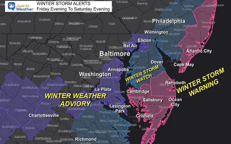
This is really going to be a tight gradient for snow slicing through our region. The Chesapeake Bay is going to serve as the edge of the impact snow, with much more farther east. Due to the strong winds over 40 mph and cold temps, snow will be blowing around, lowering visibility. Blizzard conditions may verify Saturday morning.
Light snow will develop inland during the day on Friday. However the biggest impact will be overnight and into Saturday morning.
A Winter Storm Warning is in place for the coastal areas. I have a closer look at the beach snow outlook.
A Winter Weather Advisory has been issued for the counties just on the western edge of The Bay.
Farther inland, less snow is expected, but winds will be gusty on Saturday as well. This is when we may revive the term Flurricane, which I remember form a similar storm about 10 years ago.
NEW UPDATE FRIDAY MORNING
Older Report…
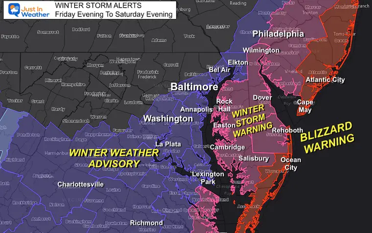
Winter Storm Warning AND Winter Weather Advisory
FROM NWS
Pink: Winter Storm Warning
- Maryland’s Lower Easter Shore: 5 to 10 inches of snow; Winds to 45 mph
- Delaware’s Sussex County and coastal New Jersey:
- Snow 9 to 15 inches, Winds to 50 mph
Purple: Winter Weather Advisory
- Maryland: West of the Bay. Cecil, Harford, (Baltimore is now included), Anne Arundel, Calvert, Prince Georges, Charles, and St. Mary’s.
- Snow: 1 to 3 inches, Winds to 40 mph
Light Blue: Winter Storm ‘Watch’ remains.
- This is due to being on the edge of criteria that is still uncertain (more or less snow). So the upgrade can go either way as the storm track is narrowed.
- This includes Upper Eastern Shore and Northern Delaware between Easton to Wilmington and metro Philadelphia.
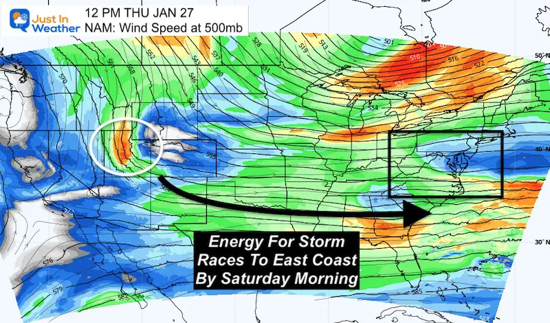
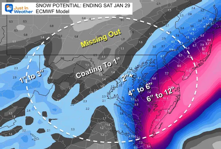
Storm Potential
My snow numbers were posted earlier in my afternoon report. Below I will compare them to the National Weather Service. Mine are a little lower for the ‘Thump’ Zone. It looks like NWS is following the ECMWF Numbers for the coast.
So let’s review that model plot…
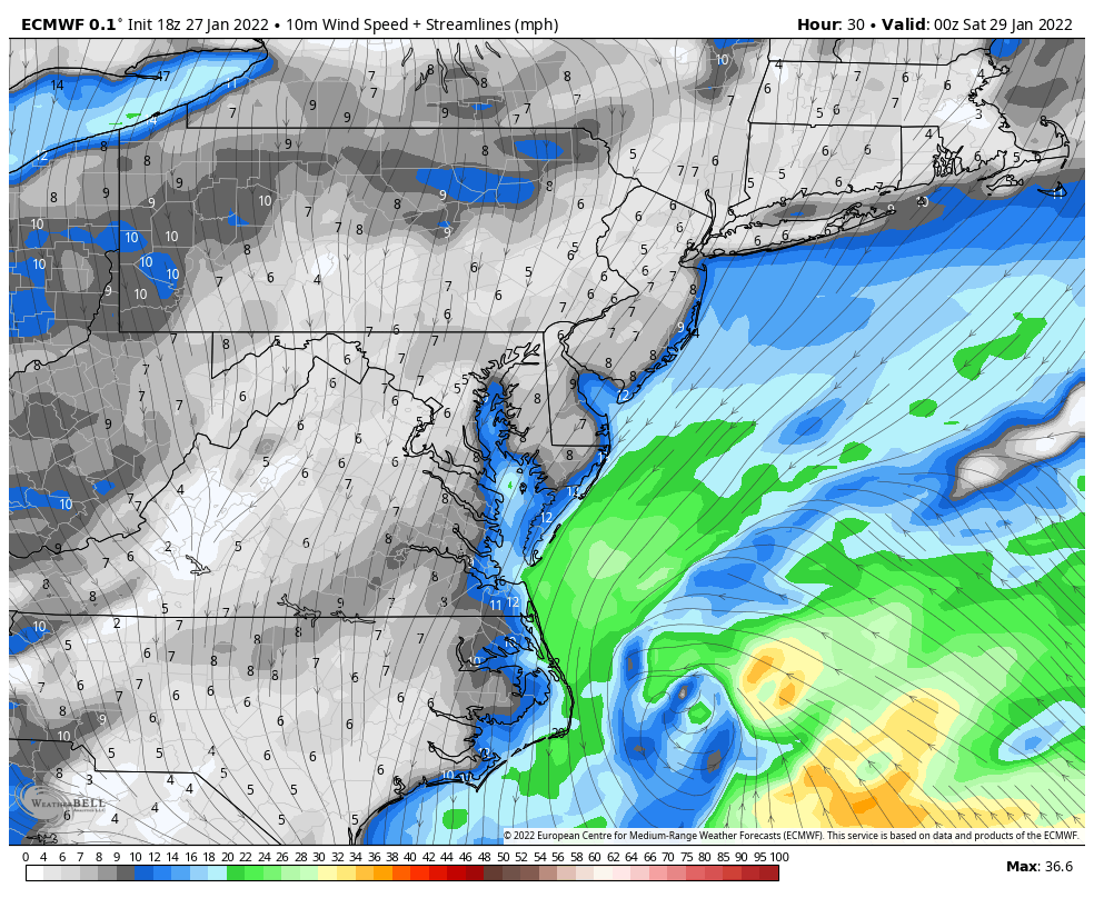
Storm Plot: European Model
Saturday Morning
This keeps Baltimore in the light snow at 4 AM. Annapolis and the Bay split the steady to heavy snow east and south.
There will be a cutoff that biomes more pronounced by daybreak.
Explore More:
Click here to see how the storm is developing and the NAM 3 Km snow timeline
Wind Animation: Fri 7 PM to Sat 12 PM
- The numbers may be hard to read but the development is the important part.
- The winds will increase early Saturday Morning as the storm passes by and north of our coastlines.
- Gusts between 7 AM and 12 PM Saturday may reach 40 to 50 mph between The Bay and The Ocean Shorelines.
Blizzard?
A true blizzard is considered when winds are 35 mph or higher along with snow at 1″/Hr or more for three consecutive hours.
It may qualify along the coast around sunrise.
How Much Snow? Let’s Look at it ALL!
First: My Call For Snowfall
- I played it conservative considering the initial dry air and nod to the American Models tracking just a little farther east.
- Any BUST would be if the European Model wins, and we get more farther west.
- There will be a sharp cutoff just west of the Bay. If you want to brave driving over the Bridge on Saturday afternoon, there will be much more on the Queen Anne’s side.
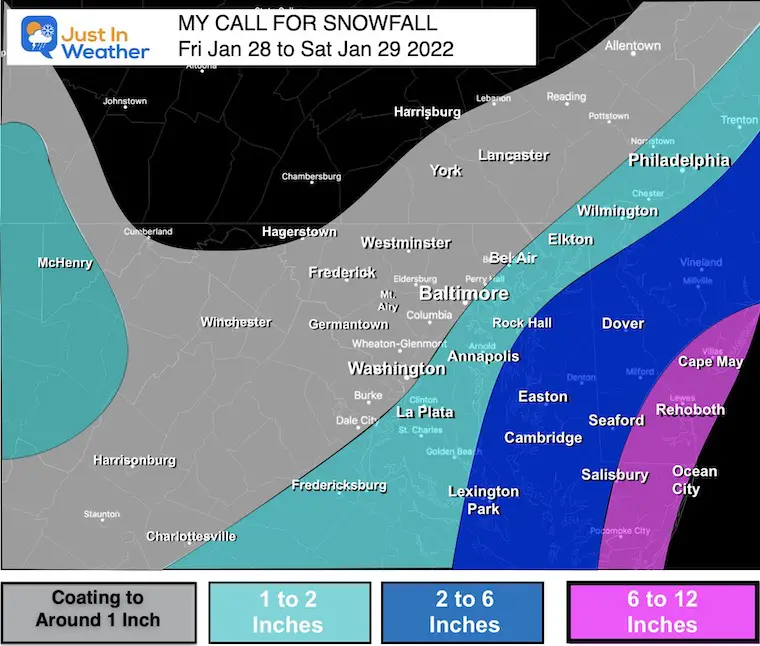
Quick Summary:
Metro Baltimore in the dusting to 2 inches. Less west, more near The Bay.
Along the Bay between Annapolis to Havre de Grace and Elkton and up I-95 to Wilmington and Philadelphia between 1 and 2 inches.
More Snow- Wider Range 2 to 6 inches
Due to the sharp gradient, I had to make this wide range which clips St. Mary’s County (Lexington Park) and over to the Eastern Shore.
Big Winner: 6 to 12 inches
A Winter Storm Warning was just upgraded for this area. I will have an update on that shortly. This area will be in the thick of heavy snow and wind Saturday morning at daybreak. From close to Salisbury to along the coastal region of Maryland to Delaware is where the most snow will pile up. It will be cold enough for maximum stickage, but the wind will blow it around a lot.
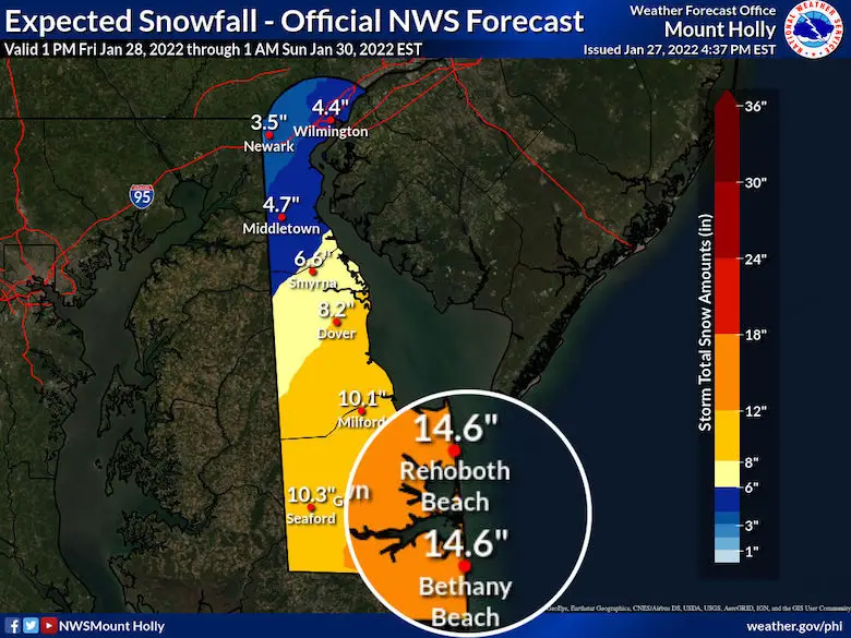
National Weather Service Snow Maps
I enhanced the numbers along the immediate coast. If you want to see ALL the snow maps, click here for my NWS Snow and Ice Page
Maryland’s Coast:
- 8” to 12” for Ocean City.
- Also note the Sharp Cutoff just west of the Bay.

Delaware:
(See, I am giving you all the love now)
- Bethany and Rehoboth both being plotted By NWS with 14.6”
New Jersey:
The 12” to 14” extends up to Atlantic City and Asbury Park.
Look west with less than half of that in metro Philadelphia.

Computer Model Snow Maps
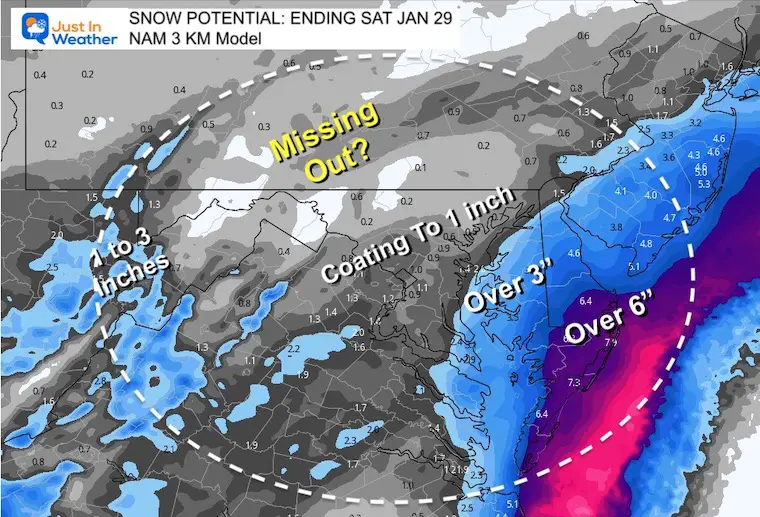
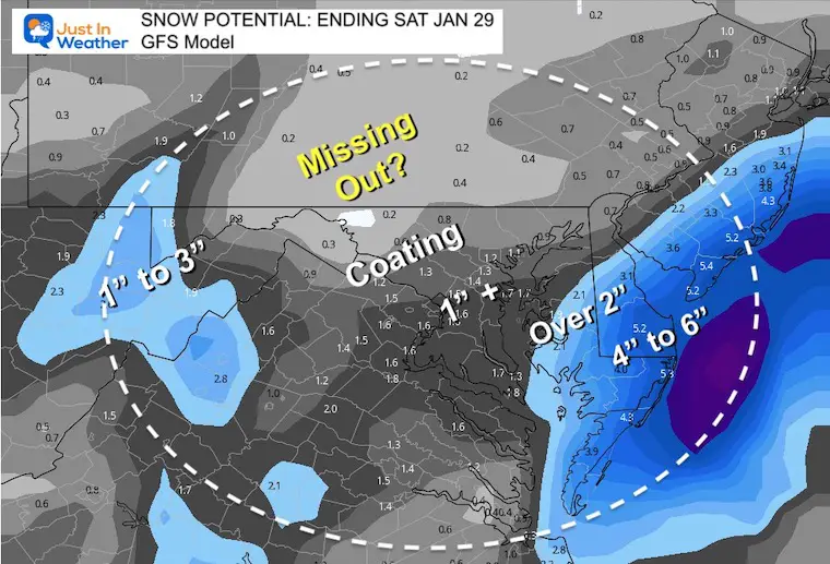
Comparing theses three models, we can see the European has the most snow, the GFS has the least. The High Resolution NAM 3Km is the middle of the pack and that is what I am leaning towards.
I hope this helps explain why you may have seen many different forecasts for your area. There is a wide spread and each meteorologist or your weather ap may prefer one over another for various reasons.
European Model Snow
NAM 3 Km Snow
GFS Snow
My next report will be Friday morning. Then we can spend the day tracking the initial snow and then the coastal forming at night.
Faith in the Flakes.
*Disclaimer due to frequent questions:
I am aware there are some spelling and grammar typos. I have made a few public statements over the years, but if you are new here you may have missed it:
I have dyslexia, and found out at my second year at Cornell. I didn’t stop me from getting my meteorology degree, and being first to get the AMS CBM in the Baltimore/Washington region.
I do miss my mistakes in my own proofreading. The autocorrect spell check on my computer sometimes does an injustice to make it worse.
All of the maps and information are accurate. The ‘wordy’ stuff can get sticky.
There is no editor that can check my work when I need it and have it ready to send out in a newsworthy timeline.
I accept this and perhaps proves what you read is really from me…
It’s part of my charm.
#FITF
ALSO SEE
ALL FITF GEAR

FITF THUNDERSNOW


Winter Outlook Series:
My Call For Snowfall

Last Winter Recap: My Old Outlook And Your Grades Of My Storm Forecasts


Please share your thoughts, best weather pics/video, or just keep in touch via social media


