


May 12 Mothers Day Showers And Another Aurora Viewing Tonight May Be Better
Sunday May 12 Mother's Day Morning Report Today, we focus on the all-important Mother’s Day weather and the ongoing impact of the latest Solar Storm. We have been stuck in…
Thursday January 27 2022
Afternoon Report
This is a brief update since I am behind schedule to post My First Call For Snowfall. If you have read my prior reports, I have been hedging my bets on a sharp cutoff line, with a big bump higher on the Eastern Shore and less farther west.
The latest model guidance supports that sharp cutoff line near or just east of Baltimore and I-95.
This reminds me of a storm about 10 years ago that was dubbed a ‘Flurricane’ due to the winds and light snow. If you want more snow, you might want to root on the European Model. The ECMWF is still pulling the storm west with more impact in the cities. The showdown is on, but I must tip my hat to the American Models, meaning less snow. If I am wrong and we bust, it would be on the up side.
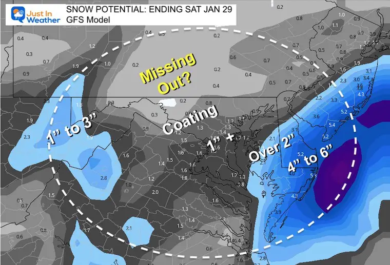
Just the snapshots for the closest brush with the Coastal Storm on Saturday morning.
Click here to see my prior report for closer full timeline.
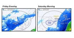
Note: Light snow will develop Friday Most of what we get will be Friday evening and night.
The coastal will dump on Delmarva through daybreak Saturday. The storm should move away from our region by the afternoon. Then strong cold winds prevail.
Models AGREE on big storm impact on the coast and interior Delmarva. It might seem like a disappointment in metro Baltimore, but this is why I was holding out. It just didn’t feel like our storm matching some of the crazy maps that went viral on social media. Again, if I am wrong, it would be the European Model shown below that wins on the upside.
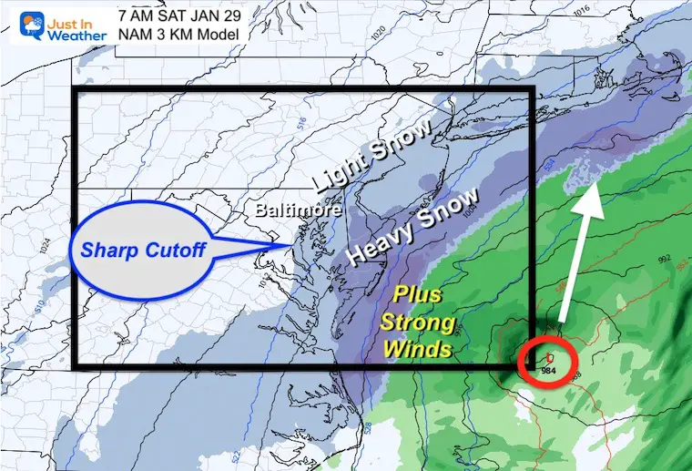
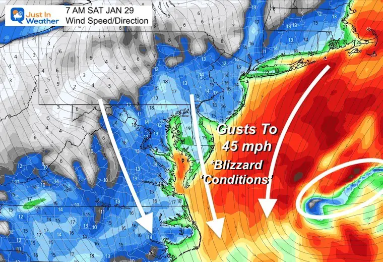
Saturday Morning
This keeps Baltimore in the light snow at 4 AM. Annapolis and the Bay split the steady to heavy snow east ad south.
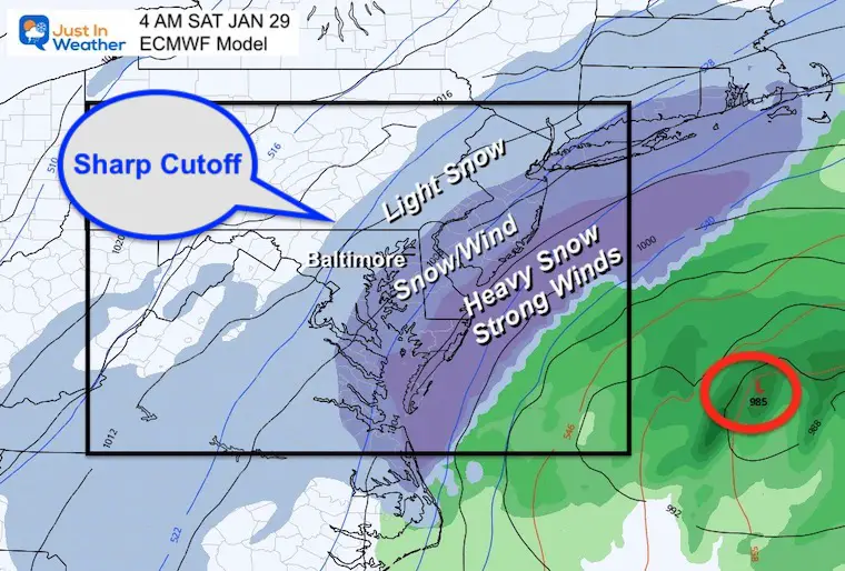
This is at 7 AM where we see the closest brush with the coastal. The back edge of the light snow lines up where the back of the steady snow on the Euro. This shifts everything about 50 miles east of the Euro.
Also at 7 AM, here we see the back edge of the light snow even farther east.
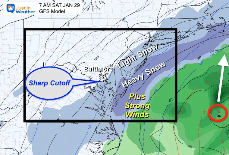
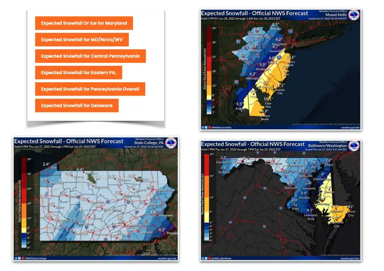
Comparing theses three models, we can see the European has the most snow, the GFS has the least. The High Resolution NAM 3Km is the middle of the pack and that is what I am leaning towards.
I intend for very little adjustment from this with any update. However, at this point the likelihood of heavy now on Delmarva is pretty solid.
Any BUST would be if the European Model wins, and we get more farther west.
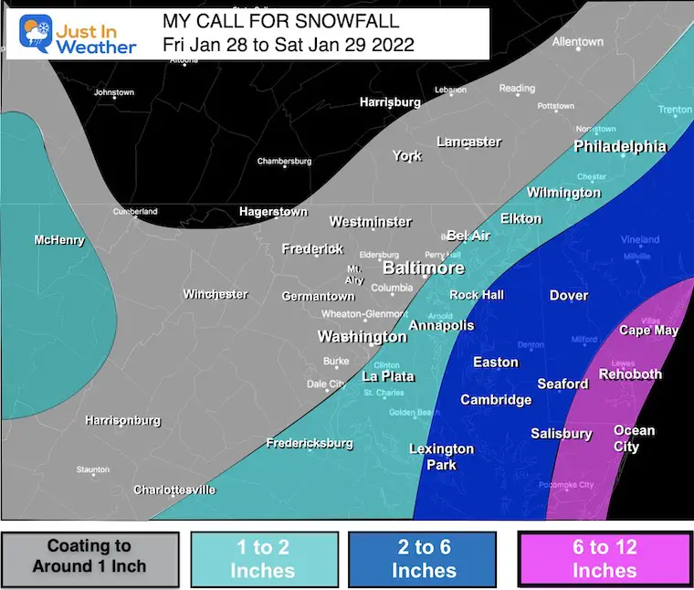
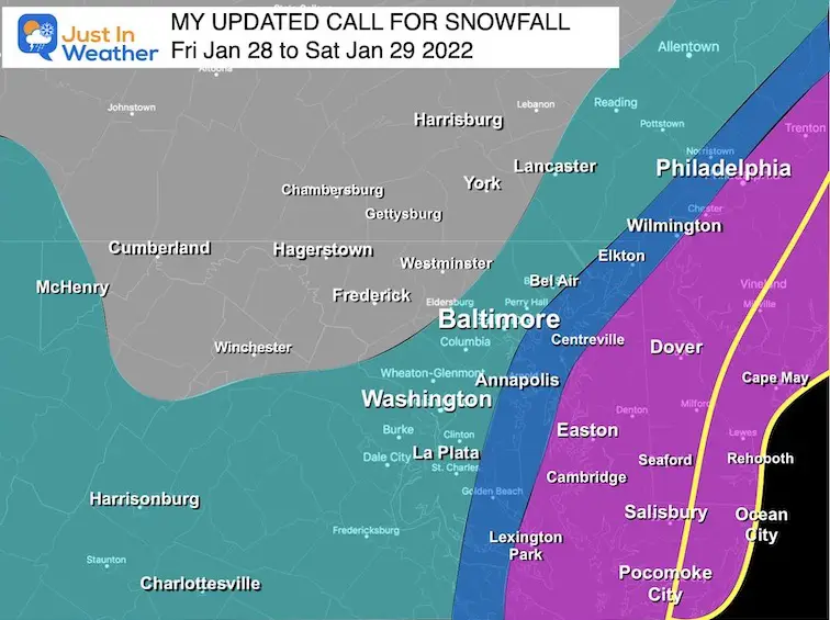
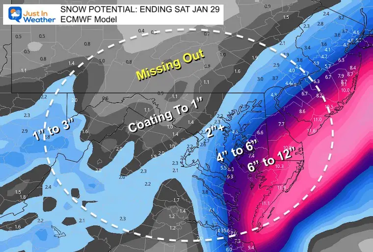
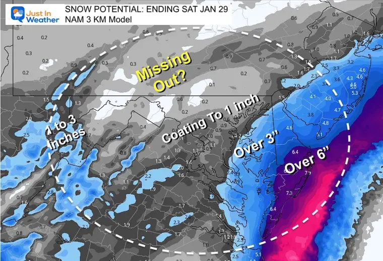
Metro Baltimore in the dusting to 2 inches. Less west, more near The Bay.
Along the Bay between Annapolis to Havre de Grace and Elkton and up I-95 to Wilmington and Philadelphia between 1 and 2 inches.
More Snow- Wider Range 2 to 6 inches
Due to the sharp gradient, I had to make this wide range which clips St. Mary’s County (Lexington Park) and over to the Eastern Shore.
Big Winner: 6 to 12 inches
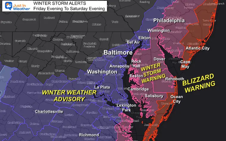
A Winter Storm Warning was just upgraded for this area. I will have an update on that shortly. This area will be in the thick of heavy snow and wind Saturday morning at daybreak. From close to Salisbury to along the coastal region of Maryland to Delaware is where the most snow will pile up. It will be cold enough for maximum stickage, but the wind will blow it around a lot.
See Maryland, Delaware, New Jersey, Pennsylvania, and northern Virginia/West Virginia
Click here to see all region NWS Snow maps
Next Up: A look at the Euro and I will work on my snow map as well.
Faith in the Flakes.
*Disclaimer due to frequent questions:
I am aware there are some spelling and grammar typos. I have made a few public statements over the years, but if you are new here you may have missed it:
I have dyslexia, and found out at my second year at Cornell. I didn’t stop me from getting my meteorology degree, and being first to get the AMS CBM in the Baltimore/Washington region.
I do miss my mistakes in my own proofreading. The autocorrect spell check on my computer sometimes does an injustice to make it worse.
All of the maps and information are accurate. The ‘wordy’ stuff can get sticky.
There is no editor that can check my work when I need it and have it ready to send out in a newsworthy timeline.
I accept this and perhaps proves what you read is really from me…
It’s part of my charm.
#FITF


Last Winter Recap: My Old Outlook And Your Grades Of My Storm Forecasts


