


May 17 Clouding Up Ahead Of A Soggy Preakness Saturday Then We Warm Up
Friday May 17 Morning Report Today may end up mild, but it will bring an increase in clouds ahead of our next storm. If you are heading to the mountains,…
February 8, 2024
Thursday Morning Update
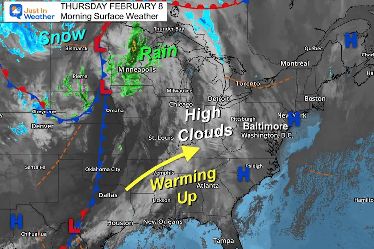
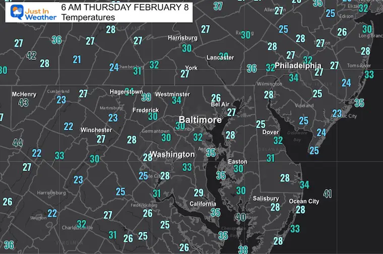
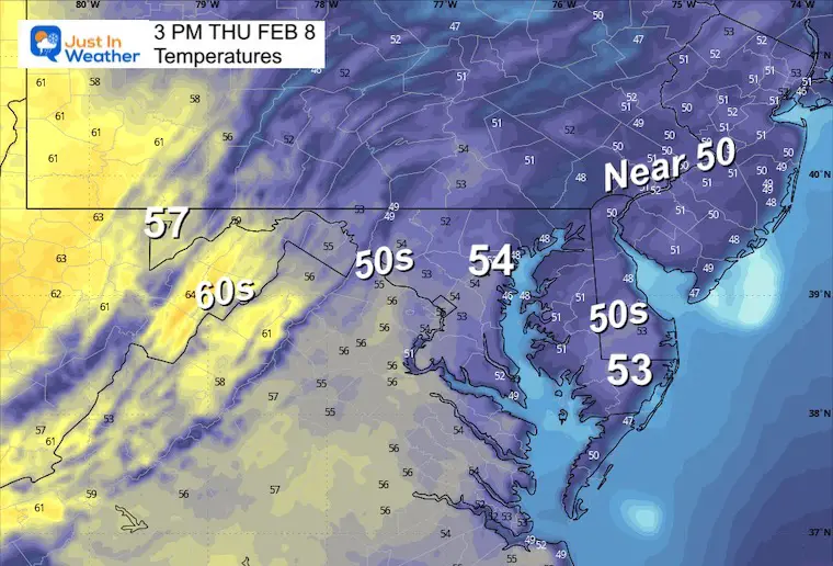
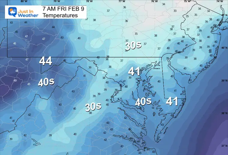
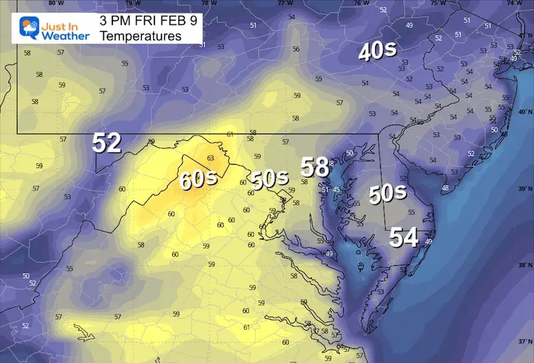
Today, we will see more high clouds mix in across the sky. This is a signal of the shifting weather pattern that will allow warmer air to flow in for a few days. This will also allow a few days of rain.
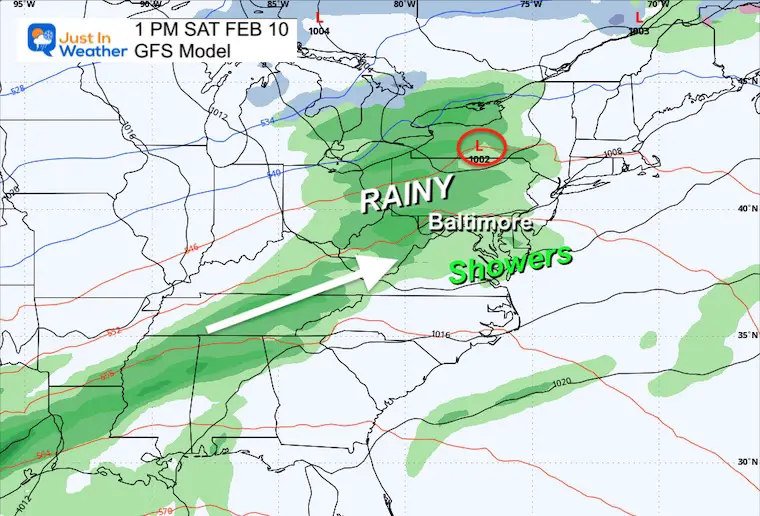
As of now, the weekend does appear to bring in rain showers on Saturday, and then the focus of rain on Sunday will be in Southern Maryland and southward.
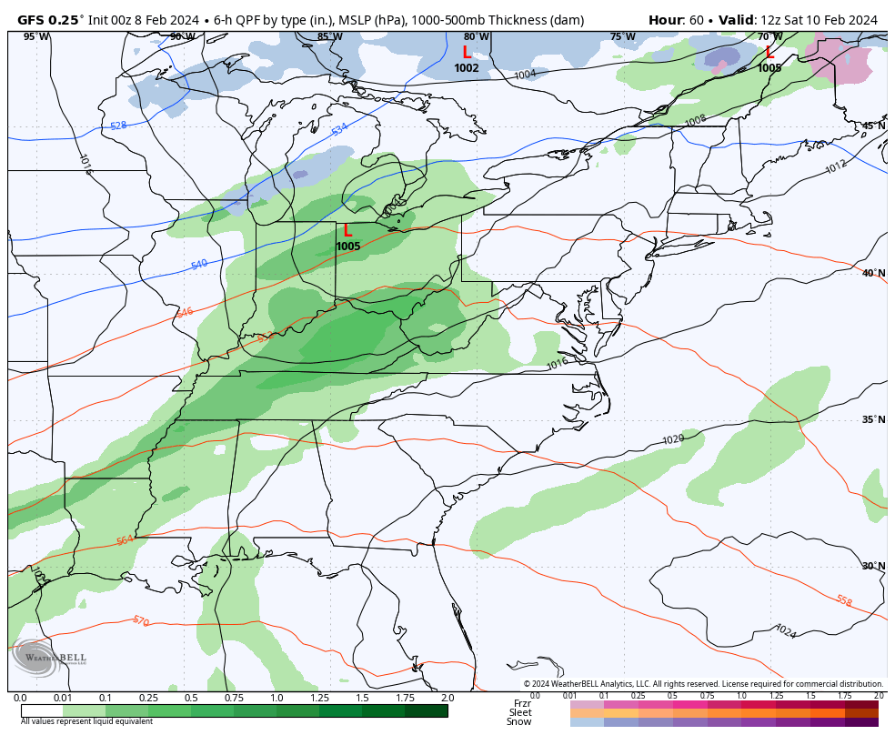
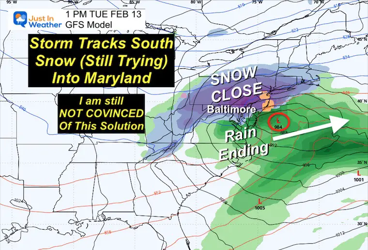
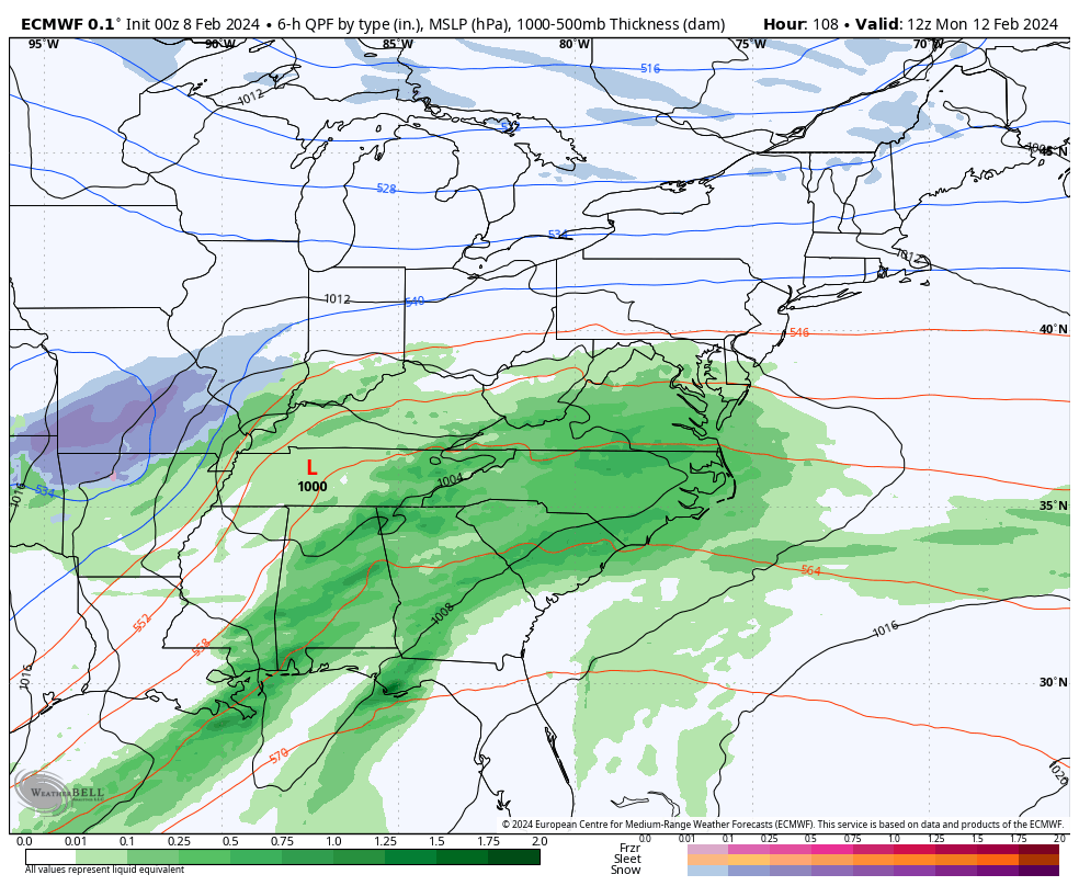
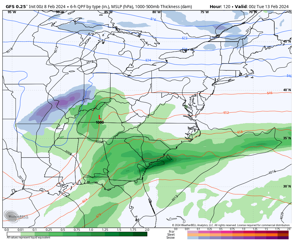
Another storm that follows will mark the adjustment back to a winter pattern. However, the actual impact is split. The GFS Model is still trying (very hard) to produce snow, while the European Model may be more realistic with snow as the pre-Valentines Day storm tracks North.
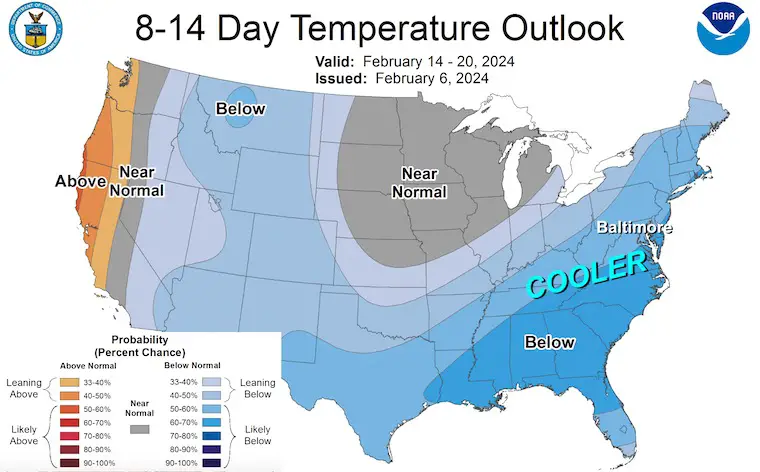
High Pressure is lined up across the Eastern US. As this shifts east, it allows the high clouds and wind flow from the Southwest to bring in warmer air. The storm track will be mild, but colder air will flow after it passes and settle in for the middle of the month.
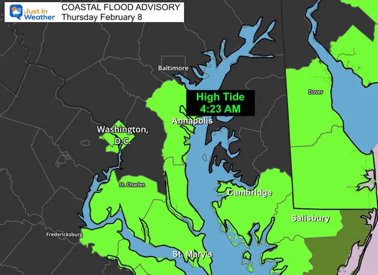
Water Levels may produce flooding for the Annapolis Docks through Friday. The high water may also produce light to moderate flooding across Southern Maryland and parts of the Lower Eastern Shore.
Sunrise at 7:07 AM
Sunset at 5:35 PM
Normal Low in Baltimore: 26ºF
Record -1ºF in 1967
Normal High in Baltimore: 45ºF
Record 72ºF 2017
SEASONAL SNOW at BWI
9.1 inches
Click here for the maps and full report
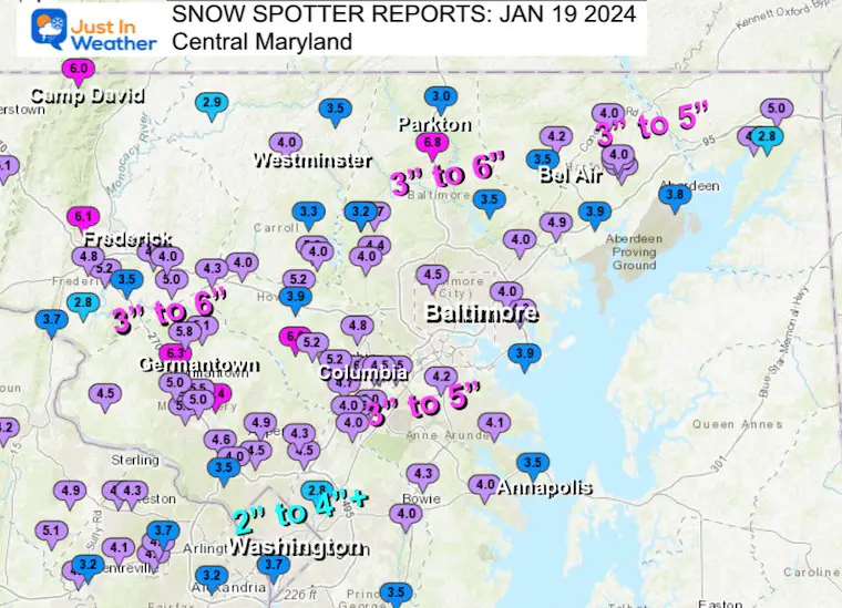
Click here or the map to see: The Snow Report Ending Jan 16

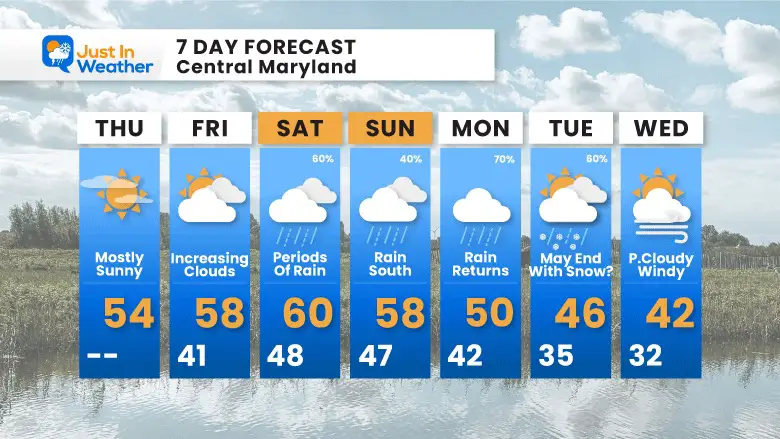
Rain may be steady and unfortunate for the mountains on Saturday. Showers will spread east during the day. It will not be a washout in the population center/cities and suburbs, but we can expect periods of rain.
Sunday, the steady rain is likely to focus from Southern Maryland and southward. This may include Salisbury to Virginia Beach.
THE PATTERN WILL CHANGE WITH THIS STORM
THE ACTUAL STORM IS STILL UNCERTAIN
I continue to not trust the modeling, even now, within 5 days. Here we see the European Model with a track of this storm to our north… keeping the Snow in the mountains up to New England.
The GFS Model is still trying persistently to show snow into Maryland with a track farther south.
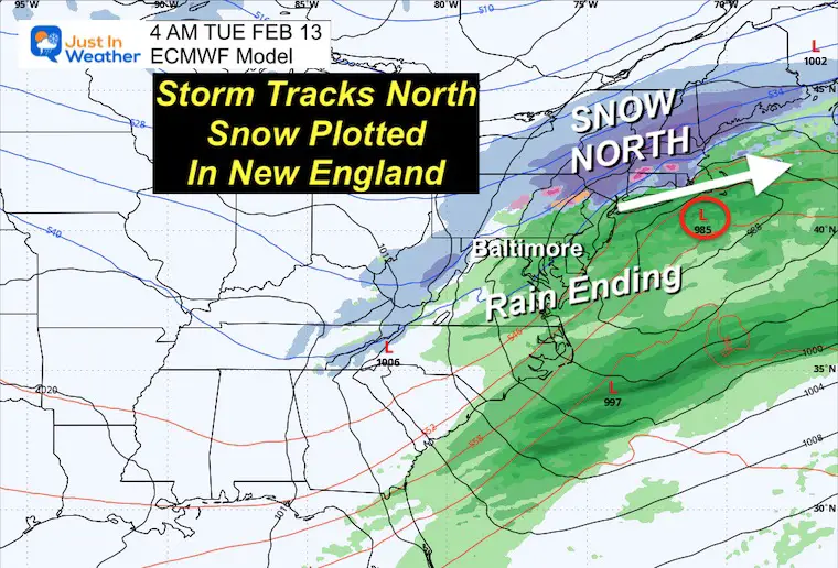
I am leaning towards the European idea, however, a hybrid solution would allow for a shift south and maybe an end with snow in our northern suburbs. Temps will be too warm, so I do not anticipate an impact.
This is more acceptable (for now).
This is more wishful thinking… but it keeps showing snow for us. I will dig deeper into the data to explore it for my next report.
On Tuesday night, I wrote this report explaining the pattern change. Click this map or here for more…
Temperatures will be warming ahead of the weekend weather event. This storm may bring the best ‘chance’ for rain on Saturday, then shift south on Sunday.
The return of colder air will arrive with the next storm on Monday. Rain may end with a mix of snow inland… then flurries to follow.

Click to see more and ‘Book’ a visit to your school


Computer Models Support East Coast Storm Track

The latest NOAA report is confident in a Very Strong event. Possibly HISTORIC! This refers to the temperatures in the Pacific, with impacts on the US Winter Storm Track.

Winter Weather Folklore: Top 20 and more signals from nature for snow.
Winter Outlook 2024 From Two Farmers Almanacs Return to Cold and Snow
I am aware there are some spelling and grammar typos and occasional other glitches. I take responsibility for my mistakes and even the computer glitches I may miss. I have made a few public statements over the years, but if you are new here, you may have missed it: I have dyslexia and found out during my second year at Cornell University. It didn’t stop me from getting my meteorology degree and being the first to get the AMS CBM in the Baltimore/Washington region. One of my professors told me that I had made it that far without knowing and to not let it be a crutch going forward. That was Mark Wysocki, and he was absolutely correct! I do miss my mistakes in my own proofreading. The autocorrect spell check on my computer sometimes does an injustice to make it worse. I also can make mistakes in forecasting. No one is perfect at predicting the future. All of the maps and information are accurate. The ‘wordy’ stuff can get sticky. There has been no editor who can check my work when I need it and have it ready to send out in a newsworthy timeline. Barbara Werner is a member of the web team that helps me maintain this site. She has taken it upon herself to edit typos when she is available. That could be AFTER you read this. I accept this and perhaps proves what you read is really from me… It’s part of my charm. #FITF