


May 1 Weather Gradual Cooling Trend Will Bring Rain Into The Weekend
Wednesday, May 1 Morning Report One of the marks of May Day is an ancient European holiday celebrating the start of summer. It feels like we have had our taste…
Saturday January 20 2024
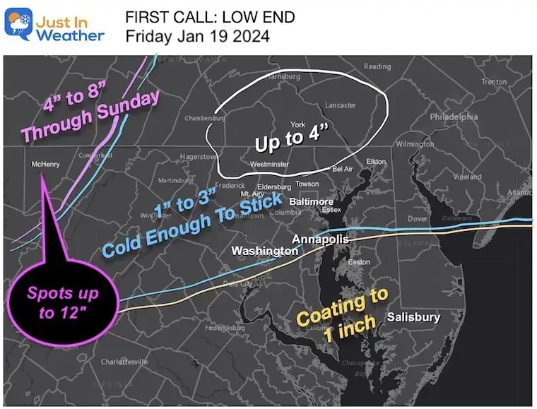
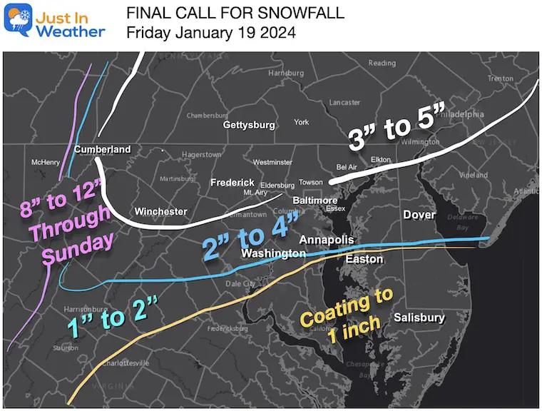
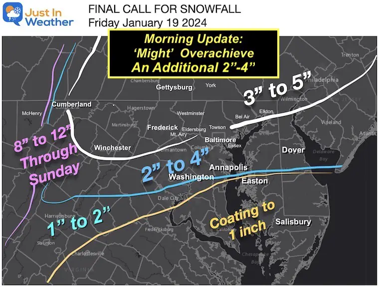
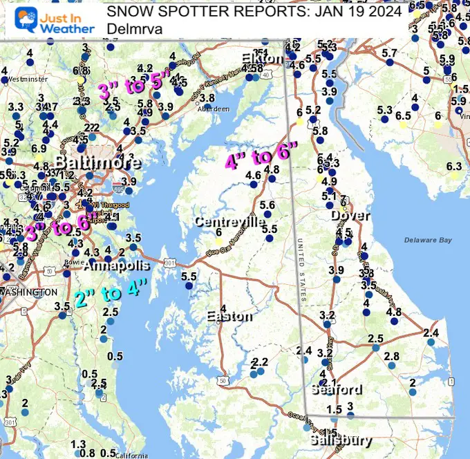
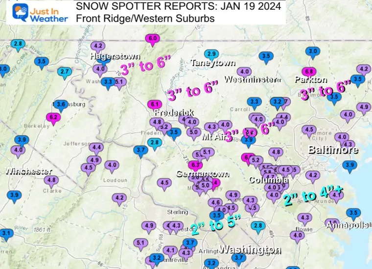
Not only did we get our first accumulating snow in two years this past week, but we had two events! This storm initially looked like the prior one on Tuesday, then pulled back, only to be yet another overachiever. Or, as some have suggested, was it just under forecast? You make the call. I did my best to start conservatively again with my low-end confidence numbers, only to ramp them up for my final call, which also needed another higher adjustment.
I will compare the final snow maps and my forecast maps below. Then, a few close-up region snow spotter reports from NWS and the list of snow totals below.
The current snowpack covers most of the region and has allowed the arctic air to settle in. So we will hold on a bit longer.
The official weather station at BWI has recorded nearly 50% of a normal winter snowfall this past week. If you recall my expectation for an above-average winter, think of this: In a Moderate to Strong El Niño Year, Baltimore has received 75% of the seasonal snowfall AFTER January 20.
This is what was left on the ground this morning.
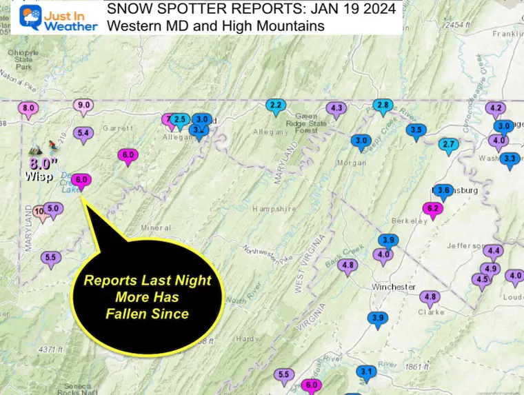
Central Maryland is in the 4 to 8-inch range, and Western Maryland has over 2 Ft.
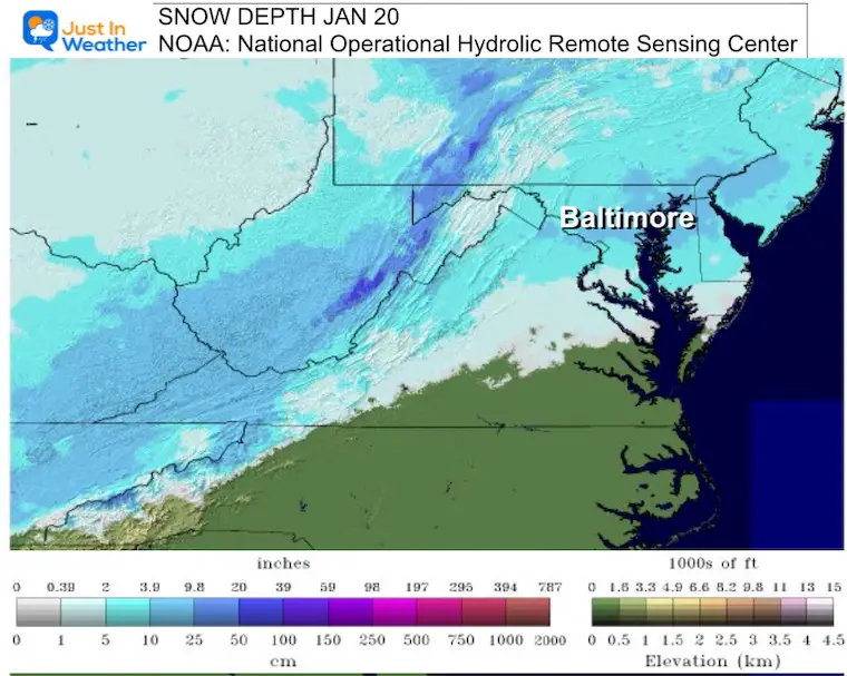
This map only shows the NWS Sterling VA Office Area
Other Maps are below…
(I fixed the date in the title)
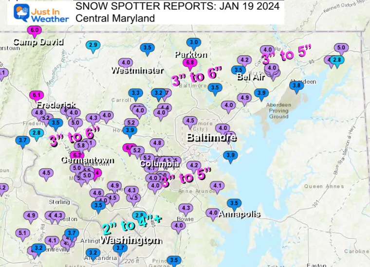
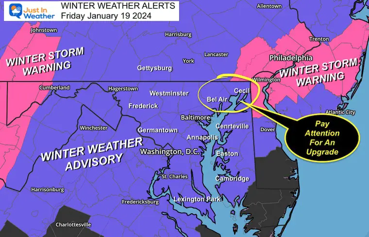
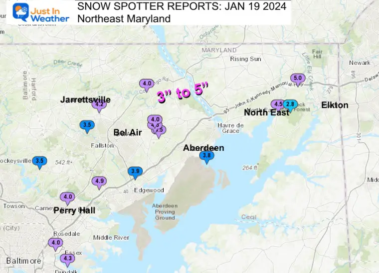
I realized the increase in snow expectations and posted this map with my report to suggest Harford and Cecil Counties in MD would be upgraded to a Winter Storm Warning…
It actually was expanded through central Maryland by NWS on Friday morning.
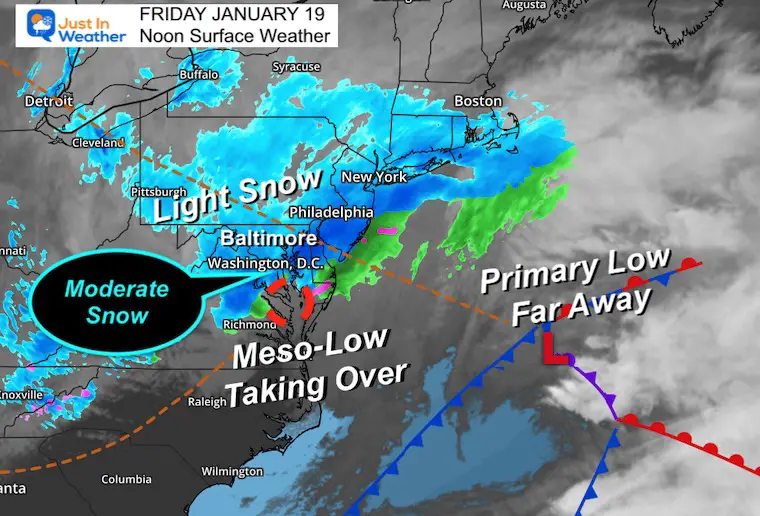
When it began, I posted my belief we would see overachieving results.
The Meso-Low formed as I suggested, which is why we ended up with a higher burst, longer duration, and more on the Eastern Shore.
Was this an Overachiever or Under-Forecast? After looking at the final numbers, it was pretty close, with the tilt to the upside for many but not too far off.

The Garrett County reports were as of 9 PM Friday Night. More has fallen since.
Wisp Ski Resort reported 8 inches, but I’ve seen up to 12″ from local friends in the region.
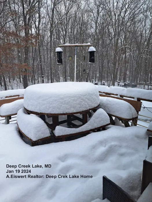
Thanks to A. Eiswert for showing off the deep snowpack. There is at least 2 Ft on the ground and more has been falling since this photo was taken.
This webcam is positioned at The Greene Turtle Deep Creek Lake and shows Wisp Resort, including a zoomed-in view of Squirrel Cage, The Face, the terrain park, Boulder, the mountain coaster, the tubing park and a shot of McHenry Cove at Deep Creek Lake!
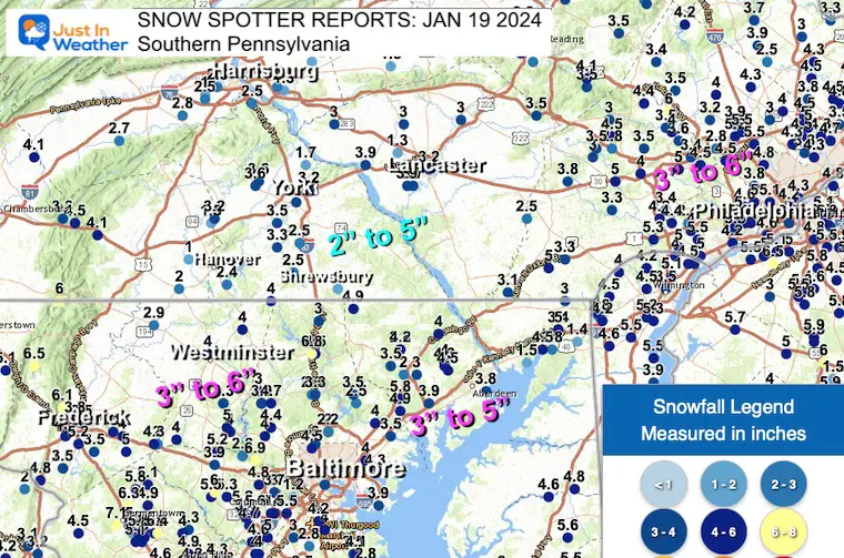
From NWS Sterling, VA
And State College PA for the Southern PA Counties
********************STORM TOTAL SNOWFALL********************
LOCATION TOTAL TIME/DATE COMMENTS
SNOWFALL MEASURED
(inches)
DISTRICT OF COLUMBIA
…District of Columbia…
Catholic University 4.2 925 PM 1/19 NWS Employee
MARYLAND
…Allegany County…
Frostburg 7.0 838 PM 1/19 Trained Spotter
Bellegrove 1 SSE 4.3 430 PM 1/19 Trained Spotter
Potomac Park 2 NW 3.8 100 AM 1/20 Dept of Highways
Ridgeley 1 NW 3.8 934 PM 1/19 Trained Spotter
La Vale 3.0 200 PM 1/19 Dept of Highways
Frostburg 2 ENE 2.5 540 PM 1/19 Trained Spotter
Flintstone 1 ESE 2.2 600 PM 1/19 Trained Spotter
…Anne Arundel County…
Crownsville 3 SSW 4.3 600 PM 1/19 Trained Spotter
Crofton 2 NNE 4.3 405 PM 1/19 NWS Employee
Bwi Airport 4.2 700 PM 1/19 Official NWS Obs
Chelsea Beach 4.1 551 PM 1/19 Trained Spotter
Parole 4.0 700 PM 1/19 Dept of Highways
Cape St. Claire 1 SS 3.5 500 PM 1/19 Trained Spotter
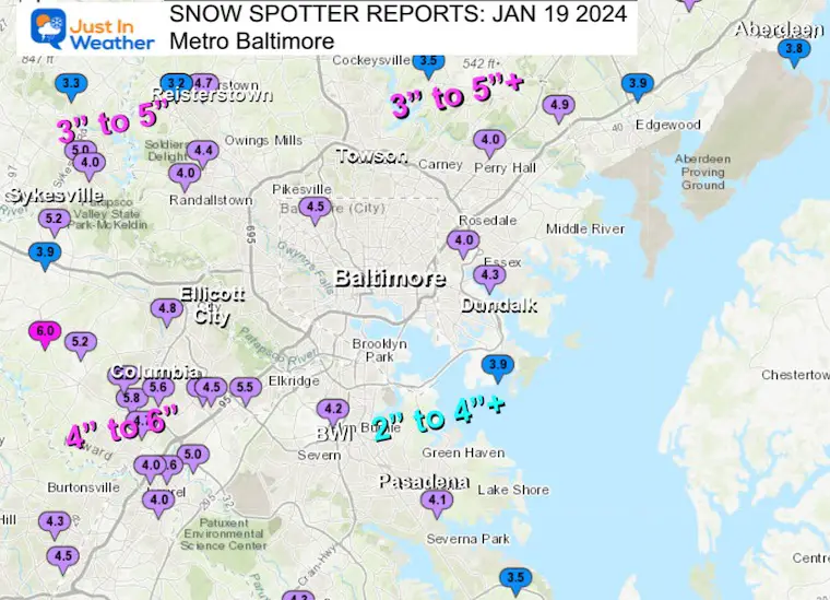
…Baltimore County…
Woodstock 1 ENE 6.9 325 PM 1/19 Trained Spotter
Bentley Springs 6 S 6.8 700 PM 1/19 Dept of Highways
Kingsville 1 E 4.9 700 PM 1/19 Trained Spotter
Glyndon 1 E 4.7 621 PM 1/19 CoCoRaHS
Owings Mills 4.4 700 PM 1/19 Dept of Highways
Essex 1 W 4.3 700 PM 1/19 CoCoRaHS
Rosedale 1 E 4.0 700 PM 1/19 Dept of Highways
Randallstown 2 NW 4.0 235 PM 1/19 Trained Spotter
Perry Hall 1 NNE 4.0 315 PM 1/19 Trained Spotter
Edgemere SE 3.9 342 PM 1/19 Trained Spotter
Glyndon 1 WSW 3.9 807 PM 1/19 Trained Spotter
Reisterstown 1 NW 3.9 500 PM 1/19 CoCoRaHS
Long Green 2 NW 3.5 600 PM 1/19 Trained Spotter
White Marsh 2 E 3.5 535 PM 1/19 Trained Spotter
Glyndon 1 SW 3.2 241 PM 1/19 Trained Spotter
Bentley Springs 1 E 3.0 600 PM 1/19 Trained Spotter
…Baltimore City…
Pimlico SE 4.5 400 PM 1/19 Trained Spotter
…Calvert County…
Prince Frederick 1 S 2.5 700 PM 1/19 Dept of Highways
…Carroll County…
Eldersburg 5.0 245 PM 1/19 Public
Westminster 1 NNE 4.0 700 PM 1/19 Dept of Highways
Eldersburg 1 SE 4.0 630 PM 1/19 Trained Spotter
Manchester 1 SSW 4.0 942 PM 1/19 Trained Spotter
Watersville 1 N 4.0 900 PM 1/19 Trained Spotter
Gamber 1 WNW 3.3 527 PM 1/19 CoCoRaHS
Taneytown NE 2.9 545 PM 1/19 Trained Spotter
…Cecil County…
Pleasant Hill 2 SE 5.0 535 PM 1/19 CoCoRaHS
North East 4.5 705 PM 1/19 Public
North East 2 E 2.8 450 PM 1/19 Trained Spotter
…Charles County…
La Plata 2 NNW 3.0 700 PM 1/19 Dept of Highways
Dentsville 1 SW 2.0 500 PM 1/19 Trained Spotter
Port Tobacco Village 1.3 700 PM 1/19 CoCoRaHS
…Frederick County…
Wolfsville 1 S 6.5 600 PM 1/19 Trained Spotter
Bloomfield 2 WSW 6.1 600 PM 1/19 NWS Employee
Ballenger Creek 1 E 5.2 700 PM 1/19 Dept of Highways
Green Valley 1 WNW 5.0 610 PM 1/19 Public
Point of Rocks 1 NE 4.8 900 PM 1/19 Trained Spotter
Ballenger Creek 1 NN 4.8 800 PM 1/19 Trained Spotter
New Market 2 NW 4.5 800 PM 1/19 CoCoRaHS
Mount Airy 1 WSW 4.3 600 PM 1/19 Trained Spotter
New Market N 4.0 614 PM 1/19 Trained Spotter
New Market 5 WSW 3.5 230 PM 1/19 CoCoRaHS
Adamstown 1 ESE 3.5 930 PM 1/19 NWS Employee
Buckeystown 3 SW 2.8 200 PM 1/19 Trained Spotter
…Garrett County…
Grantsville 5 W 13.5 100 AM 1/20 Dept of Highways
Oakland 10.0 859 PM 1/19 Dept of Highways
Friendsville 3 NW 8.0 840 PM 1/19 Trained Spotter
Deer Park 6 NE 6.0 706 PM 1/19 Trained Spotter
Barton 6.0 856 PM 1/19 Public
Accident 4 E 5.4 500 PM 1/19 Public
Mountain Lake Park 1 5.0 900 PM 1/19 Dept of Highways
…Harford County…
Churchville 1 SE 4.5 700 PM 1/19 Dept of Highways
Churchville 4.3 200 PM 1/19 Dept of Highways
Forest Hill 1 NNW 4.2 800 PM 1/19 Trained Spotter
Scarboro 2 E 4.0 856 PM 1/19 Dept of Highways
Churchville 1 N 4.0 610 PM 1/19 Trained Spotter
Abingdon 1 NW 3.9 415 PM 1/19 Trained Spotter
Aberdeen Proving Gro 3.8 730 PM 1/19 Trained Spotter
Forest Hill 3 SW 3.5 455 PM 1/19 Trained Spotter
…Howard County…
Dayton 1 NE 6.0 700 PM 1/19 Dept of Highways
Simpsonville E 5.8 410 PM 1/19 Trained Spotter
Columbia 5.6 914 PM 1/19 NWS Employee
Elkridge 5.5 524 PM 1/19 NWS Employee
Elkridge 2 W 5.4 405 PM 1/19 Trained Spotter
Clarksville 2 N 5.3 900 PM 1/19 Trained Spotter
Simpsonville 2 NNW 5.2 511 PM 1/19 Trained Spotter
Sykesville 2 SSE 5.2 909 PM 1/19 Trained Spotter
Jessup 2 WSW 5.0 130 PM 1/19 Trained Spotter
Ellicott City 4.8 604 PM 1/19 Broadcast Media
Simpsonville 1 SSE 4.7 220 PM 1/19 Trained Spotter
Laurel 3 NNE 4.6 215 PM 1/19 Trained Spotter
Elkridge 2 WSW 4.5 420 PM 1/19 Trained Spotter
Laurel 2 N 4.0 430 PM 1/19 Trained Spotter
West Friendship 2 NW 3.9 454 PM 1/19 Trained Spotter
…Montgomery County…
Germantown 2 WSW 7.1 900 PM 1/19 Trained Spotter
Washington Grove 1 N 6.4 700 PM 1/19 Trained Spotter
Clarksburg 2 SE 6.3 741 PM 1/19 Public
Gaithersburg 5.8 700 PM 1/19 Dept of Highways
Damascus 3 SSW 5.8 607 PM 1/19 Co-Op Observer
Washington Grove 1 N 5.8 943 PM 1/19 Trained Spotter
Montgomery Village 1 5.5 500 PM 1/19 CoCoRaHS
Gaithersburg 1 SW 5.3 130 PM 1/19 Public
Damascus 1 SE 5.1 600 PM 1/19 Trained Spotter
Gaithersburg 1 ESE 5.0 200 PM 1/19 Public
Germantown 1 SE 5.0 630 PM 1/19 Trained Spotter
Laytonsville 2 WNW 4.9 1010 PM 1/19 Trained Spotter
Norbeck 1 ESE 4.9 800 PM 1/19 Trained Spotter
Rockville 1 SSE 4.6 400 PM 1/19 Trained Spotter
Poolesville 4.5 715 PM 1/19 Trained Spotter
Glenmont 1 SW 4.5 230 PM 1/19 Trained Spotter
Calverton 1 SW 4.5 700 PM 1/19 Dept of Highways
Fairland 1 W 4.3 536 PM 1/19 Trained Spotter
Glenmont 1 NNE 4.3 445 PM 1/19 Trained Spotter
Garrett Park 1 WNW 4.0 307 PM 1/19 Public
Bethesda 2 NNW 3.5 415 PM 1/19 Trained Spotter
…Prince Georges County…
Laurel 1 E 4.0 700 PM 1/19 Dept of Highways
Bowie 2 SSE 4.0 200 PM 1/19 NWS Employee
Upper Marlboro 1 S 3.5 700 PM 1/19 Dept of Highways
College Park 1 S 2.8 800 PM 1/19 Trained Spotter
…St. Marys County…
Clements 3 E 1.3 700 PM 1/19 Dept of Highways
Leonardtown 0.8 230 PM 1/19 Dept of Highways
California 3 W 0.5 700 PM 1/19 Trained Spotter
…Washington County…
Sabillasville 2 NNW 6.0 546 PM 1/19 CoCoRaHS
Boonsboro 3 NNE 5.1 630 PM 1/19 Trained Spotter
Maugansville WSW 4.2 500 PM 1/19 Trained Spotter
Funkstown 2 WSW 4.0 700 PM 1/19 Dept of Highways
Fairplay 3 ENE 3.3 400 PM 1/19 Trained Spotter
Hagerstown 3.0 200 PM 1/19 Dept of Highways
Hancock 1 ESE 2.8 600 PM 1/19 Trained Spotter
…Adams County…
5 WNW Cashtown 4.5 in 0133 PM 01/19 Public
1 W Cashtown 4.1 in 0115 PM 01/19 CO-OP Observer
1 S East Berlin 3.2 in 0215 PM 01/19 Trained Spotter
…York County…
Dover 3.6 in 0639 PM 01/19 Trained Spotter
Dover 3.6 in 0643 PM 01/19 Public
1 NE New Salem 3.5 in 0419 PM 01/19 Trained Spotter
1 W Seven Valleys 3.3 in 0637 PM 01/19 Trained Spotter
Glen Rock 2.5 in 0115 PM 01/19 Public
…Lancaster County…
1 WSW Millersville 3.9 in 0642 PM 01/19 Trained Spotter
Millersville 3.7 in 0300 PM 01/19 Trained Spotter
2 NW Leola 3.4 in 0334 PM 01/19
Lancaster 3.2 in 0116 PM 01/19 Public
…Arlington County…
Reagan National Apt 3.7 700 PM 1/19 Official NWS Obs
…City of Fredericksburg…
Fredericksburg 2 E 1.0 213 PM 1/19 Trained Spotter
…City of Waynesboro…
Waynesboro 0.8 211 PM 1/19 Broadcast Media
…Clarke County…
Berryville 1 NNW 4.8 815 PM 1/19 Trained Spotter
…Culpeper County…
Cardova 2 NW 1.6 145 PM 1/19 Trained Spotter
…Fairfax County…
Centreville 2 WSW 4.9 745 PM 1/19 Trained Spotter
Herndon 1 NNE 4.7 315 PM 1/19 Trained Spotter
Reston 2 N 4.3 345 PM 1/19 Trained Spotter
Fairfax 1 N 4.3 600 PM 1/19 NWS Employee
Vienna 4.3 230 PM 1/19 Co-Op Observer
Chantilly 2 ENE 4.1 640 PM 1/19 Trained Spotter
Vienna 1 WNW 3.7 346 PM 1/19 Trained Spotter
Hybla Valley 1 ESE 3.7 145 PM 1/19 Trained Spotter
Lincolnia 1 WNW 3.2 200 PM 1/19 Trained Spotter
Centreville W 3.2 830 PM 1/19 Trained Spotter
Lorton 2.6 330 PM 1/19 NWS Employee
…Frederick County…
Hayfield 1 N 4.8 325 PM 1/19 Trained Spotter
Cedar Grove 2 ENE 4.0 515 PM 1/19 Trained Spotter
Stephens City 2 E 3.9 245 PM 1/19 Trained Spotter
Cedar Hill 4 NNW 3.9 313 PM 1/19 Trained Spotter
…Loudoun County…
Arcola 3 S 5.1 515 PM 1/19 Trained Spotter
Dulles International 4.9 700 PM 1/19 Official NWS Obs
Bloomery 3 ESE 4.9 500 PM 1/19 Trained Spotter
Hughesville 1 ESE 4.2 445 PM 1/19 Trained Spotter
Hillsboro 3 NE 4.0 536 PM 1/19 Trained Spotter
…Page County…
Ida 1 SW 2.0 228 PM 1/19 Trained Spotter
Honeyville 1 ESE 1.3 245 PM 1/19 Trained Spotter
…Prince William County…
Independent Hill 3 N 3.1 500 PM 1/19 Trained Spotter
Independent Hill 2 E 3.0 300 PM 1/19 Trained Spotter
Dale City 1 W 2.0 500 PM 1/19 Trained Spotter
…Rockingham County…
Criders 3 ENE 2.0 638 PM 1/19 Bergton area
Dale Enterprise 2 NN 2.0 638 PM 1/19 Mt. Clinton area
…Shenandoah County…
Toms Brook 3 SSE 6.0 200 PM 1/19 Trained Spotter
Alonzaville 2 ENE 5.5 500 PM 1/19 Trained Spotter
Edinburg 2 E 2.5 200 PM 1/19 Trained Spotter
…Stafford County…
Ramoth 1 W 2.0 330 PM 1/19 Trained Spotter
Glendie 1 N 1.6 230 PM 1/19 Trained Spotter
…Warren County…
Karo 1 WSW 3.9 300 PM 1/19 Trained Spotter
Riverton 1 WNW 3.1 345 PM 1/19 Trained Spotter
WEST VIRGINIA
…Berkeley County…
Martinsburg Arpt 1 N 6.2 515 PM 1/19 Trained Spotter
Martinsburg 2 E 3.6 502 PM 1/19 NWS Employee
Shepherdstown 4 NNW 3.6 925 PM 1/19 Trained Spotter
Falling Waters 2 NW 2.7 215 PM 1/19 Trained Spotter
…Grant County…
Bayard 5.5 225 PM 1/19 Co-Op Observer
…Jefferson County…
Bloomery 3 SSE 4.5 500 PM 1/19 Trained Spotter
Millville 1 ESE 4.4 404 PM 1/19 Trained Spotter
…Morgan County…
Cherry Run 3.5 414 PM 1/19 Trained Spotter
Berryville 1 SW 3.0 210 PM 1/19 Dept of Highways
…Pendleton County…
Cherry Grove 6 WSW 2.0 229 PM 1/19 Trained Spotter
Click here or the map to see: The Snow Report Ending Jan 16


Click to see more and ‘Book’ a visit to your school


Computer Models Support East Coast Storm Track

The latest NOAA report is confident in a Very Strong event. Possibly HISTORIC! This refers to the temperatures in the Pacific, with impacts on the US Winter Storm Track.

Winter Weather Folklore: Top 20 and more signals from nature for snow.
Winter Outlook 2024 From Two Farmers Almanacs Return to Cold and Snow
I am aware there are some spelling and grammar typos and occasional other glitches. I take responsibility for my mistakes and even the computer glitches I may miss. I have made a few public statements over the years, but if you are new here, you may have missed it: I have dyslexia and found out during my second year at Cornell University. It didn’t stop me from getting my meteorology degree and being the first to get the AMS CBM in the Baltimore/Washington region. One of my professors told me that I had made it that far without knowing and to not let it be a crutch going forward. That was Mark Wysocki, and he was absolutely correct! I do miss my mistakes in my own proofreading. The autocorrect spell check on my computer sometimes does an injustice to make it worse. I also can make mistakes in forecasting. No one is perfect at predicting the future. All of the maps and information are accurate. The ‘wordy’ stuff can get sticky. There has been no editor who can check my work when I need it and have it ready to send out in a newsworthy timeline. Barbara Werner is a member of the web team that helps me maintain this site. She has taken it upon herself to edit typos when she is available. That could be AFTER you read this. I accept this and perhaps proves what you read is really from me… It’s part of my charm. #FITF