


July 18 Flood Watch In The Mountains Then Storms Expand Back This Weekend
Friday, July 18 2025 Morning Report There is some relief in sight, but I remain cautious. For the short term, today remains muggy, while the focus of strong storms and…
November 10, 2023
The latest NOAA report continues the El Niño Advisory through the Winter with the potential to last into Spring. There is a 35% chance this may be a historic El Niño to rival the intensity of 1997-98 and 2015-16 with respect to the warm water in the Tropical Pacific Ocean.
What is often the case with El Niño winters on the East Coast is showing up in the seasonal computer models.
If you want more info about El Niño, I will link to my prior articles below.
This report will look at the European ECMWF Model and CFSv2 from the National Centers for Environmental Prediction (NCEP).
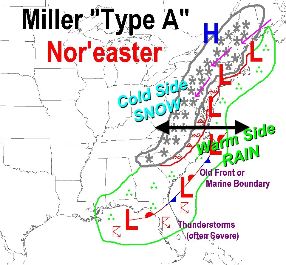
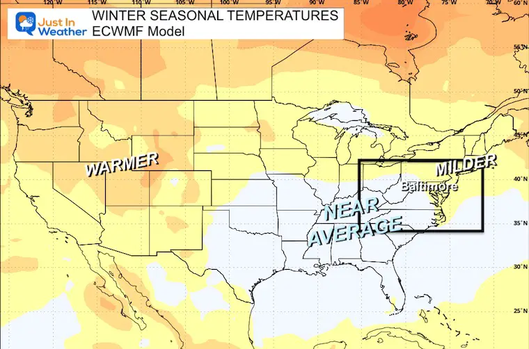
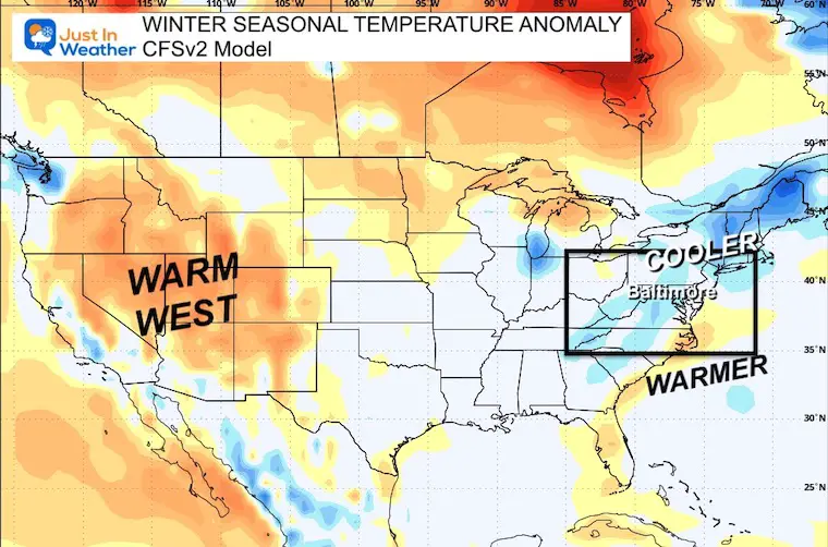
Important Note: The “Above Average” snowfall for the East Coast is based on an active Southern Storm Track. This includes Gulf Coast and East Coast Nor’easters.
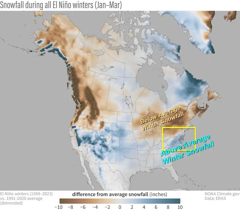
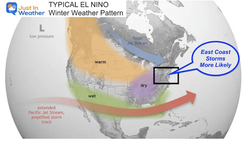
Typical El Niño Winters have a stronger Southern Branch Jet Stream. That can lead to frequent strong Gulf and East Coast Storms. The challenge is if that will be a warm or cold track for us.
Snowfall in Baltimore During Moderate to Strong El Niño Winters
Since 1970, there have been 8 winters in this category. Of them:
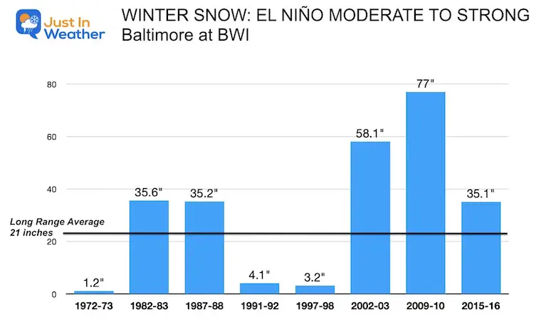
Closer Inspection Of The Two Strongest El Niños
This depends on two factors: The precise storm track and linking cold air with storms, while winter can end up warmer. See more below.
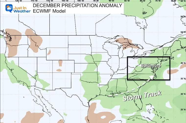
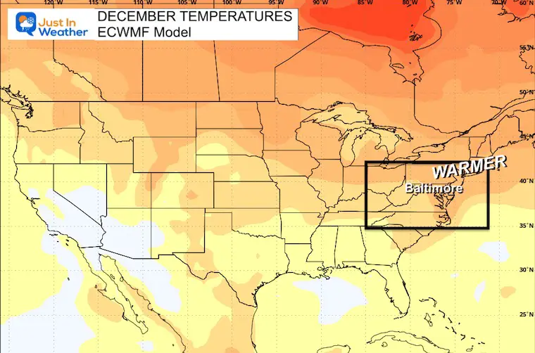
Suggestion: Active storm activity. We could use this for the growing drought.
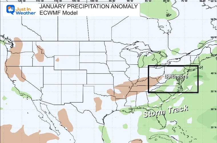
Suggestion: A little less active.
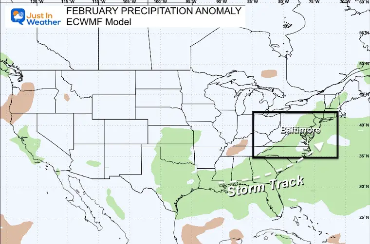
Suggestion: A resurgence of storms during the month we often get our biggest snow.
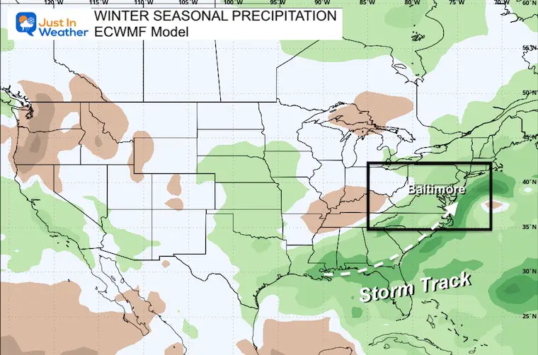
Suggestion: This supports the same storm track. Note that the blue shade is more precipitation, but that would occur in the warm rain sector. This leaves the door open for the colder snow and or ice inland.

This is the typical type of storm we get with an active Southern Branch Jet Stream.
It is important to note the NON-PROMISE
This is the paradox. An El Niño is more likely to bring temperatures warmer than average. There can be arctic outbreaks AND also cold air just syncing up with storms, then mild in the time between other storms.
It can also average warmer with one very warm month and the other months near or a little colder than average.
Suggestion: Much Warmer than average, but we can still get cold spells with storms.
Suggestion: Near Average for the Mid-Atlantic. Colder than average with the busier storm track across the Southeast and Gulf Coast region.
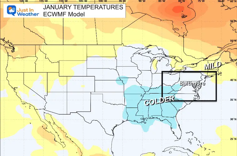
Suggestion: Near Average for the Mid-Atlantic. Colder than average with the busier storm track across the Southeast and Gulf Coast region.
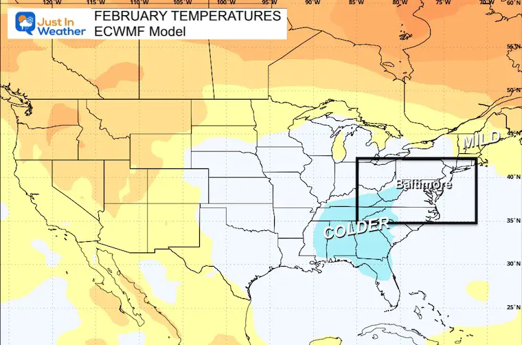
This model actually strays from the norm and shows a colder Mid-Atlantic AND Northeast US. This suggests that perhaps there will be more cold air in place with that active storm track.
Note: I have a little more analysis for my research. I plan to finalize and publish my Winter Outlook and snowfall suggestion next week.

The latest NOAA report is confident in a Very Strong event. Possibly HISTORIC! This refers to the temperatures in the Pacific, with impacts on the US Winter Storm Track.

Winter Weather Folklore: Top 20 and more signals from nature for snow.
Winter Outlook 2024 From Two Farmers Almanacs Return to Cold and Snow
Sign up and be the first to know!

Click to see more and ‘Book’ a visit to your school

I am aware there are some spelling and grammar typos and occasional other glitches. I take responsibility for my mistakes and even the computer glitches I may miss. I have made a few public statements over the years, but if you are new here, you may have missed it: I have dyslexia and found out during my second year at Cornell University. It didn’t stop me from getting my meteorology degree and being the first to get the AMS CBM in the Baltimore/Washington region. One of my professors told me that I had made it that far without knowing and to not let it be a crutch going forward. That was Mark Wysocki, and he was absolutely correct! I do miss my mistakes in my own proofreading. The autocorrect spell check on my computer sometimes does an injustice to make it worse. I also can make mistakes in forecasting. No one is perfect at predicting the future. All of the maps and information are accurate. The ‘wordy’ stuff can get sticky. There has been no editor who can check my work when I need it and have it ready to send out in a newsworthy timeline. Barbara Werner is a member of the web team that helps me maintain this site. She has taken it upon herself to edit typos when she is available. That could be AFTER you read this. I accept this and perhaps proves what you read is really from me… It’s part of my charm.
#FITF