


July 12 Very Humid With Scattered Thunderstorms Later And More Storms Tomorrow
Saturday, July 12, 2025 Morning Report This may sound familiar: We remain in the ambiguous humid air mass. There is thick fog this morning, and the sun will dominate the…
October 19 2023
The National Oceanographic and Atmospheric Administration (NOAA) released its winter outlook today for the 2023 to 2024 winter season. As expected, the current El Niño is the first time in the last four years to be playing a dominant role. I need to state a few things before diving into the report because it is actually quite complicated. This is where some may throw up their hands and say ‘it will be what it will be’. But if you are like me, then you want to dig deeper to understand and maybe outguess Mother Nature.
1) This report is from the Climate Prediction Center. It is their outlook, not mine. I will release my ‘suggestion’ for this winter separately.
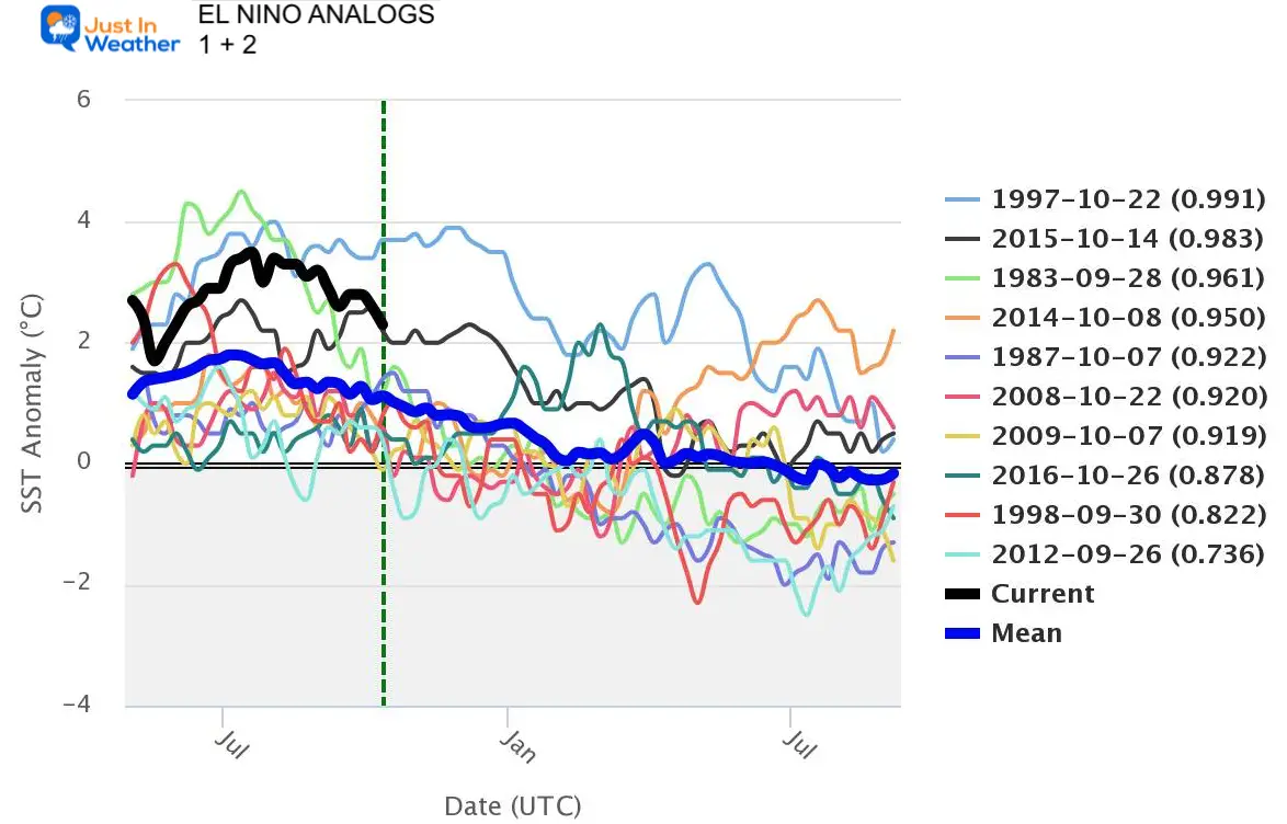
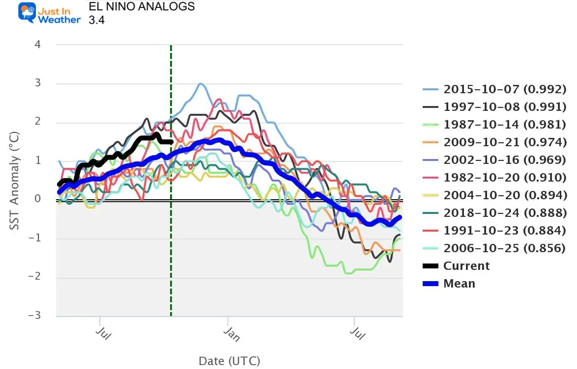
2) Not all El Nino’s are the same. I have written about the intensity and resulting snow for our region. I did include some of my own reporting for additional info.
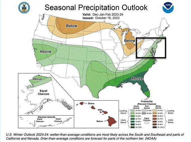
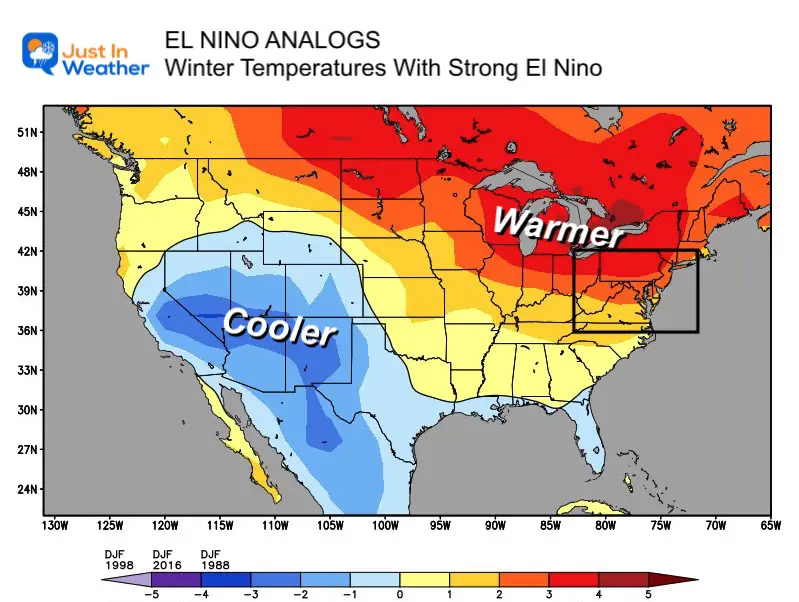
3) The maps show NOAA’s expectations compared to average. Where temps are ‘warmer’, it will be overall compared to average. Not just WARM. There will still be colder spells, and there is no designation to cold timing out with storms, then warming in between… or the other way around.
4) This is only one mechanism and not the only force on the overall weather pattern. A strong El Niño can dominate with warmth, but a moderate El Niño will bring in moisture and allow other forces to combine it with colder air.
“These outlooks provide critical guidance on the upcoming season for many industries and sectors of our economy, from energy producers to commodities markets to agricultural interests to tourism,” said Sarah Kapnick, Ph.D., NOAA chief scientist. “With a strengthening El Nino and more potential climate extremes in an already record-breaking year, we’re lucky to have scientists like those at the Climate Prediction Center helping to build a Weather and Climate-Ready Nation by providing critical operational seasonal climate predictions.”
From December through February, NOAA predicts wetter-than-average conditions for northern Alaska, portions of the West, the southern Plains, Southeast, Gulf Coast, and lower mid-Atlantic and drier-than-average conditions across the northern tier of the U.S., especially in the northern Rockies and High Plains and near the Great Lakes.
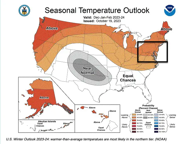
NOAA’s seasonal outlooks provide the likelihood that temperatures and total precipitation amounts will be above, near, or below average and how drought conditions are anticipated to change in the months ahead. The outlook does not project seasonal snowfall accumulations as snow forecasts are generally not predictable more than a week in advance.
NOAA’s Climate Prediction Center updates the three-month outlook each month. The next update will be available Nov. 16.
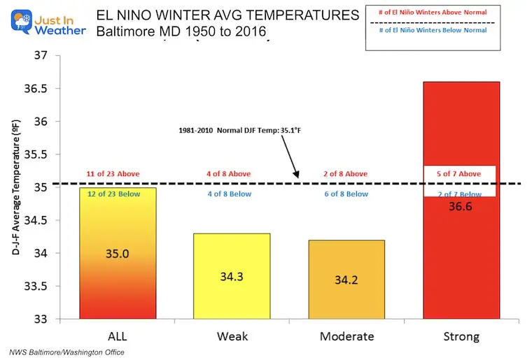
I wrote this report with a focus on Baltimore’s snow records. Yes, we have had winters with heavy snow in Moderate El Niños. But if El Niño is STRONG, it overwhelms the Pacific Jet Stream to a more zonal flow that inhibits cold air outbreaks.
Temperatures at BWI From The National Weather Service
Contrary to the map above, the average El Niño winter is slightly cooler than average. A Weak and Moderate El Niño tends to be colder.
If the El Niño is Strong, then the dominant Pacific Jet Stream tends to make winters quite warm.
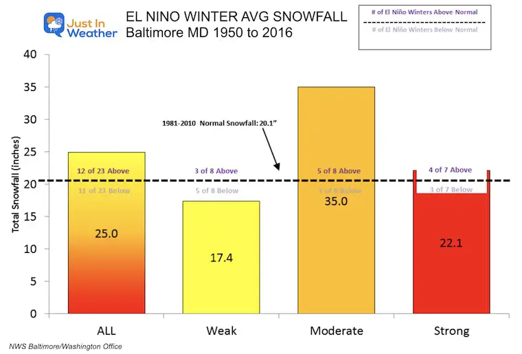
Measured at BWI From The National Weather Service
The average El Niño winter brings more snow. In this sample, 25% higher or 5 inches of additional snow. Then again, any snowfall will be more than last winter’s record 0.2”.
The sweet spot for big snowfall is with a Moderate El Niño. In the 8 winters that had an El Niño, 5 produced more snow, and the overall average was 35 inches or 75% above normal!
A Strong El Niño also has a tendency to produce above-average snowfall. Considering that this also can bring a warmer winter helps show that we can have cold storms in the middle of a warmer season.
An average El Niño brings above-average precipitation. This is snow and rain combined, and it’s great news, considering the drought our region has been experiencing all year.
The strength of the El Niño will determine the storm activity. More can be expected with a Moderate and Strong El Niño.
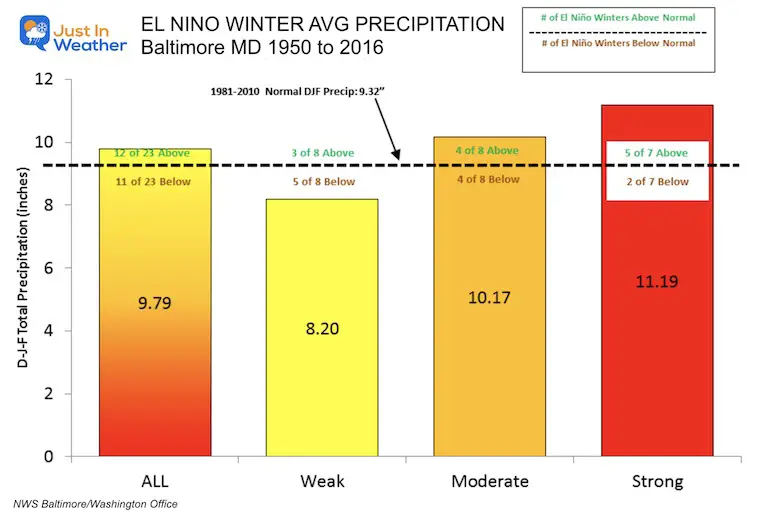
If you have Faith in the Flakes and want snow, then a Moderate El Niño is what you may be hoping for.
I agree with the analysis from Mike Thomas from Fox 5 in Washington, so I would like to share what he recently posted to give him credit.
*Most El Niño winters after La Niña are colder than normal
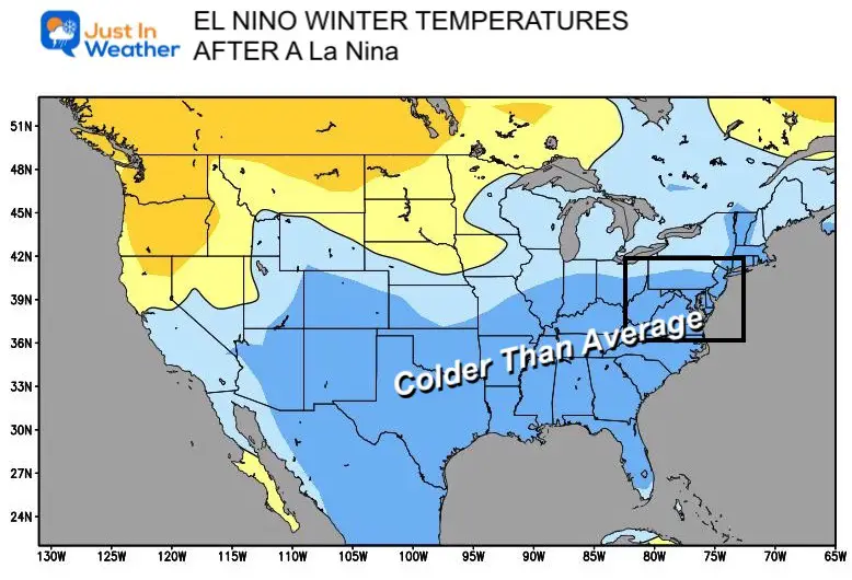
*However, current analogs for Niño 3.4 & 1+2 STTs only share 3 winters. (87-88, 97-98, 15-16). All strong Niño years:
*2/3 were WARM winters, BUT 2/3 had big snows! Tricky!
Additional Winter Forecasting Tools:
Here’s What’s New at NOAA this Year
I will have a follow-up and recap on our amazing week shortly.

Sign up and be the first to know!

Click to see more and ‘Book’ a visit to your school

I am aware there are some spelling and grammar typos and occasional other glitches. I take responsibility for my mistakes and even the computer glitches I may miss. I have made a few public statements over the years, but if you are new here, you may have missed it: I have dyslexia and found out during my second year at Cornell University. It didn’t stop me from getting my meteorology degree and being the first to get the AMS CBM in the Baltimore/Washington region. One of my professors told me that I had made it that far without knowing and to not let it be a crutch going forward. That was Mark Wysocki, and he was absolutely correct! I do miss my mistakes in my own proofreading. The autocorrect spell check on my computer sometimes does an injustice to make it worse. I also can make mistakes in forecasting. No one is perfect at predicting the future. All of the maps and information are accurate. The ‘wordy’ stuff can get sticky. There has been no editor who can check my work when I need it and have it ready to send out in a newsworthy timeline. Barbara Werner is a member of the web team that helps me maintain this site. She has taken it upon herself to edit typos when she is available. That could be AFTER you read this. I accept this and perhaps proves what you read is really from me… It’s part of my charm.
#FITF