


Severe Thunderstorm Watch and Flood Watch Tuesday
Tuesday Afternoon Update July 1 2024 The atmosphere is juicy! Dew points are high in the mid to upper 70s, which means there is the potential for heavy rainfall and…
February 6, 2024
I am writing this from the perspective of the Mid-Atlantic region of the United States. After a busy snow week in January, it has all melted away, and it seems like winter is nonexistent. The long-range outlook this month begs to differ.
The last two years have featured such low snow that the two storms we had in mid-January beat that!
Using Baltimore’s BWI: The seasonal snow is currently 9.1”, which is only 1.4” below average since December 1, within reason for the season.
The current weather pattern is dry and cool, but we expect temperatures into the 60s this weekend. I realize there is a belief that with no snow on the ground and a few warm days, it may feel like winter is done. This is far from the case. First, I have seen countless times when a warm day or stretch in winter is quickly matched with cold and snow. In fact, often, the jet stream that will buckle to produce a warm day will flip and bring in the cold to balance things out. The law of averages can sometimes mean the warmer the warmth with be followed by colder COLD!
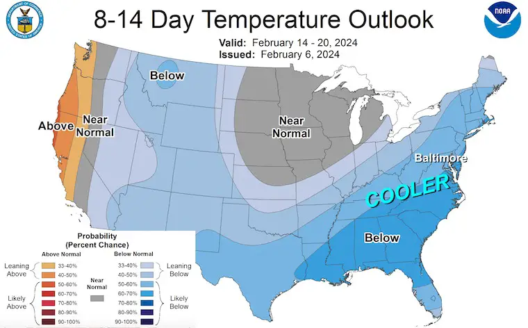
The trend from Valentine’s Week, February 14 to 20, is shown here with the Eastern US ‘Below’ or colder than average.
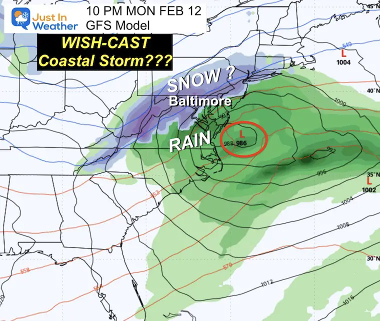
In my last two morning reports, I have shown the GFS Model with a “Wish-Cast” for snow. I DO NOT trust any model forecast beyond one week. In fact, I broke protocol to show the maps only to provide some hope. This also needs a reality check.
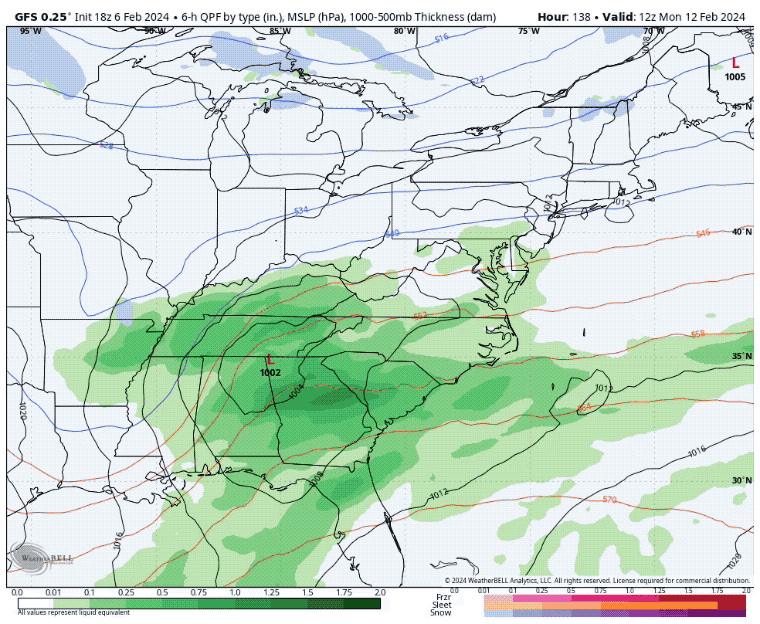
The GFS Model is still trying to turn the corner with Low Pressure and bring in snow Monday night.
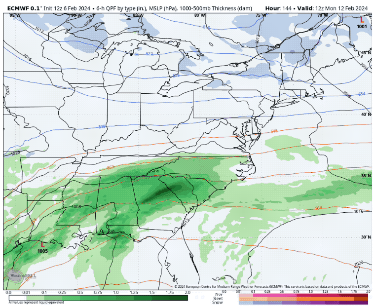
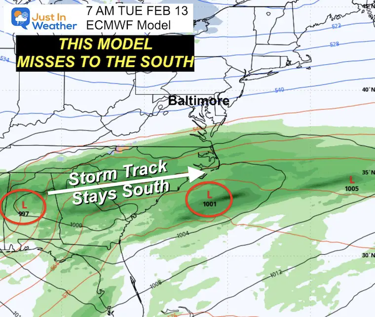
The ECMWF Model has the jet stream suppressed to our south, keeping rain across the Carolinas and missing us.
Note: I believe both models below still don’t have the final solution. We may end up with something of a hybrid in between:
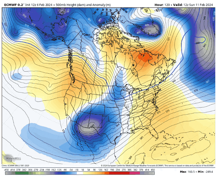
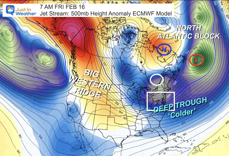
Here, we see the development of a Winter Weather Pattern that is worthy of interest.
Left: A large Ridge dominates the west coast of North America.
Right: A distinct Negative North Atlantic Oscillation (-NAO)/Greenland Block develops with a Ridge over Greenland and Closed Low to the South over the Atlantic.
Eastern US Trough: This is a weather pattern that will be fed by the cold of the -NAO down the East Coast. This supports the colder temperatures and the potential for storms to bring snow.
Trending Negative through February 20.
This signals a colder and more stormy weather pattern for Eastern North America.
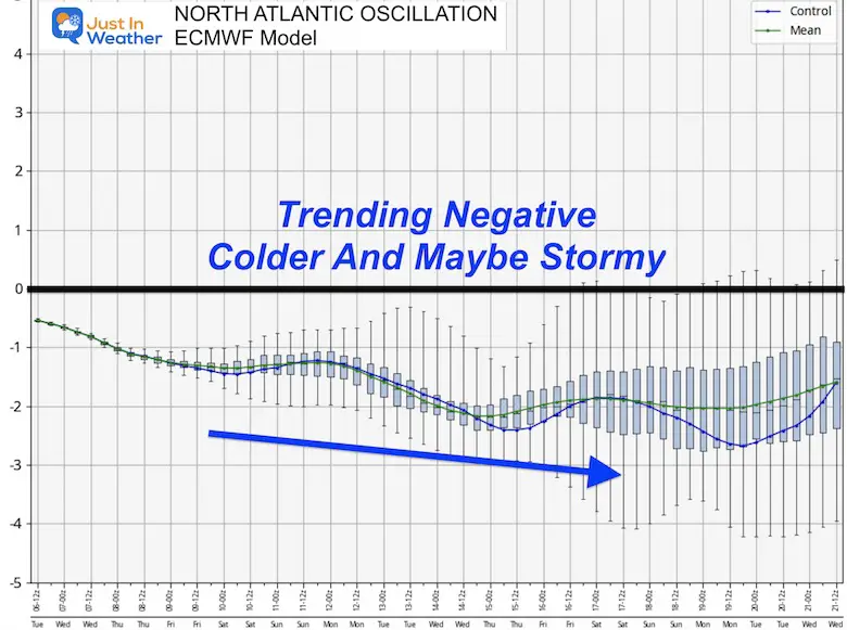
This trending positive does mean a warmer pattern for Western North America but also supports the trough and cold for Eastern North America.
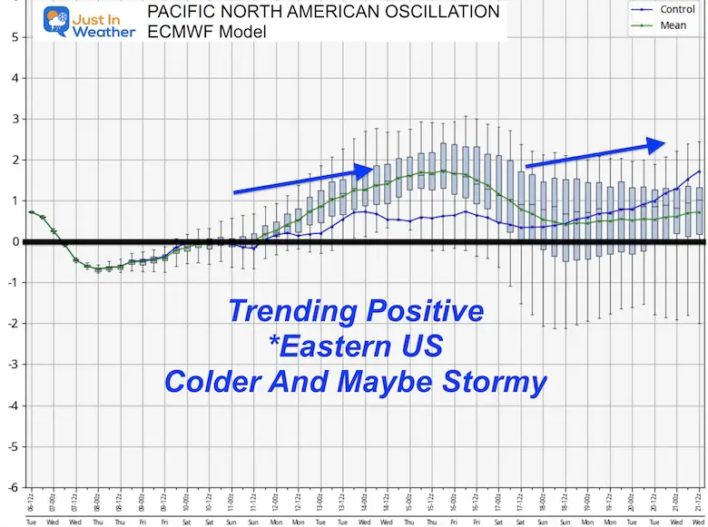
This is simply an outlook and not a promise of any specific weather event. However, this does comply with our statistical tendency to see snow, most likely in the middle of February.
Also: Moderate to Strong El Niño winters have 75% of snowfall AFTER January 20. We are still in the thick of winter!
#FITF
Click here for the maps and full report
Click here or the map to see: The Snow Report Ending Jan 16


Click to see more and ‘Book’ a visit to your school


Computer Models Support East Coast Storm Track

The latest NOAA report is confident in a Very Strong event. Possibly HISTORIC! This refers to the temperatures in the Pacific, with impacts on the US Winter Storm Track.

Winter Weather Folklore: Top 20 and more signals from nature for snow.
Winter Outlook 2024 From Two Farmers Almanacs Return to Cold and Snow
I am aware there are some spelling and grammar typos and occasional other glitches. I take responsibility for my mistakes and even the computer glitches I may miss. I have made a few public statements over the years, but if you are new here, you may have missed it: I have dyslexia and found out during my second year at Cornell University. It didn’t stop me from getting my meteorology degree and being the first to get the AMS CBM in the Baltimore/Washington region. One of my professors told me that I had made it that far without knowing and to not let it be a crutch going forward. That was Mark Wysocki, and he was absolutely correct! I do miss my mistakes in my own proofreading. The autocorrect spell check on my computer sometimes does an injustice to make it worse. I also can make mistakes in forecasting. No one is perfect at predicting the future. All of the maps and information are accurate. The ‘wordy’ stuff can get sticky. There has been no editor who can check my work when I need it and have it ready to send out in a newsworthy timeline. Barbara Werner is a member of the web team that helps me maintain this site. She has taken it upon herself to edit typos when she is available. That could be AFTER you read this. I accept this and perhaps proves what you read is really from me… It’s part of my charm. #FITF