I truly hope that as you take the time to read my thoughts, and not just come here for the pictures, you know I do that same.I may not get to answer everyone’s specific questions, but I like to get the pulse on social media of the comments around my posts.
The bulk today has been around two things:
My snow call is too high
Ground temps are too warm
I thought I had addressed both of these issues in my prior posts, but I will dive into again here.I will also share the computer model guidance for you to compare my forecast. I actually went LOWER than the NAM and GFS models.In fact the latest NAM went bonkers with snow. It has a tendency to do that, which is why I won’t bite on it or blast it on social media. But I will show you in the mix below.
As promised, I also have an hourly timeline slider for the NAM 3Km Simulation.
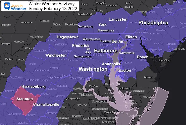
Winter Weather Advisory:
This is from The National Weather Service, and confirms my forecast thoughts. Most, but not all in these areas will have impact on travel in the morning. The farther south there will be some delay with the transition from melting snow to stickage on the ground.
However the Temperatures breakdown I will share does help show who has the best chance.
Evening Set Up
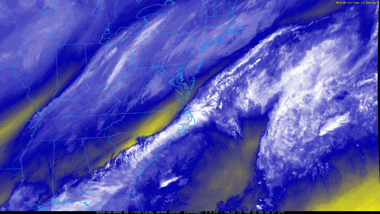
Water Vapor Satellite Loop
Here we can see two bands of bright clouds.This is the split branches of the jet stream trying to phase…
The inland band is where our snow event will develop. This is a Jet Streak, faster moving air aloft that will enhance snow closer to the front.
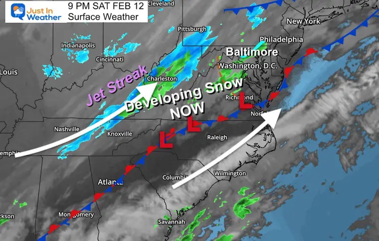
Saturday Night Surface Weather
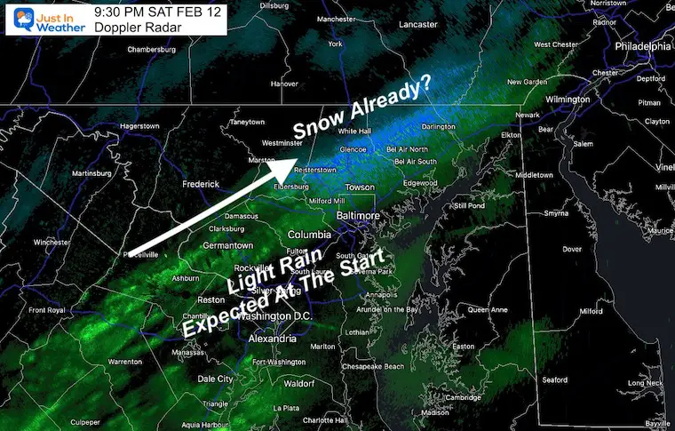
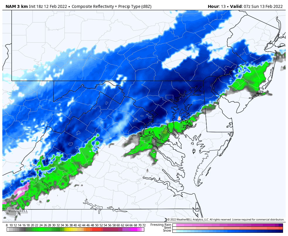
Radar Snapshot
Rain and snow is showing on radar…
This is appearing a little ahead of schedule. The latest enhancement of snow over Baltimore County may begin to reach the ground sooner… This may also help to cool that air faster! See the temperature set up below.
Nowcasting
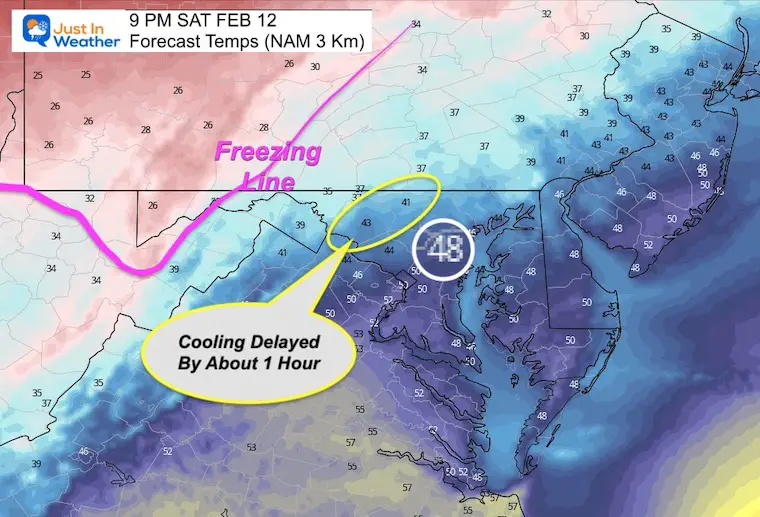
One trick is to look at the latest conditions and compare the the most recent forecast. I had mentioned my reliance on the NAM 3Km this time, but it is NOT PERFECT.Check this out:
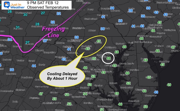
BWI has been highlighted as close to expectations.
Federick and Westminster (yellow) are delayed by about 1 hour with their cooling.
The Freezing Line is pretty close to the forecast for this time.
Overall the Model is performing well with the arrival of the cold air so far.
Observations at 9 PM
COMPARE TO
Forecast For 9 PM
Here we can see the temps are not as cold as suggested.
A deeper look shows that the cooling is about 1 hour later.I already mentioned this possibility in my last report.
If we account for this with the short term forecast, it is still enough time for the ground temps to sustain stickage before sunrise around metro Baltimore.The southern edge (what I mentioned with the Advisory) may remain with wet roads (south of Annapolis and Easton)
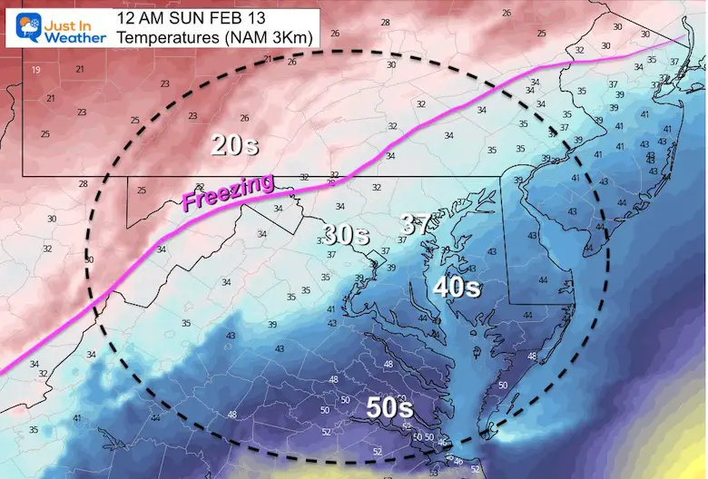
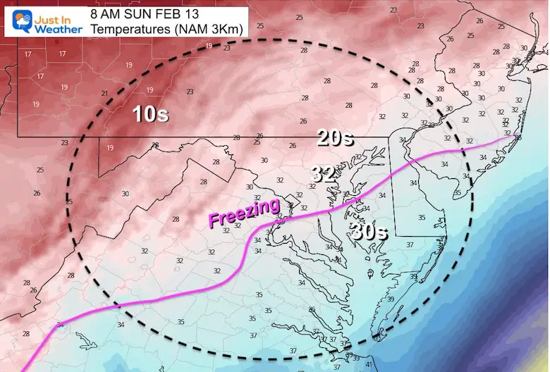
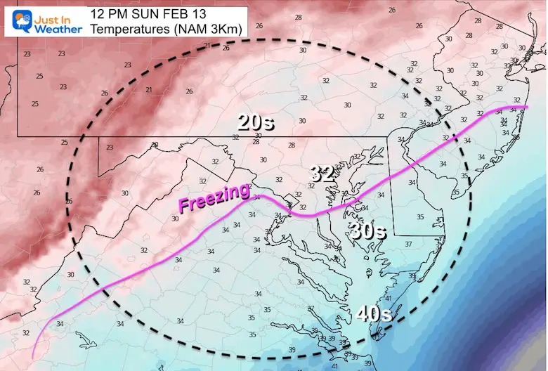
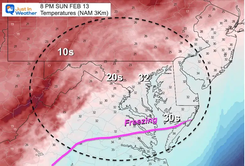
Temperature Forecast Plots
Consider a 2 hour delay of the arrival of cold..
Midnight – 12 AM Sunday
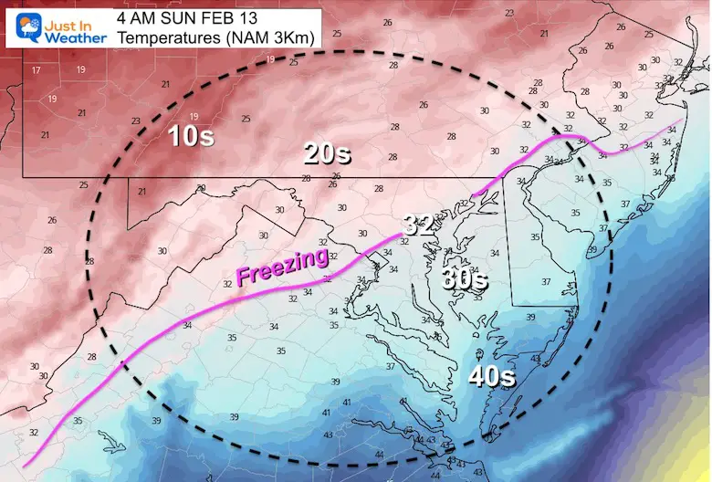
4 AM Sunday
*If you apply a conservative 2 hour error, then the freezing line should still reach this spot by 6 AM. That still allows for a few hours of steady snow to cool the ground BEFORE any influence of sunlight (through the clouds)
8 AM Sunday
*If you apply the 2 hour error, then the freezing line should still reach this spot by 10 AM. That is when the filtered sunlight will impact roads.
Noon – 12 PM Sunday
This should be on schedule where the cold will establish and hold for the day.
Night – 8 PM Sunday
This freeze should be considered where the ground is wet.
More people will be walking and driving home for Super Bowl Parties, so expect icing if not treated.
Snow Forecast Animation
2 AM Sunto 8 PM Sun
Hourly Timeline —> slider
(I prepare only the even hours here due to my time limitation)
february-13-weather-snow-radar-sunday-am-2
february-13-weather-snow-radar-sunday-am-4
february-13-weather-snow-radar-sunday-am-6
february-13-weather-snow-radar-sunday-am-8
february-13-weather-snow-radar-sunday-am-10
february-13-weather-snow-radar-sunday-pm-12
february-13-weather-snow-radar-sunday-pm-2
february-13-weather-snow-radar-sunday-pm-4
february-13-weather-snow-radar-sunday-pm-6
february-13-weather-snow-radar-sunday-pm-8
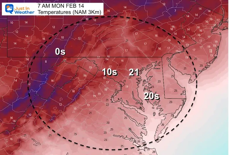
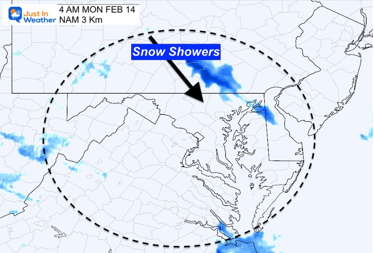
Monday Morning
Some snow showers may arrive across PA into Northeast Maryland before sunrise.
Temps will be in the Deep Freeze at daybreak.
Notes:
This update slows the line of snow, so it may linger past noon in metro Baltimore.
Snow on the roads near and north of Annapolis during the Morning.
Rt. 50 may be close to where the pavement may stay wet.Use this with a 10 to 20 mile buffer for the roads to possibly to stay wet.
After 9 or 10 AM the ground is more likely to be wet.
Southern Maryland will have more snow afternoon and to evening by the beaches. That is where the wet ground in the evening will lead to icing problems at night.
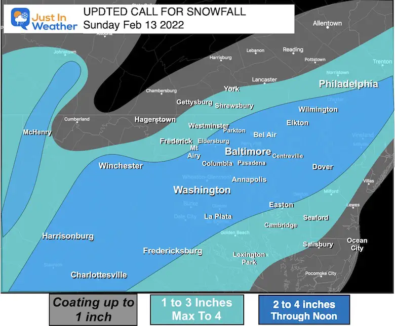
How Much Snow?
Compare My UPDATED Call for snowfall to NEW Computer Model Guidance
My UPDATED Call For Snowfall
Bust potential:
This has been trending to ‘overachiever status’. However, the location of the moderate snow band will make or break the totals. This will depend on the speed of that front. Faster, moves through soon. If slower, it will dump on some west, but leave out some east.
COMPARE TO
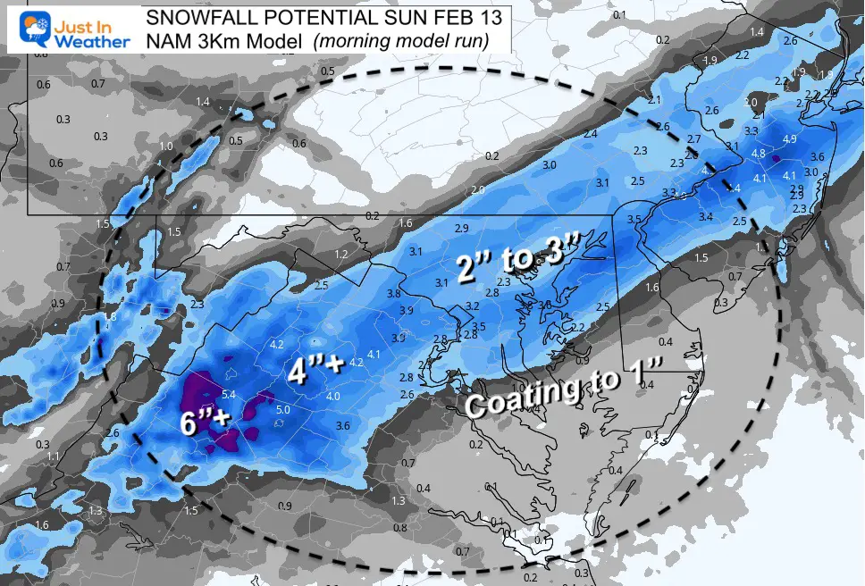
NAM = Moderate snow, but less for So MD/Delmarva.
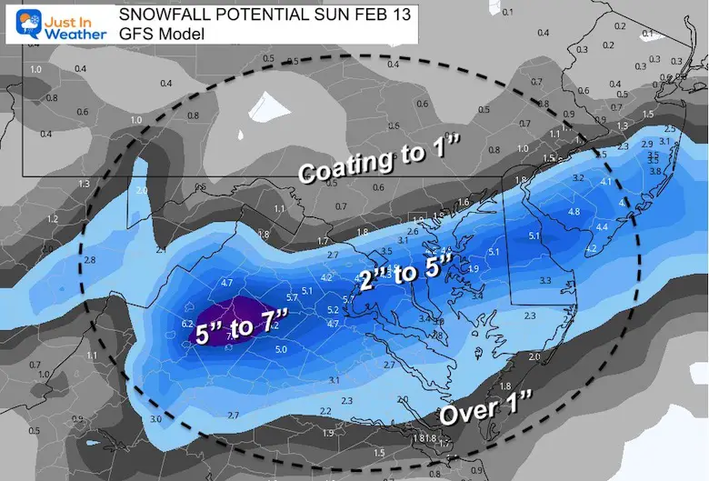
GFS = Highest but farther south
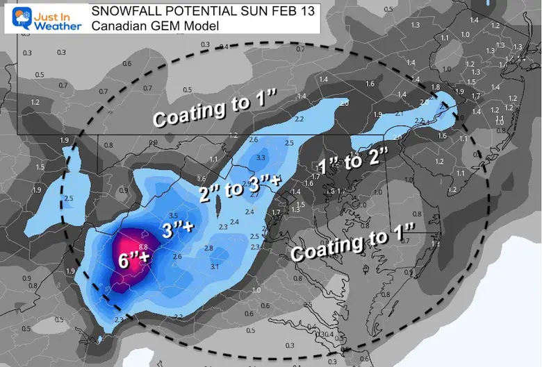
Canadian = Still farthest west with snow
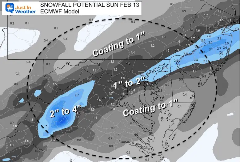
European = Still the lowest with total snow.
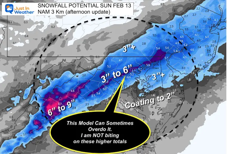
NEW NAM 3 Km (from this afternoon)
I believe this model has a tendency to overdo some events, which may be happening here.
That jump of 3” to 6” in metro areas is NOT what I support.
Compare the the prior Snow Plot
NEW NAM 3 Km (from this morning)
I highlighted that this was from the ‘morning model run’ because the afternoon run was even higher. I want to examine that before sharing later.
I am aware there are some spelling and grammar typos. I have made a few public statements over the years, but if you are new here you may have missed it:
I have dyslexia, and found out at my second year at Cornell. I didn’t stop me from getting my meteorology degree, and being first to get the AMS CBM in the Baltimore/Washington region.
I do miss my mistakes in my own proofreading. The autocorrect spell check on my computer sometimes does an injustice to make it worse.
All of the maps and information are accurate. The ‘wordy’ stuff can get sticky.
There is no editor that can check my work when I need it and have it ready to send out in a newsworthy timeline.
I accept this and perhaps proves what you read is really from me…