February 12 2022
Saturday Afternoon Update
The challenge with this weather event has been the phasing I described a few days ago. It is a delicate balance of energy, timing, and location where that will happen. This morning the guidance supposed some of that, but mainly this enhanced snow was due to a jet streak and slowing down of the front. That slow down has happened to us before, with us on the warmer side delaying icing. That busted two different morning forecasts.
This new info shows another delay, but this time supporting more snow development on our region. This is thanks to colder temps and enough time before sunrise to allow the ground to cool and support stickage.
My updated snow forecast comes with model support, which I will show you below. I am still hedging my bets a little lower than the potential to consider some melting and overzealous computer plots. There is still some more upside potential.
The main take away here is that it should snowing for much of the region on Sunday morning with impact on the roads.
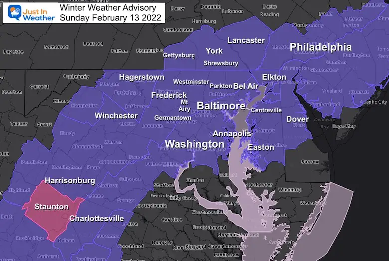
Winter Weather Advisory: Expanded
Other National Weather Service Offices have joined the party since my last report. This now includes Southern Pennsylvania and northern Delmarva.
These areas should see snow impacting morning travel which may include Church services and sports activities planned.
What may seem like an enhancement of this event, is actually just following what was originally expected a few days ago. It is NOT a major snow, but enough to impact travel. It is also going to be an abrupt change from the 60s, yet has support from cold enough air and timing before sunrise to counter the warm ground for stickage.
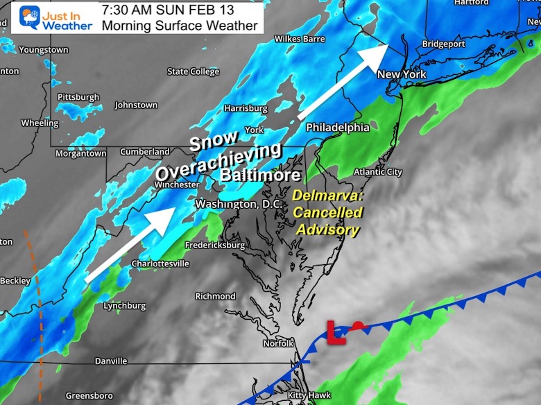
UPDATED SUNDAY MORNING
Click to see: What Went Right AND Wrong
Overachiever NW But Delayed Cold BWI and South
UPDATE: NEW POST SATURDAY NIGHT
Click here to see:

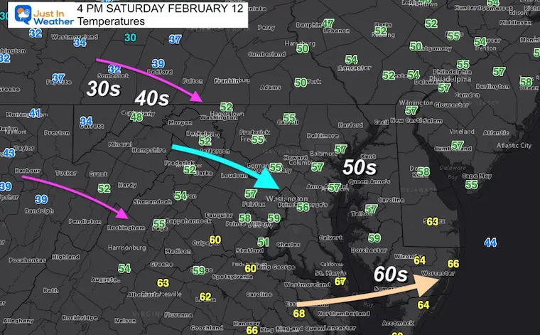
4 PM Temperatures
I am sure it’s crossed your mind that it is too warm for snow, or even for it to stick.
Baltimore’s BWI hit 60ºF at 3 PM, marking the 3rd day in a row at or above 60… But the cold air is on the way. It has all be factored in.
Temperatures Forecast
10 PM Sat to 12 PM Sun
Here is a quick look at the falling temps, that should reach and remain at or below freezing.
Notes:
Midnight to 1 AM: Freezing in Frederick, Westminster, and York PA
4 to 5 AM: Freezing in Baltimore, Aberdeen, Washington, and Annapolis.
This is enough time for the ground temps to sustain stickage before sunrise… Even if we allow a 2 hour delay of the cold.
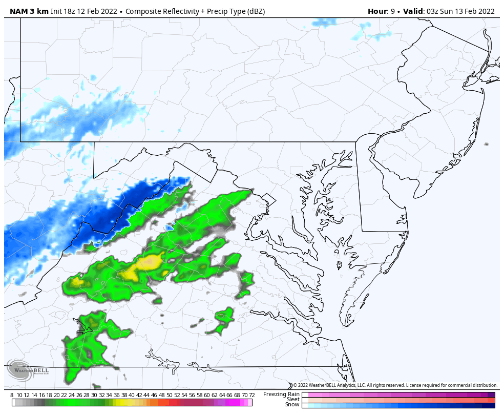
Snow Forecast Animation
10 PM Sat to 8 PM Sun
Notice this may begin with brief rain in metro areas, but turn to snow within an hour or two of midnight.
Snow will peak in the morning! The updated slows the band of snow down.
Do you recall the two morning events we expected a cold front and icing… but that didn’t happen? This was due to the front and freezing temps being delayed….
This time that delay appears to be over our region, enhancing the snow event.
(I will make an hourly timeline slider in my evening report to better track this)
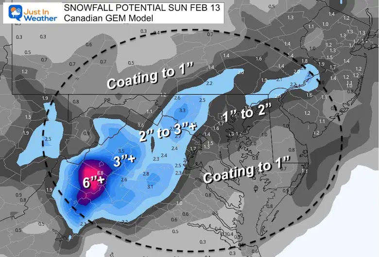
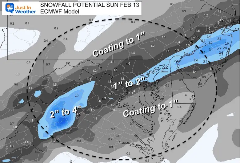
How Much Snow?
- Compare My UPDATED Call for snowfall to NEW Computer Model Guidance
- NAM = Moderate snow, but less for So MD/Delmarva.
- GFS = Highest but farther south
- Canadian = Still farthest west with snow
- European = Still the lowest with total snow.
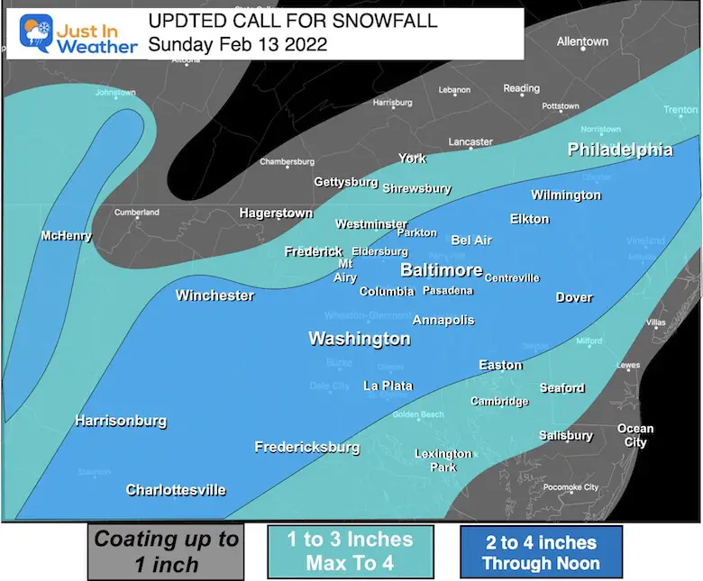
My UPDATED Call For Snowfall
Peak of this event should be at sunrise on Sunday morning…
Bust potential:
This has been trending to ‘overachiever status’. However, the location of the moderate snow band will make or break the totals. This will depend on the speed of that front. Faster, moves through soon. If slower, it will dump on some west, but leave out some east.
COMPARE TO
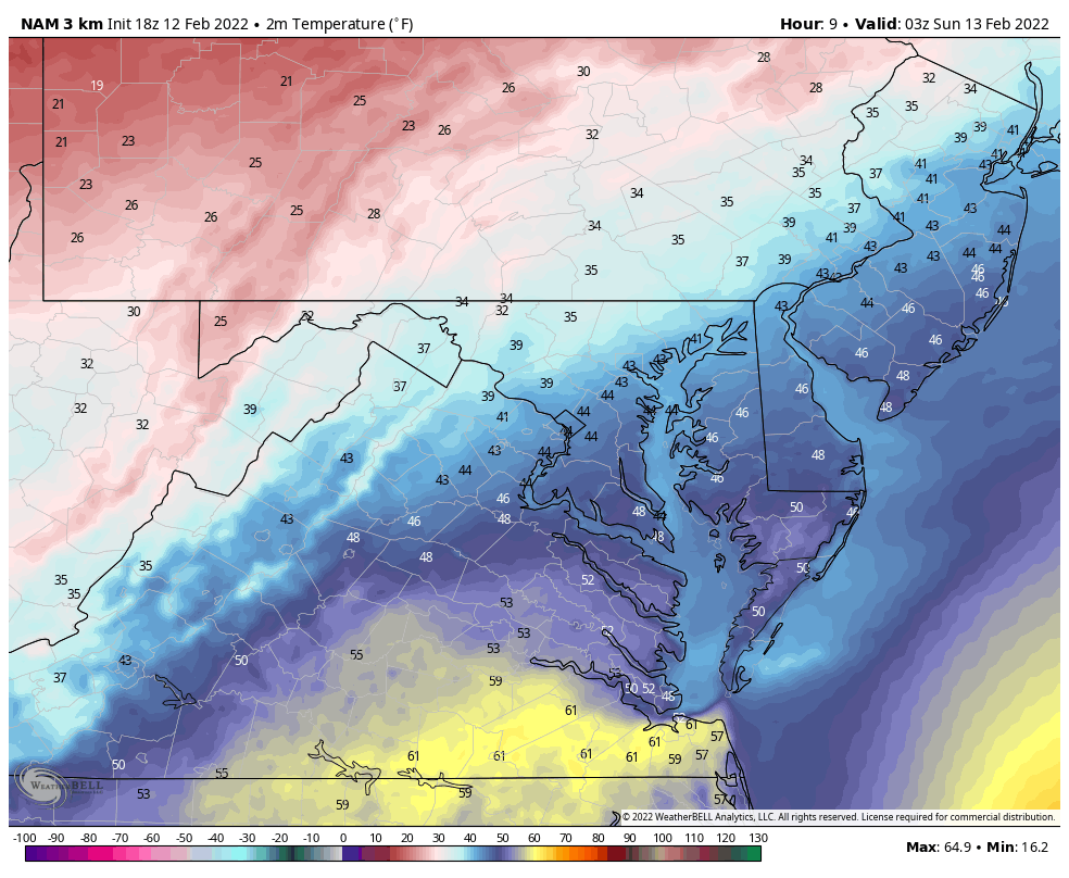
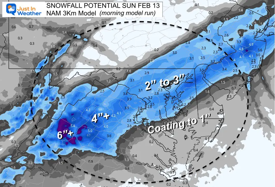
NAM 3 Km
I highlighted that this was from the ‘morning model run’ because the afternoon run was even higher. I want to examine that before sharing later.
Moderate snow, but less for So MD/Delmarva.
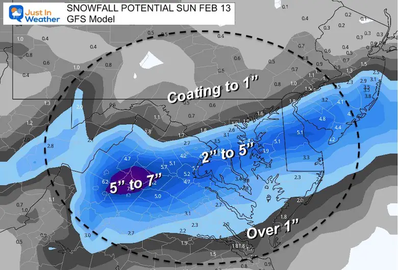
GFS Model
Highest in the snow banding, but farther south.
Canadian GEM
Still farthest west with snow.
European ECMWF
Still the lowest with total snow.
ALSO SEE
ALL FITF GEAR

FITF THUNDERSNOW


Winter Outlook Series:
My Call For Snowfall

Last Winter Recap: My Old Outlook And Your Grades Of My Storm Forecasts


Please share your thoughts, best weather pics/video, or just keep in touch via social media
*Disclaimer due to frequent questions:
I am aware there are some spelling and grammar typos. I have made a few public statements over the years, but if you are new here you may have missed it:
I have dyslexia, and found out at my second year at Cornell. I didn’t stop me from getting my meteorology degree, and being first to get the AMS CBM in the Baltimore/Washington region.
I do miss my mistakes in my own proofreading. The autocorrect spell check on my computer sometimes does an injustice to make it worse.
All of the maps and information are accurate. The ‘wordy’ stuff can get sticky.
There is no editor that can check my work when I need it and have it ready to send out in a newsworthy timeline.
I accept this and perhaps proves what you read is really from me…
It’s part of my charm.
#FITF


