


May 8 After Morning Storms Summer Heat This Afternoon
Wednesday, May 8 Morning Report This morning, a line of thunderstorms developed across central Pennsylvania to parts of north central Maryland. This is part of a trough in the atmosphere,…
February 8 2022
Tuesday Night Update
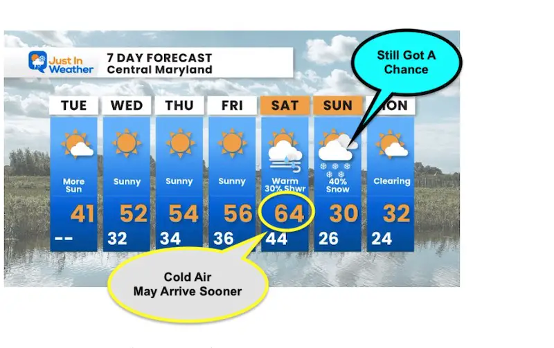
Stop me if you heard this before: We have a warm up on the way, followed by and arctic front and snow. It seems like the them of this winter, and it doesn’t always play out. This time there will be a buffer to allow the cold air to establish first.
Before we get started, I just want to reinforce that we are still en route to a quiet weather week. It will feel like Pre-Spring with sun and temps pushing the 50s.
I am expecting a peak into the 60s on Saturday and then the bottom falls out with a chance for snow.
This is NOT a forecast for snow, but I am sharing the support and why I think the chances are improving. We are 5 days away and it is Super-Bowl Sunday, so I just want you to have all the info possible for any alternate plans.
Saturday High Temperatures
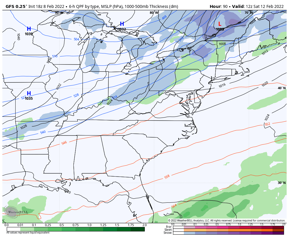
If you saw my morning forecast yesterday, I pushed the 64ºF high in for Baltimore, followed by a 40% chance for snow on Sunday.
Well, based on what I am about to show you, that Saturday number may need a correction, but the Sunday snow has more support.
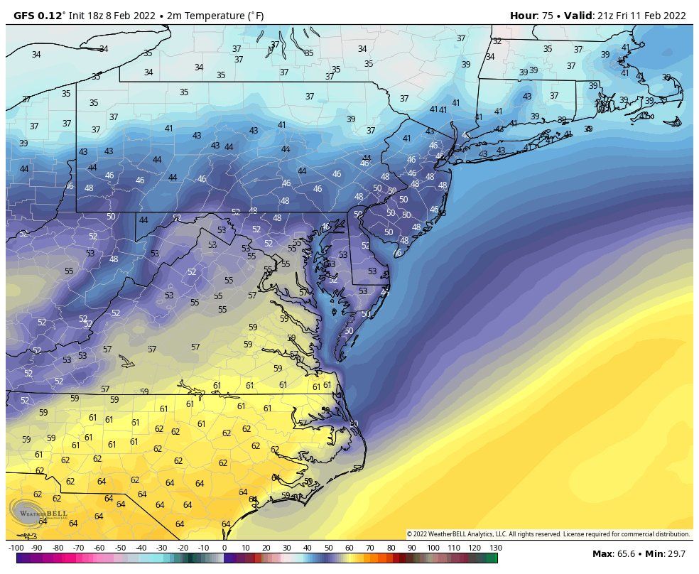
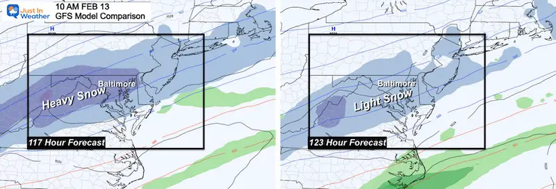
IF we follow the GFS Model (which I am in this report), then timing is everything. It is now speeding up the cold front by a few hours, which would reach Baltimore BEFORE having the chance to reach the 60s… BUT they still have ‘a go of it’ in southern Maryland.
Animation Forecast: 4 Pm Friday to 4 Pm Sunday
Saturday
If the new GFS timing is correct, Baltimore will reach the 50s in the morning, but drop in the afternoon. The 60s have a better chance in southern Maryland and Lowe Delmarva. If the front slows a few hours, then BWI will have that run for 60ºF.
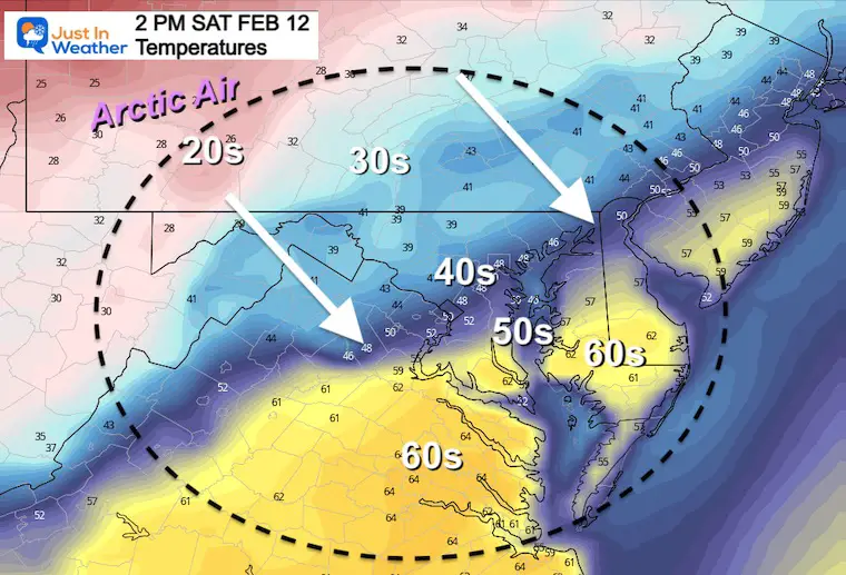
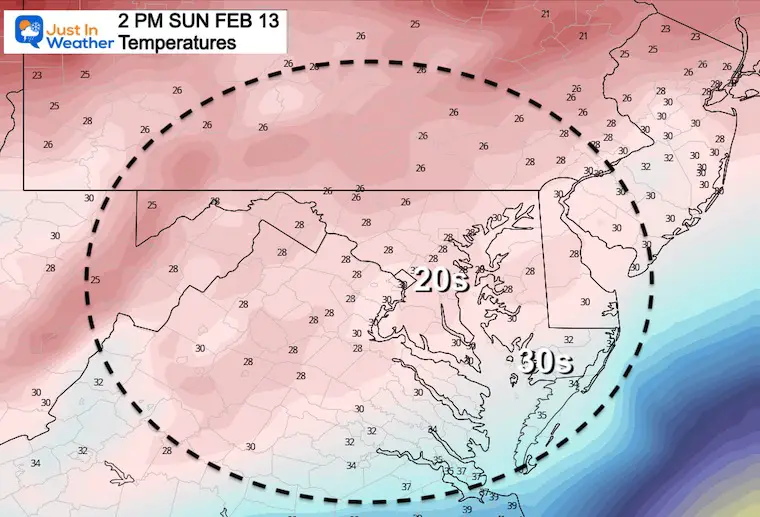
The Arctic Air will settle in Sunday with the freezing line near the beaches. Most of Maryland (west and north) hold in the 20s.
By the way, we had snow on Super Bowl Sunday on Jan 30, 2000. Anther La Niña Year. I remember because I was driving a moving truck in Owings Mills with 4 bald tires. That kind of thing will scar you.
We had above normal snow that year, with 3 snow events between Jan 20 and 30. This included the 14” and thunder-snow surprise storm on Jan 25th.
Comparing the Afternoon (left) to the Morning (right) model runs, we can see a but if an enhancement in the expectation. But, wait…
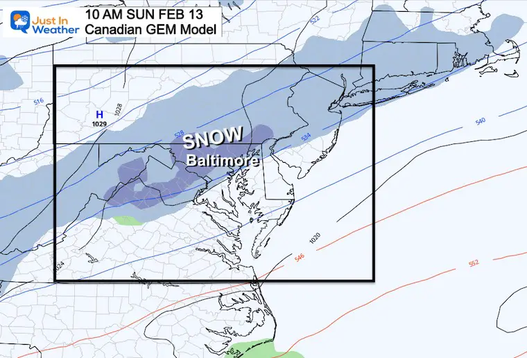
Our long range leader is a NO!
This adds complexity as it is not shown here… yet. Now it introduces more questions about validity or not.
I have relied on this Canadian Model being the best performing with ‘Arctic Air’ since 2014.
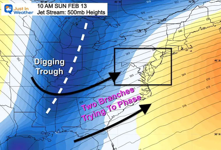
If we give the GFS another opportunity to prove itself, let’s explore what it is trying to develop.
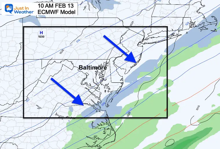
Here is a digging trough for the eastern US AND the fact that the model guidance ‘did not’ show phasing, yet.
This shows the upper level energy catching up to the coastal front. It is not phasing yet, but closer to doing so. That establishes a weakness in the atmosphere for a band of snow to develop.
Not truly phasing, but leaning that way actually gives me more reason to believe something will develop.
Why? Because many systems, including the rain/ice yesterday was because of a coastal Low tracking ‘west’ of the model plots.
If we project that same bias for this weekend, that increase the chance for ‘phasing’ and developing snow.
Here we see the attempt to phase the two branches of the jet steam. The initial band of snow over our region on Sunday morning is far from the Low Pressure. The enhancement would be along the back side of the arctic front with a jet streak.
The true phasing would be offshore.
But, if the bias of that western trend shows up again, then we may have a storm closer to the coast worth watching.
Last month I showed two events where the GFS won, but it was not perfect. We still need to assess all model guidance and identify the strengths to focus on.
Again, this is NOT A PROMISE FOR SNOW! I am showing you what I and other meteorologists are looking at this week. So when it gets mentioned again, we can compare any trend towards or away from this developing.


Last Winter Recap: My Old Outlook And Your Grades Of My Storm Forecasts


*Disclaimer due to frequent questions:
I am aware there are some spelling and grammar typos. I have made a few public statements over the years, but if you are new here you may have missed it:
I have dyslexia, and found out at my second year at Cornell. I didn’t stop me from getting my meteorology degree, and being first to get the AMS CBM in the Baltimore/Washington region.
I do miss my mistakes in my own proofreading. The autocorrect spell check on my computer sometimes does an injustice to make it worse.
All of the maps and information are accurate. The ‘wordy’ stuff can get sticky.
There is no editor that can check my work when I need it and have it ready to send out in a newsworthy timeline.
I accept this and perhaps proves what you read is really from me…
It’s part of my charm.
#FITF