


May 12 Mothers Day Showers And Another Aurora Viewing Tonight May Be Better
Sunday May 12 Mother's Day Morning Report Today, we focus on the all-important Mother’s Day weather and the ongoing impact of the latest Solar Storm. We have been stuck in…
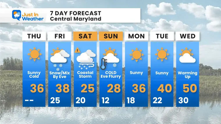
Thursday January 27 – Morning Report
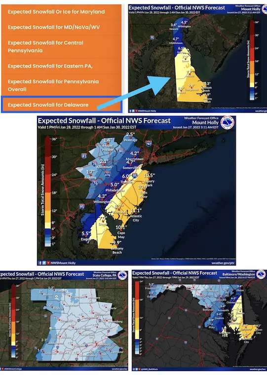
The upcoming Nor’easter is expected to bring the biggest impact to the coast. So, with more snow and wind farther east, it is no surprise that the first alerts issued is a Winter Storm Watch across Delmarva (The Delaware – Maryland – Virginia peninsula).
Since there was some confusion in my last report showing a local NWS snow map, there is EXTRA ATTENTION below for Delaware, as well as coastal Maryland to New Jersey.
This is for areas most likely to have snow OVER 5 inches AND Strong Winds between 30 to 45 mph (near blizzard conditions)
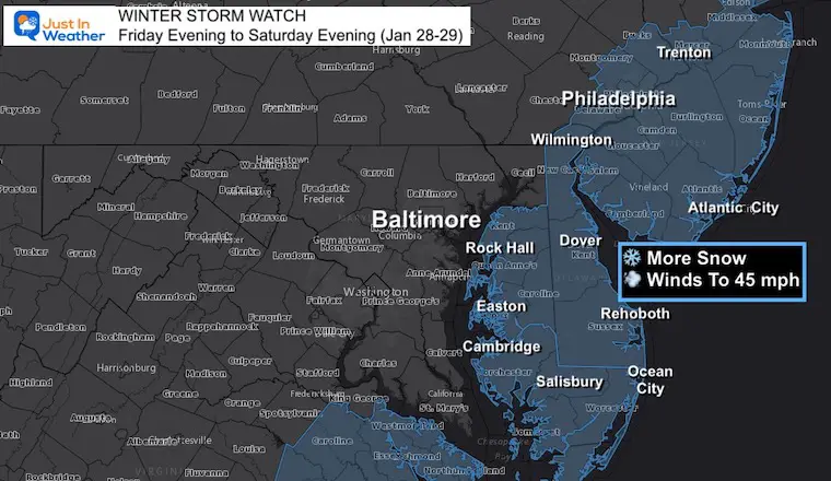
This has always been a ‘more snow East’ event. Your area will be lucky to be invited to the party. There is lots of info below.
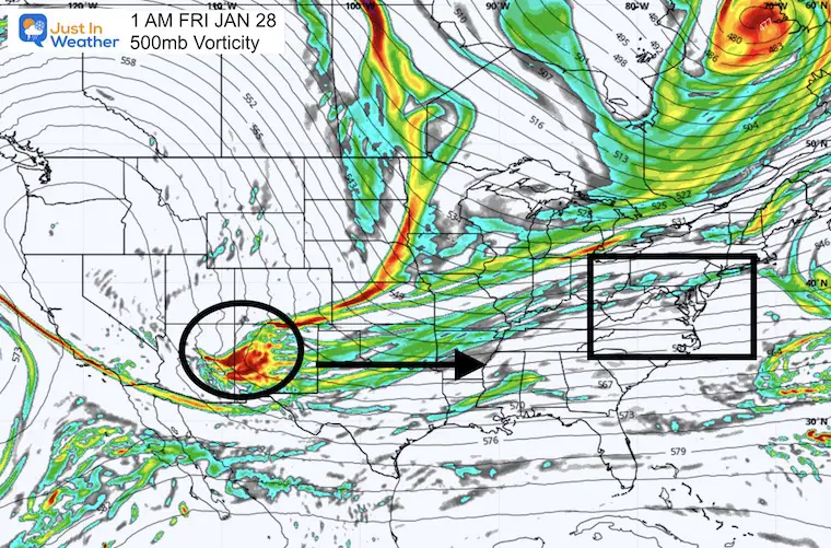
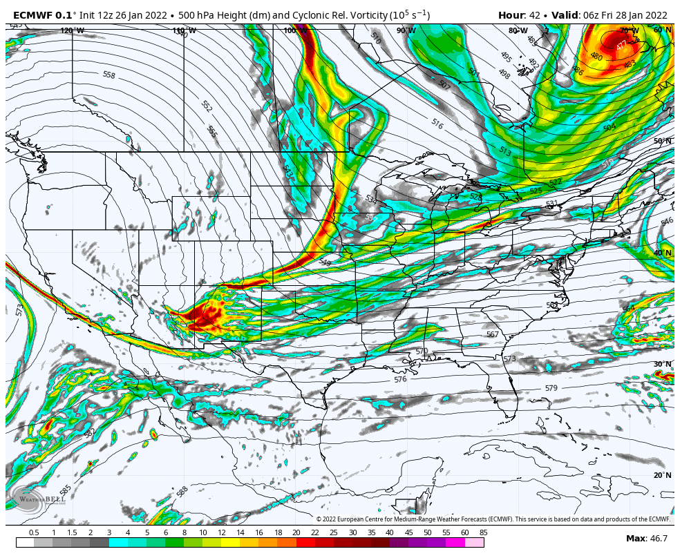
The prime energy is entering the west coast now. While there was a shift a little east in the overnight modeling, the next model package this morning will be much more reliable.
I will post my Winter Snow Map in my next report.
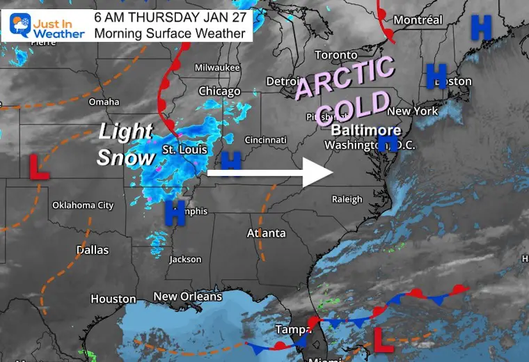
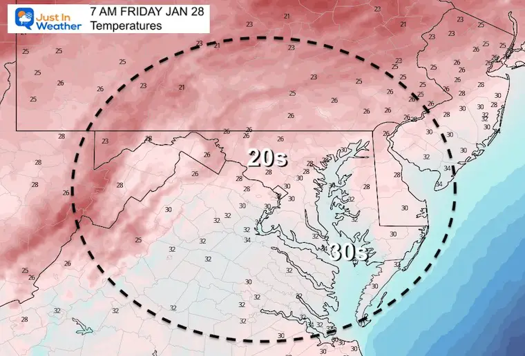
Arctic air is fully in place now.
The first piece of energy for our storm is showing up with a cluster of light snow around St. Louis. This is what we will watch to arrive Friday afternoon/evening.
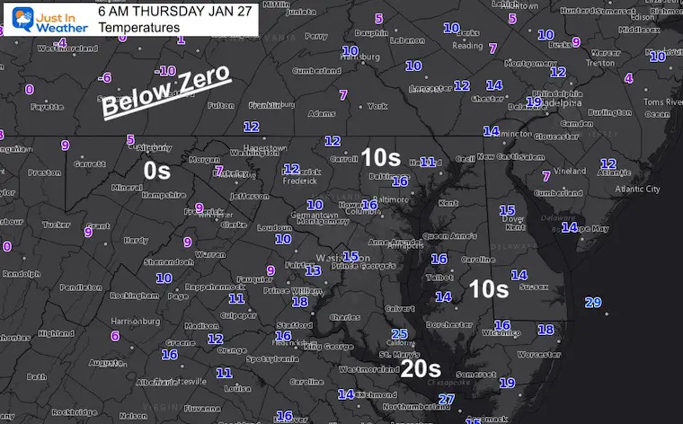
Coldest Morning in 3 years!
BWI did report 14ºF briefly. If validated, that would beat the three days we hit 15ºF this month (Jan 4, 16, and 22). We have to go back to Feb 2, 2019 for the next coldest morning at 8ºF.
Weather Almanac: Climate Data
TODAY January 27
Normal Low in Baltimore: 25ºF
Record 3ªF in 1987
Normal High in Baltimore: 42ºF
Record 72ºF 1974
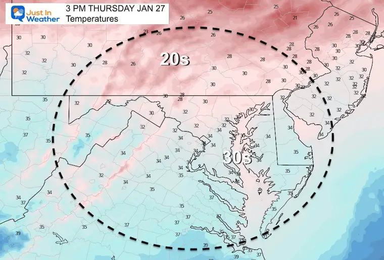
Morning
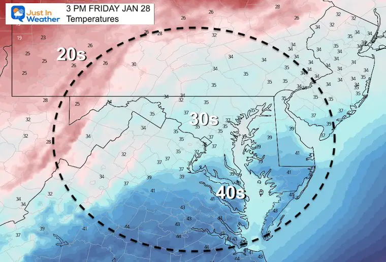
Afternoon
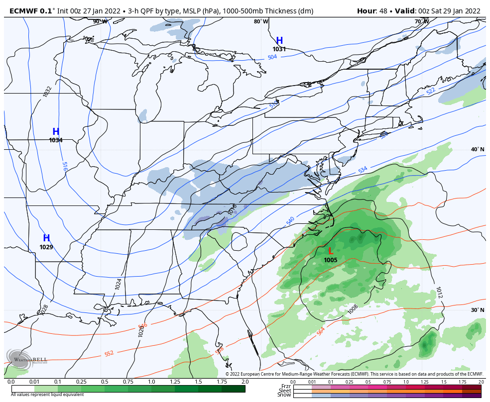
Storm Development
From my prior report:
The Upper Level Energy (around 18,000 Ft high) will be in New Mexico early Friday morning. This will race to the east coast by Saturday morning, but will it be fast enough. That is the true key because Saturday morning is when the coastal Low will actually form.
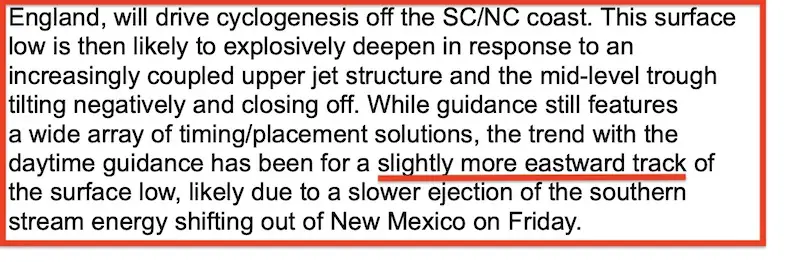
The NOAA Weather Prediction Center discussion earlier today included this nugget I clipped for you. They have also identified a trend for the storm to toggle farther east. That would mean less snow if this energy from New Mexico is SLOWER.
1 AM Fri to 1 AM Sat
If you want a big storm, you want this energy from New Mexico to the East coast to speed up (even more)… This animation shows how fast that will already be. Nearly 2,000 miles in 24 hours. So going faster is asking a lot!
MAPS
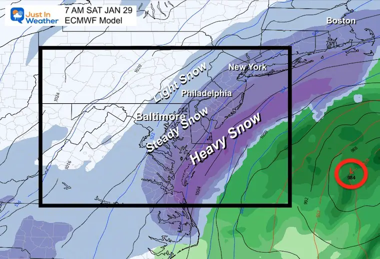
ECMWF Model
Animation 7 PM Friday to 7 Pm Saturday
This is still the strongest and closest display, but it has shifted a little east.
MY THOUGHTS:
Last week’s arctic front busted metro snow because it developed a little east. There is also Atmospheric Memory setting up the track east as well. However, that recent event did pull a little west at the very end, when DE got added to the Advisory late and snow reached Rehoboth.
So we are threading the needle on the fringe of steady snow over densely populated areas. Patience is needed until get the morning model package to try and firm up any legit calls.
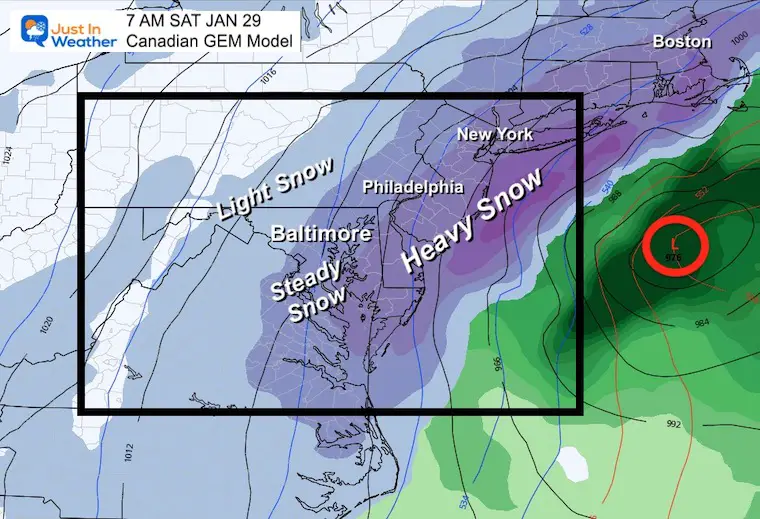
Bigger Impacts West – European and Canadian have the steady snow very close to Baltimore and I-95 areas.
European Model
Canadian Model
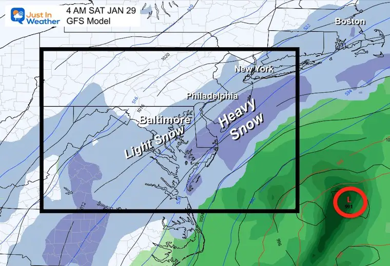
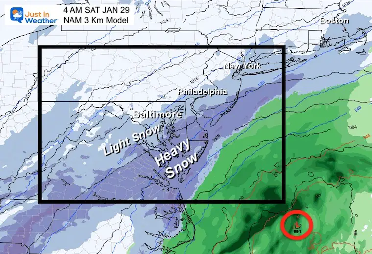
Farther East/Coastal Focus – GFS and NAM both have the fringe back edge farther east, with the impact still on Delmarva and the coast.
(Note these plots are a few hours easier due to system pulling farther away)
GFS Model
NAM Model
*In my last report, Delaware felt snubbed when I showed the NWS map for just Maryland. I have much love for The First State!
FITF – You may win again with snow.I have a page dedicated to all local office snow maps. Click the image and keep it handy. It will update when they post a new map.
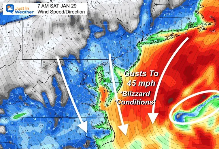
The strong winds will develop Saturday morning through afternoon. While New England may get a full out blizzard, those conditions may be felt at times along our coast.
Blizzard Definition: Winds 35 mph with snowfall rates 1”/Hr sustained for 3 hours.
“Conditions” reach that criteria for les amount of time
My first call for snowfall map will be issued a little later today in my next report
Faith in the Flakes…
Based on Baltimore at BWI
Bitter cold will follow this storm, then we have a chance to possibly reach 50ºF or higher by the end of next week.
*Disclaimer due to frequent questions:
I am aware there are some spelling and grammar typos. I have made a few public statements over the years, but if you are new here you may have missed it:
I have dyslexia, and found out at my second year at Cornell. I didn’t stop me from getting my meteorology degree, and being first to get the AMS CBM in the Baltimore/Washington region.
I do miss my mistakes in my own proofreading. The autocorrect spell check on my computer sometimes does an injustice to make it worse.
All of the maps and information are accurate. The ‘wordy’ stuff can get sticky.
There is no editor that can check my work when I need it and have it ready to send out in a newsworthy timeline.
I accept this and perhaps proves what you read is really from me…
It’s part of my charm.
#FITF


Last Winter Recap: My Old Outlook And Your Grades Of My Storm Forecasts


