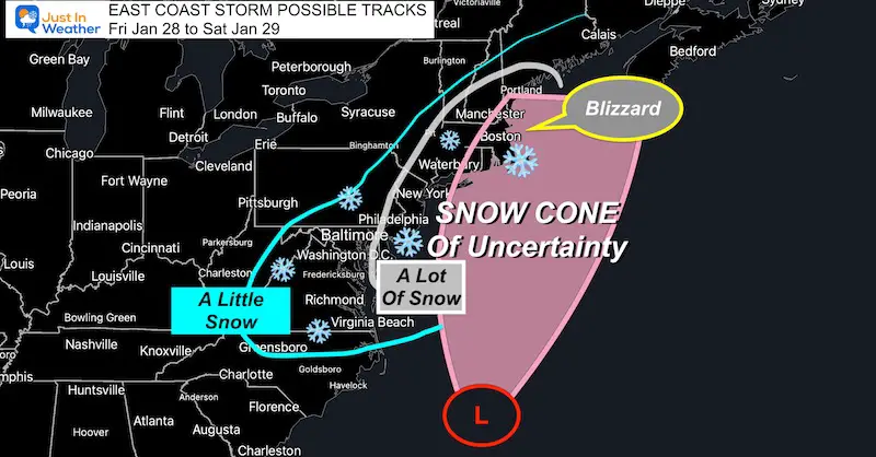
As the clock ticks closer to the weekend coastal storm, we are getting a little more confidence in how it will behave. But there is still room for this to Boom or Bust! The information I share below is to invite you in on what I am looking at. I do have confidence in the initial snow, and the window of opportunity is still open for the main coastal storm Saturday.
I can hear the jokes and see the memes already (snow range of 0″ to 64″). However, this storm will drop a lot of snow on its main path, and the edges will have a sharp drop of. So a small change in the track will make a big difference.
The basic idea is that there will be more snow East! In this case, thanks to the cold air, our region will be all or mostly snow. That means the top totals in the Mid Atlantic may be at the beaches. The storm will crank Blizzard Conditions for Eastern New England on Saturday.
There are two parts to this storm. The first on Friday will bring light snow to most of the region. The second part will be the coastal storm forming overnight into Saturday.
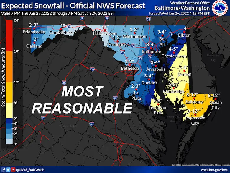
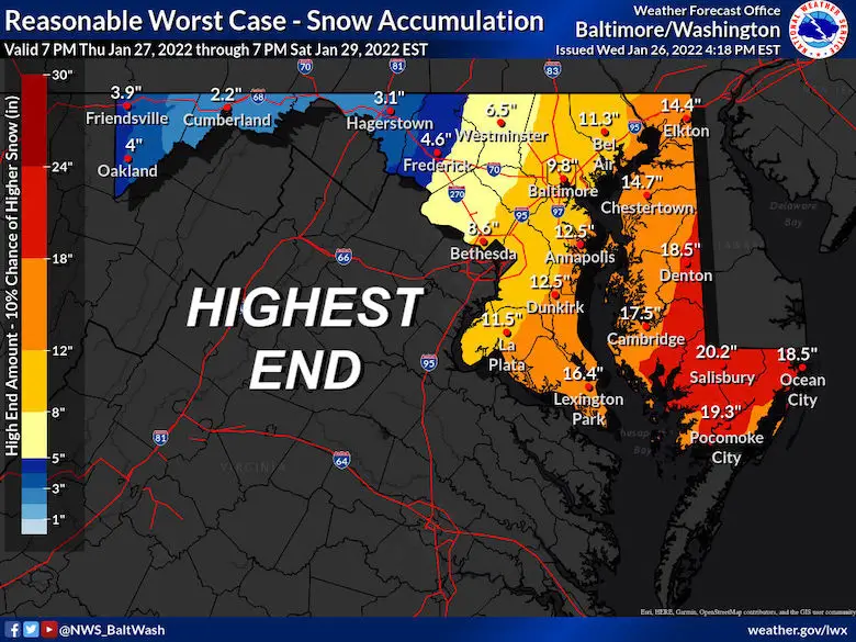
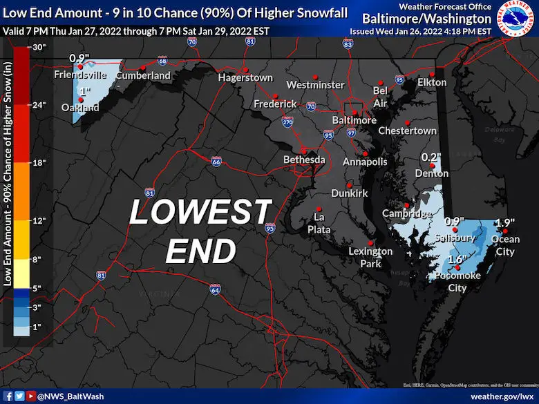
I will show you two models maps below that highlight this. Also, the snow potential for Over 4 inches. Finally,the NWS snow forecast range for Maryland that shows a wide spread potential.
My First Call For Snowfall Map will be issued tomorrow (which is my standard practice)
Boom or Bust
Forgive me for repeating myself, I just can’t state this enough: We are trying to plot snow for a storm that has not yet formed. Any shift in the location it develops and then the track still can dramatically change the snow totals..
My Snow Cone Of Uncertainty is designed to show the heavy snow region hugging the coast. But any shift cantering heavier snow westward or out to sea.
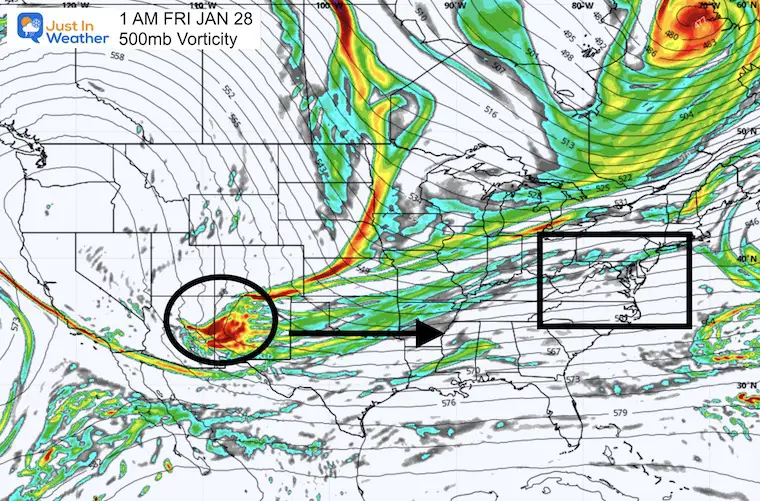
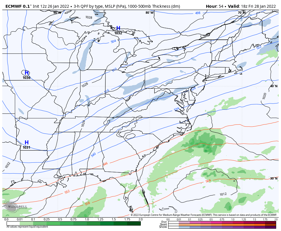
Storm Set Up: Jet Stream Vorticity
The Upper Level Energy (around 18,000 Ft high) will be in New Mexico early Friday morning. This will race to the east coast by Saturday morning, but will it be fast enough. That is the true key because Saturday morning is when the coastal Low will actually form.
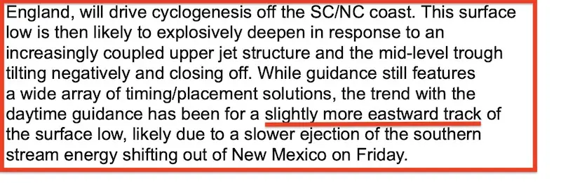
WPC Discussion
The NOAA Weather Prediction Center discussion earlier today included this nugget I clipped for you. They have also identified a trend for the storm to toggle farther east. That would mean less snow if this energy from New Mexico is SLOWER.
Vorticity Animation
1 AM Fri to 1 AM Sat
If you want a big storm, you want this energy from New Mexico to the East coast to speed up (even more)… This animation shows how fast that will already be. Nearly 2,000 miles in 24 hours. So going faster is asking a lot!
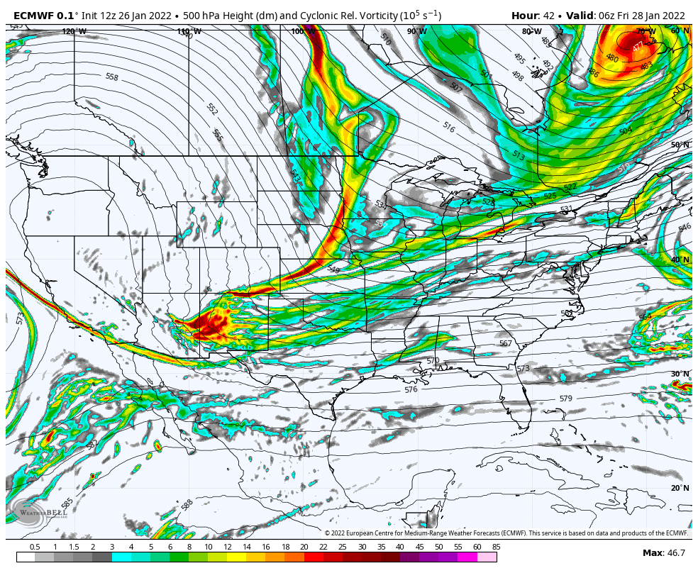
Storm Development (ECMWF)
This is the model that has that energy faster resulting in the storm developing a little closer to the coast…
Watch the right side of the window, and the red L. This European Model has shifted a little farther east from yesterday’s run.
Comparing Models
I’ve plotted the timelines form the European and GFS Models together so you can compare.
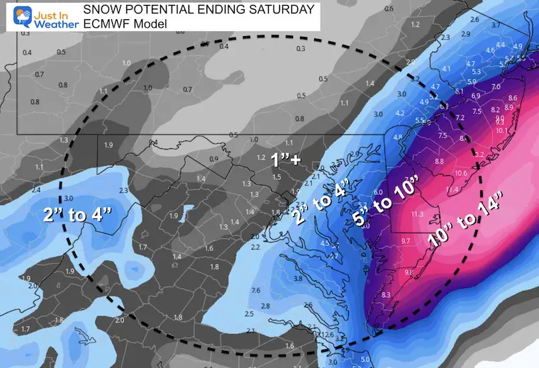
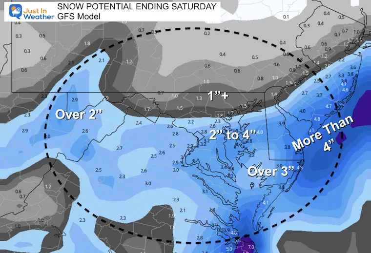
The Euro is closer to the coast, and brings in more snow… The GFS is farther east with the storm. It has less snow.
See a few Snow Total Forecast Maps below
ECMWF Model (more snow) —-> slider
4 PM Friday to 7 PM Saturday
This is a longer time frame with a stronger and longer impact bringing the storm closer to the coast.
A shorter time frame for snow, and less heavy snow based on a track farther east.
january-26-weather-snow-storm-gfs-friday-pm-4
january-26-weather-snow-storm-gfs-friday-pm-7
january-26-weather-snow-storm-gfs-friday-pm-10
january-26-weather-snow-storm-gfs-saturday-am-1
january-26-weather-snow-storm-gfs-saturday-am-4
january-26-weather-snow-storm-gfs-saturday-am-7
january-26-weather-snow-storm-gfs-saturday-am-10
january-26-weather-snow-storm-gfs-saturday-pm-1
Snow POTENTIAL Forecasts
This is the spread or range that still seems logical. Again, this will be made or broken based on the location the coastal storm forms on Saturday morning, and the tracks.
If you want more snow, you want the Euro to verify with this closer to the coast.
There are many other models, and I will begin to show them in my reports on Thursday.
Euro (Higher End)
GFS (Lower End)
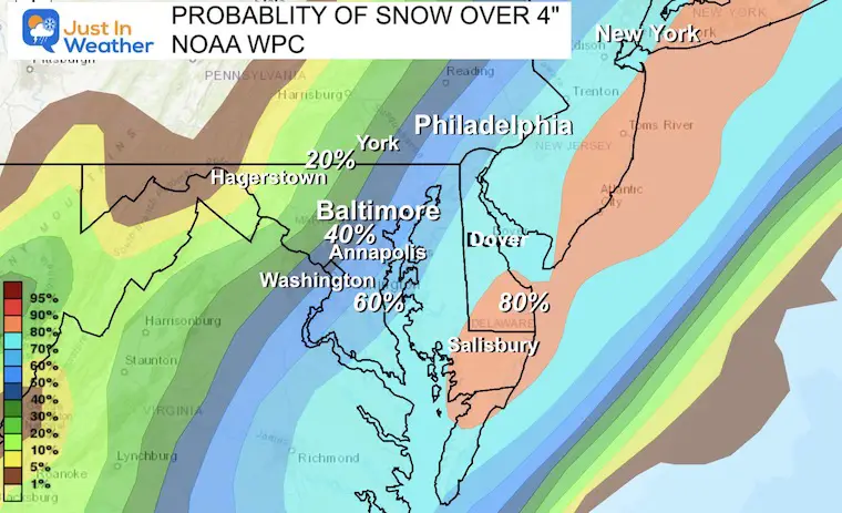
Snow Over 4 inches? Potential Odds
It’s best to use a blend of the models (including others I have not shown), to get a better idea of what we may expect.
Here we see high chance for over 4 inches of snow in Southern Maryland and across Delmarva to the beaches.
Less snow to the west, but the door is still open (lower odds) for a westward shift.
Storm will spread across most of our region Friday afternoon.
Light Snow through Friday evening. 1 to 3 inches in metro Baltimore very possible. (My snow map will be issued Thursday)
Highest snow totals all be farther east and near the beach, less snow west.
Big Snowstorm for New England Saturday.
Still Question:
Delmarva gets a moderate or major snow , but how much???
Saturday Morning: If storm is closer, then snow will last into the afternoon and much more snow may fall. May also bring more snow farther west.
I will be updating often on Thursday.
Faith in the Flakes
*Disclaimer due to frequent questions:
I am aware there are some spelling and grammar typos. I have made a few public statements over the years, but if you are new here you may have missed it:
I have dyslexia, and found out at my second year at Cornell. I didn’t stop me from getting my meteorology degree, and being first to get the AMS CBM in the Baltimore/Washington region.
I do miss my mistakes in my own proofreading. The autocorrect spell check on my computer sometimes does an injustice to make it worse.
All of the maps and information are accurate. The ‘wordy’ stuff can get sticky.
There is no editor that can check my work when I need it and have it ready to send out in a newsworthy timeline.
I accept this and perhaps proves what you read is really from me…