January 14 Winter Storm Forming And First Watches Issued
Friday January 14 2022
This morning the start of the winter storm is showing up in the US on the weather map, but it will be taking a long scenic route to the southern states then our way Sunday. We will have widespread travel impact for the first few hours across our region. That will be mid Sunday afternoon to evening. It will be at night when the ice and rain will expand our way.
The good news is that more solid information with this ‘on the grid’ now had the main models in agreement. I have NEW COMPARISON maps below.
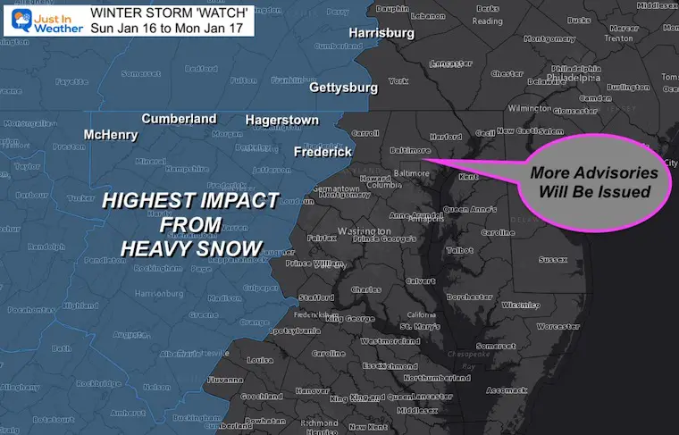
Winter Storm Watches have been issued for the areas expected to have mostly snow and the highest impact. There will be more ‘advisories’ added! We will see a wide range of snow, ice, and strong winds into Monday.
Morning Set Up
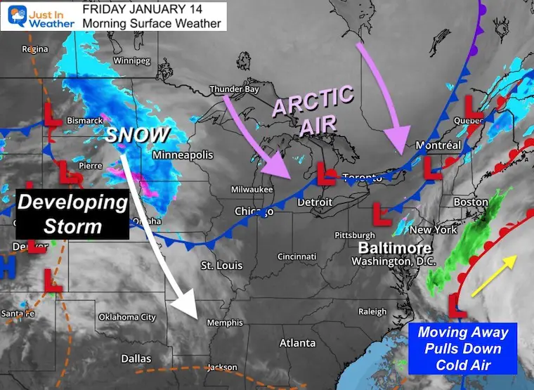
Surface Weather
Snow has expanded across the Dakotas, Minnesota, and Iowa. Low Pressure will develop and drop south. New plots of the path below..
Off the east coast is another storm missing us. But it will pull in stronger winds that will help drag down the arctic air from eastern Canada later today and tomorrow.
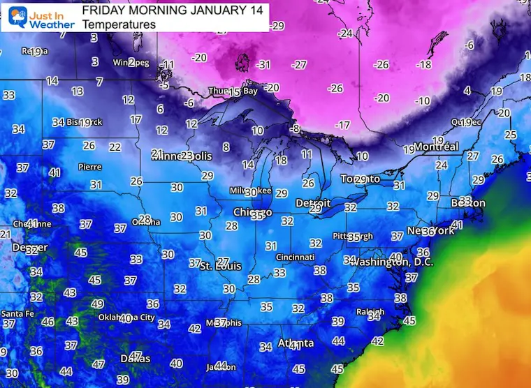
Temperatures
Check out the source of that Arctic Air in Canada. Wow!
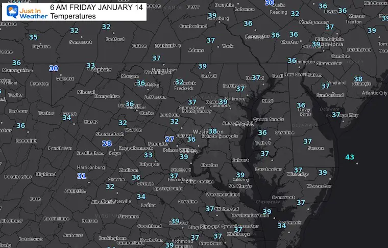
Local Temps
It’s not that cold to start our day. We will have mild weather ahead of the storm.
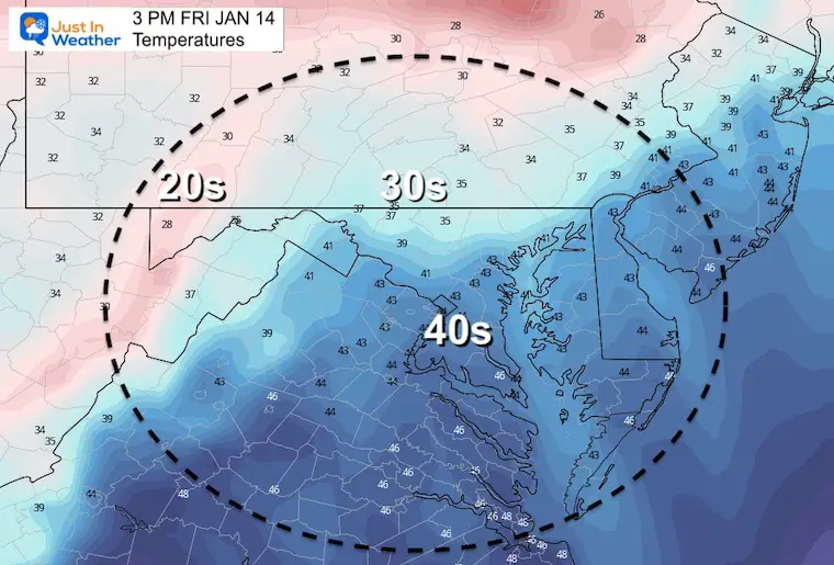
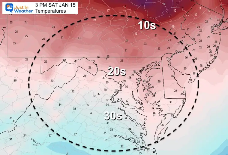
Afternoon Temperatures
Mild temps actually near ‘normal’. With increasing winds, it will eel chillier than yesterday.
Weather Almanac: Climate Data
TODAY January 14
Normal Low in Baltimore: 24ºF
Record -2ºF in 1912
Normal High in Baltimore: 41ºF
Record 79ºF 1932
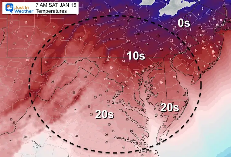
Saturday Temperatures
Morning
Afternoon
Looking Ahead: Winter Storm
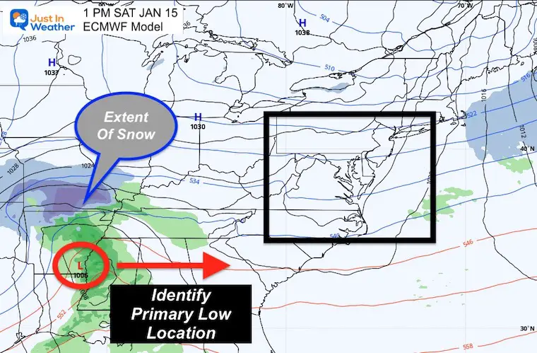
Saturday Set Up
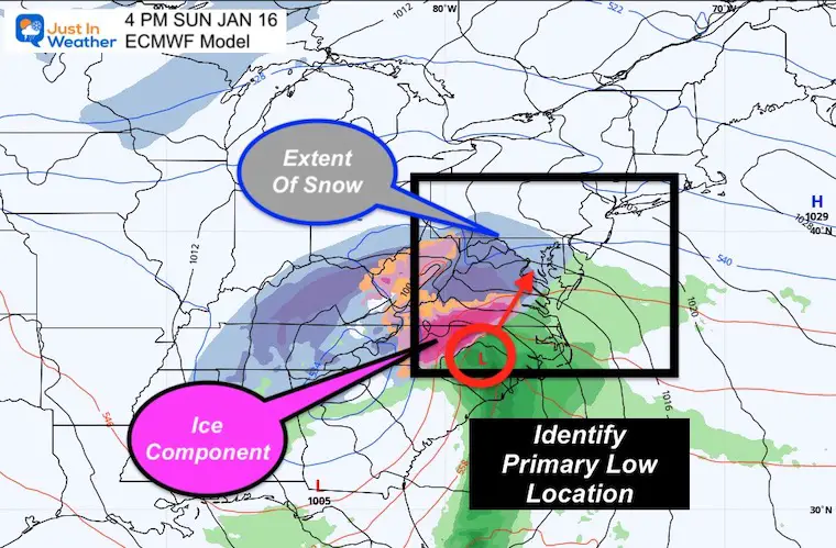
The latest forecast plot shows the Low Pressure in southeast Arkansa at 1 PM. This is a location I will be watching for verification. Slight adjustments of time or location of that Low is a big part of the eventual track and snow/rain line for us Sunday.
European Model Animation:
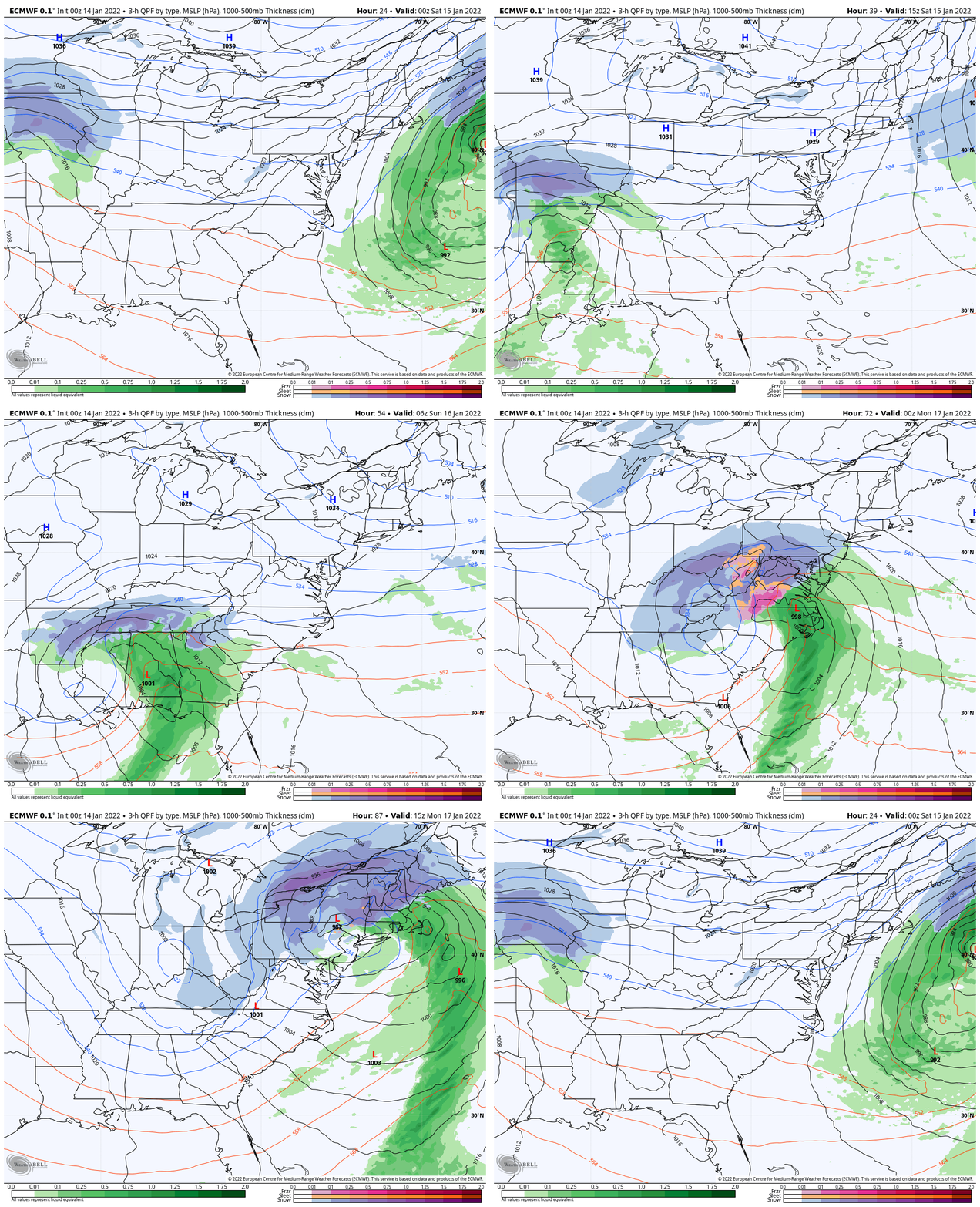
Sunday Afternoon
Plan for snow arriving in our region between 2 PM (south) to 6 PM north. Once it arrives, it will become heavy quickly.
This will help tell us how extensive that arctic air is, which will be tough to budge. The ice storm in the Carolinas may be more of an issue into the Mid Atlantic if the cold hangs longer.
The track of this Low AFTER turning the corner up north is when anexpected snow/rain line will be more confident. That is due to knowing the track of that storm path when in our direction.
Model Comparison
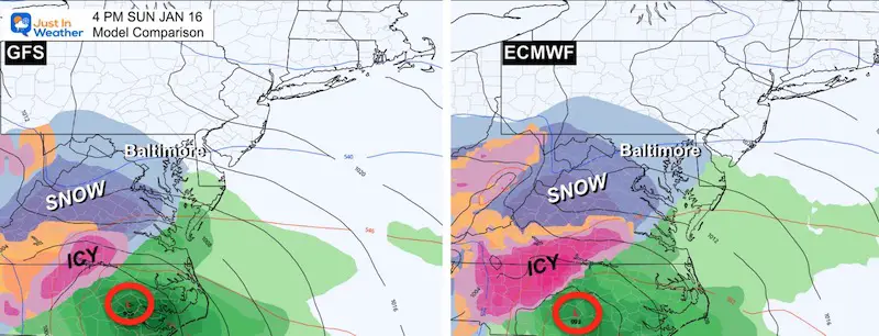
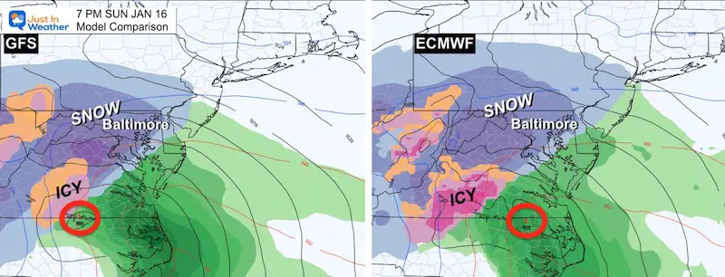
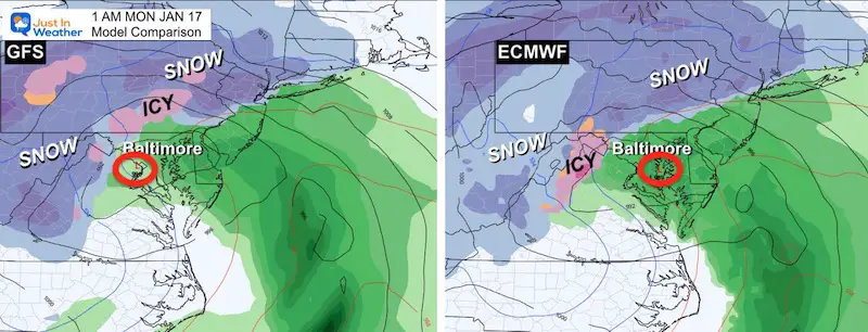
The GFS and European Models are very close with the storm plot. Still some subtle differences. Seeing this similarly now helps support the data ingested has been reliable.
There are still subtle differences.
There is still a chance for a shift 50 to 100 miles that can dramatically adjust expected snow totals.
Sunday Afternoon
Sunday Night
Monday Early Morning
Still a difference of Low location by about 50 miles, and where the impact snow will still be falling.
Winter Storm Watch: National Weather Service
Highest Impact Zones With Most Snow
These are areas most likely to get OVER 6 inches of snow. The places that stay all snow in the mountains will get over 12 inches of snow.
This will be upgraded to a WARNING when within 24 hours of the start.
Many more areas will still get advisories issued for lower snow, and even wind impacts as we get closer.
My Storm Expectations
Still the same.
I will post my First Call For Snowfall Map today.
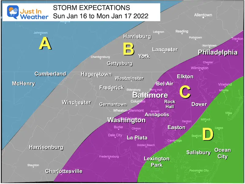
Regions
A:
Most likely all snow. Totals where that happens can easily be over 10 inches.
B:
Colder with more snow and sleet for longer.
Moderate totals until change over. Impact Sunday evening and night.
Still potential to mix to rain overnight.
Transition region! Slight change in track will determine a lot more or less snow.
C:
Starts as snow Sunday afternoon to evening. Faster Change over to rain, perhaps by midnight.
Rain Monday morning, may end with some snow showers.
D:
Most likely all rain and strong winds.
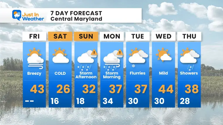
7 Day Forecast
Weather posts straight to your inbox
Sign up and be the first to know!
ALSO SEE
What is Faith in the Flakes: History of December 5th Snow
ALL FITF GEAR
FITF THUNDERSNOW
Winter Outlook Series:
Last Winter Recap: My Old Outlook And Your Grades Of My Storm Forecasts
Winter Weather Page – Lots of resources
Solar Cycle Increasing Sunspots Suggests More Snow
Comparing 4 Different Farmer’s Almanacs: Majority colder winter outlook than NOAA
NOAA Winter Outlook- But Read The Fine Print
Signals For Early Start To Winter In November
Winter Outlook Series: La Nina Double Dip
Nor’easters May Give Hint For Winter La Nina Pattern
Winter Folklore Checklist


