


Severe Storm And Flood Update Monday Afternoon July 14
Monday Afternoon July 14, 2025 The atmosphere is still very juicy! Dew points are high in the mid-70s, which means there is a lot of moisture in the atmosphere to…
Thursday January 13 Evening Update
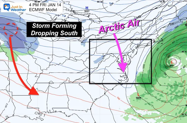
The complication with this weekend winter storm is something I have been trying to break down in simplest form. I see the storm in parts, and each one will help us compare to model plots for the progress in direction and eventual track into our region.
Once we get into Friday, the storm will take form in the Northern US and be ‘on the grid’. That is when the accuracy of the modeling will improve dramatically. Then we will watch for keep locations along the way that will give hints on the eventual impact on us.
The good news is that there is already better agreement, but I still see some wiggle room downstream, which could still adjust the tack enough for some of our region to adjust snow expectations.
Click to View: Storm On The Map: First Winter Storm Watches Issued
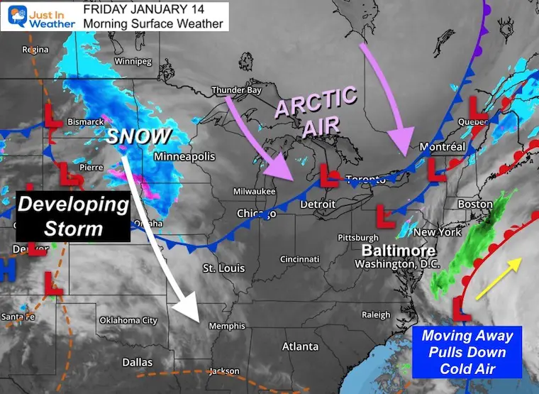
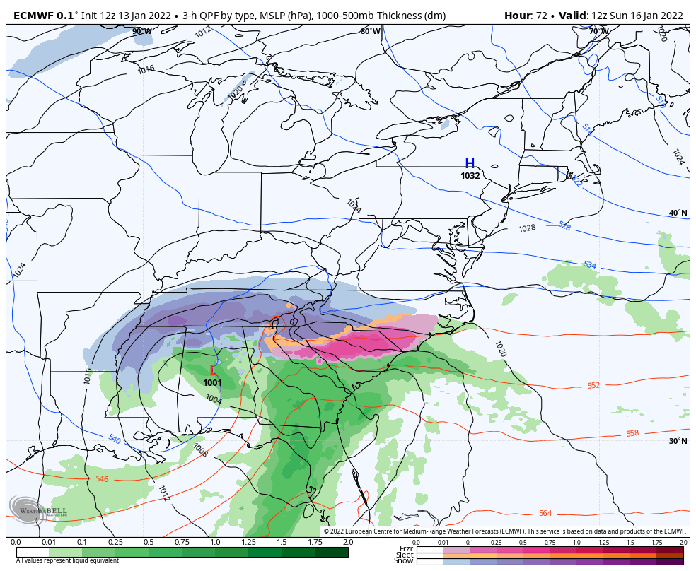
On the Grid:
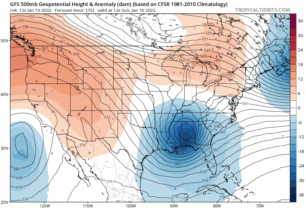
Band of snow will be spreading southward across Minnesota and Iow. We may see the Low Pressure central showing up.
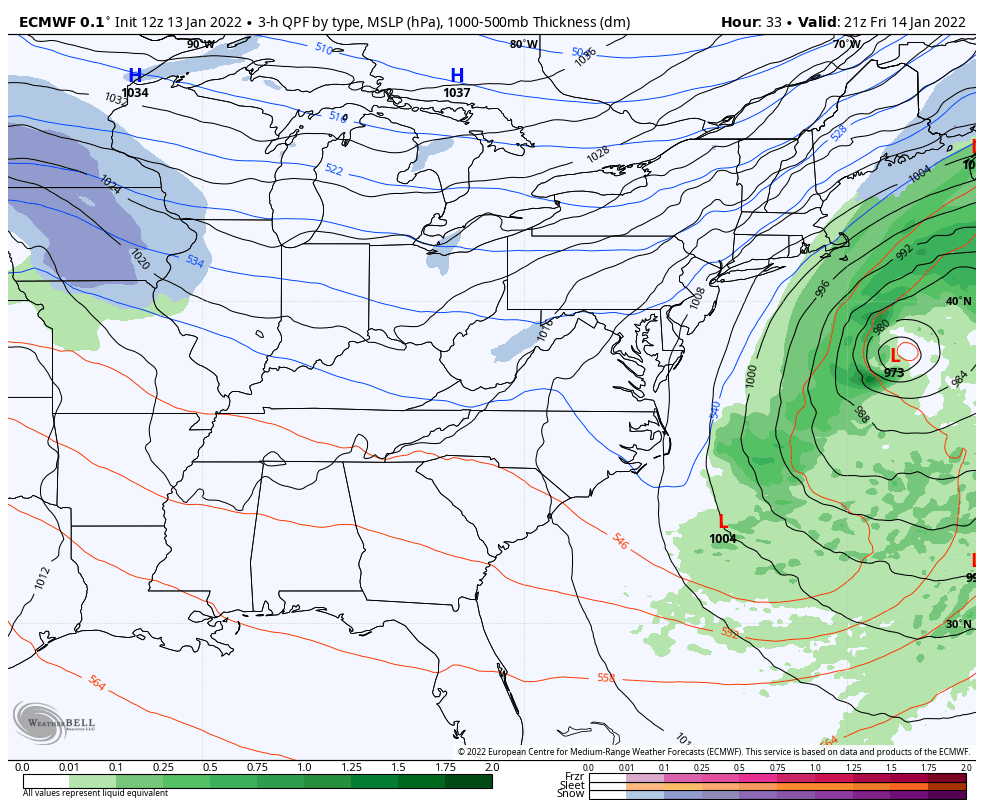
Computer guidance should initialize better and fine tune the rest of the track and timing.
The track of this snow heaven southward is on the back side of the jet stream trough…
Turning the Corner
This is when the Low Pressure rounds the base of the trough and moves to the east.
Where this is located will help determine how much moisture it picks up. That will also be make or break for snow and ice tracking into the Southeast.
We can compare the location of this phase to models for which is most accurate and trustworthy going forward.
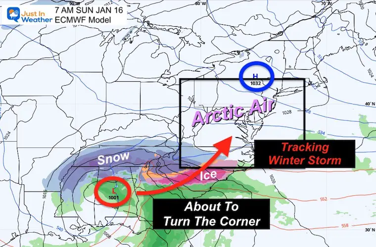
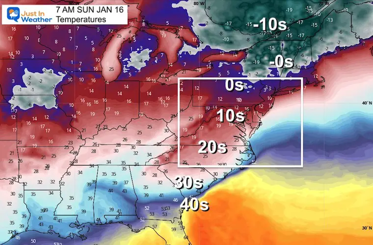
Arctic air will in place deep into the Southeast US.
Temps for our region in the teens or single digits.
Moving up the Coast
This is when the storm turns the corner up the east coast.
That is when the path of the Low should be more obvious.
This is what will determine precise track of the Low Pressure, which in turn will set up who gets all snow, ice, or change to rain.
Arrows indicate the wind direction with the cold air and snow zone.
This refines the track but still can have a buffer of 50 to 100 miles west or east that can make or break a snow forecast.
This time period there is time some uncertainty with how the Low behaves.
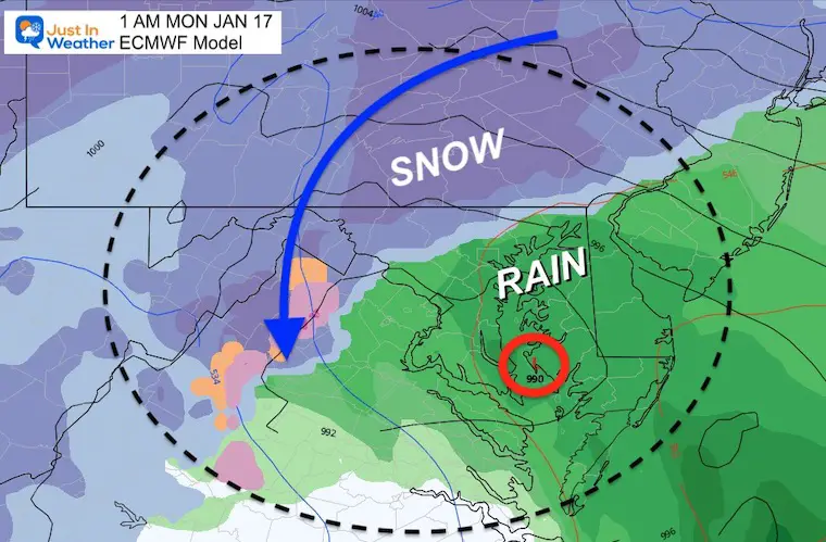
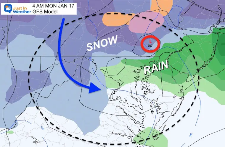
1 AM – Low in the southern Chesapeake Bay…
Warmer air wraps into the center, so the snow shield will be farther north and west.
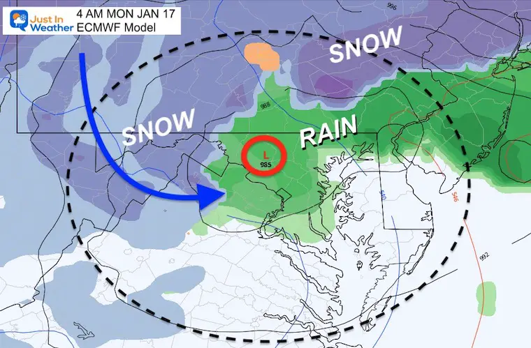
4 AM- This plots the Low pulling Northwest briefly. This is subject to change, and that could truly change the snow total or icing for much of metro areas if this tracks north northeast instead.
Notice the snow line ‘near’ Hagerstown and Harrisburg.
This is in the B Zone in my Expectations Map below.
This is a little faster and 50 miles farther east with the Low.
Here the snow is sill into Frederick, Westminster, and York/Lancaster. This plot suggests it then stays in the comma head and cold wrap around.
This is in the B Zone in my Expectations Map below.
That subtle track adjustment still could result in a big difference in the location in the snow and ice longer.
If you missed it earlier. More details will come into form on Friday.
*See the Jet Stream Outlook Below.
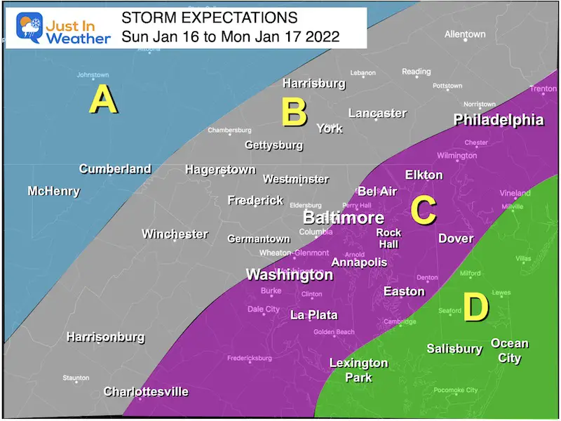
Most likely all snow. Totals where that happens can easily be over 10 inches.
Colder with more snow and sleet for longer.
Moderate totals until change over. Impact Sunday evening and night.
Still potential to mix to rain overnight.
Transition region! Slight change in track will determine a lot more or less snow.
Starts as snow Sunday afternoon to evening. Faster Change over to rain, perhaps by midnight.
Rain Monday morning, may end with some snow showers.
Most likely all rain and strong winds.
Want more winter? Check this out..
Welcome to the Winter Pattern that is NOT LIKE La Niña I wrote about in my seasonal outlook.
Isn’t it fun?
Faith in the Flakes.
Sign up and be the first to know!


Last Winter Recap: My Old Outlook And Your Grades Of My Storm Forecasts


