Thursday January 13 2022
The winter storm arriving Sunday will be strong and impactful for much of our region. There are a few things at this point that I am confident will occur. The storm will begin as snow for most, then it gets complicated.
My goal in this post is to simplify my messaging about this event. I hope this helps with ingesting all the info from all of your sources.
I will post updates on models and trends along the way.
Storm Notes:
High Confidence
- There will be a strong storm affecting us Sunday into Monday.
- It is going to start as snow for most of our region. The rain will be closer to the coast.
- Caution for travel late Sunday afternoon and evening!
- This storm has not formed yet.
- It will dive from Dakotas to the southern US then turn up the eastern US.
- As it turns north it will be intensifying rapidly.
- Monday is a holiday, so schools will definitely be closed!
Low Confidence Because…
- Where it forms will help to refine the timing and track.
- Where it ‘turns the corner, will firm up where the all snow, change over, and rain track will be.
- A shift 50 to 100 miles where this tracks by us can make snow totals double or cut in half. This is why I have not given snow totals yet.
- If you saw any snow maps elsewhere yesterday, they were cut in half or a 1/3 this morning. Models will likely change again.
Storm Expectations
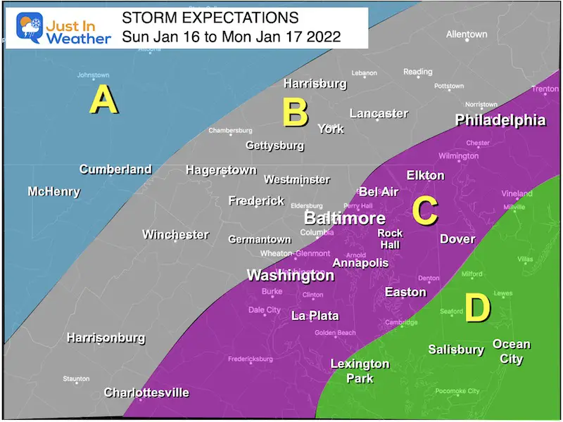
Regions
A:
Most likely all snow. Totals where that happens can easily be over 10 inches.
B:
Colder with more snow and sleet for longer.
Moderate totals until change over. Impact Sunday evening and night.
Still potential to mix to rain overnight.
Transition region! Slight change in track will determine a lot more or less snow.
C:
Starts as snow Sunday afternoon to evening. Faster Change over to rain, perhaps by midnight.
Rain Monday morning, may end with some snow showers.
D:
Most likely all rain and strong winds.
Repeat of Set Up
Looking Ahead: Winter Storm
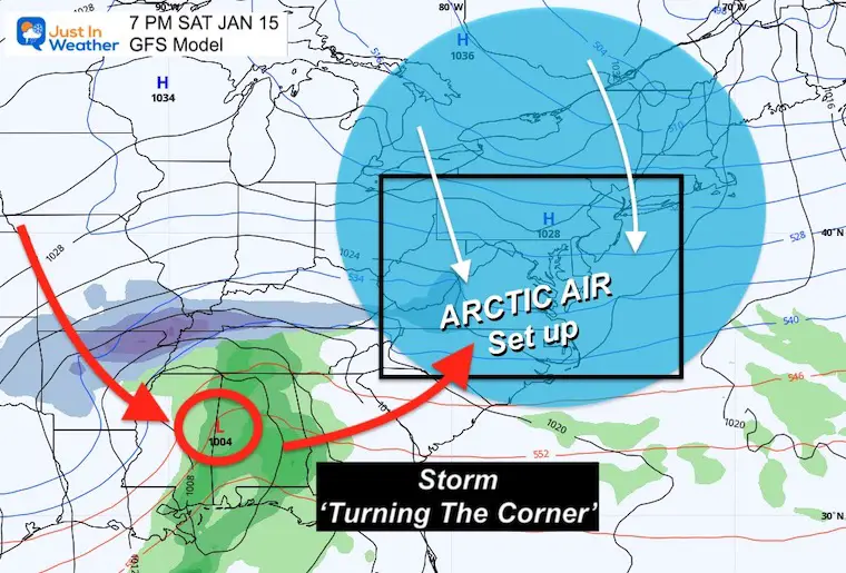
Saturday Set Up
Arctic air will spread down the eastern seaboard. This is the kind of air mass that will keep afternoon highs in the 20s for much of central Maryland.
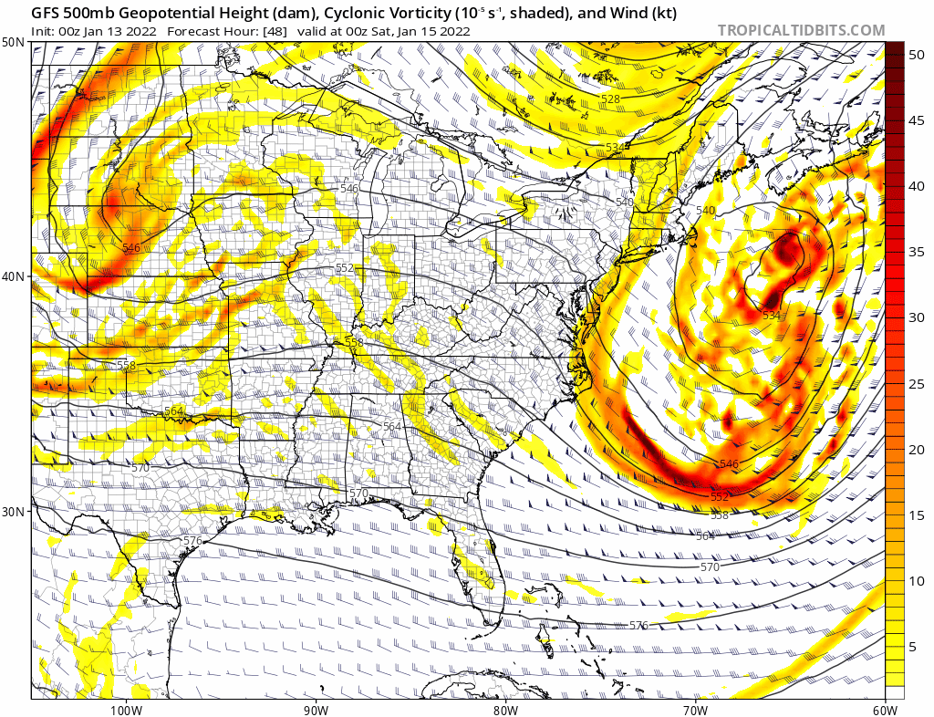
Jet Stream: 500mb Vorticity
Saturday afternoon to Monday morning.
I like this display to show the rapid spin up in the upper levels (18,000 Ft).
Watch the storm drop south from North Dakota to The Gulf Coast States, the ‘turn the corner’ up the east coast.
That is part of a deeply amplified trough. That ‘turn’ is what will help increase the spin up and rapid development of the surface storm.
Saturday Surface Weather
This storm has not formed yet. So the location of where this is on Saturday will help determine the rest of the trip.
A change of 50 to 100 miles for this on Saturday, can make or break a difference of 1 inch of rain or 10+ inches of snow on Sunday.
Yes, there will be the much snow in areas that remain all snow in this event.
GFS Model Animation:
This is just one solution and I am only showing it to help display the overall development. Please DO NOT expect this to remain the same with each update. Starting this afternoon I will being to get more detailed with the trends.
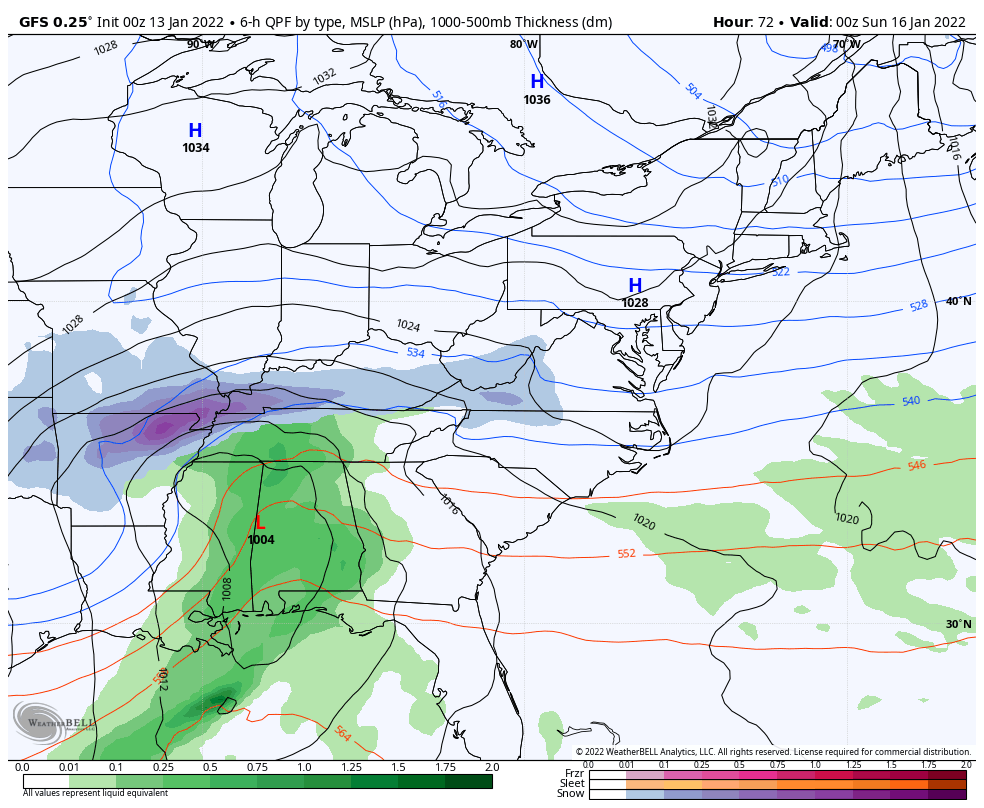
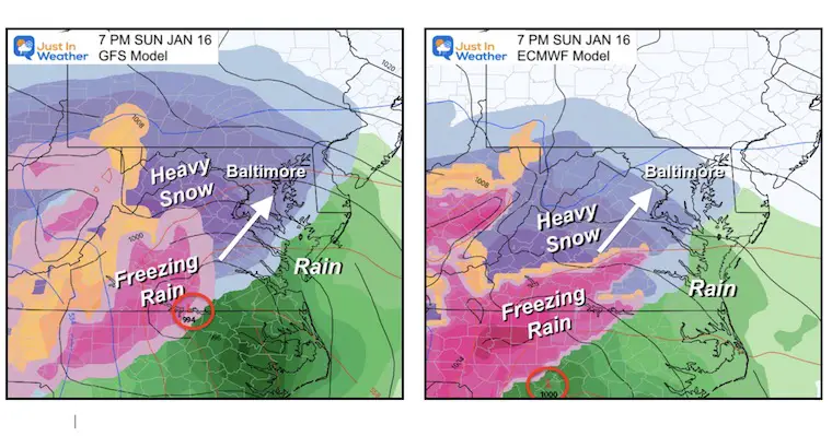
Model Comparison
Then good thing is that the GFS and European Models are in more agreement. Yes, there are other models that may show more snow at this time, but I see that as confirmation bias at this time. That is not my goal despite how much I love snow.
I did not do updates most of yesterday. If I had, there could have been a display of a lot of snow. The overnight models actually have cut the snow potential for Baltimore in half! I do expect there will be more fluctuation, which I why I am not showing snow totals yet.
Sunday Night
High Confidence: Most of our region will start with snow. Timing will be Sunday afternoon to evening for first flakes. Eastern Shore/beaches may be rain.
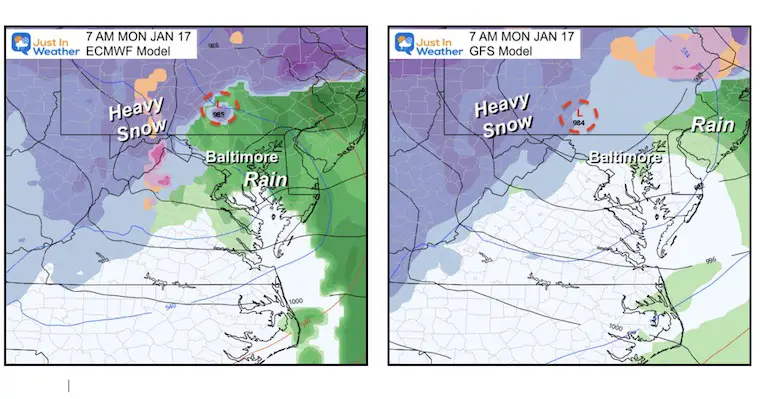
Monday Morning
Both main models bring Low Pressure through Baltimore and York/Harrisburg. This inland track would turn most areas to rain east of I-81. Even the GFS that shows snow here at the end, is posting rain overnight.
Heavy snow remains west and north.
*A simple shift east of 50 to 100 miles in track would double snow total potential.
*I still expect this to change and will highlight in each update.
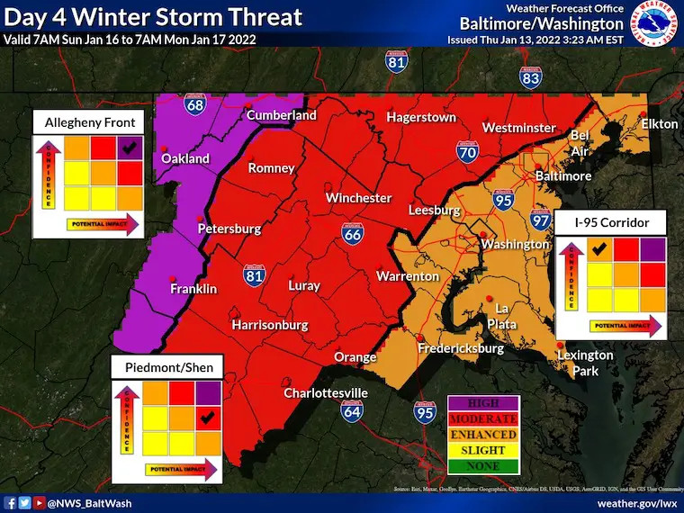
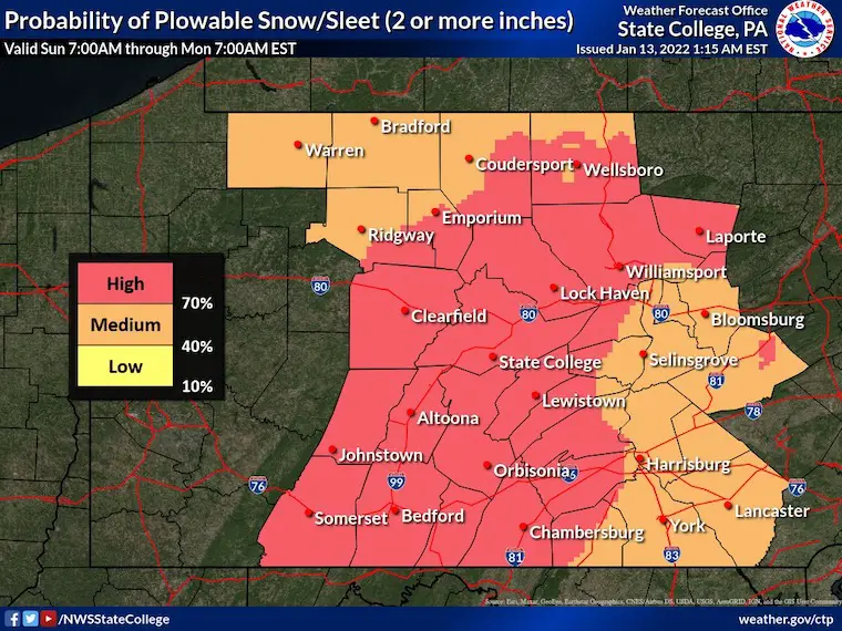
National Weather Service Storm Expectations
Sunday Evening To Monday Morning
This is actual a great display just focusing on the overall impact. Here is a look from the NWS Office for Baltimore/Washington and State College/Central PA
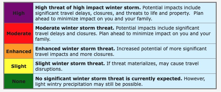
Legend
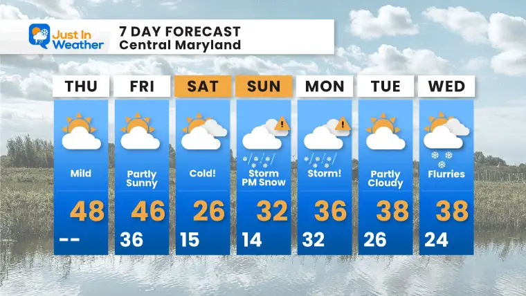
7 Day Forecast
ALSO SEE
ALL FITF GEAR

FITF THUNDERSNOW


Winter Outlook Series:
My Call For Snowfall

Last Winter Recap: My Old Outlook And Your Grades Of My Storm Forecasts


Please share your thoughts, best weather pics/video, or just keep in touch via social media


