Conditions: Baltimore, Maryland, 05/08/2024 12:10:03 am
Temperature

67°

Partly Cloudy

64°

Dew Point
Relative Humidity

90%

Feels Like

67°

Wind (N)

0mph

Air Pressure

29.72

Sun
Sun Rise

05:59 AM

Sun Set

08:06 PM

Day Length

14:07 Hours

Difference

2 min 0 sec gain

Moon
Moon Rise

06:01 AM

Moon Set

09:15 PM

Next: New Moon

May 07,2024

Moon Phase

New Moon

Climate
Average Low

49°

72°

Average High
Record Low

33°


(1997)

93°


(1930)
Record High
Conditions

My First Call For Snowfall Thursday Evening Friday Morning

Maryland Weather
Winter Weather
Forecast
Warnings

Wednesday Evening Update

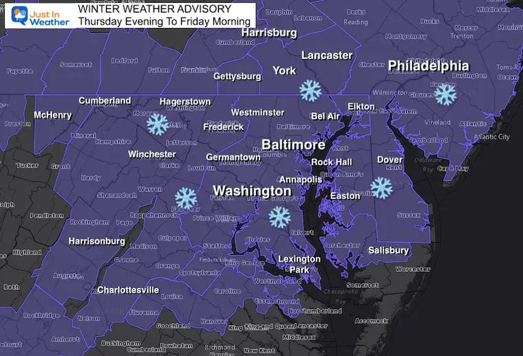
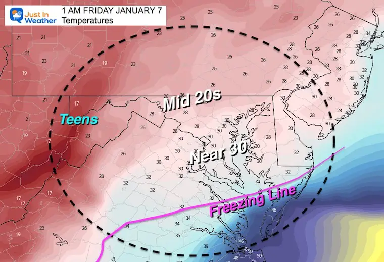
The Winter Weather Advisory has been expanded to include more of southern Pennsylvania. What that means locally is that there is more of a buffer for this snow event to fill in for areas that missed out on Monday. This includes north central Maryland and southern Pennsylvania. But once again the top spot may be south in ‘some’ of the same areas hit hard in Monday’s snow storm.

The timing supports delays for schools. It may arrive sooner, then end sooner as well. Most of this will fall overnight, and end by sunrise.

In this post I have my first call for snowfall. I did mention earlier that I expect this to be a general 2 to 4 inch snowfall.  My map below shows my LOW END CONFIDENT ZONE.

Winter Weather Advisory – Updated Map


Expectations:

  • This will arrive AFTER 6 PM Thursday in western areas.
  • Heaviest around midnight in metro areas.
  • Ending for most by sunrise Friday. 
  • Enough snow to shovel or plow
  • Not  as intense as the last event. 
  • Northern areas get in on this.


Set Up: Wednesday Evening 

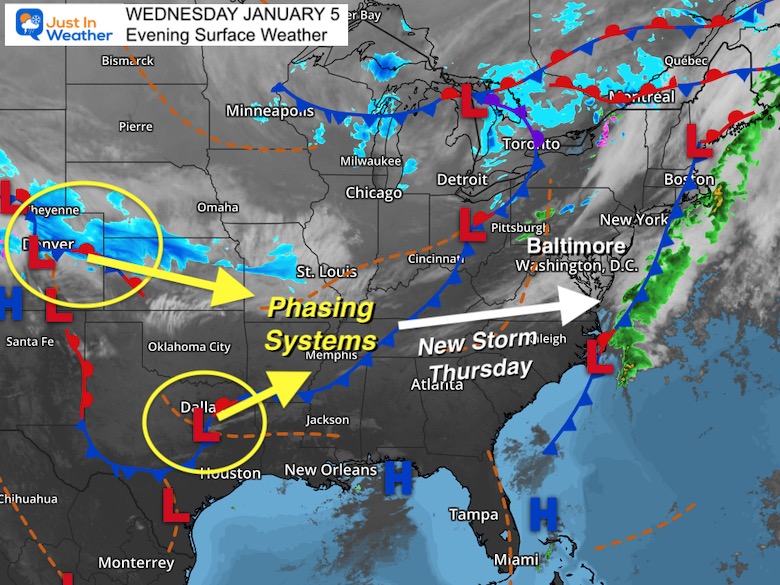
A little phasing expected between the system North of Denver and southern branch energy seen near Dallas/Oklahoma City.

The new storm will take form Thursday. I expanded on the development in this afternoon report.


Radar Simulation —> slider

Updated NAM 3 Km

january-5-weather-snow-radar-nam-thursday-pm-5
january-5-weather-snow-radar-nam-thursday-pm-6
january-5-weather-snow-radar-nam-thursday-pm-7
january-5-weather-snow-radar-nam-thursday-pm-8
january-5-weather-snow-radar-nam-thursday-pm-9
january-5-weather-snow-radar-nam-thursday-pm-10
january-5-weather-snow-radar-nam-thursday-pm-11
january-5-weather-snow-radar-nam-friday-am-12
january-5-weather-snow-radar-nam-friday-am-1
january-5-weather-snow-radar-nam-friday-am-2
january-5-weather-snow-radar-nam-friday-am-3
january-5-weather-snow-radar-nam-friday-am-4
january-5-weather-snow-radar-nam-friday-am-5
january-5-weather-snow-radar-nam-friday-am-6
january-5-weather-snow-radar-nam-friday-am-7
previous arrow
next arrow


My First Call For Snowfall 

Reminder: This is my most confident number at this time.

I like to begin on the low end, with upside potential.

If there is more support for higher totals, I will include that in my Final Call.

*It is better to start lower and build up if needed.


UPDATE THURSDAY MORNING

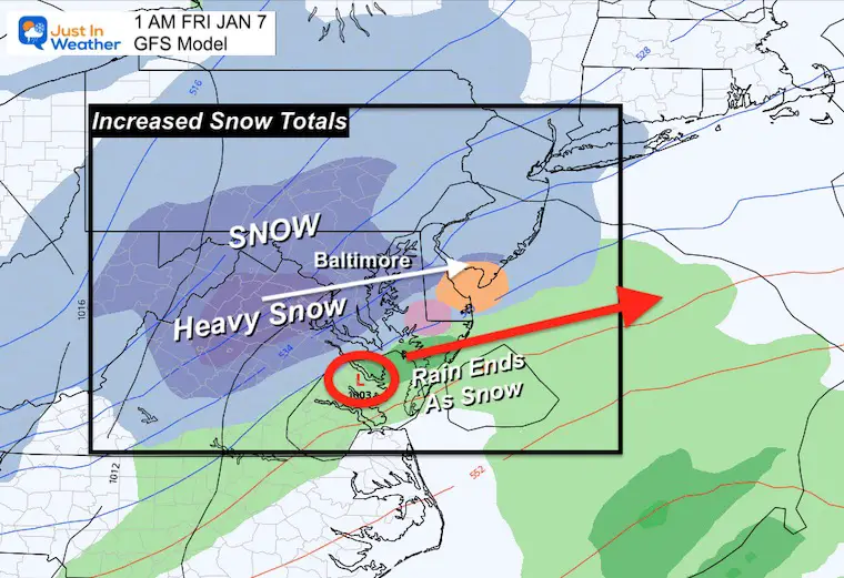
Click to see: New Data = I INCREASED My Call For Snowfall


Thoughts:

Most of our region can expect the upper end to the 1″ to 3″.

The + is for upside potential.

The top zones for up to 4 inches or higher will be in the mountains of western Maryland and west of I-81. Also in the top zone from Monday around Washington to Annapolis and Easton.


Snapshot at 1 AM Friday

Temperatures

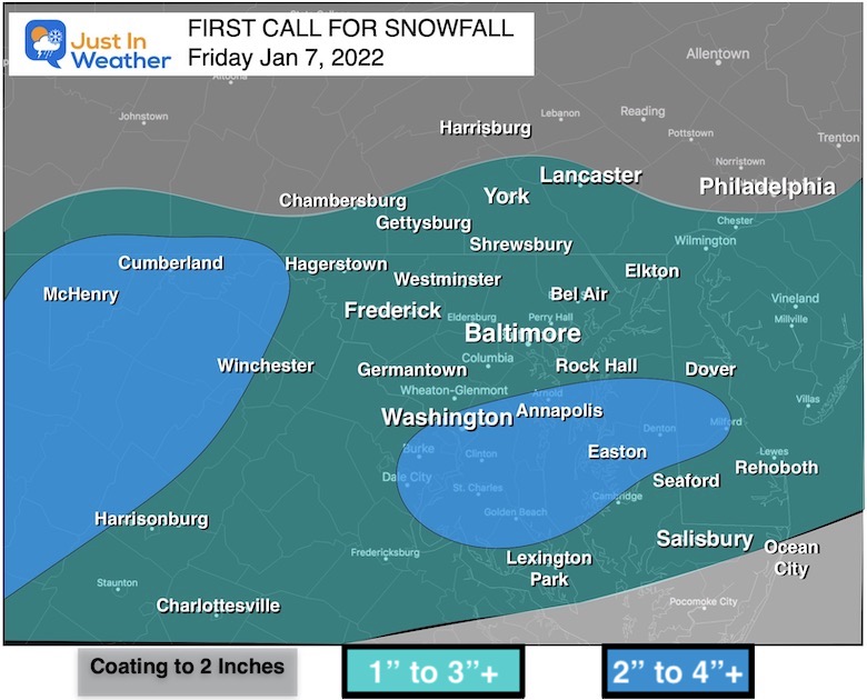
It will be cold enough for stickage. The ground is suffering to support it as well as the air, so more of what falls can be considered to the total results.


My Notes:

  • This looks like a general 2 to 4 inch event, but at this time it’s conservative to expect 1 to 3 inches for most with higher expectations.
  • The NAM is tracking NORTH… Which will include more that missed out last time, but also brings warmer air to the southern zones.


Weather posts straight to your inbox

Sign up and be the first to know!


ALSO SEE


What is Faith in the Flakes: History of December 5th Snow


ALL FITF GEAR


Winter Outlook Series:

My Call For Snowfall


Last Winter Recap: My Old Outlook And Your Grades Of My Storm Forecasts

Winter Weather Page – Lots of resources


Solar Cycle Increasing Sunspots Suggests More Snow


Comparing 4 Different Farmer’s Almanacs: Majority colder winter outlook than NOAA


NOAA Winter Outlook- But Read The Fine Print


Signals For Early Start To Winter In November


Winter Outlook Series: La Nina Double Dip


Nor’easters May Give Hint For Winter La Nina Pattern


Winter Folklore Checklist


Please share your thoughts, best weather pics/video, or just keep in touch via social media

Facebook: Justin Berk, Meteorologist

Twitter: @JustinWeather

Instagram: justinweather