How many people asked for snow for Christmas? I mean, there was no chance for us this year, but that doesn’t rule out the rest of winter. Heck, it does not even rule out next week.
Perhaps enough wished have piled up to give us the boost for a little something-something on Monday.For the record, this is simply a weather update, not a full forecast. What I want to show you perked me up out of my Covid slumber, so bear with me. I’ll get to that in a moment.
Christmas 2021 – Warm But Not A Record:
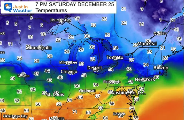
BWI officially hit 68ºF at 2:29 PM
Record was 72ºF in 1964
‘Normal’ should be 45ºF
The last ‘warm’ Christmas was in 2015. I double checked the records and we did hit 71ºF.Reminder that we got our 29.2” snowfall one month later.
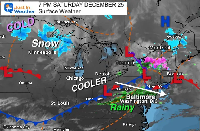
Christmas Night Weather
The warm air is coming to an end for us with a cold front. This has sparked a solid line of rain, which is a gift itself for our growing drought risk.
The rain will be ending overnight, and leave us with clearing and cooler weather Sunday.
Temperatures at 7 PM
The numbers on this evening’s map show arctic air, but it is really far away in the Northern Plains. That’s where temps have dropped to the single digits and teens.
The freezing line is still across the Great Lakes.
The core of the cold will stay to our north, but just a small sliver will play a role in our weather by Monday morning.
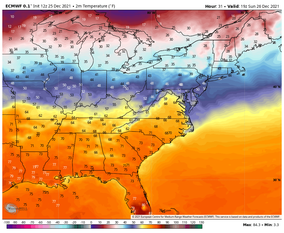
Temperature Forecast
3 PM Sunday to 3 PM Tuesday
Here is the European Model animation showing the trend of temps in ºF. While we get back to the 50s Sunday afternoon, some of that arctic air will try to ooze south by Monday morning. Just enough may settle in ahead of the next weather systems to produce a wintry mix.
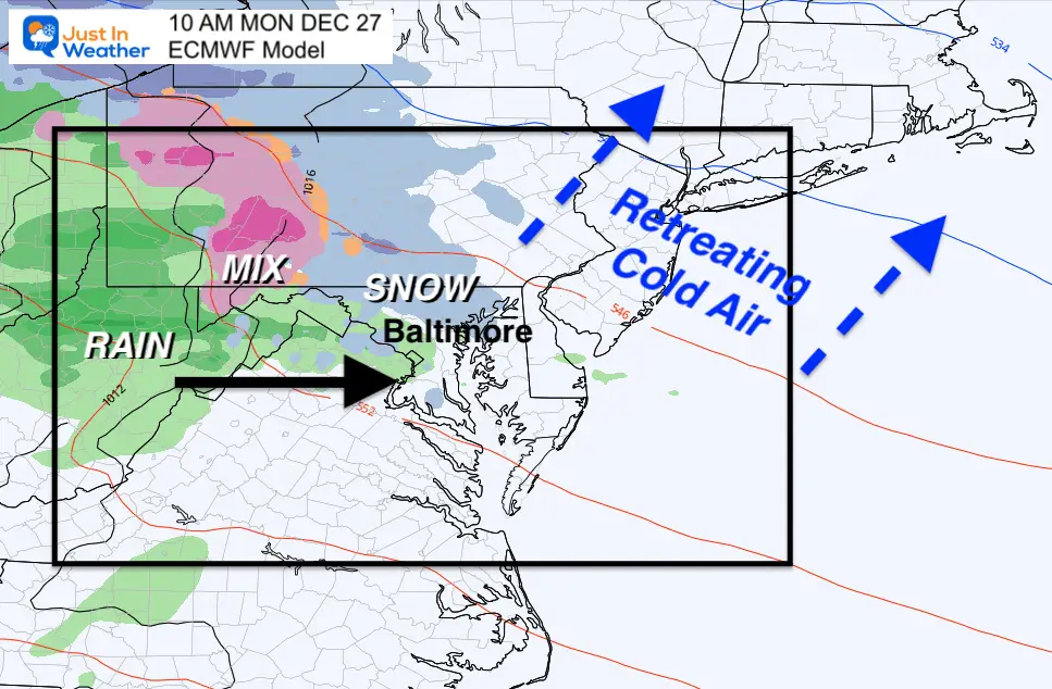
Snapshot Monday at 10 AM
The European Model has been trending to support the onset of snow.
We miss out on the really cold air, but just enough left over at mid and high levels to allow the clouds to produce snow and or a wintry mix.
It’s important to note that our surface temperatures will be borderline at best in the northern zones. So I do not see a travel issue locally. But traveling in PA and metro NY could be worth paying attention to….
GFS Model Timeline —> slider
Here we see the defamed American Model. While it is hanging its head in shame from prior forecast fails, it is also picking up on this wintry event. However this is in a more robust manner.
Here we see colder air expanding farther into Maryland. The suggestion is more of a snow and icy mix through the day.
december-25-weather-snow-ice-rain-monday-am-10
december-25-weather-snow-ice-rain-monday-pm-1
december-25-weather-snow-ice-rain-monday-pm-4
december-25-weather-snow-ice-rain-monday-pm-7
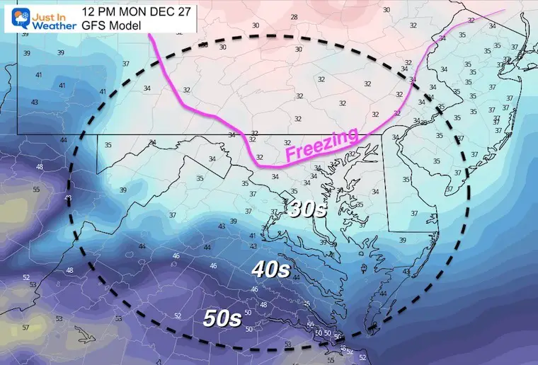
GFS Temperatures
Noon
This model is showing a deeper layer of cold air, still all the way to the surface of north central Maryland.
This is the reason for more snow and ice than the Euro, but I am not sure I can buy it yet.
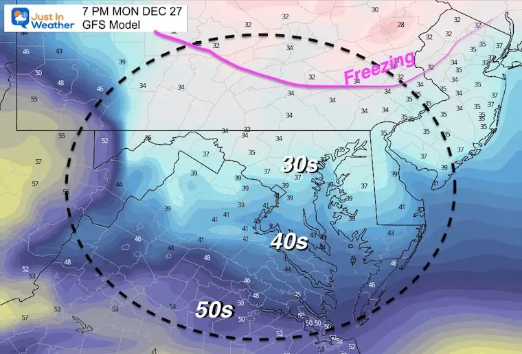
7 PM
While the freezing line retreats, as often is the case with cold air damming, we see the cold air hanging in place longer… making for a raw type of day and evening in the region.
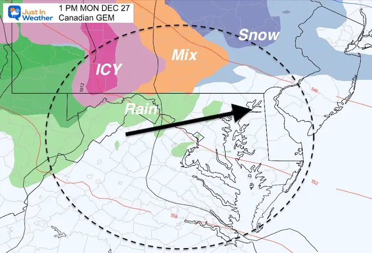
Canadian Model Comparison
This solution shows a potent winter weather system, but mainly north into Pennsylvania.
Notes:
It’s time to pay attention and reevaluate on Sunday.
I doubt local impact on roads, but this may apply if you are traveling north on Monday morning.
Yes, we just had a warm day and the computer guidance has been poor lately. But this does fit in the suggestion that I had made: We could get events that only show up 2 to 3 days prior and may seem like a surprise.
I did notice this yesterday, and decided to wait and see if there has been consider a trend. We have it now, which is a benchmark for tomorrow.