My Thoughts On Saturday Snow Crashing Temps And High Winds
March 10 2022
Thursday Evening Update
The closer we get, the more it looks the same. This may possibly be winter’s last gasp, and it is trying to go out with a bang on Saturday. How big of a bang may be up to your interpretation.
Temps will fall. Rain will turn to snow, and it may be heavy at times. Winds will gust to 40 mph and wind chills will hurt. Then regardless of how much snow may lay, stay, and pile up (our not)… a hard freeze turn anything that is wet to ice Saturday evening into Sunday morning.
Set Up: Jet Stream
The Polar Vortex Disruption that got some doubters worked up is going to prove itself. The trough digging into the Eastern US on Saturday will unleash true arctic air and help develop a strong coastal storm.
The core of the cold will be to our north, but the strength of the storm will pull down our coldest air into Sunday. (Next will we will bounce back up quickly).

Most Aggressive Scenario:
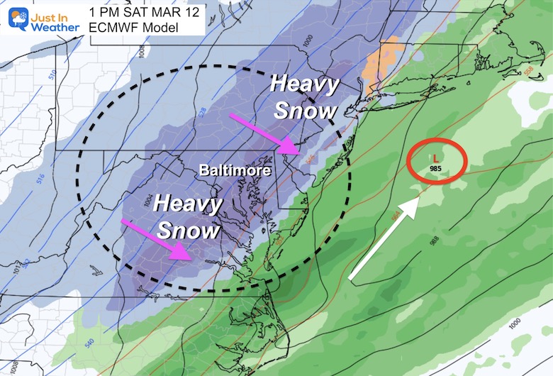
The European Model has been consistently showing the faster change to heavy snow for metro Baltimore and even down the Bay to Southern Maryland.
Below is a comparison to the GFS Model that has less snow but still impressive with the winter elements.
Headlines
- Saturday will bring snow!
- We all should see it, and it may be heavy in metro and Bay areas as well.
- Temperatures will be falling below freezing during the afternoon.
- How much may fall and actually stick then pile up is a challenge to call now.
- Winds will gust 30 to 40 mph with the cold air.
- Wind Chills will be in the TEENS Saturday Afternoon.
- Icing a legitimate possibility Saturday Evening into Sunday Morning.
Wild Weekend Weather
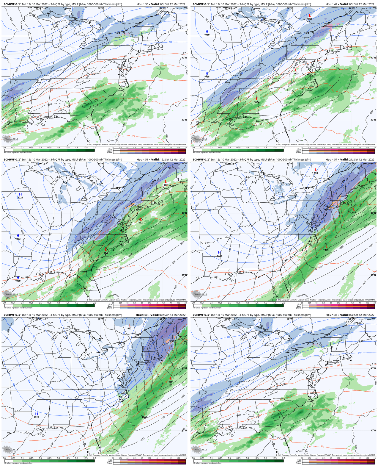
I continue to show the more impressive European Model scenario. We can see the Polar Front Phasing and showing us a new coastal Low helping to work off the cold and bring rain to snow line to the coast.
This will be both a snow maker and a Wind Machine.
Animation: 7 PM Friday to 7 PM Saturday
Closer Look At Saturday
Begins as rain, then turns to snow. I am only focusing on the transition to snow for now. There is a split in the intensity expectation (European is heavy while the GFS is lighter). But the timing during the daylight will definitely be challenging to overcome the melting and maximize the stickage. If this was January, it would be a much different story.
The European Model
- This continues to be the more aggressive solution, with the upper level energy lining up just as the cold air passes through Baltimore.
- Here we see the the snow line passing through central Maryland by 10 AM.
- Then moderate to heavy snow around Bay areas and on to Delmarva early in the afternoon…. Reaching the beaches before 3 PM.
- This seems far fetched! However, this is a very reliable computer model AND has been consistent with this set up for the past few days.
4 AM to 7 PM Saturday —> slider
GFS Model
This shows more rain earlier and less now. The reason is because of a track faster and closer (more west). This will delay the transition of snow in our region until after the bulk of the energy passes by. However, it still produces accumulating snow for Western Maryland.
Metro areas: Transition to snow between 10 AM and noon.
Snow showers for southern Maryland and Delmarva later in the afternoon and evening. This solution brings lighter precipitation, but what is important is that if and when this happens, it allows the much colder (freezing) air to catch up. See below
4 AM to 7 PM Saturday —> slider
Wind Forecast
I mentioned this will be a wind machine, and that will be most of the day. But the most aggressive part may be during the transition to snow. Here is a look at 1 PM, with the Northwest wind behind the Low Pressure STEADY over 20 mph, and GUSTING TO 40 mph.

TEMPERATURES
I decided to show the warmer GFS Model… Here you will still see a dramatic drop to and below freezing.
At the 4 PM Time Frame- I added the Wind Chill forecast for true shock value.
Key Timeframes —> slider
7 AM, 12 PM, 4 PM (Temps and Wind Chill), and 7 PM
SUNDAY MORNING
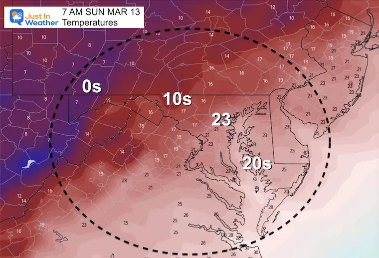
Winter’s return will not be questioned at this time. I have no intention to dramatize this, rather simply acknowledge the questions I keep getting: Sunday Morning is when a lot of people go to Church or have some other plans. There will be potential for ICE wherever anything was wet late Saturday. Despite the strong winds, there will be precipitation adding to wet ground after temps crash…
Please consider this. I advised all of my clients that this should be a salting event for their properties.
Reminder: Clocks Go Forward 1 Hour, but still not much of a chance to sleep through this…
(Wind Chills will be in the teens and single digits for most of the region.)
So, HOW MUCH SNOW?
I am still holding off on this final bit of information to get a grip on the realistic time when snow may overtake the warmer ground. If the European Model is correct, that could happen quickly for metro Baltimore and west… Perhaps even for southern and Bay areas. If the GFS is correct, that subtle difference may mean less snow sticks, but still brings on the icing before Saturday evening.
For the record, my time is split with a prescheduled family activity (I can explain more later).
I am doing my best to carve out a few hours to work, but it is less than I normally would dedicate. Thank you for trusting my take on the weather. I hope to be able to make any needed maps and share with you as time allows.
Faith in the Flakes.
Extended Forecast
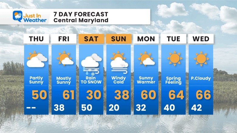
In case you missed my morning report, I mentioned the second polar vortex disruption does not appear to affect us. This strong event will be enough and then allow spring to surge back in next week. This may be it…
Weather posts straight to your inbox
Sign up and be the first to know!
ALSO SEE
What is Faith in the Flakes: History of December 5th Snow
ALL FITF GEAR
FITF THUNDERSNOW
Winter Outlook Series:
Last Winter Recap: My Old Outlook And Your Grades Of My Storm Forecasts
Winter Weather Page – Lots of resources
Solar Cycle Increasing Sunspots Suggests More Snow
Comparing 4 Different Farmer’s Almanacs: Majority colder winter outlook than NOAA
NOAA Winter Outlook- But Read The Fine Print
Signals For Early Start To Winter In November
Winter Outlook Series: La Nina Double Dip
Nor’easters May Give Hint For Winter La Nina Pattern
Winter Folklore Checklist
Please share your thoughts, best weather pics/video, or just keep in touch via social media
Facebook: Justin Berk, Meteorologist
Twitter: @JustinWeather
Instagram: justinweather
*Disclaimer due to frequent questions:
I am aware there are some spelling and grammar typos. I have made a few public statements over the years, but if you are new here you may have missed it:
I have dyslexia, and found out at my second year at Cornell. I didn’t stop me from getting my meteorology degree, and being first to get the AMS CBM in the Baltimore/Washington region.
I do miss my mistakes in my own proofreading. The autocorrect spell check on my computer sometimes does an injustice to make it worse.
All of the maps and information are accurate. The ‘wordy’ stuff can get sticky.
There is no editor that can check my work when I need it and have it ready to send out in a newsworthy timeline.
I accept this and perhaps proves what you read is really from me…
It’s part of my charm.
#FITF


