February 10 2024
This update presented Saturday evening is for the next weather event and an attempt for winter to show back up. There has been chatter about this event, and I even broke my own protocol earlier this week to mention it 8 days ahead of time simply to keep hope alive for snow lovers.
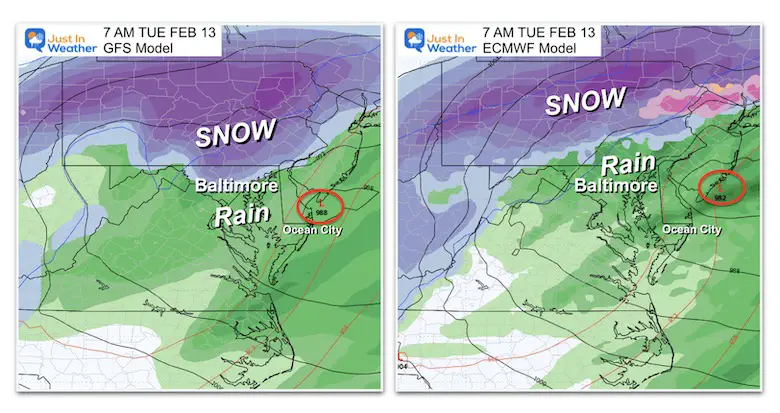
If you are new to my site, I am a self-aware snow lover. With that in mind, I keep my bias in check, AND I have NOT overindulged on this snow potential for two reasons: First, I do not see a supply of needed arctic air. The other is the inconsistency between the two main models. We began to see some agreement yesterday, but as of today, this is the comparison of the GFS and European Models.
Tuesday Morning Model ‘Suggestions’
The American GFS model has been consistently trying to bring snow near Baltimore. The European ECMWF has been consistently trying to pull the storm farther NORTH and taking the snow there as well.
With reference to Baltimore, this snow will be on the northern edge or well north. This will be a slushy and moderate snowfall for central Pennsylvania to possibly metro New York. Before looking a little closer, I want to help with the big question I keep getting:
Why are the models so different?
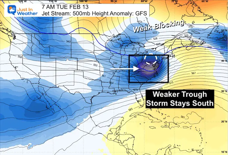
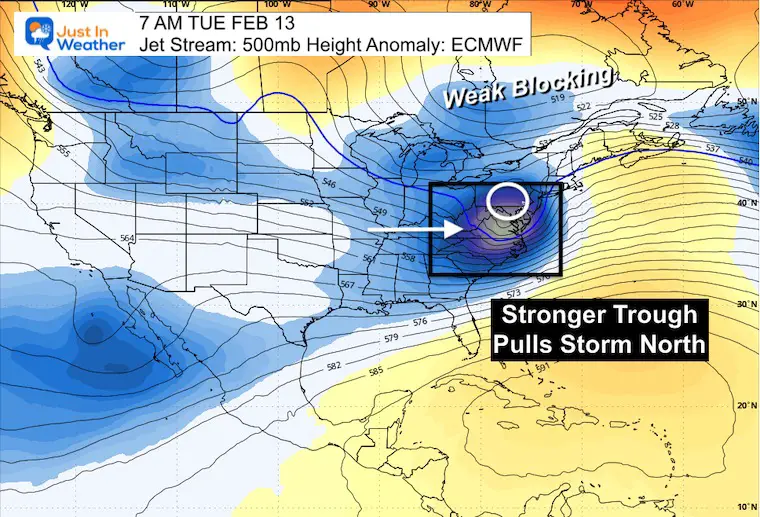
To answer this, we can just look at the jet stream. Here is the 500mb Level, roughly 18,000 Ft above the surface. I was focusing on the Blocking High in Eastern Canada or lack thereof… But the jet stream short wave with this storm seems to be the key.
The GFS Model actually has a weaker event aloft, allowing the Surface Low Pressure and snow to track farther south into parts of Maryland.
The ECMWF Model has a slightly stronger short wave, which pulls the surface Low Pressure farther north. This subtle feature can result in a shift up to 100 miles and a big result for a large population on the ground.
Back To The Surface Storm
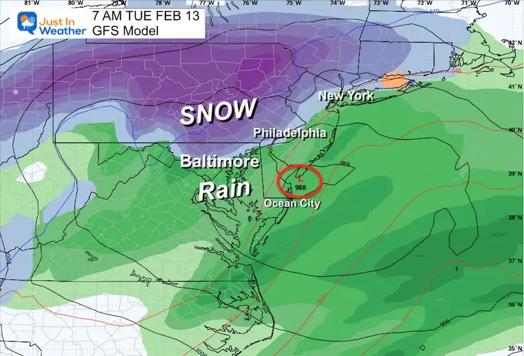
GFS Model Animation
1 PM Mon to 7 PM Tue
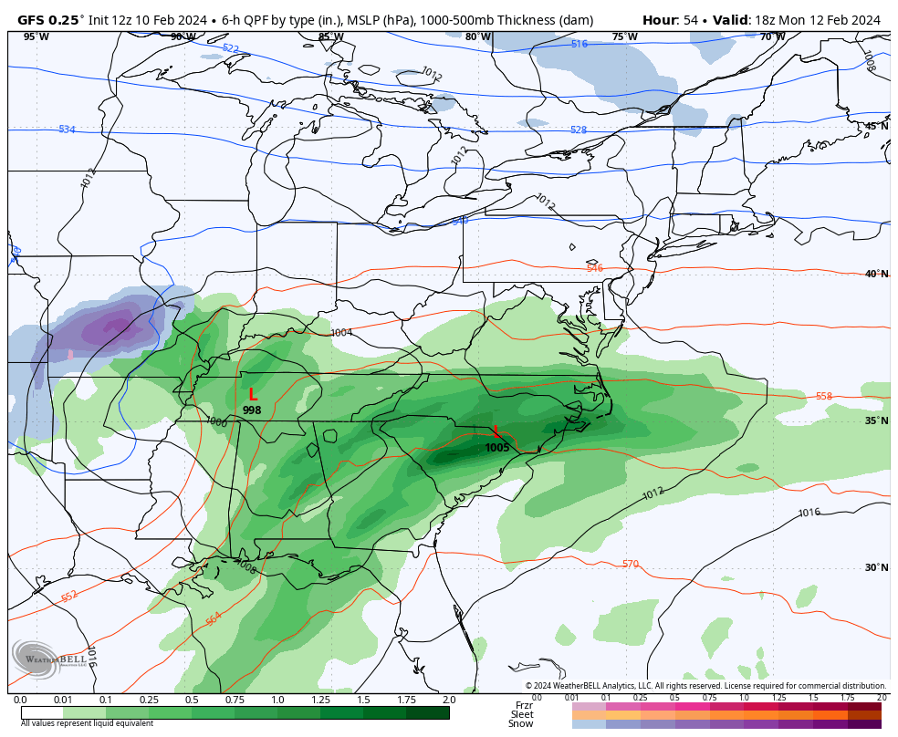
Snapshot 7 AM Tuesday
Low Pressure near Cape May, NJ.
‘IF’ we see snow in Maryland, it may be a slushy mix across the northern suburbs of Baltimore.
This is a classic setup, with the higher elevations farther inland having a better chance for snow and maybe a slushy stickage. This will approach the I-95 corridor between Philadelphia and New York.
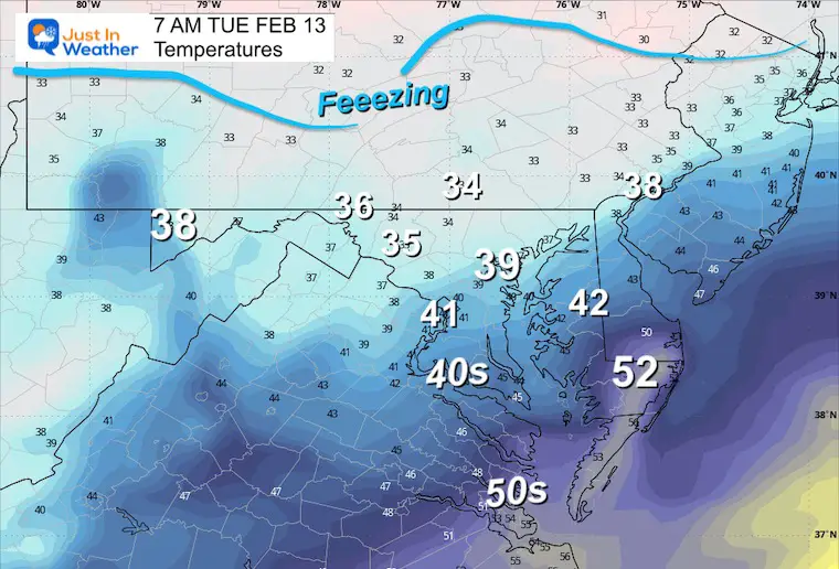
Temperatures
This is crucial! I DO NOT see a freeze in our region. It can snow with temps in the mid-30s, and if moderate snow falls at night, it can overtake the warmer ground for slushy stickage.
Because the freezing line appears to be isolated to far Western Maryland and Central PA, I hesitate to even mention the potential.
NOTE:
IF you see a snowfall potential map, RUN AWAY! Actually, just look with caution. The ground has been warmed by our 50s and 60s recently, plus there is a lack of arctic air. A lot of what may fall will melt or be compromised.
The WARMER Solution
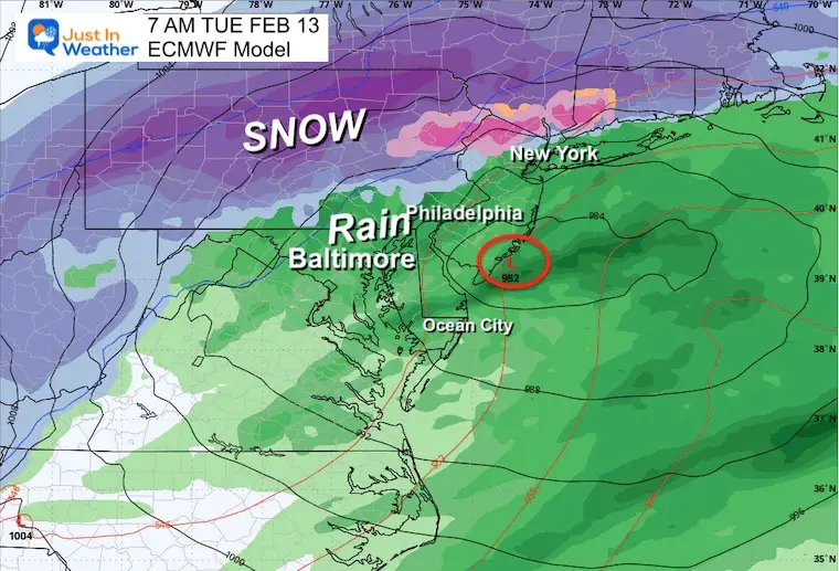
ECMWF Model Animation
1 PM Mon to 7 PM Tue
Snapshot 7 AM Tuesday
Low Pressure located near Atlantic City, NJ. This I not much farther north, but the upper air influence takes over the location for the cold air support.
This pushes the snow line up to I-81 in southern PA. That is north of York and closer to Harrisburg. Central PA is still in on the accumulation, but Philadelphia stays wet, and metro New York sees more of a rain to sloppy mix on their north side.
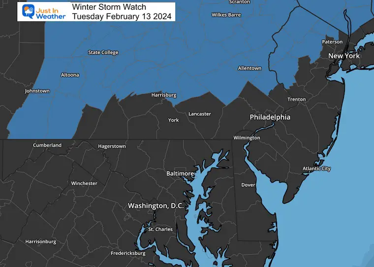
Winter Storm Watch
The National Weather Service has issued the latest alerts to begin late Monday night into Tuesday morning for this event.
The southern edge of the concern region is near Harrisburg, PA. It remains north of Philadelphia and New York.
This is matching up with the temperatures and European Surface plots.
It does not promise the final snow line… just the better odds now where there will be impact on travel. As we get closer, this region will be revised to a Warning or Winter Weather Advisory depending on the expected snow totals…. Some areas not in the Watch now may be added.
Stay tuned….
A slight shift in the storm track, intensity, timing, and how cold temps may fall will all play a role in what may lay and stay on the ground.
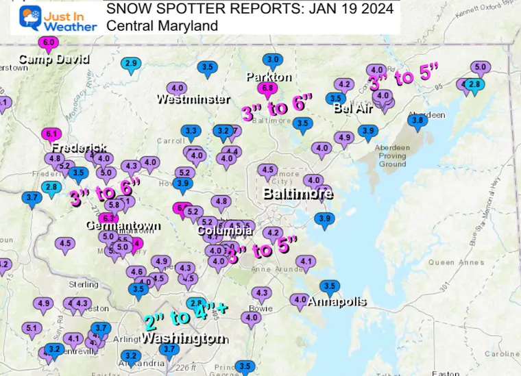
Recent Snow Reports
January 19 Recap
Click here for the maps and full report
Jan 16 Snow Report
Click here or the map to see: The Snow Report Ending Jan 16

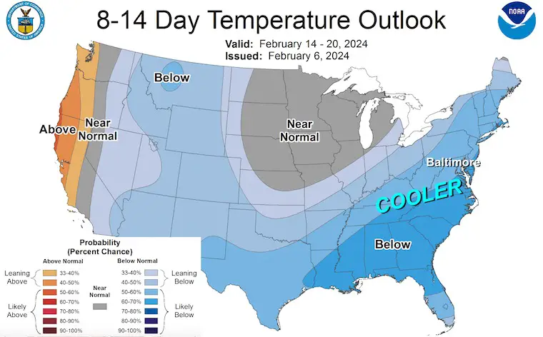
NOAA OUTLOOK COLDER
On Tuesday night, I wrote this report explaining the pattern change. Click this map or here for more…
Subscribe for eMail Alerts
Explore More
Maryland Snow Climate History And Other Winter Pages

STEM Assemblies/In School Fields Trips Are Back
Click to see more and ‘Book’ a visit to your school
RECENT Winter Outlook Reports:

Faith in the Flakes Gear

El Niño Winter Updates

Computer Models Support East Coast Storm Track

El Niño Advisory
The latest NOAA report is confident in a Very Strong event. Possibly HISTORIC! This refers to the temperatures in the Pacific, with impacts on the US Winter Storm Track.

Winter Weather Folklore: Top 20 and more signals from nature for snow.
NOAA’s Winter Outlook 2024
Winter Outlook 2024 From Two Farmers Almanacs Return to Cold and Snow
Please share your thoughts and best weather pics/videos, or just keep in touch via social media
RESTATING MY MESSAGE ABOUT DYSLEXIA
I am aware there are some spelling and grammar typos and occasional other glitches. I take responsibility for my mistakes and even the computer glitches I may miss. I have made a few public statements over the years, but if you are new here, you may have missed it: I have dyslexia and found out during my second year at Cornell University. It didn’t stop me from getting my meteorology degree and being the first to get the AMS CBM in the Baltimore/Washington region. One of my professors told me that I had made it that far without knowing and to not let it be a crutch going forward. That was Mark Wysocki, and he was absolutely correct! I do miss my mistakes in my own proofreading. The autocorrect spell check on my computer sometimes does an injustice to make it worse. I also can make mistakes in forecasting. No one is perfect at predicting the future. All of the maps and information are accurate. The ‘wordy’ stuff can get sticky. There has been no editor who can check my work when I need it and have it ready to send out in a newsworthy timeline. Barbara Werner is a member of the web team that helps me maintain this site. She has taken it upon herself to edit typos when she is available. That could be AFTER you read this. I accept this and perhaps proves what you read is really from me… It’s part of my charm. #FITF


