


May 9 Cooler With Rain And Severe Storm Risk Tonight South
Thursday May 9 Morning Report Today is the first day of the year with sunrise before 6 AM in Baltimore, but we won’t see it. After a high temperature of…
January 25 2024
Thursday Morning Update
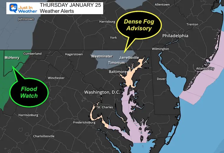
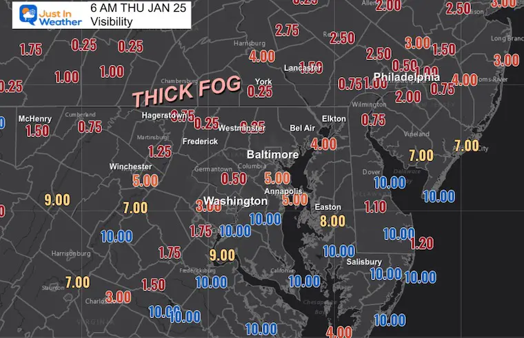
The fog and drizzle that developed yesterday have been expanding overnight. The fog is thickest north of Baltimore in the hills, where an Advisory has been issued. I would still plan for poor visibility on your travels this morning.
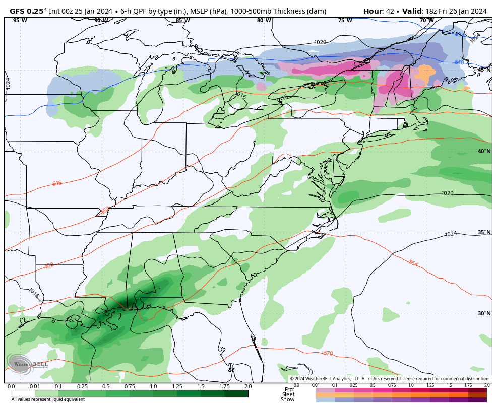
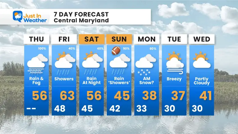
Periods of rain may be heavy at times, but there will also be a break or two today. This will taper off tonight, but we can’t rule out more showers on Friday.
A Dense Fog Advisory is in effect for Carroll, Northern Baltimore, and Harford Counties in Maryland. There are more areas of fog outside of these zones to expect in your travels. The heavier rain and snow melt has promoted a Flood Watch in Garrett County, Maryland.
Use the controls to zoom in closer.
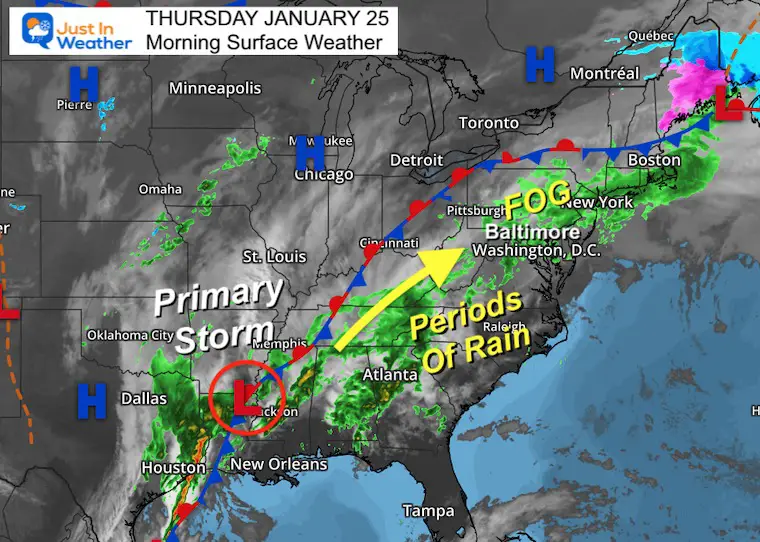
The next event is centered on the Low Pressure forming in Texas. There will be heavier rain there, but a flow in the atmosphere will send impulses to carry that rain our way tonight into Friday morning.
With warmer and moist air flowing over our snowpack and cold water (Bay), there will be fog forming during the day and evening. This may be thick especially as rain becomes more steady by Thursday morning.
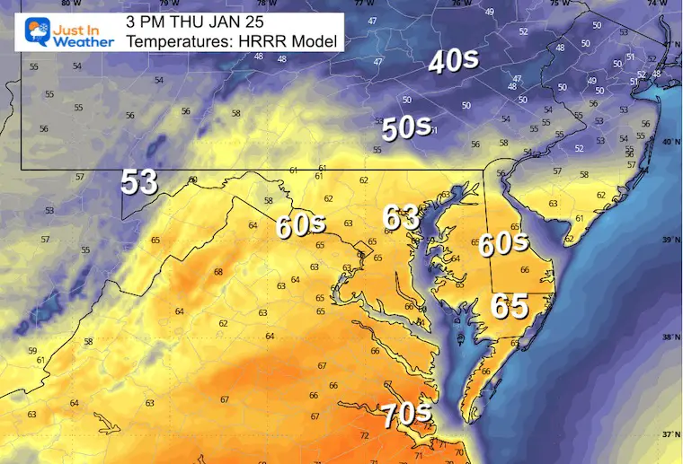
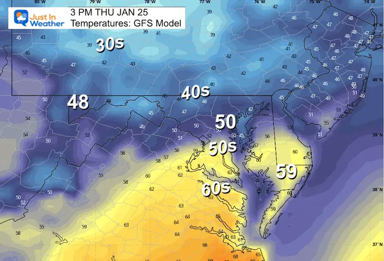
Here is an example of how difficult it is to pin down the push of warm air and the influence of both the colder water AND snowpack.
Compare these models for how different they expect this afternoon to be:
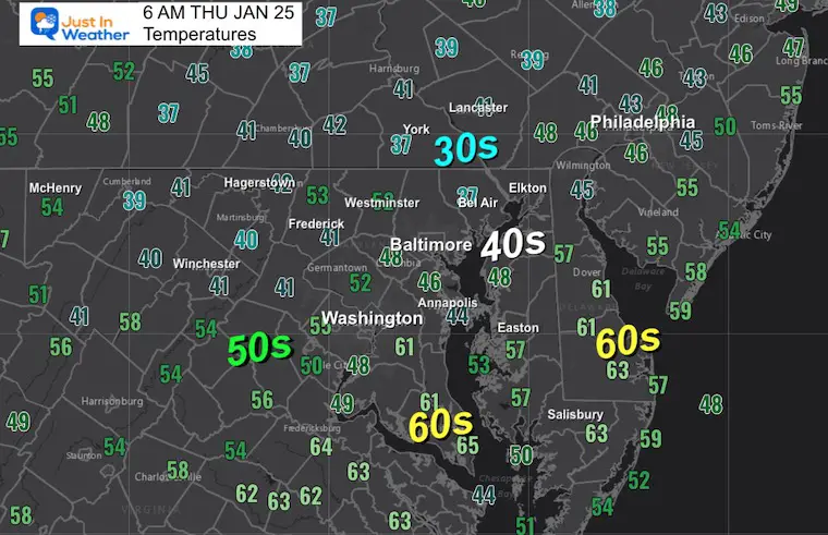
Baltimore, for example is 63ºF on the HRRR but 50ºF on the GFS.
HRRR Model
TODAY January 25
Sunrise at 7:19 AM
Sunset at 5:19 PM
Normal Low in Baltimore: 25ºF
Record 3ºF in 1961; 1987
Normal High in Baltimore: 43ºF
Record 75ºF 1967
SEASONAL SNOW at BWI
9.1 inches
Click here for the maps and full report
Click here or the map to see: The Snow Report Ending Jan 16

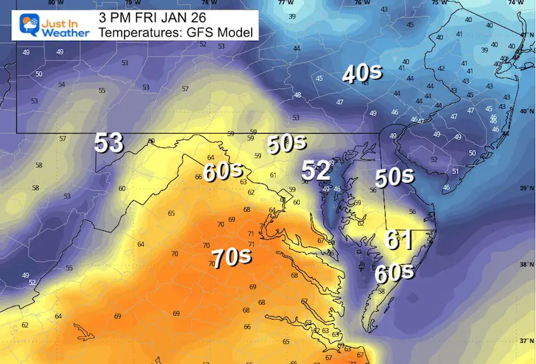
I have helped promote the temps surging into the 60s for this day… but not for everyone. In fact, it will be cooler by the water, and there may still be some rain showers.
Special Olympics Super Plunge
Almost 37% of my goal…. It’s CREEPING UP
This Friday, I will be doing 24 plunges in 24 hours at Sandy Point Park.
Some inland afternoon temps will be in the 60s, but the Chesapeake Bay water is down into the 30s. So locally it will still be chilly!
I hope you will consider supporting my efforts to reach this lofty goal!
This is my new friend Daniele, A Special Olympics Athlete and my inspiration!
Click the image to donate. Every little bit counts.

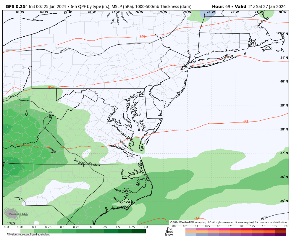
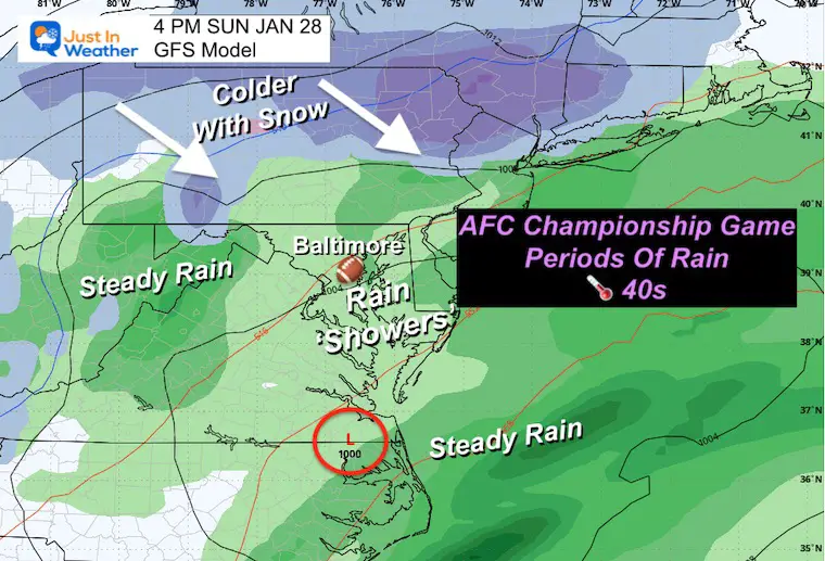
Here we see the potential rain showers on Friday… Then a break on Saturday with rain returning at night into Sunday for the Ravens AFC Championship Game. The interesting feature is the pull of colder air and the continued showing of snow early Monday morning…
This GFS Model is showing the developing rain Saturday night, then periods or waves of rain on Sunday. This model continues to bring in colder air and maybe snow early Monday. This would change overnight IF it verifies. As we get closer, it will be important to watch the local temperatures for any impact on the roads for stickage or if they stay wet.
Baltimore will have rain breaking up to showers for the game time in the afternoon. Temps will be cooling in the 40s… Weak Low Pressure will be passing South and then East off of the coast. This will pull in the colder air.
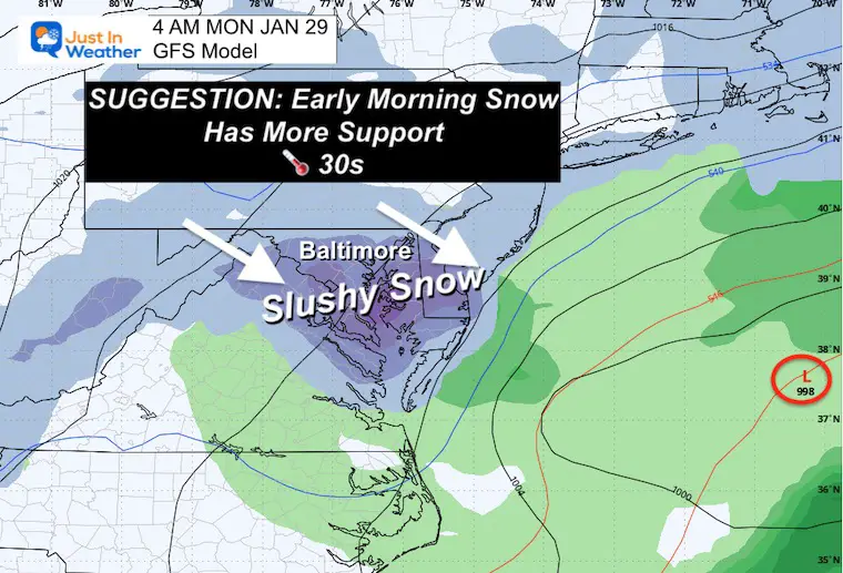
SUGGESTION WITH MORE SUPPORT
The GFS Model is still showing this while the European is not. So this is still not a promise, but I need to continue to show the possibility that an early morning slushy snow may fall.
Surface temps around Baltimore and south will remain just above freezing in the mid-30s. So the impact on roads (IF THIS HAPPENS) is a wild card.
After the rain today, there will be a break with leftover showers on Friday.
Maryland Special Olympic Super-Plunge begins at 10 AM. By the water, it will be colder, but inland areas have a chance to reach the 60s.
Sunday: Rain showers or periods of rain also mean it may not be consistent. It will be chilly and turning colder.
I am a little more confident in the expectation for slushy snow on Monday morning. Temps may stay above freezing near Baltimore and south… so the impact on roads is still in question.

Click to see more and ‘Book’ a visit to your school


Computer Models Support East Coast Storm Track

The latest NOAA report is confident in a Very Strong event. Possibly HISTORIC! This refers to the temperatures in the Pacific, with impacts on the US Winter Storm Track.

Winter Weather Folklore: Top 20 and more signals from nature for snow.
Winter Outlook 2024 From Two Farmers Almanacs Return to Cold and Snow
I am aware there are some spelling and grammar typos and occasional other glitches. I take responsibility for my mistakes and even the computer glitches I may miss. I have made a few public statements over the years, but if you are new here, you may have missed it: I have dyslexia and found out during my second year at Cornell University. It didn’t stop me from getting my meteorology degree and being the first to get the AMS CBM in the Baltimore/Washington region. One of my professors told me that I had made it that far without knowing and to not let it be a crutch going forward. That was Mark Wysocki, and he was absolutely correct! I do miss my mistakes in my own proofreading. The autocorrect spell check on my computer sometimes does an injustice to make it worse. I also can make mistakes in forecasting. No one is perfect at predicting the future. All of the maps and information are accurate. The ‘wordy’ stuff can get sticky. There has been no editor who can check my work when I need it and have it ready to send out in a newsworthy timeline. Barbara Werner is a member of the web team that helps me maintain this site. She has taken it upon herself to edit typos when she is available. That could be AFTER you read this. I accept this and perhaps proves what you read is really from me… It’s part of my charm. #FITF