Conditions: Baltimore, Maryland, 05/04/2024 11:20:02 pm
Temperature

52°

Cloudy

51°

Dew Point
Relative Humidity

97%

Feels Like

52°

Wind (E)

8mph

Air Pressure

30.23

Sun
Sun Rise

06:03 AM

Sun Set

08:03 PM

Day Length

14:00 Hours

Difference

2 min 7 sec gain

Moon
Moon Rise

04:08 AM

Moon Set

04:09 PM

Next: New Moon

May 07,2024

Moon Phase

Waning Crescent

Climate
Average Low

48°

71°

Average High
Record Low

34°


(1957)

91°


(2018)
Record High
Conditions

Wednesday August 10 Storm Simulation Update And Radar

NOAA
Flooding
Severe Weather
Forecast
Warnings

August 10 2022

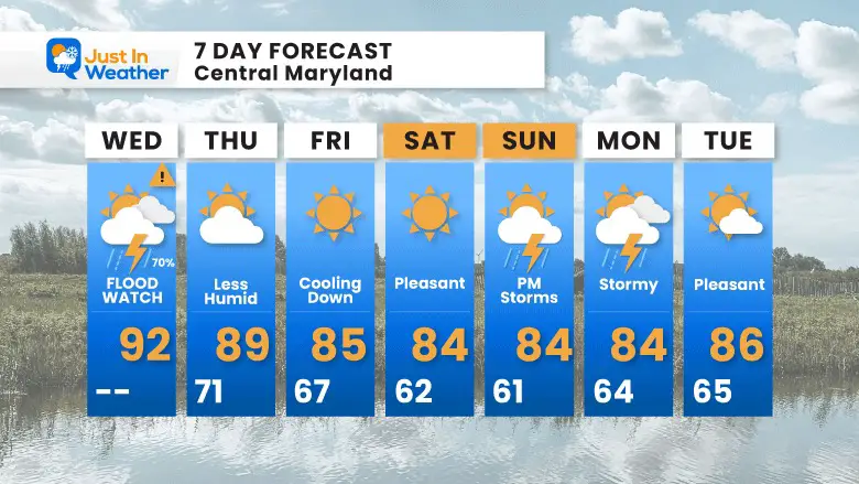
Wednesday Update at 11:40 AM

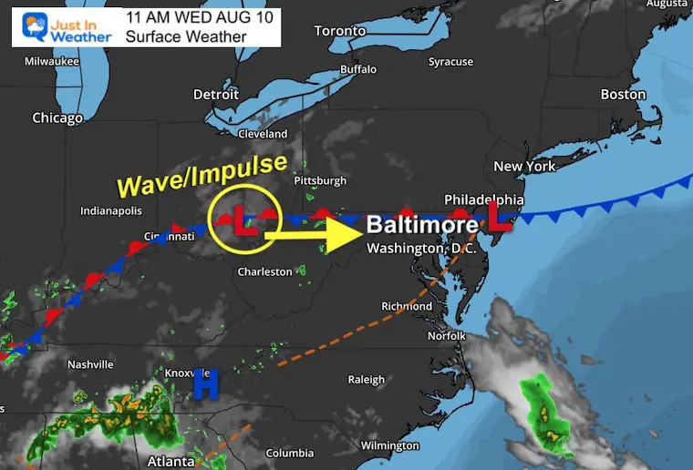
I feel like we have been here before: We are still under the influence boundary that will try to send showers our way. This is nearly stalled, otherwise known as a quasi-stationary front, and has waves of disturbances that can triggers clusters or lines of rain and storms. 

Today, it does look like one of these impulses will work off the high humidity and move through with a line of showers and thunderstorms. At best guess, metro areas can expect this to arrive between 4 PM and 8 PM.  

Below is the comparison to show the similarities and differences between the NAM 3 Km and HRRR Models, plus the Live Radar and Lightning Widget to track.

The NAM 3 Km is faster/earlier and focuses the bulk of energy to the south.

The HRRR Model is a few hours later, and involves more metro Baltimore.

Given the poor performance of the models this summer, I want to show both and consider the verification will be between them… with likely more coverage than shown.


Midday Set Up

The stationary boundary is stretched along the Maryland/Pennsylvania line. This position is why I am leaning towards the HRRR solution to include metro Baltimore in the storms today.


Temperatures 


Dew Point

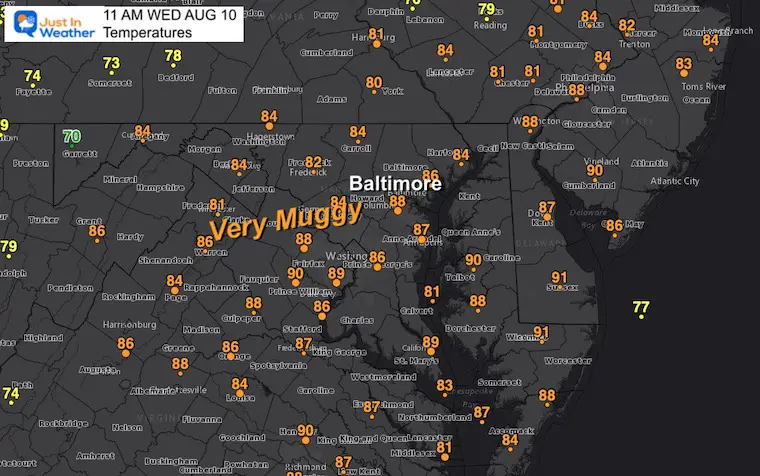
This is the true measure of moisture in the air. 

When above 70ºF it is humid, and supports tropical downpours when storms do develop. 


NOAA Flood Watch

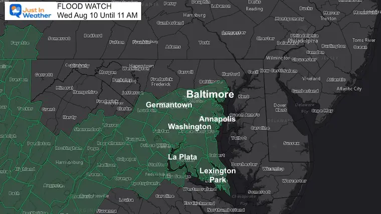
The potential to see rainfall of 1 to 3 inches can produce local flooding.

This product is from NOAA, but if the storms do track a little north closer to the stationary front, then we can see flooding in the northern Maryland counties as well.


Short Range Forecasting

The good news is that there is some agreement with the two short range models. The difference is in the timing. Here we see developing storms into metro Washington and Baltimore.

NAM 3 Km Model: 4 PM to 7 PM

HRRR Model: 6 PM to 8 PM

See the animation of each product below the Live Radar/Lightning Widget


Live Lightning and Radar Widget


Radar Simulations..

HRRR Model

This is the later solution, but more active for metro Baltimore. I am inclined to lean in this direction…

This shows the main storms forming by 3 or 4 PM


august-10-weather-storm-simulation-radar-hrrr-pm-12
august-10-weather-storm-simulation-radar-hrrr-pm-2
august-10-weather-storm-simulation-radar-hrrr-pm-4
august-10-weather-storm-simulation-radar-hrrr-pm-5
august-10-weather-storm-simulation-radar-hrrr-pm-6
august-10-weather-storm-simulation-radar-hrrr-pm-7
august-10-weather-storm-simulation-radar-hrrr-pm-8
august-10-weather-storm-simulation-radar-hrrr-pm-9
august-10-weather-storm-simulation-radar-hrrr-pm-10
august-10-weather-storm-simulation-radar-hrrr-pm-11
august-10-weather-storm-simulation-radar-hrrr-thursday-midnight
previous arrow
next arrow


NAM 3 Km

This is the faster solution with a split of energy showing the bulk farther south.

This shows the initial line forming in the mountains around or after 12 PM/Noon.


august-10-weather-rain-storm-simulation-nam-pm-12
august-10-weather-rain-storm-simulation-nam-pm-1
august-10-weather-rain-storm-simulation-nam-pm-2
august-10-weather-rain-storm-simulation-nam-pm-3
august-10-weather-rain-storm-simulation-nam-pm-4
august-10-weather-rain-storm-simulation-nam-pm-5
august-10-weather-rain-storm-simulation-nam-pm-6
august-10-weather-rain-storm-simulation-nam-pm-7
august-10-weather-rain-storm-simulation-nam-pm-8
august-10-weather-rain-storm-simulation-nam-pm-9
august-10-weather-rain-storm-simulation-nam-pm-10
previous arrow
next arrow


Connect With A Health Coach

From My Maryland Trek Team

Click the image or here for more info


7 Day Forecast


Hurricane Season Forecast: June 1 Through November 30

NOAA 2022 Hurricane Forecast- Above Normal Again


Forecast From Colorado State University

Atlantic Hurricane Forecast


Related Posts


NOAA Study: Reducing Air Pollution INCREASED Tropical Storms


Atlantic Tropical History: Maps of Origin Regions Every 10 Days

13_Tropical Storm Formation Sep11_20


Recent Storm Reports

May 22 Hail And Wind Damage

May 16 Large Hail Videos And Storm Tracking Map

Please share your thoughts, best weather pics/videos, or just keep in touch via social media

Facebook: Justin Berk, Meteorologist

Twitter: @JustinWeather

Instagram: justinweather


*Disclaimer due to frequent questions:

I am aware there are some spelling and grammar typos. I have made a few public statements over the years, but if you are new here you may have missed it:

I have dyslexia, and found out at my second year at Cornell.  It didn’t stop me from getting my meteorology degree, and being first to get the AMS CBM in the Baltimore/Washington region. 

I do miss mistakes in my own proofreading. The autocorrect spell check on my computer sometimes does an injustice to make it worse. 

All of the maps and information are accurate. The ‘wordy’ stuff can get sticky. 

There is no editor that can check my work when I need it and have it ready to send out in a newsworthy timeline. 

I accept this and perhaps proves what you read is really from me…

It’s part of my charm.