Conditions: Baltimore, Maryland, 05/17/2024 04:40:04 am
Temperature

63°

Cloudy

57°

Dew Point
Relative Humidity

81%

Feels Like

63°

Wind (N)

5mph

Air Pressure

29.85

Sun
Sun Rise

05:50 AM

Sun Set

08:15 PM

Day Length

14:25 Hours

Difference

1 min 43 sec gain

Moon
Moon Rise

02:42 PM

Moon Set

03:03 AM

Next: Full Moon

May 23,2024

Moon Phase

Waxing Gibbous

Climate
Average Low

52°

74°

Average High
Record Low

33°


(1956)

93°


(2017)
Record High
Conditions

February 12 Mild Today Then Cold and Snow Looking A Little Stronger

snow forecast
Winter Weather
Forecast

Saturday February 12- Morning Report

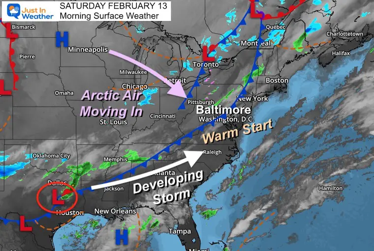
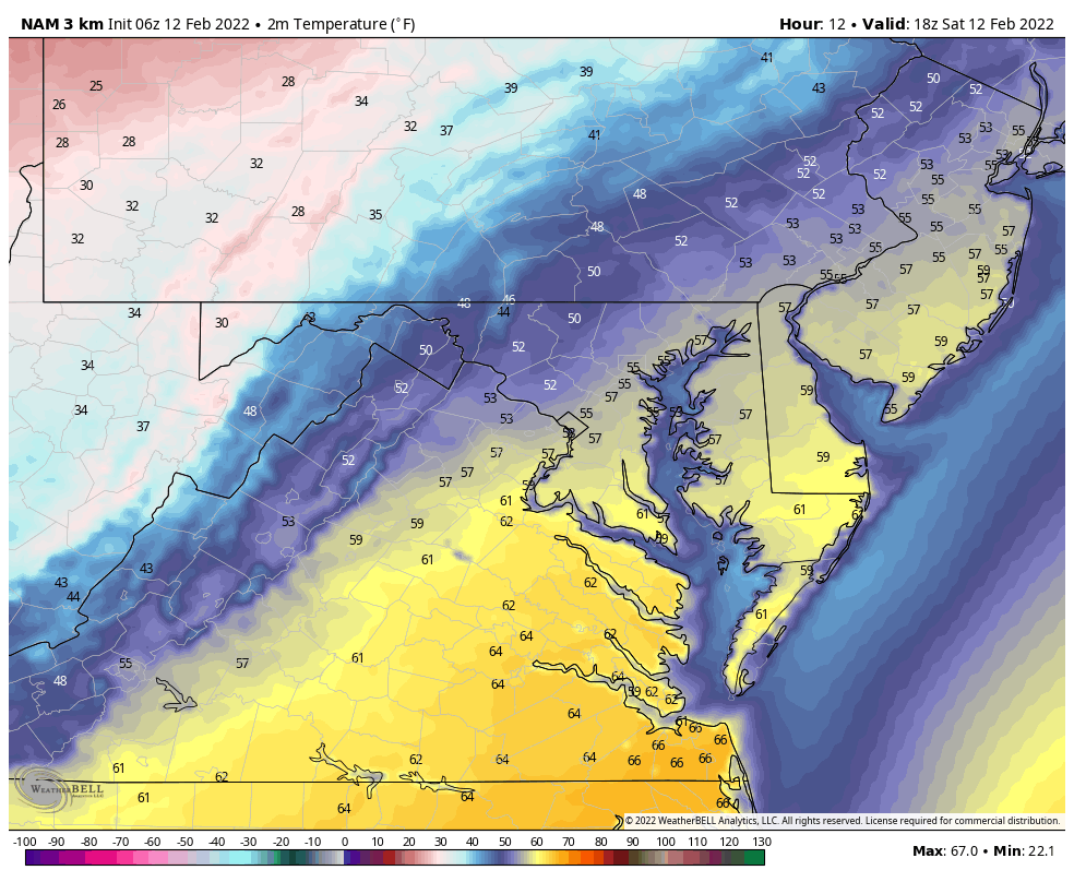
Our weekend is starting mild but I am promise it will not end that way.  After two days in the 60s, it may be hard for some to imagine arctic cold being enough to support any snow stockage. But the latest information is supporting that. So for others, it is just February in Maryland (and the Mid Atlantic).

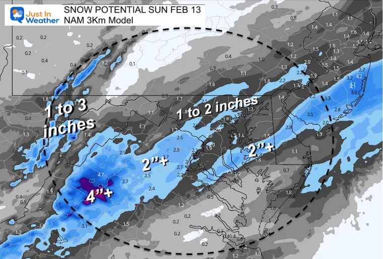
I am focusing on the NAM 3 Km Model now, which performs best within 1-2 days of the event. It is showing a little bump in snow expectations… and the timing of the freezing temps before sunrise supports stickage.


Headlines

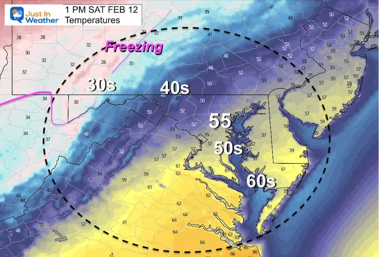
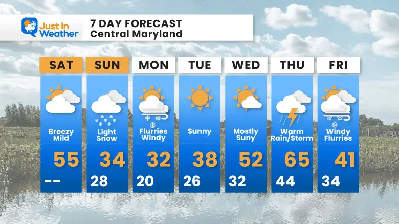
  • Mild today with more clouds. Winds and cooler later in the day.
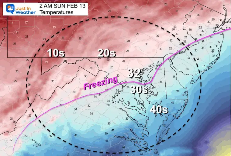
  • Tonight: Colder air arrives, freezing temps after midnight. 
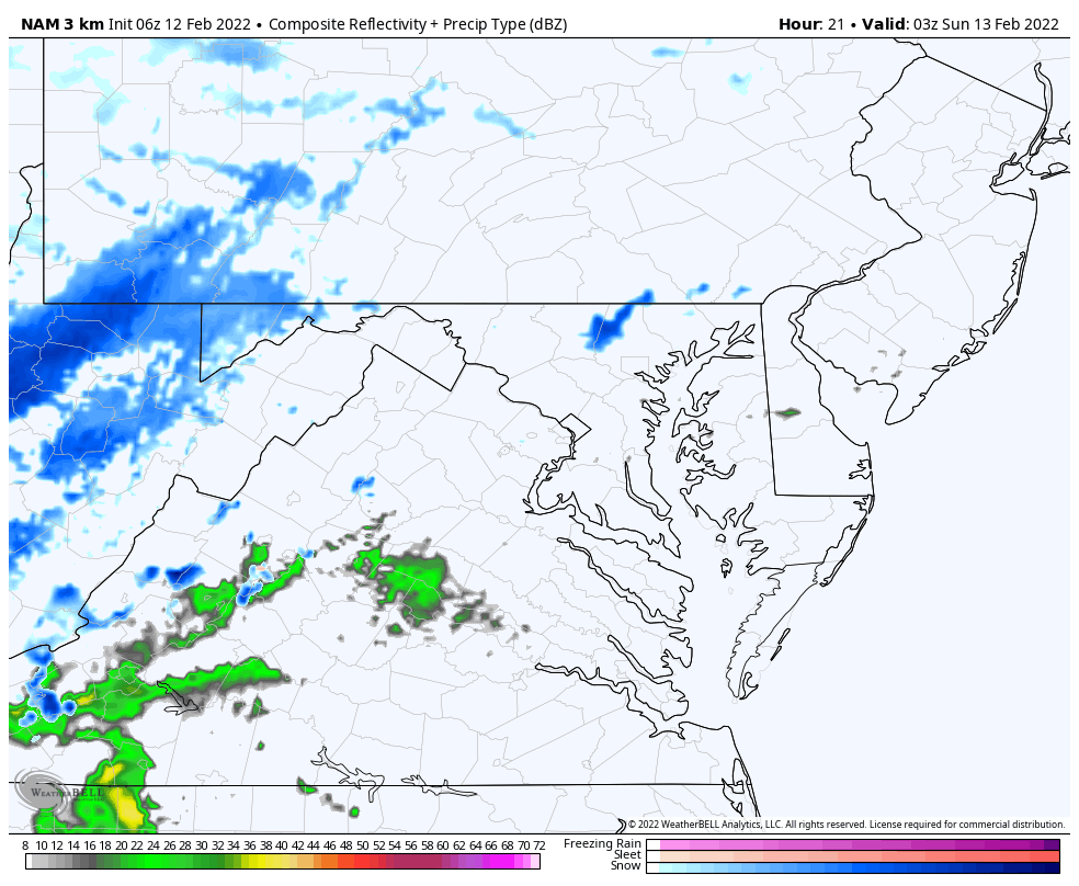
  • Snow develops within an hour or two of midnight. 
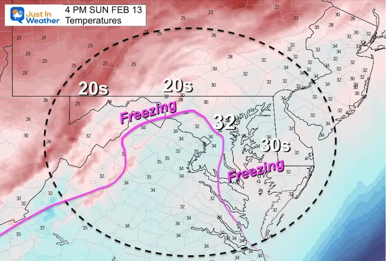
  • Sunday Snow: Should be widespread at daybreak, with stickage. 
  • Sunday Afternoon: Snow ends for most, but continues in So. MD and Delmarva. 
  • Super Bowl Plans: Should be OK, except near beaches. Plan for icing
  • Next week: Cold start, then even warmer ending the week. (Winter not done yet)


Morning Set Up

 A cold front will be crossing the region today. The arctic air will filter in later today and tonight.

Low Pressure in the South will ride and develop along the front.

The upper level energy to develop this will happen tonight and Sunday over the Mid Atlantic.


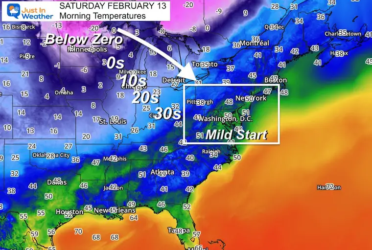
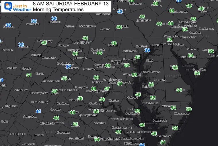
Morning Temperatures

Arctic Air behind the front drops off dramatically. This is fuel for the storm. 


Local Morning Temps


UPDATE: NEW POST SATURDAY NIGHT

Click here to see:

Snow Developing: Tracking Freezing Line And Snow Timeline


Afternoon Temperatures


Temperature Animation

1 PM Sat to 4 PM Sun: Watch The DROP This Afternoon 

(Closer look at key time frames and snow below)


February-12-weather-temperatures-freezing


Weather Almanac: Climate Data at BWI

TODAY February 12

Seasonal Snow: 13.3”; 

+4.7″ ABOVE AVERAGE


Normal Low in Baltimore:  26ºF

Record +5ºF in 1899


Normal High in Baltimore: 44ºF

Record 73ºF 1999


Sunday Storm

Let’s Start With the Temperatures 

2 AM Sunday

The freezing line should be dropping south of Baltimore at this time.


8 AM – After Sunrise

The freezing line reaches southern Maryland and south of Cambridge on the Eastern Shore.


Late Afternoon

Temperatures recover to near Freezing around Baltimore, with s thaw around metro Washington. 

Concern on Delmarva with near freezing temps. Daytime roads may be wet, but will ice over after 5 PM through evening.


NEW Forecast Animation:

NAM 3 Km Model 10 PM Sat to 8 PM Sun

We can see some showers trying to break out tonight, but develop and expand after midnight.

Snow should be widespread by morning, and then push to Delmarva in the afternoon and early evening at the beaches. 

It will end around Baltimore by 10 AM, rhino Annapolis closer to Noon.


February-12-weather-snow-sunday-nam


Prior Model Timelines

Here are the hourly timelines I posted in my prior report. I will update this shortly.


Radar Simulation (Morning) —-> slider

2 AM to 11 AM

february-11-weather-snow-super-bowl-sunday-radar-am-2
february-11-weather-snow-super-bowl-sunday-radar-am-3
february-11-weather-snow-super-bowl-sunday-radar-am-4
february-11-weather-snow-super-bowl-sunday-radar-am-5
february-11-weather-snow-super-bowl-sunday-radar-am-6
february-11-weather-snow-super-bowl-sunday-radar-am-7
february-11-weather-snow-super-bowl-sunday-radar-am-8
february-11-weather-snow-super-bowl-sunday-radar-am-9
february-11-weather-snow-super-bowl-sunday-radar-am-10
february-11-weather-snow-super-bowl-sunday-radar-am-11
previous arrow
next arrow

Radar Simulation (Afternoon/Evening) —> slider

february-11-weather-snow-super-bowl-sunday-radar-pm-12
february-11-weather-snow-super-bowl-sunday-radar-pm-1
february-11-weather-snow-super-bowl-sunday-radar-pm-2
february-11-weather-snow-super-bowl-sunday-radar-pm-3
february-11-weather-snow-super-bowl-sunday-radar-pm-4
february-11-weather-snow-super-bowl-sunday-radar-pm-5
february-11-weather-snow-super-bowl-sunday-radar-pm-6
february-11-weather-snow-super-bowl-sunday-radar-pm-7
february-11-weather-snow-super-bowl-sunday-radar-pm-8
previous arrow
next arrow


Snow Forecast: NAM 3 Km Comparison

New Forecast

The update here may look like the stripe of heavy snow is broken, but the potential for nearly 2 inches of snow includes Frederick, Westminster, and Baltimore on the north end.


Compare To

Last Forecast

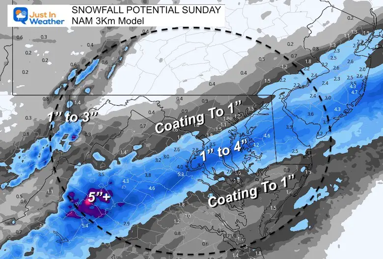
The middle strip looks more impressive here, but the northern edge is lower. Notice Baltimore in this plot is half the amount with 1″ and less to the northwest.


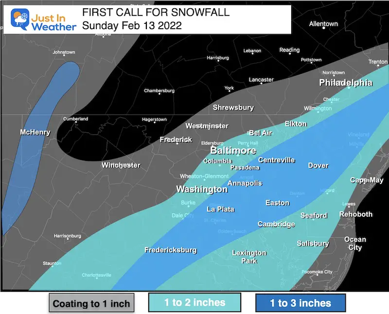
My First Call For Snowfall

If I have any adjustments, I will post that and share with you in my afternoon report.


Central MD/Metro Baltimore

Biggest impact should be in the morning.


Southern Maryland/Delmarva

Snow lingers longer into the afternoon or evening by the beaches. There will be ore snow in this area, but warm ground to counter stickage.  This is also the region that has a better chance to still be wet by evening, then ice up.


7 Day Forecast

Monday: Flurries with the cold winds.

Warmer Wednesday and Thursday.  Temps into the 60s with thunderstorms possible.

I need to emphasize: Winter is NOT done! I’ve heard that from conviction from a few people… But it’s not my impression.

In fact, what I have often seen is that in late winter when we get a surge of well above normal temps, it is often countered by a return of winter weather to balance it out.  It may take another week or two, but it’s too early to throw in the towel. 


Weather posts straight to your inbox

Sign up and be the first to know!


ALSO SEE


What is Faith in the Flakes: History of December 5th Snow


ALL FITF GEAR


FITF THUNDERSNOW


Winter Outlook Series:

My Call For Snowfall


Last Winter Recap: My Old Outlook And Your Grades Of My Storm Forecasts

Winter Weather Page – Lots of resources


Solar Cycle Increasing Sunspots Suggests More Snow


Comparing 4 Different Farmer’s Almanacs: Majority colder winter outlook than NOAA


NOAA Winter Outlook- But Read The Fine Print


Signals For Early Start To Winter In November


Winter Outlook Series: La Nina Double Dip


Nor’easters May Give Hint For Winter La Nina Pattern


Winter Folklore Checklist


Please share your thoughts, best weather pics/video, or just keep in touch via social media

Facebook: Justin Berk, Meteorologist

Twitter: @JustinWeather

Instagram: justinweather


*Disclaimer due to frequent questions:

I am aware there are some spelling and grammar typos. I have made a few public statements over the years, but if you are new here you may have missed it:

I have dyslexia, and found out at my second year at Cornell.  I didn’t stop me from getting my meteorology degree, and being first to get the AMS CBM in the Baltimore/Washington region. 

I do miss my mistakes in my own proofreading. The autocorrect spell check on my computer sometimes does an injustice to make it worse. 

All of the maps and information are accurate. The ‘wordy’ stuff can get sticky. 

There is no editor that can check my work when I need it and have it ready to send out in a newsworthy timeline. 

I accept this and perhaps proves what you read is really from me…

It’s part of my charm.

#FITF