February 11 2022
Friday Night Update
I should have known better. In my afternoon report, I posted my first call for snowfall. Considering that Baltimore’s BWI hit 60ºF yesterday and 67ºF today. The record high temp for this date was 72ºF back in 1887. For what it’s worth, Baltimore still picked up an additional 6.8” of snow that March.
When I say Winter is not done yet, I have historical evidence to support it.
But I truly should have expected the snarky responses I got. Some said this is a ‘nothing burger’, or ‘a lot of hype for nothing’. Even my son heckled me when I said how much we might get. He looked me in the eyes and said he ‘hates THIS winter’. But then he laughed and said he loves me. So, I still have that.
Well, it really will snow Sunday, and it had to be addressed. In fact, for a good part of Maryland and Delmarva it will be snowing much of that day. See of those places may have wet roads, but ice up quickly in the evening.
So let’s take a closer look.
I wanted to help tell the story of the timeline and temperatures in a different way. I hope it translates on this screen for you to help you with the expectations.
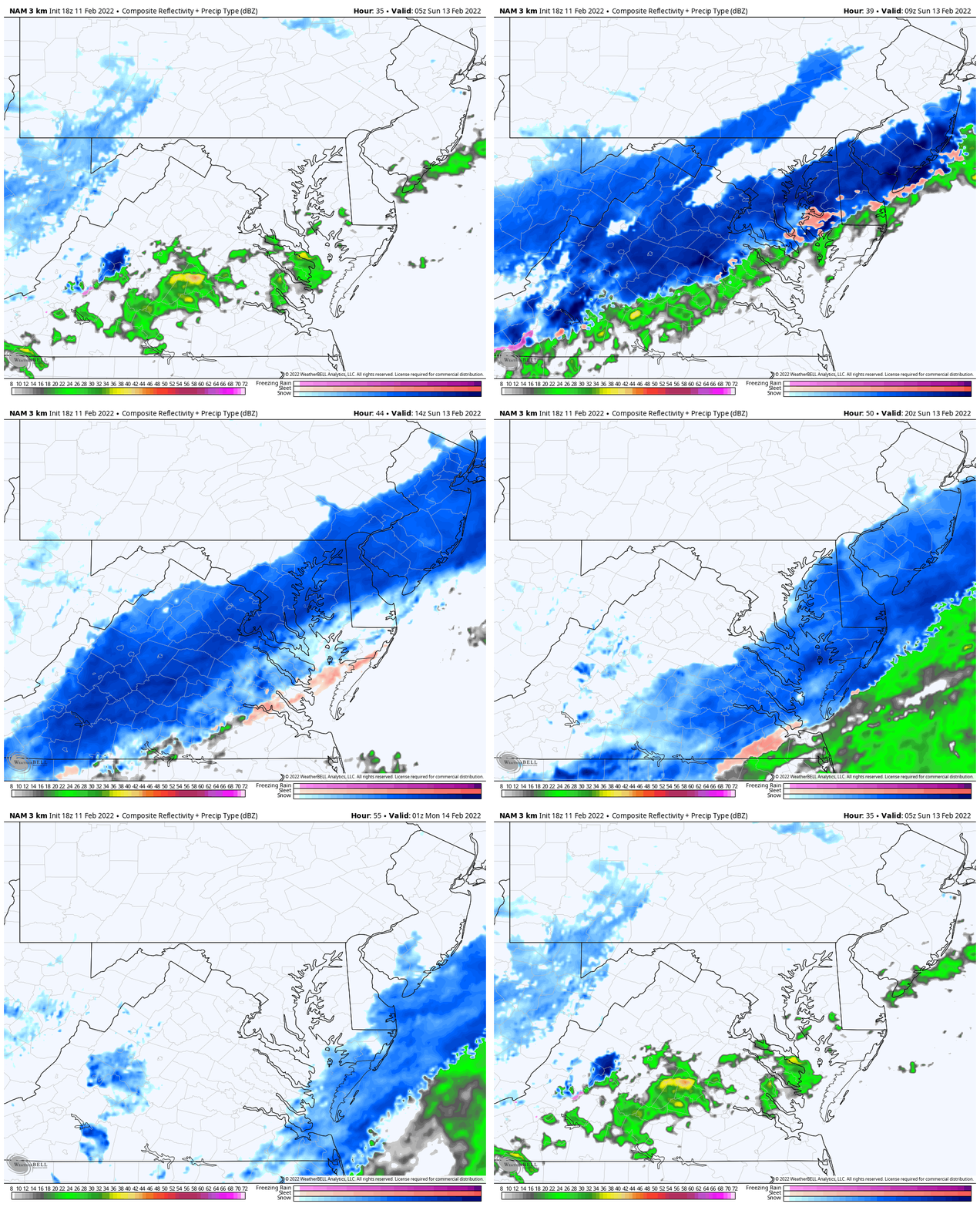
I’ve included new model simulation animation, two sliders dedicated to the morning and afternoon/evening. Also the temps at key time frames.
At the bottom, I have my first call for snowfall, in case you missed it. Also snow forecast maps from four different computer models.
Saturday Afternoon: Yes, Temps will be in the mid 50s. That’s expected…
Saturday Night: Snow begins….
Sunday: It will be snowing in the morning is many areas, and shift slowly all day across southern Maryland and Delmarva
Sunday Night: Deep Freeze!
NAM 3 Km Model
Radar Simulation Animation
Sunday 12 AM (midnight) to 8 PM
(hourly timeline sliders are below)
NEW REPORT
Click to see: Saturday Feb 12 Morning Report and Update
UPDATE!
Click to see:
EXPANDED Winter Weather Advisory AND My UPDATED Snow Forecast Map
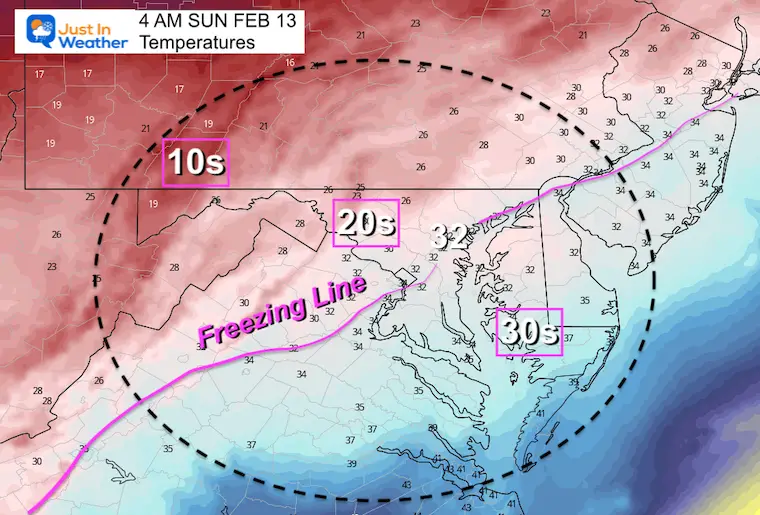
Temperatures Will Be Falling
12 AM – Midnight
The freezing line will still be northeast of Baltimore… So any initial flakes won’t be the problem. It will develop over a couple of hours.

4 AM
The freezing line should be reaching or getting close to Baltimore. This will help with stickage. But it may take some time to chill the pavement.
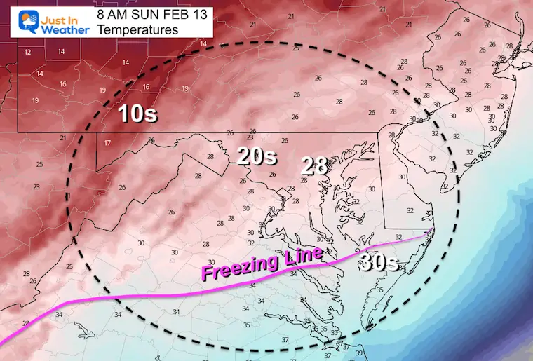
8 AM – After Sunrise
The freezing line is expected to push into southern Maryland… But with the region getting warmer temps for longer on Saturday, the stickage on roads may be questionable. But the snow has a fighting chance.
Radar Simulation (Morning) —-> slider
2 AM to 11 AM
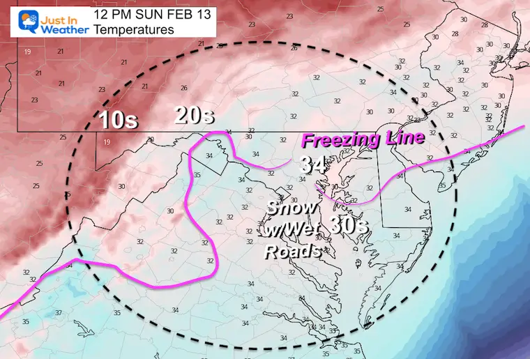
Temperatures at Noon
The snow will be ending in Baltimore, but lingering in southern Maryland and Delmarva… These daylight hours with snow are likely to have wet roads in southern Maryland and Delmarva… until sunset.
Radar Simulation (Afternoon/Evening) —> slider
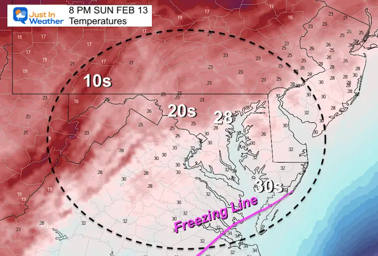
Temperatures / Evening
This is when it gets tricky… Especially for southern Maryland and Delmarva. With the snow lingering longer, the wet pavement will have a chance to ice up after dark.
If you are hosting a Super Bowl Party, you may want to considering salting your steps, walk/driveway.
If you are traveling, be careful heading out as it will be COLDER and cold be icy.
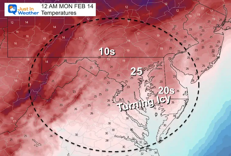
Temperatures At Midnight
The cold air will be filling in all across our region. As you might image, it will be getting colder through morning.
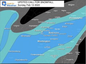
How Much Snow? May First Call
Please note this is for what may be measured.
There will be some melting on the pavement, so a little less to salt or plow.
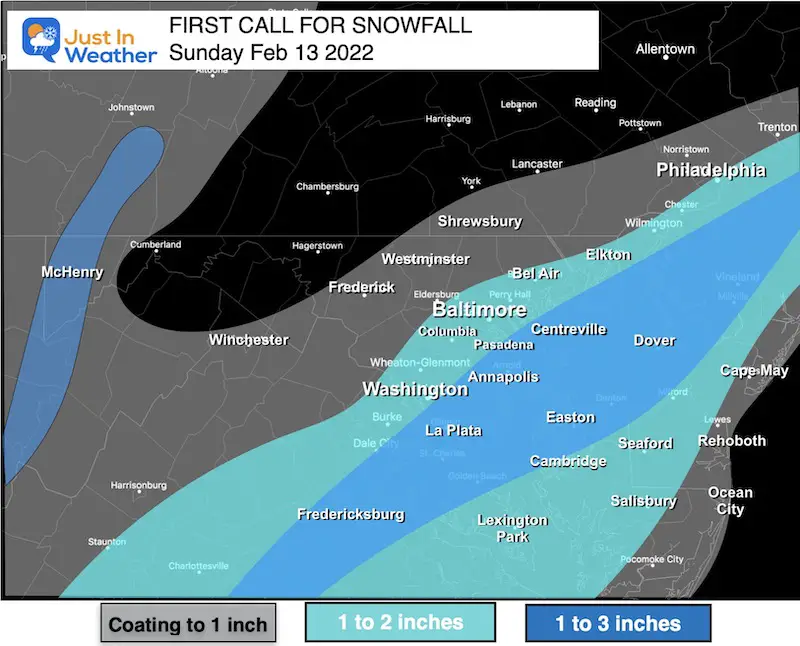
Central MD/Metro Baltimore
Biggest impact should be in the morning.
Southern Maryland/Delmarva
Snow lingers longer into the afternoon or evening by the beaches. There will be ore snow in this area, but warm ground to counter stickage. This is also the region that has a better chance to still be wet by evening, then ice up.
What are ‘They’ Saying?
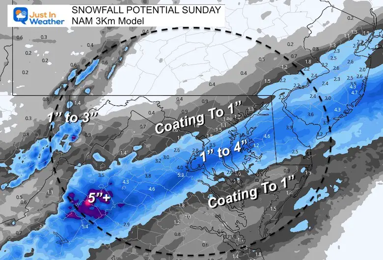
Here’s a look at the collection of computer model snow forecasts.
NAM 3 Km (the model I showed above)
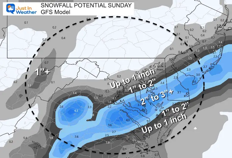
GFS Model
This does show enhancement in a narrow band between moderate snow and the small window for stickage early in the morning.
Canadian GEM Model
This is similar to the GFS, but does show a little enhancement for the beaches with stickage Sunday evening.

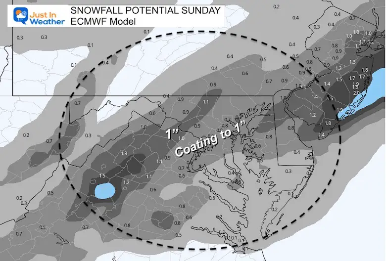
European ECMWF
This is the most disappointing result if you want snow. It is the outlier, and the least likely solution at this time.
Summary:
It will snow and it is needed to explore considering two things:
- The abrupt change from the warm days we are in now.
- It will be Super Bowl Sunday. There will be more people traveling than a normal weekend day and any weather impact is what I want to help you be aware and prepare if needed.
The biggest impact in central Maryland/metro Baltimore should be on Sunday morning. With the exception of far western Maryland, yes the normally snowier inland areas of Maryland and southern PA miss the bulk of this.
More snow will fall during the day from Annapolis to southern Maryland and Delmarva! But the mid day should have wet roads.
However, the falling temps will allow for a chance of icing in the evening.
We do have a warm pattern setting up next week, and perhaps to end February, but we should not close the door on winter yet.
#FITF
Weather posts straight to your inbox
Sign up and be the first to know!
ALSO SEE
What is Faith in the Flakes: History of December 5th Snow
ALL FITF GEAR
FITF THUNDERSNOW
Winter Outlook Series:
Last Winter Recap: My Old Outlook And Your Grades Of My Storm Forecasts
Winter Weather Page – Lots of resources
Solar Cycle Increasing Sunspots Suggests More Snow
Comparing 4 Different Farmer’s Almanacs: Majority colder winter outlook than NOAA
NOAA Winter Outlook- But Read The Fine Print
Signals For Early Start To Winter In November
Winter Outlook Series: La Nina Double Dip
Nor’easters May Give Hint For Winter La Nina Pattern
Winter Folklore Checklist
Please share your thoughts, best weather pics/video, or just keep in touch via social media
Facebook: Justin Berk, Meteorologist
Twitter: @JustinWeather
Instagram: justinweather
*Disclaimer due to frequent questions:
I am aware there are some spelling and grammar typos. I have made a few public statements over the years, but if you are new here you may have missed it:
I have dyslexia, and found out at my second year at Cornell. I didn’t stop me from getting my meteorology degree, and being first to get the AMS CBM in the Baltimore/Washington region.
I do miss my mistakes in my own proofreading. The autocorrect spell check on my computer sometimes does an injustice to make it worse.
All of the maps and information are accurate. The ‘wordy’ stuff can get sticky.
There is no editor that can check my work when I need it and have it ready to send out in a newsworthy timeline.
I accept this and perhaps proves what you read is really from me…
It’s part of my charm.
#FITF


