


May 5 Soggy And Chilly Start With More Rain During The Week Ahead
Sunday May 5 Morning Report We are stuck in this muck! The wet weather pattern continues with a soggy start this Sunday morning. The rain will try to break up…
February 3 2022
Thursday Evening Update
As I suggested in my earlier post, the storm system crossing the country has slowed down. The front in Pennsylvania is now considered quasi-stationary. It appears to be getting stuck in the mountains, thanks in part to the orientation. The result will allow slightly warmer air in tonight. 50s to near 60ºF will reach into parts of our region. The colder air will arrive on Friday, just a little later.
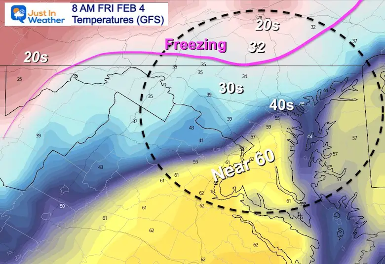
The National Weather Service pushed the timing of the Winter Weather Advisory back 3 hours in central Maryland. This is based off of the arrival of the freezing line after sunrise. There will still be icing, but the dynamics will change. I will explain in more detail below.
Also, I hope to address the many questions I have been receiving to help you get what you expect.
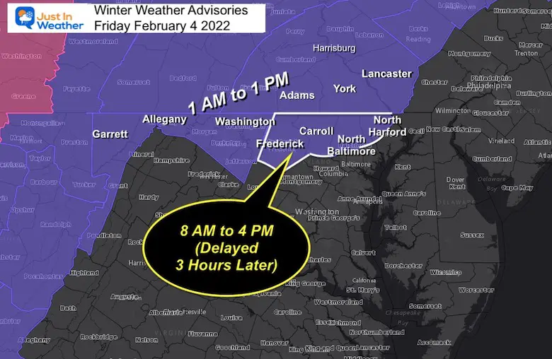
Timing the arrival of cold air just before or after sunrise will limit the impact of icing on roads.
Places that do reach the 50s overnight, will take a little longer for roads to chill down. But there will be the risk of ice growing through the day and evening.
BWI will not be affected by ice in the morning. However, there is a large area that will be, and other cancellations or delays could have a cascading effect. So it best to plan for possible delay to your plans, then be pleased if it’s on time.
Icing may still occur Friday evening, and shown below.
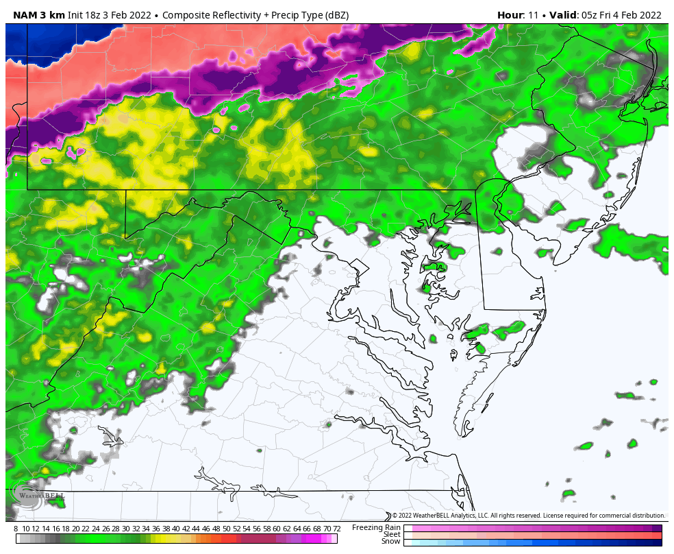
Snow d ice have reached northwestern PA, but that front is nearly stalled.
Notice the highlight of ‘Warming’ from the south… Check out the temps below. This is part of the block slowing down the front.
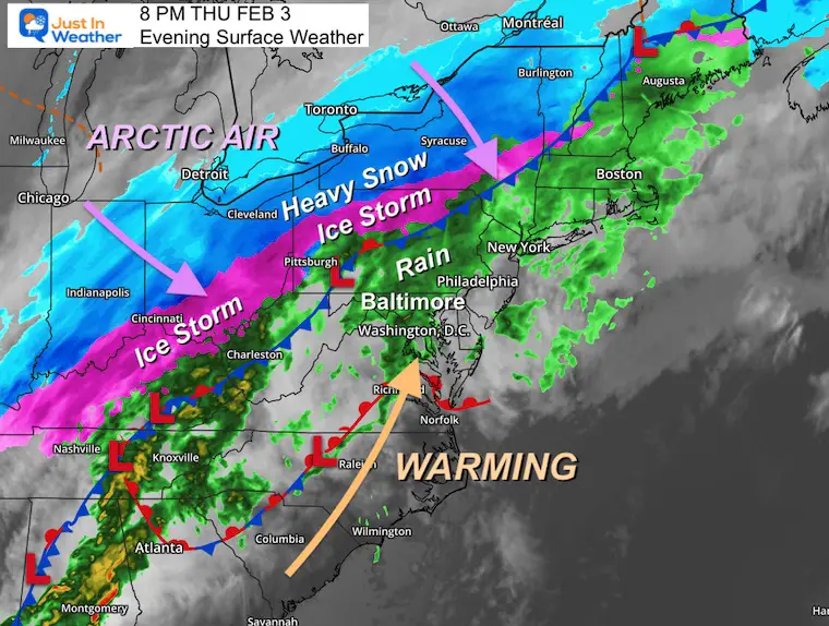
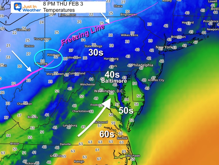
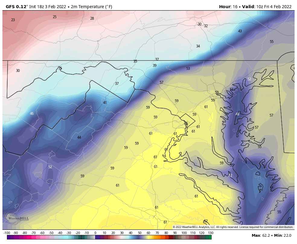
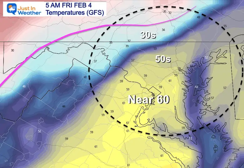
The ‘Warming’ region is currently in the 50s and 60 across Southeast Virginia. That is the warm air that will push into center Maryland tonight.
The cold air and freezing line in PA will slowly drop southeast and expected to possibly reach western Maryland to York, PA before sunrise. (see the forecast maps below).
This is still not a lock, but I am getting a better idea that there should be a longer time for icing to occur.
Notice the warm surge in Baltimore to the upper 50s. THAT alone will require more cold hours for the ground to catch up when the freeze arrives. This means metro Baltimore stays wet.
I am working to have my full update ready in the 6 AM hour
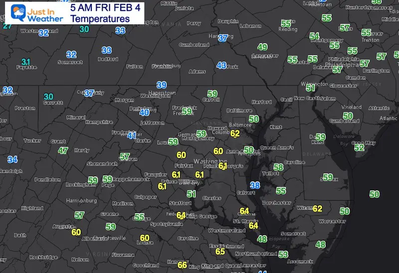
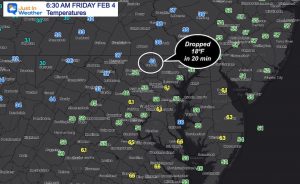
Westminster dropped 18ºF in 20 minutes (6:00 Am to 6:20 AM)
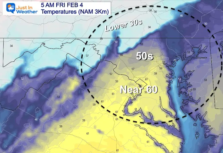
5 AM to 12 PM
Yes, that is a 59ºF spot on Baltimore at 5 AM, then a quick drop!
The is still the colder model… but only brings 32ºF to York PA and near the Maryland line between 6AM and 8 AM. Then drops northern areas into the 20s through noon.
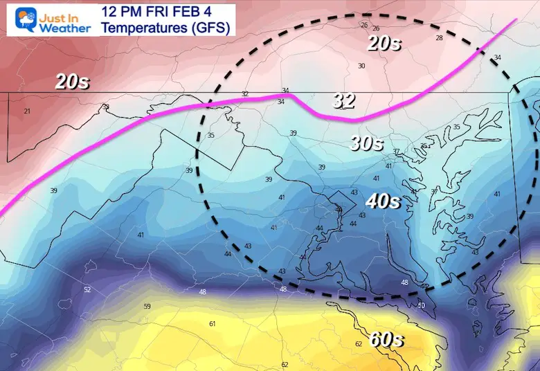
This has been slower with the colder air.
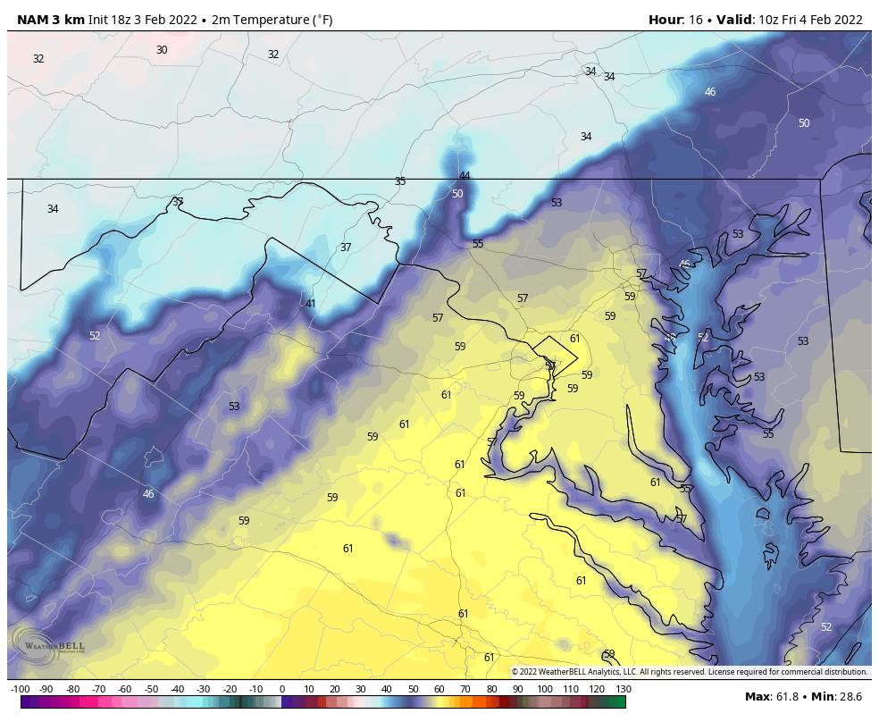
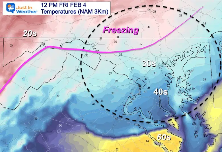
12 AM to 6 PM Friday
This is the warmer NAM 3 Km Model
It is having trouble with the southern edge of ice reaching Maryland early, but redevelops during the day.
It also keeps the rain around longer into the afternoon.
Using the warmer/slower NAM 3 Km, we still still freezing temps arrive to Baltimore and near Washington and Annapolis between 6 PM and 7 PM.
With the ground still wet from longer rainfall, it is very possible for untreated surfaces to ice over near and after sunset.
Southern Maryland and Lower Eastern Shore may start icing after 8 PM.
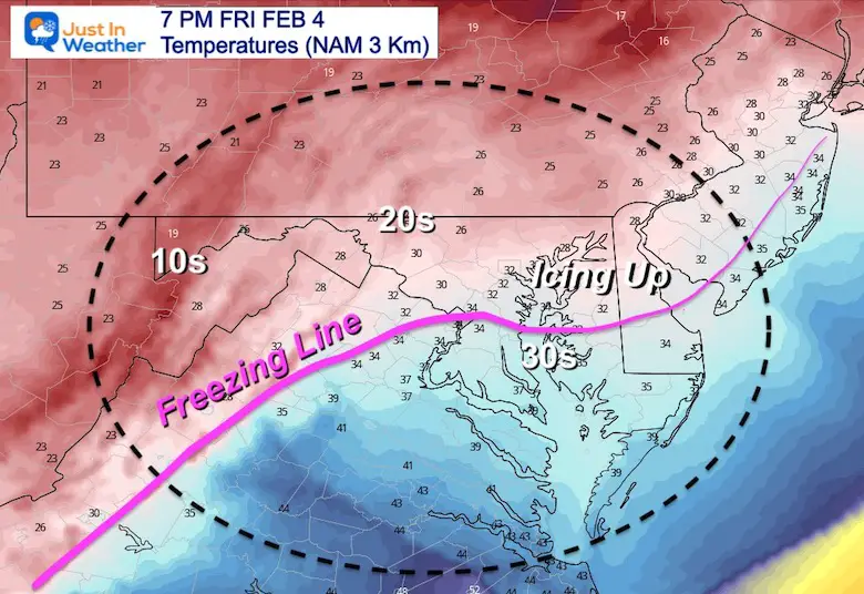
The warming night and slower arrival of colder air means delayed icing. Impact on the morning is still very plausible across southern PA counties to western Maryland. But, Central Maryland may get through the morning commute with wet roads, then in the ‘Advisory’ area there will be some icing during the day.
Rain will linger through the afternoon, leaving wet ground for the freezing temps in the evening. Central Maryland including metro Baltimore should plan for some icing between 5 PM and 7 PM. Then icing may develop into Southern Maryland during the evening.
I will be up early to update the condition and if there are any adjustment. See you then.


Last Winter Recap: My Old Outlook And Your Grades Of My Storm Forecasts


*Disclaimer due to frequent questions:
I am aware there are some spelling and grammar typos. I have made a few public statements over the years, but if you are new here you may have missed it:
I have dyslexia, and found out at my second year at Cornell. I didn’t stop me from getting my meteorology degree, and being first to get the AMS CBM in the Baltimore/Washington region.
I do miss my mistakes in my own proofreading. The autocorrect spell check on my computer sometimes does an injustice to make it worse.
All of the maps and information are accurate. The ‘wordy’ stuff can get sticky.
There is no editor that can check my work when I need it and have it ready to send out in a newsworthy timeline.
I accept this and perhaps proves what you read is really from me…
It’s part of my charm.
#FITF