


May 1 Weather Gradual Cooling Trend Will Bring Rain Into The Weekend
Wednesday, May 1 Morning Report One of the marks of May Day is an ancient European holiday celebrating the start of summer. It feels like we have had our taste…
Monday January 31 2022
Night Report
We are about to close out the month of January in a way many doubted was possible. Baltimore for example has 13.3 inches of snow, half of which fell this month. The monthly temps have been almost 2 degrees below normal, and to match that seasonal total to date is 4.4 inches above normal snow.
Before I get to the interesting forecasting this week, I need to address the holiday: Wednesday is Groundhog Day. While the nation will celebrate Punxsutawney Phil, The National Weather Service in State College PA is already throwing shade on Twitter today. Are they jealous of the attention?
It is the #GroundhogDay edition of #MythBusterMonday! Can Punxsutawney Phil accurately predict the arrival of spring? Since he is only right less than half of the time, you are better off to flip a coin! Or even using NWS forecasts 👀 https://t.co/LXslk2bHut #PAwx pic.twitter.com/2PtawGhGdP
— NWS State College (@NWSStateCollege) January 31, 2022
As we enter February and the next storm tracks to our west, we will get a warm up to the 50s with rain. But the cold air is deep and wants to return in time to make things interesting.
So here’s the predicament, and I can’t even believe I am saying this:
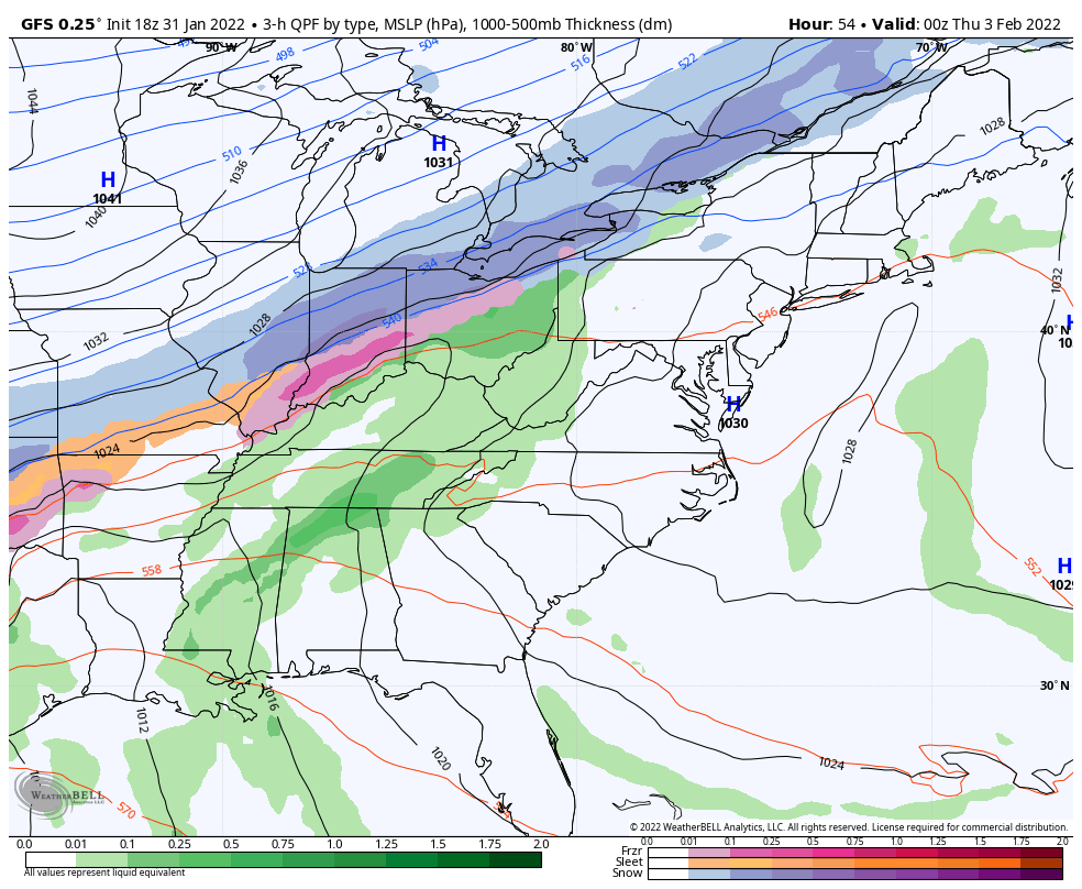
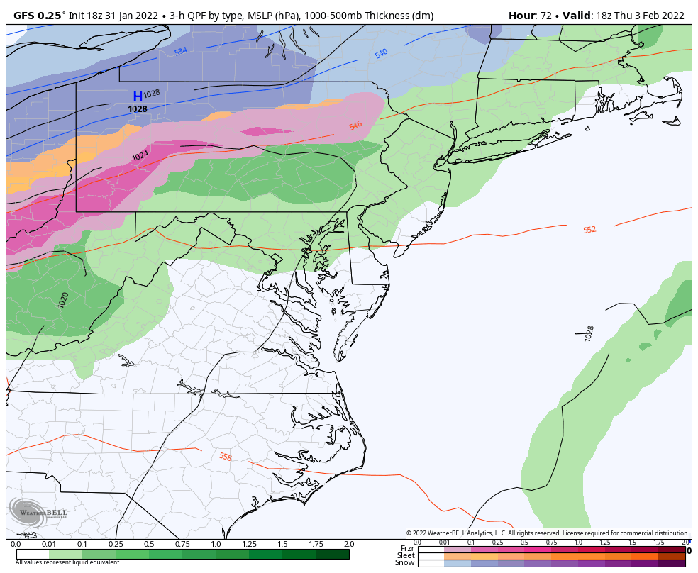
The GFS Model has performed remarkably well this month. So, we must respect what it is showing us at the end of the storm on Friday.
The GFS Model is plotting arctic air behind the cold front passing through Maryland while the precipitation is still here. That leaves a a large band of freezing rain and sleet to move through our region.

Here is the GFS Model at 7 AM showing the freezing line south of Annapolis, with 20s through much of central Maryland to southern PA inland from Baltimore.

Do you remember January 20. It was a Thursday morning, a week and a half ago. We had another “Arctic Boundary” expected to change our rain to ice and snow during yet another morning commute.
Atmospheric Memory? My theory continues to work two ways:
That time, the cold air was delayed by just a few hours, leading to wet roads when the snow did arrive and a waste of a day off for many schools.
The ECMWF Model is about 200 miles behind on the progress of the icy mix. Here at 7 AM it shows the freezing rain entering Garrett County to possibly Harrisburg and York in PA. But most of Maryland still in the rain.
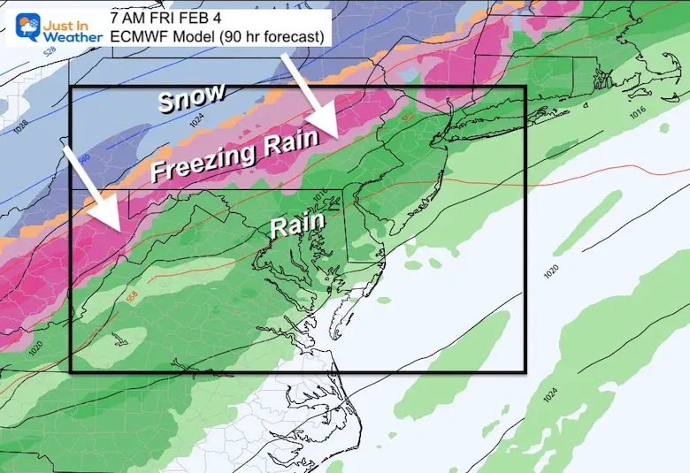
This European Model shows the freezing line through Hagerstown MD and York PA. Much different than the Annapolis plot with the GFS.
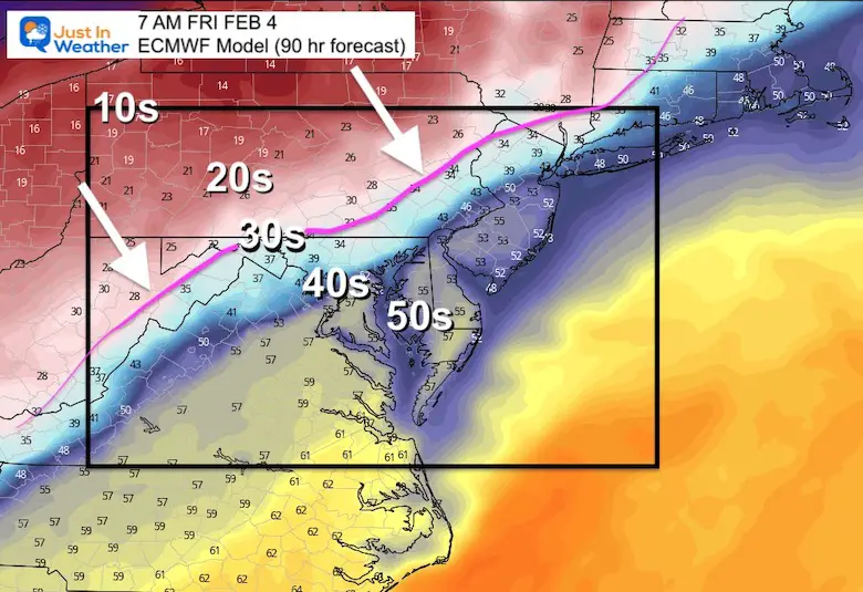
Here’s a closer look at the 7 AM Friday temperatures comparing these two models side by side.

While the GFS has performed well, it did lose out to the European Model with the closer track for the blizzard this past weekend.
At this point, I have to lean on the European Model’s later arrival. But, I give it a 55% to 45% edge. That means I expect something in between the two solutions may end up verifying.
That is the reason I am writing this post! I will NOT sound the alarm or push the hype button. However, it is worth watching all week and having a backup for any plans at that time.
I also hope this is time for schools to consider IF this verifies to first call a delay an reassess as the impact of falling temps during travel time is fickle.
Here are the GFS Model animations to view
7 PM Wed to 10 PM Fri
1 PM Thu 10 PM Fri
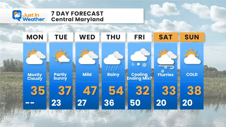
This was the 7 Day Forecast I issued this morning… Notice Friday starting with 50 in the morning and ending at 32ºF. I tried to split the difference and keep the idea of ‘Ending Mix”.
Faith in the Flakes!
*Disclaimer due to frequent questions:
I am aware there are some spelling and grammar typos. I have made a few public statements over the years, but if you are new here you may have missed it:
I have dyslexia, and found out at my second year at Cornell. I didn’t stop me from getting my meteorology degree, and being first to get the AMS CBM in the Baltimore/Washington region.
I do miss my mistakes in my own proofreading. The autocorrect spell check on my computer sometimes does an injustice to make it worse.
All of the maps and information are accurate. The ‘wordy’ stuff can get sticky.
There is no editor that can check my work when I need it and have it ready to send out in a newsworthy timeline.
I accept this and perhaps proves what you read is really from me…
It’s part of my charm.
#FITF


Last Winter Recap: My Old Outlook And Your Grades Of My Storm Forecasts


