Thursday January 20 2022
9:30 AM
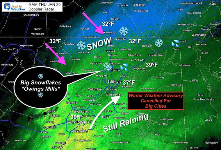
Rain has changed to snow this morning, in the inland areas. The hardest thing with this event has been about the timing. I hope I conveyed that message in my reports. This was set up to happen during the morning commute, and it looks like the change over for metro areas is about an hour or later that expected. School calls were made to not risk this happening an hour earlier and getting caught instead.
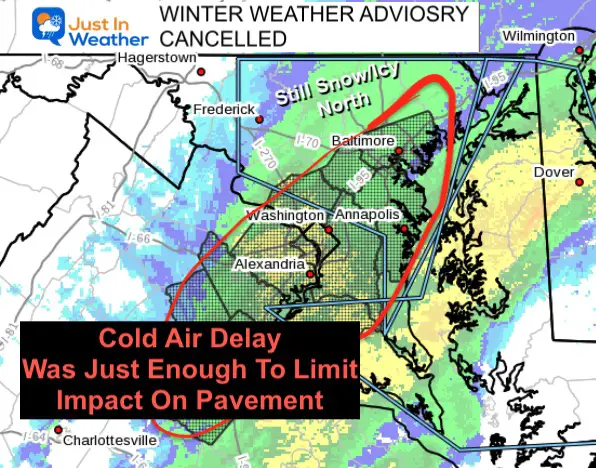
Due to the delay in timing, I may take the hit with lower snow totals. But this has always been more about the impact on the roads. As a result of the delay in cold air, The Winter Weather Advisory was dropped for metro areas… It is still in place for Northern Maryland (north and west of Baltimore) and Southern Pennsylvania.
Winter Weather Advisory CANCELLED!
The delay of the cold air was just enough to limit the impact for the roads.
This includes metro Baltimore, Washington, and Annapolis. Northern areas are still in the zone for icy travel.
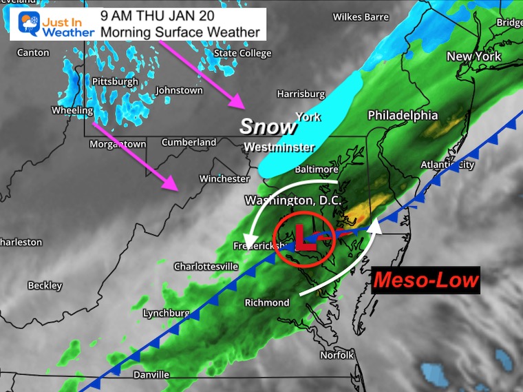
Weather Look from the top of the hour
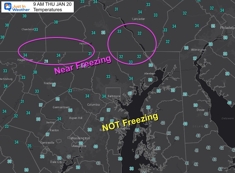
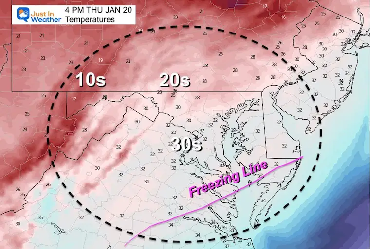
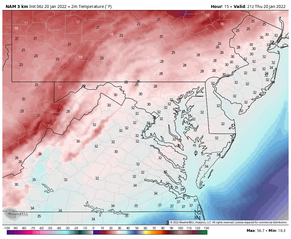
Temperatures at 9 AM
The cold air was delayed by an our or two..
Radar Snapshot
This product is NOT perfect. I have a report from Pete Welsh at The McDonogh School in Owings Mills: ‘Big Flakes were falling at 8:40 AM
If you get into the BIG FLAKE Zone, it still may overtake the warm pavement before temps drop cold enough.
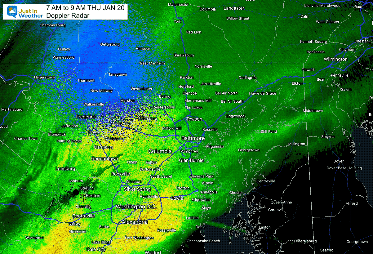
Radar Loop
Mesoscale Analysis
The cold front is moving through Maryland, while Low Pressure to the south is responsible for sending that heavy rain into Washington and Baltimore.
That meso-Low surged in moisture and is the main reason for slowing the front…
Burst Of Snow:
There may be more falling south of Baltimore mid day and into the afternoon…
However, the impact will be based on:
Where is the Freezing Line
How heave are snowfall rates to overtake the warmer pavement.
My Call For Snowfall
Zone breakdown below:
I will write up any acknowledge of the BUST zones after this ends.
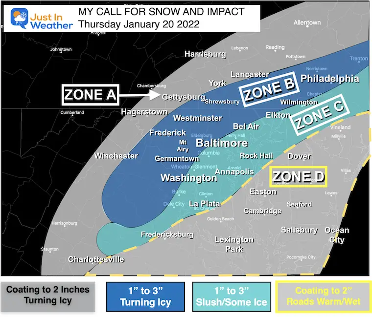
Zone A:
- Freezing line arrives earlier.
- Less snow but roads will turn icy before sunrise.
Zone B:
- Snow will fall before sunrise.
- Temps drop to freezing within 1 to 2 hours of change over, and expected to be icy through the morning commute.
Zone C:
- Transition to snow during the morning commute 7 to 9 AM.
- Temp near freezing, but marginal.
- Slushy roads. Some colder spot turn icy, especially farther inland.
- Places by the water (Havre de Grace, Sparrows Point, Cape St. Claire) less likely to have road impact due to slightly warmer temps.
Zone D:
- It will snow late morning and afternoon.
- Temps likely to stay above freezing, so most snow stickage will be on the grass.
- Some roads may get slushy, but most should remain wet.
Re-Freeze
Temp should still drop to Freezing later. Any surface still wet after 4 PM will have a chance to freeze into the evening. I suggest salting!
Temperature Animation
4 PM Thu to 7 AM Fri
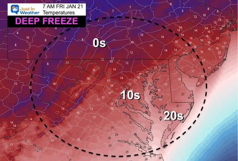
Friday Morning: Deep Freeze!
Yes! It will be that cold tomorrow morning, and this is not including the wind.
Looking Ahead
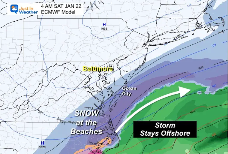
Coastal Storm Early Saturday Morning?
I have not put too much emphasis on this event for two reasons:
- I want to deal with the snow tomorrow morning first.
- Models have been inconsistent, and historically flip with coastal in the 3 to 5 day range.
I had suggested this may bump back a little west.. but the closest it looks to be is extreme Lower Eastern Shore. A few inches are possible at the beaches Saturday morning.
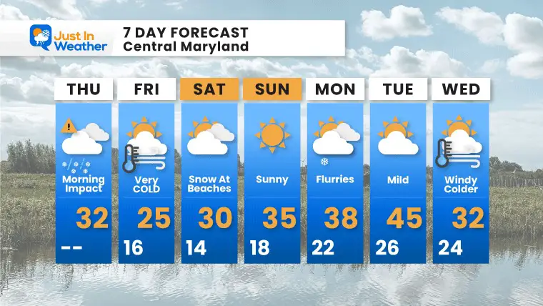
7 Day Forecast
ALSO SEE
ALL FITF GEAR

FITF THUNDERSNOW


Winter Outlook Series:
My Call For Snowfall

Last Winter Recap: My Old Outlook And Your Grades Of My Storm Forecasts


Please share your thoughts, best weather pics/video, or just keep in touch via social media


