


May 11 Aurora Viewing Forecast Weather And More Photos
Saturday May 11, 2024 The display of Northern Lights last night was historic. As the name implies, this is more common in the Northern Latitudes. On rare occasions we can…
Tuesday January 4 2022 – Afternoon Update
It’s been less than a day since our recent storm and some areas are still cleaning up. In fact many areas that were hit are not use to the 8 to 14 inches of snow and may be cleaning up for a couple of days.
Setting The Stage For More Snow:
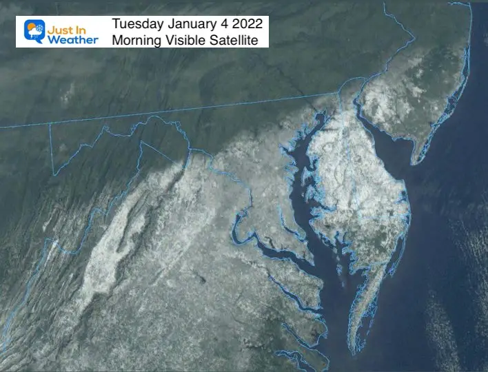
Snow On Satellite
The morning visible satellite had the assistance of a clear sky to help show the region impacted by snow. Deep snowpack, considered 6 inches to over 1 foot, is still covering the most of Virginia, the southern half of Maryland and most of Delmarva.
This will help refrigerate the atmosphere to feed into the next storm.
I have mentioned this many times over the years. In this case, I see that the atmosphere has laid down the tracks with a very strong event, and it will try to follow that path again.
“The trend is your friend”
I refer to the January 2000 winter I mentioned both on New Year’s Day and in my Winter Outlook. That as another La Niña winter with a very warm period around the New Year. Then the pattern turned and brought us 3 snow storms in 10 days between Jan 20 to 30. This exceeded the normal seasonal total, with a big snowstorm included.
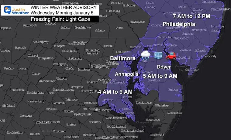
Winter Weather Advisory: Light Icing Wednesday Morning
These features are described with current observations on this winter page.
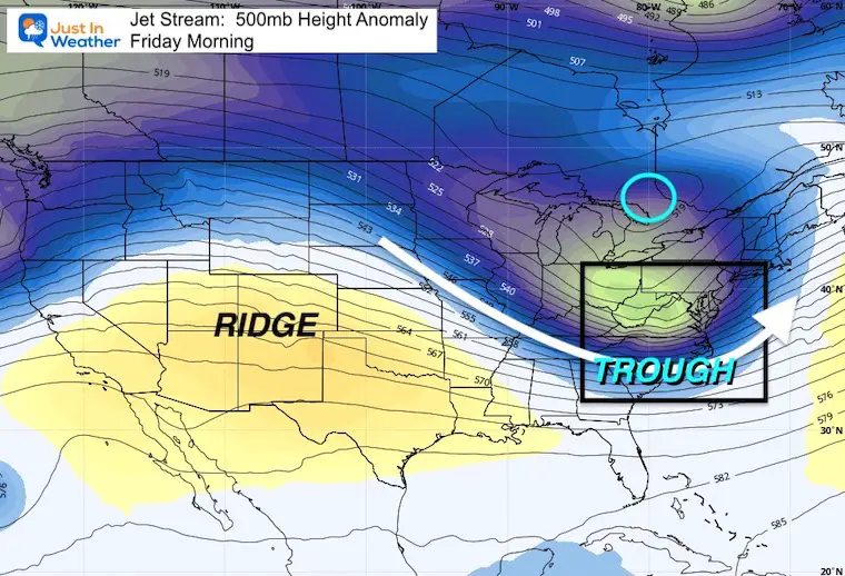
The pattern we need in winter for cold and stormy weather is a trough. This will establish itself again Thursday and Friday.
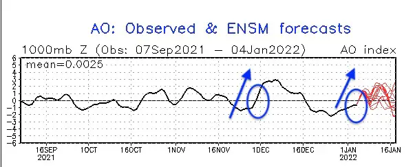
We have measured a -Negative Phase since the second half of December. That itself should benefit us. But it is not the only factor.
The forecast is trending to a Positive Phase over the next week. When there is a phase shift, that can support stormy weather for the Eastern US. We saw this transition after Thanksgiving… which did provide us with chilly weather and some region snow showers.
This is circulation across Southeast Asia. The main takeaway:
Regions 7, 8, and 1 are historically more favorable to feed a storm track to the west coast of the US. Sometimes coordinating for east coast storms as well.
The Observation is in Phase 7 and forecast to remain there for the next 2 weeks.

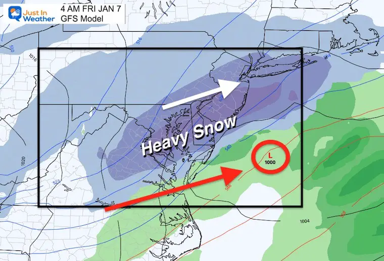
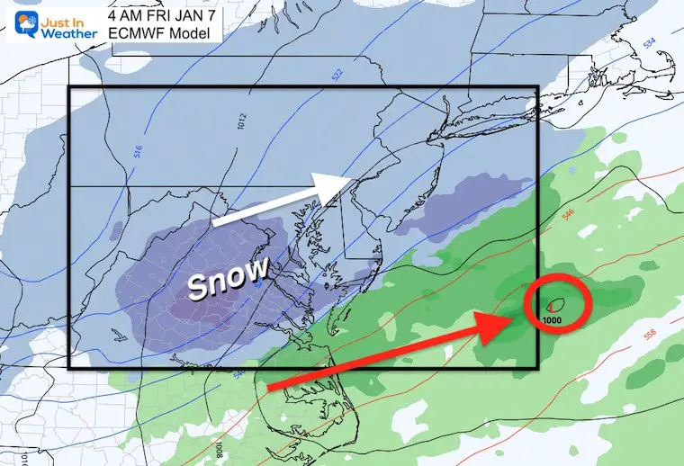
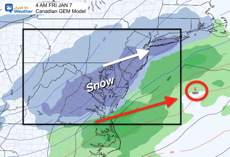
I am showing some live to our American Model because it actually performed well with the track of the last storm. In fact it was more consistent than the European Model.
Going the conditions I just mentioned, there is higher confidence that we will get another event.
This looks like a similar track to what we just had, just a little closer.
But, it is smaller, and quicker. The snow timing would be arriving before Midnight and ending around sunrise Friday.
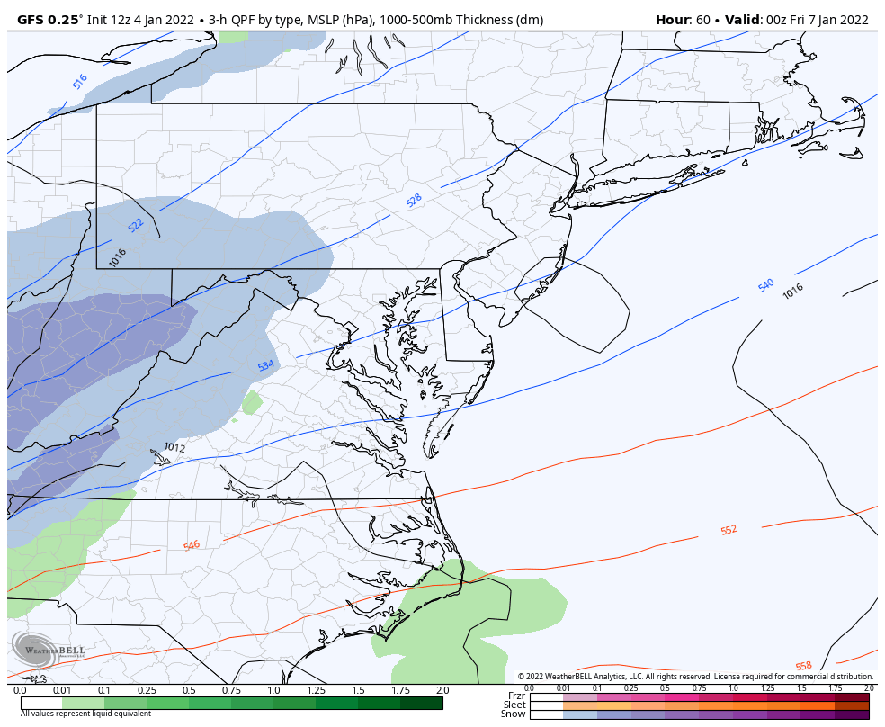
This model does show the heaviest band of snow over the same areas that just got hit. Still a spread of light snow farther north.
This solution does phase a little later, resulting in a later push of snow, with lower totals. Still a spread of light snow farther north.
This solution is the mid-range, highlighting the same areas that just got impact snow.
This looks like a cut off NW, but not a sharp cut off.
The confidence for snow is greater than 50%, even with a few days ahead.
Timing: Likely late Thursday night, ending Friday morning.
Snow Amounts: The models range between about 2 to 6 inches.
I DO NOT show snow maps on social media as I believe it feels hype and is misleading. I will share them within one of my reports on this site when I want to compare and contrast.
I WILL NOT show snow models yet. In fact I want to remind you of the recent event and all the high snow amounts on model maps. While there was some heave snow, Most of the models mentioned here tend to overdo snow until right before the event. That is one reason my forecast was lower and worked out.
I will begin that in my Wednesday updates.
Faith in the Flakes


Last Winter Recap: My Old Outlook And Your Grades Of My Storm Forecasts


