The first storm of the year, and the winter season turned out the be the biggest a lot of our region has seen in many years.
This ramped up in the prior two days, and continued to impressed with thunder snow, blizzard conditions, hundreds of thousands without power, and highest snow totals in normally warmer southern and eastern areas.
Baltimore’s BWI received 6.8” of snow For perspective:
New Record for the date. Old record was 1.6” in 1988
Largest since our record 29.2 inches in January of 2016
Almost matching our season total of 10.9” last winter.
More than 3 times the season total of 2020 (1.8”)
Now more than DOUBLE snowfall to date for season = 3.0”
*We are AHEAD of pace for snow this season!
Washington DC also had record snowfall for the date:
National = 6.7”
Dulles = 3.9”
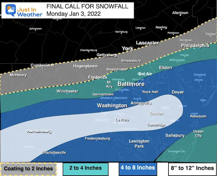
Below are regional maps AND lists of snow spotter reports. But first, I wanted to compare the regional snow map to my Final Call For Snowfall.
Then I ask you: Grade My Forecast.
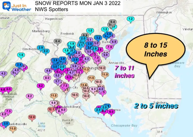
Regional Snow Map More local details and Delmarva map can be found below.
COMPARE TO
My Final Call For Snowfall
Notes:
The Good
Most of this forecast fit well, including my high snow zone.
I called less than the excessive model maps, but higher than The National Weather Service.
I know there were doubters, and even some of my clients kept asking this morning if it was going to happen. They were pleased.
The Bad:
My error was the north side. I knew there would be a sharp cutoff, but it was about 30 miles south of my forecast. Result: BUST for Frederick, Carroll, and Northern Baltimore to Harford Counties.
Grade My Forecast For Snow: Jan 3 2022
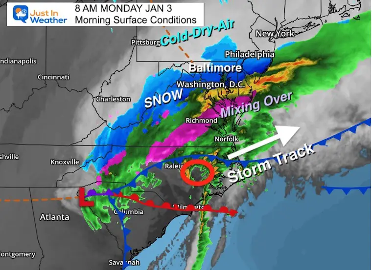
Storm Highlight Maps
Morning Surface Map
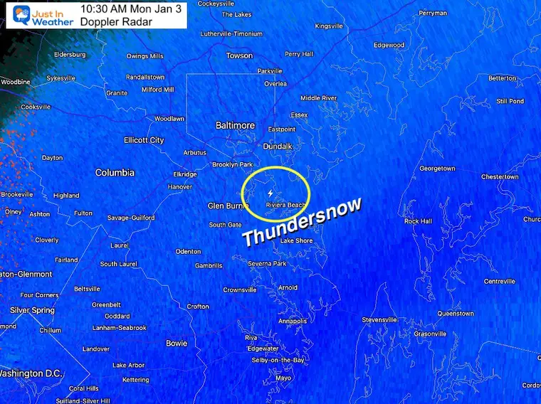
Thundersnow at 10:30 AM
NEW ITEM: FITF THUNDERSNOW SHIRTS
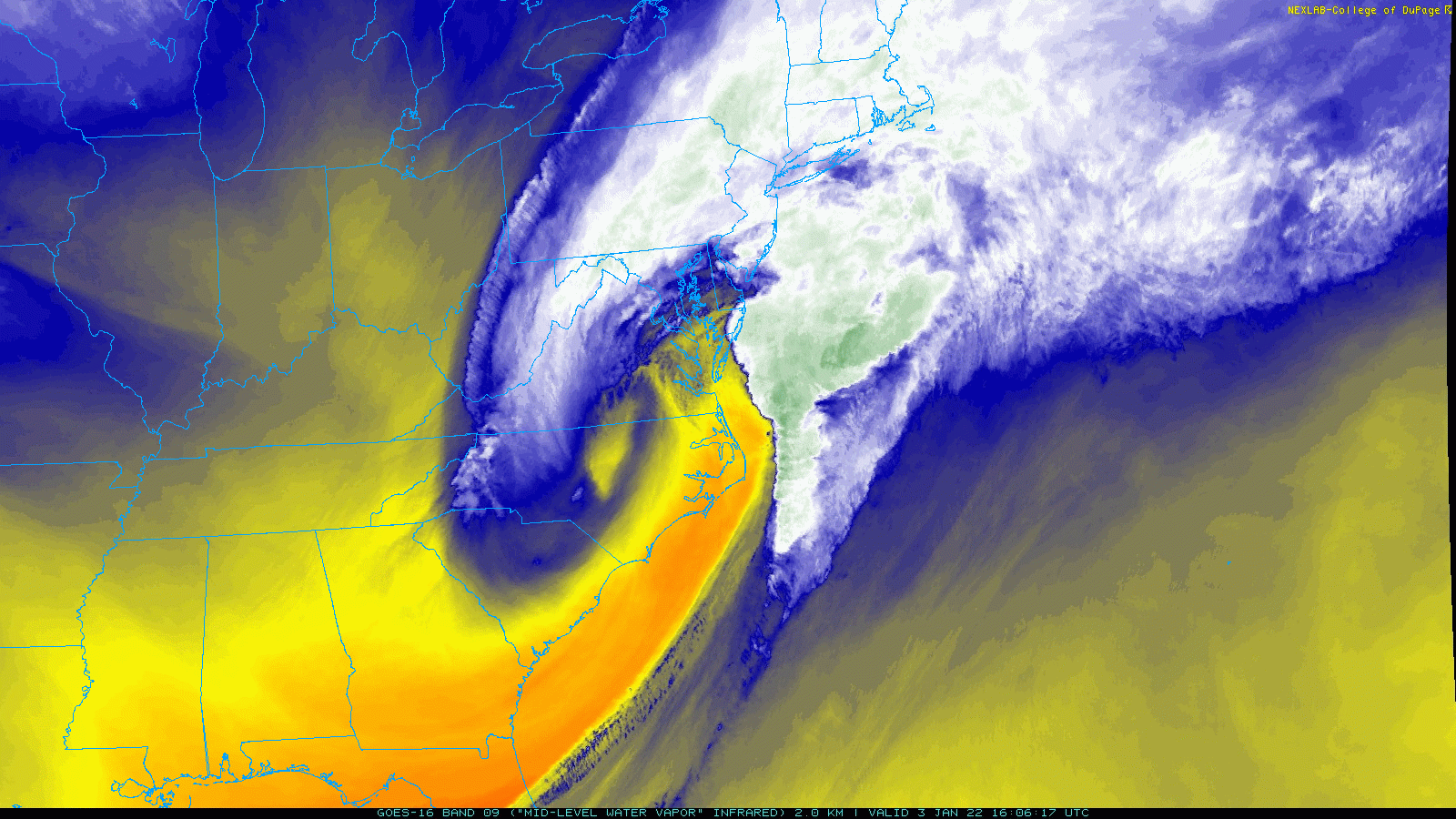
Water Vapor Satellite Loop
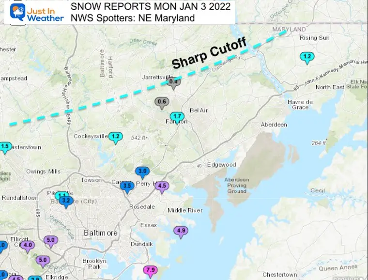
Local Maps And Snow Total Lists Northeastern Maryland: Cecil, Harford, and Baltimore Counties: Here we see that sharp cutoff!
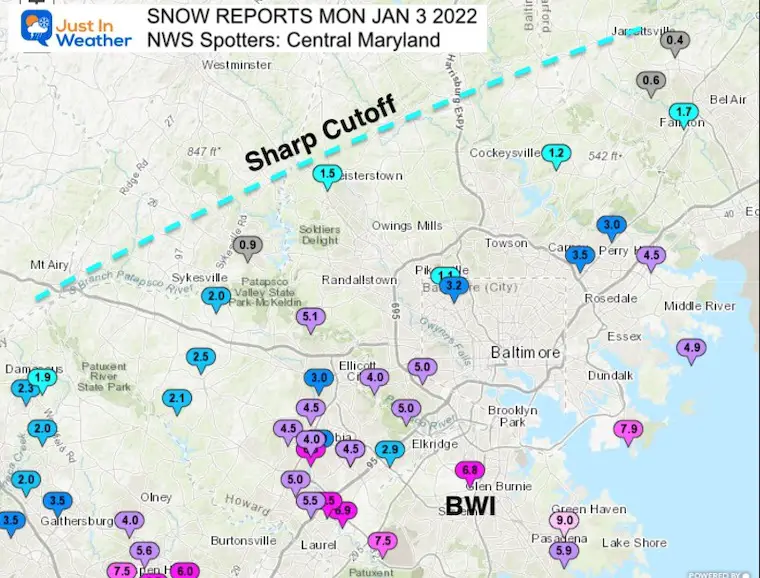
Central Maryland Notice the spread across Baltimore from north to south!
Here we see that sharp cutoff in the region that normally gets more snow NorthWest Baltimore and Carroll County.
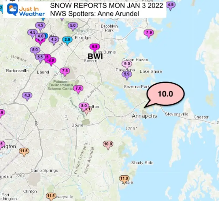
Anne Arundel County Big winner from Annapolis and southward.
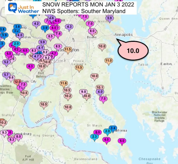
Southern Maryland
Anther Big Winner
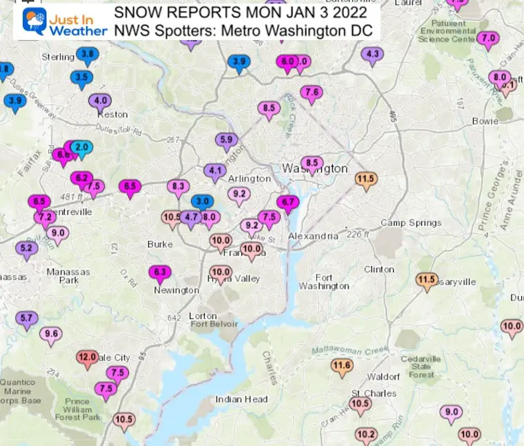
Metro Washington
Another Big Winner
Western Suburbs
This is where we can see the edge of the heavy snow.
Here we see that sharp cutoff just before Frederick and Mt. Airy- also areas that usually get more snow.
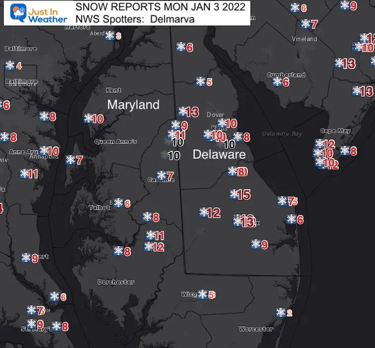
Delmarva
There were some very big totals in interior sections, with a few places in Delaware over 1 Foot!
Snow did finally stick at the beaches later in the day.
Snow Spotter List From the NWS Baltimore/Washington Office
********************STORM TOTAL SNOWFALL********************
LOCATION TOTAL TIME/DATE COMMENTS
SNOWFALL MEASURED
(inches)
DISTRICT OF COLUMBIA
…District of Columbia…
Washington 1 E 8.5 100 PM 1/03 Trained Spotter
Anacostia SSE 8.0 530 PM 1/03 Trained Spotter
National Zoo 1 WSW 6.6 140 PM 1/03 Trained Spotter
MARYLAND
…Anne Arundel County…
Churchton ENE 12.5 200 PM 1/03 Trained Spotter
Birdsville 11.0 233 PM 1/03 NWS Employee
Odenton 10.8 130 PM 1/03 Trained Spotter
Crofton 1 SSE 10.1 108 PM 1/03 NWS Employee
Londontowne 3 SW 10.0 1200 PM 1/03 CoCoRaHS
Green Haven 1 ESE 9.8 100 PM 1/03 Trained Spotter
Annapolis 2 NNE 9.5 514 PM 1/03 Trained Spotter
Odenton 1 WNW 8.3 245 PM 1/03 Trained Spotter
Crofton 2 NNE 8.0 100 PM 1/03 NWS Employee
Fort Meade 1 W 7.5 104 PM 1/03 Trained Spotter
Fort Smallwood State 7.5 300 PM 1/03 Trained Spotter
Odenton 1 S 7.2 130 PM 1/03 Trained Spotter
Bwi Airport 6.8 100 PM 1/03 Airport
Chelsea Beach 6.8 200 PM 1/03 Trained Spotter
…Baltimore County…
Edgemere ESE 7.9 1251 PM 1/03 Trained Spotter
Catonsville 1 SSE 5.0 100 PM 1/03 Trained Spotter
Middle River WSW 4.9 120 PM 1/03 Trained Spotter
White Marsh 2 E 4.5 1200 PM 1/03 Trained Spotter
Pimlico 1 NW 3.8 240 PM 1/03 Trained Spotter
Fullerton 1 N 3.5 1230 PM 1/03 Trained Spotter
Perry Hall 1 NNE 3.0 130 PM 1/03 Trained Spotter
Glyndon 1 SW 1.5 157 PM 1/03 Trained Spotter
Long Green 2 NW 1.2 1215 PM 1/03 Trained Spotter
…Baltimore City…
Catonsville 2 NE 5.0 138 PM 1/03 Trained Spotter
Pimlico SE 3.2 1215 PM 1/03 Trained Spotter
…Calvert County…
Huntingtown SW 15.5 215 PM 1/03 Trained Spotter
Dunkirk 2 SSW 13.0 140 PM 1/03 Trained Spotter
Prince Frederick 1 S 9.3 300 PM 1/03 Trained Spotter
Dowell 2 NE 5.5 350 PM 1/03 Trained Spotter
…Cecil County…
Woodlawn 2 ENE 1.2 108 PM 1/03 Trained Spotter
Fair Hill 1 SW 0.9 528 PM 1/03 Trained Spotter
…Charles County…
Waldorf 2 W 13.5 115 PM 1/03 Trained Spotter
Welcome 2 WNW 10.5 1214 PM 1/03 Trained Spotter
La Plata 3 ENE 10.2 1133 AM 1/03 Trained Spotter
Dentsville 1 SW 10.0 125 PM 1/03 Trained Spotter
Hughesville 2 ENE 10.0 1215 PM 1/03 Trained Spotter
…Frederick County…
Buckeystown 3 SW 0.4 1100 AM 1/03 NWS Employee
Adamstown 1 ESE 0.1 1200 PM 1/03 NWS Employee
…Harford County…
Aberdeen Proving Gro 2.5 350 PM 1/03 Trained Spotter
Bel Air 2 W 1.7 130 PM 1/03 Trained Spotter
Forest Hill 3 SW 0.8 140 PM 1/03 Trained Spotter
Forest Hill 1 NNW 0.4 100 PM 1/03 Trained Spotter
…Howard County…
Savage 1 ESE 6.9 115 PM 1/03 Trained Spotter
Columbia 6.5 1200 PM 1/03 Trained Spotter
Savage 1 N 6.5 1230 PM 1/03 Trained Spotter
Elkridge 2 W 6.3 1245 PM 1/03 Trained Spotter
Elkridge NW 6.2 300 PM 1/03 Trained Spotter
Columbia 2 NE 6.0 200 PM 1/03 Trained Spotter
Laurel 2 N 6.0 100 PM 1/03 Trained Spotter
Elkridge 2 WSW 5.9 145 PM 1/03 Trained Spotter
Elkridge 3 W 5.7 100 PM 1/03 Broadcast Media
Elkridge 5.6 147 PM 1/03 NWS Employee
Granite 1 SSE 5.1 1202 PM 1/03 Trained Spotter
Savage 1 WSW 5.0 100 PM 1/03 Trained Spotter
Simpsonville 1 SSE 5.0 1215 PM 1/03 Trained Spotter
Simpsonville 1 W 5.0 100 PM 1/03 Trained Spotter
Columbia 2 N 4.5 1256 PM 1/03 Trained Spotter
Oella 1 NW 4.5 1200 PM 1/03 Trained Spotter
Columbia 2 NW 4.5 1230 PM 1/03 Trained Spotter
Columbia 1 NE 4.0 106 PM 1/03 Trained Spotter
Ellicott City 1 SW 3.5 230 PM 1/03 Trained Spotter
Columbia 1 ENE 3.0 120 PM 1/03 Trained Spotter
Ellicott City 3.0 1250 PM 1/03 Broadcast Media
Glenelg 2 N 2.5 130 PM 1/03 Trained Spotter
Roxbury Mills 2 ESE 2.1 1215 PM 1/03 Trained Spotter
Sykesville 2 SSE 2.0 1100 AM 1/03 Trained Spotter
Sykesville 3 SE 1.5 1200 PM 1/03 CoCoRaHS
…Montgomery County…
Somerset 1 ENE 8.5 100 PM 1/03 Trained Spotter
Langley Park 1 W 7.6 1225 PM 1/03 Trained Spotter
Aspen Hill 1 SW 7.5 1220 PM 1/03 Trained Spotter
Four Corners 1 NNW 7.0 1245 PM 1/03 Trained Spotter
Glenmont 1 NNE 6.5 130 PM 1/03 Trained Spotter
Bethesda 1 WSW 6.0 200 PM 1/03 Trained Spotter
Spencerville WSW 6.0 210 PM 1/03 Trained Spotter
Four Corners 2 NW 6.0 100 PM 1/03 Trained Spotter
Colesville 6.0 1245 PM 1/03 Trained Spotter
Wheaton 1 ESE 6.0 100 PM 1/03 Trained Spotter
Chevy Chase 1 W 5.7 130 PM 1/03 Trained Spotter
Norbeck 1 ESE 5.6 1200 PM 1/03 Trained Spotter
Garrett Park 2 NW 5.0 542 PM 1/03 Trained Spotter
Potomac 2 N 4.2 100 PM 1/03 Trained Spotter
Olney 1 S 4.0 1200 PM 1/03 Trained Spotter
Garrett Park 1 WSW 3.9 1250 PM 1/03 Trained Spotter
Gaithersburg 1 SW 3.5 1222 PM 1/03 Trained Spotter
Washington Grove 1 N 3.5 1149 AM 1/03 Trained Spotter
Poolesville NE 2.0 100 PM 1/03 Trained Spotter
Damascus 1 SE 1.9 1210 PM 1/03 Trained Spotter
Germantown 2 WSW 1.8 1200 PM 1/03 Trained Spotter
…Prince Georges County…
Marlton 1 WSW 14.0 400 PM 1/03 Trained Spotter
Capitol Heights 11.5 100 PM 1/03 Trained Spotter
Cheverly S 9.5 135 PM 1/03 Trained Spotter
Savage 1 WNW 5.5 1240 PM 1/03 Trained Spotter
College Park 1 ENE 4.8 500 PM 1/03 Trained Spotter
Beltsville 1 E 4.3 1145 AM 1/03 Trained Spotter
…St. Marys County…
Callaway 2 W 8.7 251 PM 1/03 Trained Spotter
Park Hall 1 NNE 7.5 330 PM 1/03 Trained Spotter
Hollywood 3 S 6.5 330 PM 1/03 Trained Spotter
Leonardtown SSE 6.0 1230 PM 1/03 Trained Spotter
California 3 W 4.8 600 PM 1/03 Trained Spotter
Town Creek 1 W 3.4 125 PM 1/03 Trained Spotter
VIRGINIA
…Albemarle County…
Keswick 3 SSE 11.0 100 PM 1/03 Trained Spotter
Charlottesville 3 NN 9.0 1215 PM 1/03 Broadcast Media
Earlysville 3 NW 8.0 1200 PM 1/03 Trained Spotter
…Arlington County…
Baileys Crossroads 1 9.2 110 PM 1/03 Trained Spotter
Reagan National Apt 6.9 700 PM 1/03 Airport
Rosslyn 1 WSW 6.5 330 PM 1/03 Trained Spotter
…Augusta County…
Fishersville 1 NE 9.0 1020 AM 1/03 Trained Spotter
Waynesboro 1 S 9.0 1020 AM 1/03 Trained Spotter
Weyers Cave 1 SSW 7.8 1110 AM 1/03 Trained Spotter
Staunton 2 N 7.0 1100 AM 1/03 Trained Spotter
…City of Alexandria…
Alexandria 1 S 10.7 130 PM 1/03 CoCoRaHS
Lincolnia 2 S 10.0 1245 PM 1/03 Trained Spotter
Alexandria 2 W 9.7 117 PM 1/03 CoCoRaHS
Alexandria 1 W 9.2 1230 PM 1/03 Trained Spotter
Alexandria 1 ENE 7.5 1200 PM 1/03 Trained Spotter
…City of Charlottesville…
Newcomb Hall 1 SW 7.0 1120 AM 1/03 Trained Spotter
…City of Falls Church…
Lake Barcroft 1 W 10.0 200 PM 1/03 Trained Spotter
…City of Fredericksburg.. .
Fredericksburg 1 SSW 14.1 145 PM 1/03 Trained Spotter
Dunavant 2 SE 14.0 230 PM 1/03 Trained Spotter
…City of Harrisonburg…
Harrisonburg 2 W 6.5 1230 PM 1/03 Broadcast Media
…City of Waynesboro…
Waynesboro 1 SSW 5.2 1235 PM 1/03 Trained Spotter
…Culpeper County…
Culpeper 1 W 8.2 1200 PM 1/03 Trained Spotter
…Fairfax County …
Franconia 1 SSE 11.8 200 PM 1/03 CoCoRaHS
Annandale 1 WSW 10.5 1200 PM 1/03 Trained Spotter
Rose Hill ENE 10.0 100 PM 1/03 Trained Spotter
Franconia 1 SSW 10.0 115 PM 1/03 Trained Spotter
Dunn Loring 1 SSE 8.3 100 PM 1/03 Trained Spotter
Fairfax Station 1 SE 8.2 445 PM 1/03 Trained Spotter
Chantilly 3 SE 8.1 155 PM 1/03 Trained Spotter
Lincolnia 1 WNW 8.0 1245 PM 1/03 Trained Spotter
Chantilly 2 ENE 7.9 130 PM 1/03 Trained Spotter
Centreville 1 S 7.2 1240 PM 1/03 Trained Spotter
Chantilly 3 E 7.1 1235 PM 1/03 Trained Spotter
Vienna 1 WNW 7.0 133 PM 1/03 Trained Spotter
Chantilly 3 N 6.6 115 PM 1/03 NWS Employee
Fairfax 1 N 6.5 112 PM 1/03 NWS Employee
Centreville W 6.5 1215 PM 1/03 Trained Spotter
Langley 1 SE 6.4 130 PM 1/03 Trained Spotter
Herndon 1 NNE 5.9 100 PM 1/03 NWS Employee
Reston 3 SW 5.0 1146 AM 1/03 Trained Spotter
Reston 2 N 4.9 1222 PM 1/03 Trained Spotter
Herndon 2 ENE 4.5 100 PM 1/03 Trained Spotter
Sterling Park 2 ENE 3.5 1223 PM 1/03 Trained Spotter
…Fauquier County…
Greenwich 1 W 8.0 1200 PM 1/03 Trained Spotter
Opal 7.5 327 PM 1/03 NWS Employee
…Frederick County…
Stephens City 2 E 1.6 930 AM 1/03 Trained Spotter
...Greene County…
Quinque 2 WSW 7.8 145 PM 1/03 Trained Spotter
…King George County…
King George 1 NE 12.5 500 PM 1/03 Trained Spotter
…Highland County…
Monterey 4.3 1100 AM 1/03 911 Call Center
Hightown 3 NW 4.1 1015 AM 1/03 Trained Spotter
Hightown 5 NW 3.8 1000 AM 1/03 Trained Spotter
…Loudoun County…
Arcola 3 S 6.2 1130 AM 1/03 Trained Spotter
Arcola 2 SSE 4.5 155 PM 1/03 NWS Employee
Arcola 1 NNE 4.0 1000 AM 1/03 Trained Spotter
Ashburn N 4.0 1200 PM 1/03 Trained Spotter
Ashburn 3 WSW 4.0 945 AM 1/03 NWS Employee
Dulles International 3.9 100 PM 1/03 Airport
Ashburn 2 SW 3.8 1100 AM 1/03 NWS Employee
Countryside 2 ESE 3.8 1100 AM 1/03 Trained Spotter
Purcellville 2 NNE 2.2 1202 PM 1/03 Trained Spotter
Hillsboro 3 NW 2.0 300 PM 1/03 Trained Spotter
…Nelson County…
Elma 2 SW 4.8 1215 PM 1/03 Trained Spotter
…Orange County…
Lahore 2 NW 14.0 130 PM 1/03 Trained Spotter
Thornhill 12.0 1244 PM 1/03 Trained Spotter
…Page County…
Honeyville 1 ESE 6.8 1030 AM 1/03 Trained Spotter
Ida 1 SW 6.0 1200 PM 1/03 Trained Spotter
…Prince William County…
Dale City 1 W 12.0 105 PM 1/03 Trained Spotter
Dumfries 1 ENE 12.0 119 PM 1/03 Trained Spotter
Manassas 1 ENE 10.5 100 PM 1/03 Trained Spotter
Independent Hill 3 N 10.2 145 PM 1/03 Trained Spotter
Montclair 1 NE 9.0 140 PM 1/03 Trained Spotter
Gainesville 2 S 6.8 245 PM 1/03 Trained Spotter
Manassas 3 SSE 5.7 1245 PM 1/03 Trained Spotter
Manassas Park 1 NNW 5.2 1015 AM 1/03 Trained Spotter
Woolsey 1 SW 4.8 1105 AM 1/03 Trained Spotter
…Rockingham County…
Massanutten 1 SE 8.0 1245 PM 1/03 Trained Spotter
Timberville 3 NW 5.0 930 AM 1/03 Trained Spotter
…Spotsylvania County…
Chancellorsville 4 E 14.5 1238 PM 1/03 Trained Spotter
Massaponax 3 NE 14.0 110 PM 1/03 Trained Spotter
Chancellorsville 3 S 12.1 1214 PM 1/03 Trained Spotter
White Oak 5 SSW 12.1 1234 PM 1/03 Trained Spotter
White Oak 4 SSW 10.8 116 PM 1/03 Trained Spotter
…Stafford County…
Glendie 2 SSE 14.6 140 PM 1/03 Trained Spotter
Holly Corner 1 ENE 14.5 115 PM 1/03 NWS Employee
Brookfield 1 ENE 12.0 312 PM 1/03 Trained Spotter
Roseville 2 WNW 11.5 125 PM 1/03 Trained Spotter
Aquia 2 SE 11.5 100 PM 1/03 Trained Spotter
…Warren County.. .
Linden 3 W 6.0 1042 AM 1/03 Trained Spotter
Bentonville 5.5 1000 AM 1/03 Trained Spotter
Front Royal 1 ENE 4.0 1115 AM 1/03 Trained Spotter
Riverton 1 WNW 3.4 1045 AM 1/03 Trained Spotter
WEST VIRGINIA
…Jefferson County…
Bloomery 3 SSE 2.9 1050 AM 1/03 Trained Spotter
ALSO SEE
Winter Outlook Series: My Call For Snowfall
Last Winter Recap: My Old Outlook And Your Grades Of My Storm Forecasts
Please share your thoughts, best weather pics/video, or just keep in touch via social media