Conditions: Baltimore, Maryland, 05/20/2024 11:50:03 pm
Temperature

62°

Mostly Clear

60°

Dew Point
Relative Humidity

93%

Feels Like

62°

Wind (N)

0mph

Air Pressure

30.01

Sun
Sun Rise

05:48 AM

Sun Set

08:17 PM

Day Length

14:29 Hours

Difference

1 min 37 sec gain

Moon
Moon Rise

05:41 PM

Moon Set

04:04 AM

Next: Full Moon

May 23,2024

Moon Phase

Waxing Gibbous

Climate
Average Low

53°

75°

Average High
Record Low

39°


(2002)

95°


(1962)
Record High
Conditions

Saturday Evening Wind And Storm Line Update

Severe Weather
Forecast
Warnings

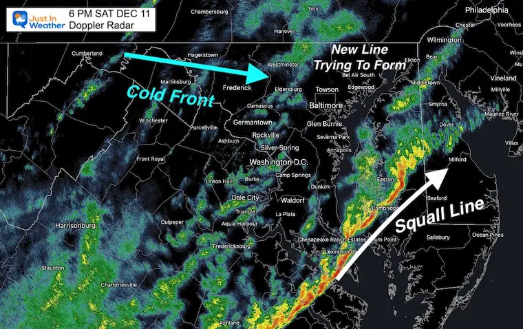
Saturday December 11 at 6 PM

I have received a lot of messages today form people with storm anxiety. After the devastating images from last night’s deadly tornadoes, I understand the concern for our region today.

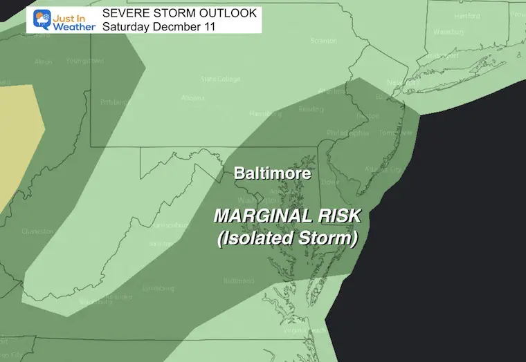
Yes, this cold front is from that same storm system, but it there is less energy available now. We have strong winds, and some squall lines with the small chance to turn severe.

In the post, I have the latest timelines for wind, rain, and even a live widget to track the radar.

Evening Surface Weather

Reminder, you can see the local current conditions in the Currents Tab on the right –>  Tap each tile for more info. See the top menu to change the location to another regional airport.


Satellite Loop

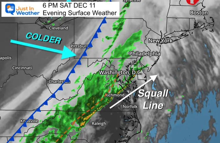
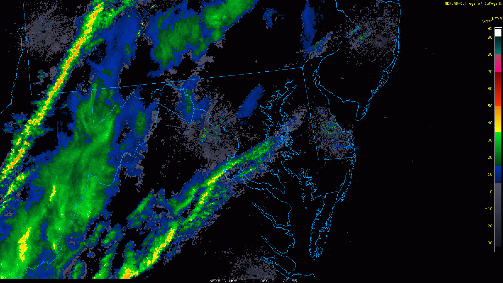
A very sharp back edge to this front highlights to contrast of air masses feeding energy into the system.


December-11-weather-storm-stellite


Storm Outlook Reminders

Severe Storm Potential

Marginal means only isolated cells may turn severe. The chance is 15% or less.


Wind Advisory 

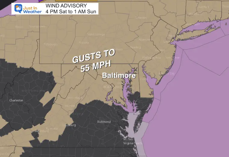
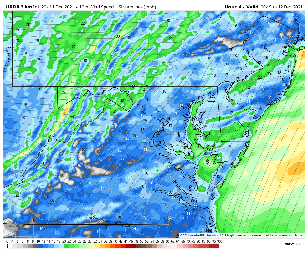
See the wind forecast below.


Radar Loop

4 PM to 6 PM

The line of storms developed well ahead of the cold front and pushed into southern Maryland this afternoon.

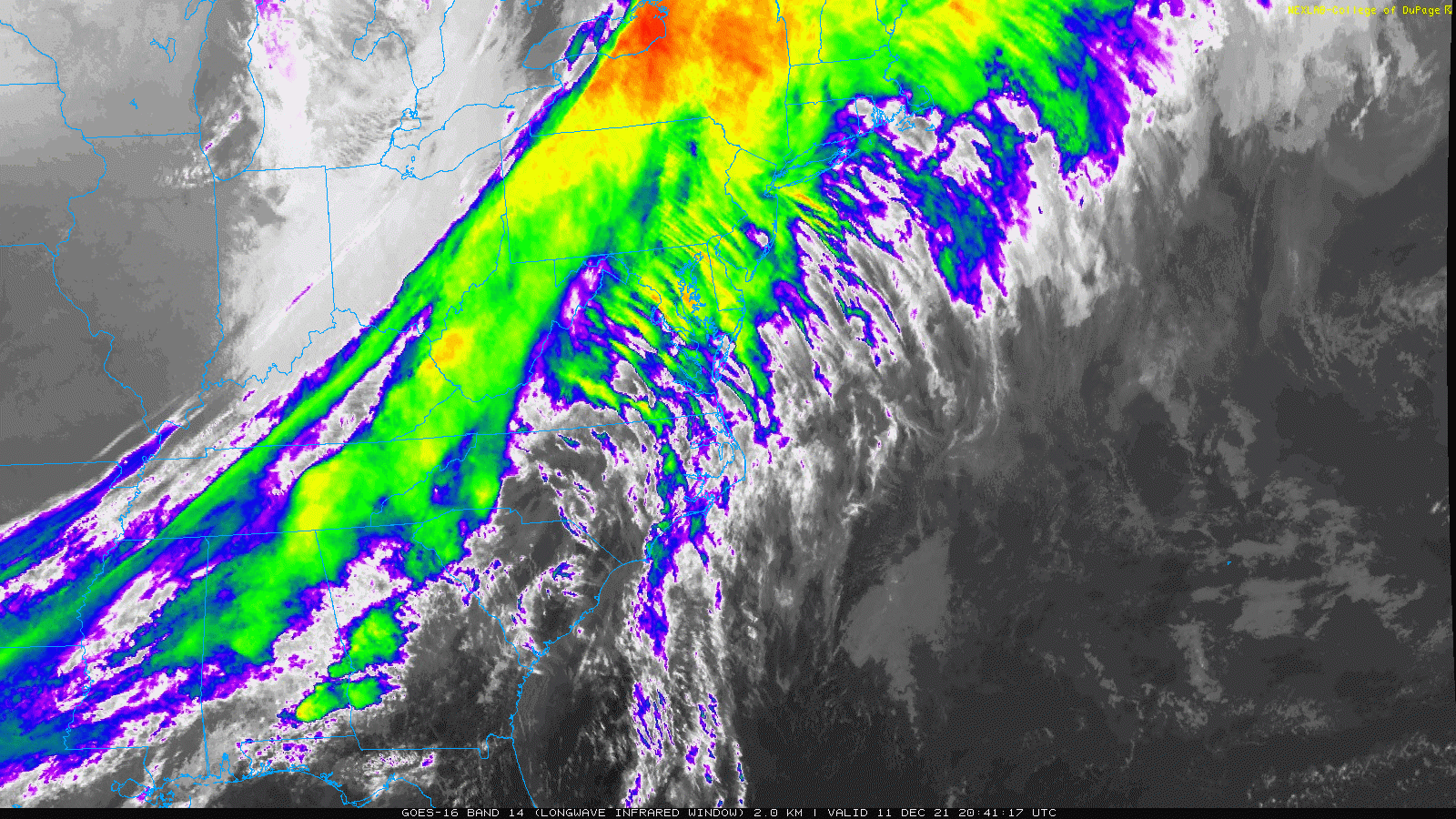
This highlighted the energy in the atmosphere and continued to validate the point that our high resolution models are not perfect, but helpful.

The western line seems to fade while crossing the mountains. This is expected to regenerate while passing central Maryland this evening.


December-11-weather-rain-storm-radar-satruday-evening


Doppler Radar Snapshot at 6 PM


Radar Simulation —-> slider

Staring at 6 PM

This high resolution model did miss some of the activity we are already seeing. There are two take aways to apply to this timeline:

  1. There may be more rain than shown here.
  2. The timing may be about 1 hour faster/earlier than shown here.
december-11-weather-rain-storm-saturday-pm-6
december-11-weather-rain-storm-saturday-pm-7
december-11-weather-rain-storm-saturday-pm-8
december-11-weather-rain-storm-saturday-pm-9
december-11-weather-rain-storm-saturday-pm-10
december-11-weather-rain-storm-saturday-pm-11
december-11-weather-rain-storm-sunday-am-12
december-11-weather-rain-storm-sunday-am-1
december-11-weather-rain-storm-sunday-am-2
previous arrow
next arrow


Live Radar Widget

Compare to the simulation above to how the timing is working out. 

See the wind and temperature forecast below. 


Wind Animation Through 7 AM

The winds will swing to the NorthWest behind the front. This may come with an initial surge of the strongest winds, then hold strong through midnight steady 20 to 30 mph. Some gusts may still reach to 50 mph.

December-11-weather-wind-forecast-update


Temperatures Through 7 AM


December-11-weather-temperature-forecast


Temperatures at 8 AM

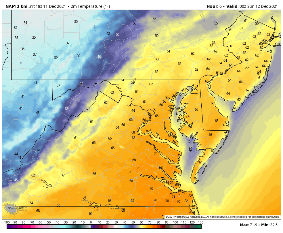
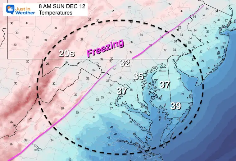
Lows should be in the 30 for most in central Maryland, with freezing conditions inland. 


Weather posts straight to your inbox

Sign up and be the first to know!


ALSO SEE

NOAA OUTLOOK: Warm Mid December, Please Let Me Explain


What is Faith in the Flakes: History of December 5th Snow


Winter Outlook Series:

My Call For Snowfall


Last Winter Recap: My Old Outlook And Your Grades Of My Storm Forecasts

Winter Weather Page – Lots of resources


Solar Cycle Increasing Sunspots Suggests More Snow


Comparing 4 Different Farmer’s Almanacs: Majority colder winter outlook than NOAA


NOAA Winter Outlook- But Read The Fine Print


Signals For Early Start To Winter In November


Winter Outlook Series: La Nina Double Dip


Nor’easters May Give Hint For Winter La Nina Pattern


Winter Folklore Checklist


Please share your thoughts, best weather pics/video, or just keep in touch via social media

Facebook: Justin Berk, Meteorologist

Twitter: @JustinWeather

Instagram: justinweather