Saturday October 30 2021
The storm that blew through on Friday had brought strong winds and the expected line of heavy rain during the afternoon and evening. But the hardest impact of that event has been and continues to be on the Chesapeake Bay and tributaries. A few spots have hit Record Flood Stage from Havre de Grace to Solomons Island. Other areas may have not reached their highest levels, but flooding ranged from Moderate to Major.
Flooding remains an issue this morning primarily because the high water is being held in place with winds from the south. They are not as strong, but limits the tide flowing out. Gradually that will improve.
This post is a focus on the Bay flooding and forecast water levels. I will have a full weather report to follow.
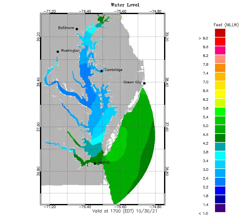
Water Levels: Observed and Forecast
Selected stations from North to South
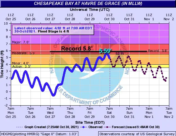
Havre de Grace – just .21 Ft below flood stage record at 5.8 Ft in Isabel.
Moderate Flood Stage: There has been damage on the promenade
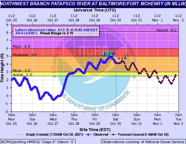
Baltimore at Fort McHenry – Observed + 4.92 Ft was thankfully below the forecast 5.5 to 6 Ft, and not the record of 8.12 Ft seen with Isabel. It was bad, but why I hesitated to correlate with that hurricane.
Moderate Flood Stage
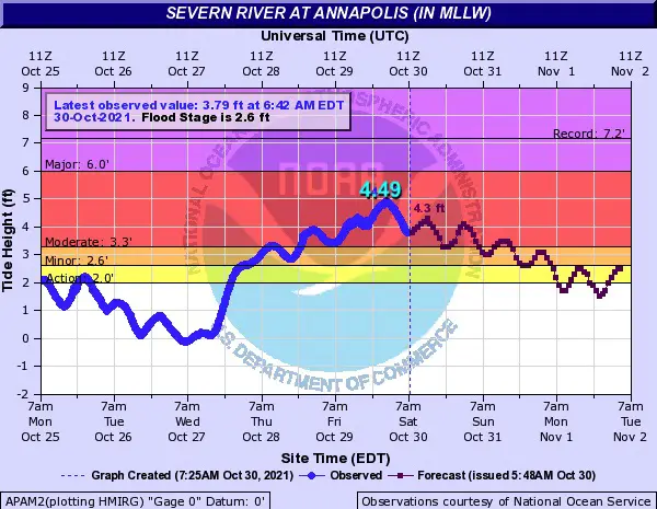
Annapolis- The Severn River reached 4.49 Ft, well below the record of 7.2 Ft.
Moderate Flood Stage
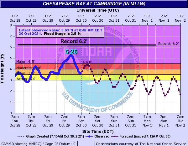
Cambridge – The Chesapeake Bay stayed 1 Ft below the record, but flooding did reach inland on Delmarva with some rivers to places like Salisbury.
Major Flood Stage
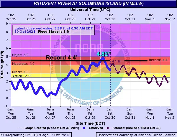
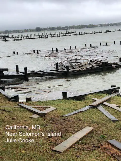
Solomons Island – The Patuxent River set a new record of 4.82 Ft earlier today.
Almost Major Flood Stage
This is where we saw the photo of docks being destroyed.
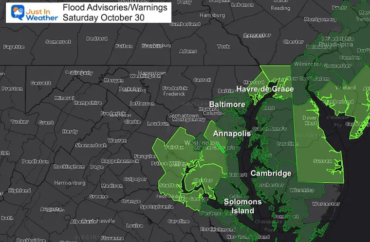
Coastal Flood Warnings and Advisories
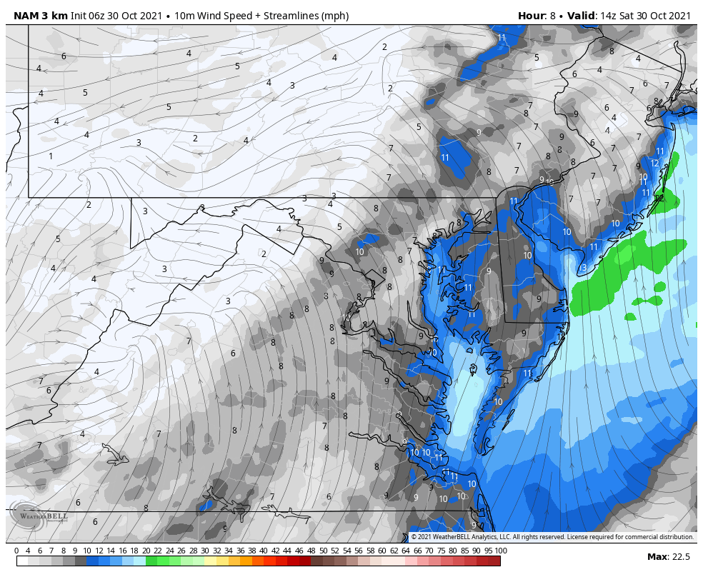
Wind Forecast
10 AM Saturday to 6 PM Sunday
Winds remain light, but from the South today. That will hold water levels high, but they will slowly recede. The winds will shift and help with improvement on Sunday. Here we see the wind flow forecast.
Water Level Forecast To Drop
Click the map for the animated forecast for water levels, and also see forecasts for winds, currents, water temps, and salinity.
Central Maryland Flooding
Here is a collection of flood video and photos from the afternoon.
You can search for many other spot forecasts here:
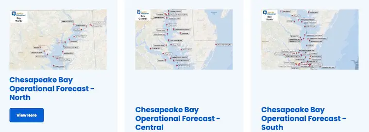
Operational Bay Forecasts
Click to see water forecast levels, winds, and tides for dozens of locations
High Tide and Low Tide Tables
West Side Chesapeake Bay
Havre de Grace
Saturday
- High 5:26 AM
- Low 1:03 PM
- High 5:59 PM
Bowley Bar, Middle River
Saturday
- High 3:04 AM
- Low 10:19 AM
- High 3:37 PM
- Low 9:27 PM
Baltimore, Fort McHenry
Saturday
- High 2:13 AM
- Low 9:36 AM
- High 2:46 PM
- Low 8:44 PM
Annapolis, US Naval Academy
Saturday
- High 12:43 AM
- Low 7:52 AM
- High 1:16 PM
- Low 7:00 PM
Chesapeake Beach
Friday
High 11:26 PM
Saturday
- Low 6:31 AM
- High 11:59 AM
- Low 5:39 PM
Solomons Island, Patuxent River
Friday
Saturday
- Low 4:50 AM
- High 10:08 AM
- Low 3:58 PM
- High 10:29 PM
East Side Chesapeake Bay
Charlestown, Northeast River
Saturday
- High 6:05 AM
- Low 1:39 PM
- High 6:38 PM
Metapeake, Kent Island
Saturday
- High 12:43 AM
- Low 7:47 AM
- High 1:16 PM
- Low 6:55 PM
Choptank River – Cambridge
Friday
Saturday
- Low 7:08 AM
- High 12:04 PM
- Low 6:16 PM
Wicomico Rivier, Salisbury
Friday
Saturday
- Low 5:11 AM
- High 11:14 AM
- Low 5:20 PM
- High 11:35 PM
Atlantic Coast
Ocean City Fishing Pier
Saturday
- High 3:14 AM
- Low 9:14 AM
- High 3:42 PM
- Low 10:06 PM
Search For More Tide Charts
Maryland Tide Tables
Also See The Winter Outlook Series:
Winter Folklore Checklist
NOAA Winter Outlook- But Read The Fine Print
Signals For Early Start To Winter In November
Winter Outlook Series: La Nina Double Dip
Nor’easters May Give Hint For Winter La Nina Pattern
Faith in the Flakes Gear

SNOWSTIX – Available Now

Please share your thoughts, best weather pics/video, or just keep in touch via social media


