March 6 2022
Sunday Evening Update
A couple of days ago I wrote a report also mentioning March Madness. Here we are just getting started and it’s about to get more weird. These are the times where the myths of fitting every season into a week grow from. We have one more potential record high tomorrow, followed by a line of thunderstorms, then followed by two chances to at least see snowflakes flying this week.
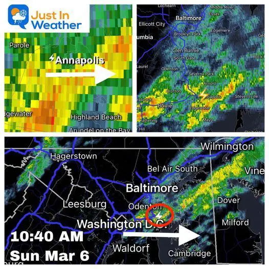
This morning we already had thunder in central Maryland. We may once again put the Winter Weather Folklore to the test: “If in winter there is thunder, snow will fall in one week or under”.
We may be in meteorological spring, but it’s still astronomical winter for two more weeks.
This is not the first time we have had 70s followed by snow. In fact, we just did it two weeks ago on February 23 to 24th. It’s definitely not the first time in March either. But it does sting when you might have written the season off and it keeps coming back like a stray cat.
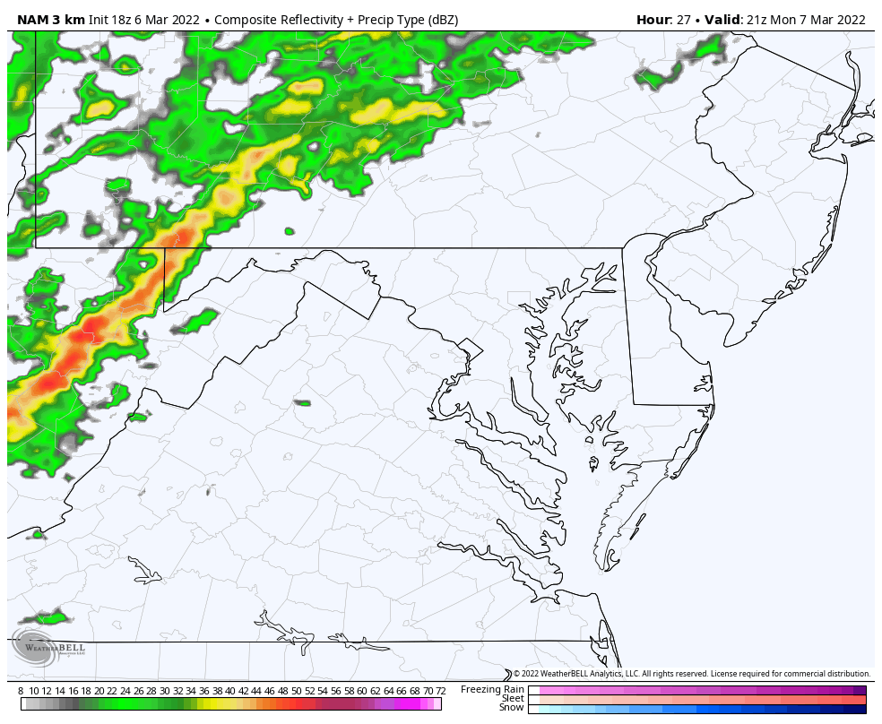
Morning Radar Recap
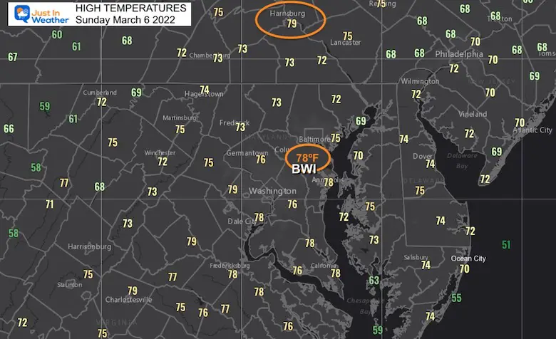
Sunday High Temperature Map
The highest reading in our region was in Harrisburg where it reached 79ºF. Washington was close behind at 78ºF, but that was not a record there.
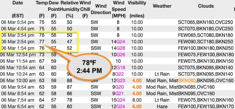
BWI Airport Hourly Observations
The high mark was set at 2:44 PM, so it occurred was between reports.
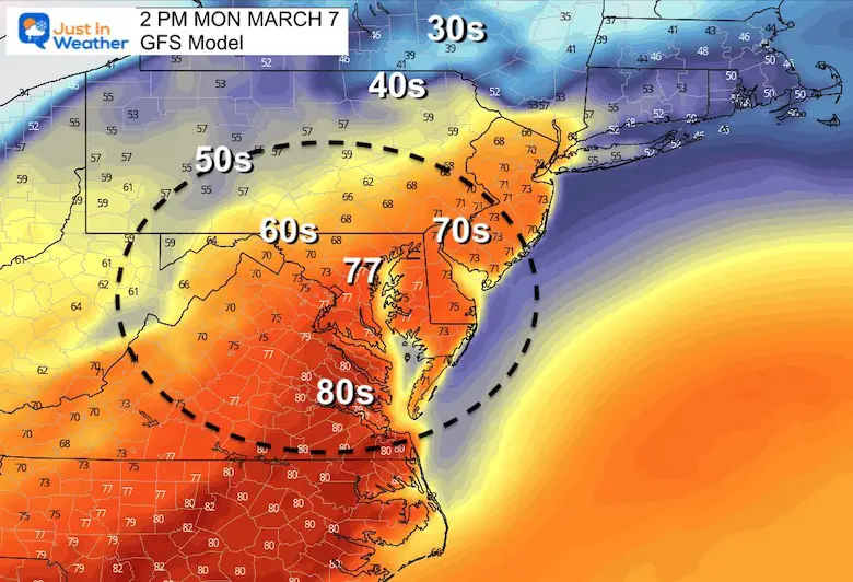
Ready To Do It Again Monday?
Forecast High Temperatures
The 77ºF forecast for BWI is enough to break the record of 76ºF set in 1974. Often we see record high temps on the books sun multiple days. But I suspect we may go higher. Much like today, we tend to end up warmer than model forecasts.
Perhaps the 80s will be closer to Central Maryland..?
Then the Cold Front
We will track a line of heavy rain, with some strong thunderstorms during the late afternoon entering the western Maryland Mountains. It should reach central areas
(Frederick, Westminster, York, Washington, Baltimore, Bel Air, and Annapolis )
Between 5 PM and 8 PM
Radar Simulation: 4 PM Mon to 12 AM Tue
Falling Temperatures
Animation Mon 3 PM to Tue 7 AM
From the upper 70s to 30s…

About The Snow
I need to emphasize that I am NOT calling for a big impact at this time. In fact the first of the two events may simply just be a mix of snow and sleet with rain.
Also: To get snow to have any chance to stick in March, we need it to begin overnight AND with high intensity. Otherwise both the warm ground and high sun angle defeat our chances for stickage.
So, this is more for ambience and proof of the cold pattern NOT being overhyped.
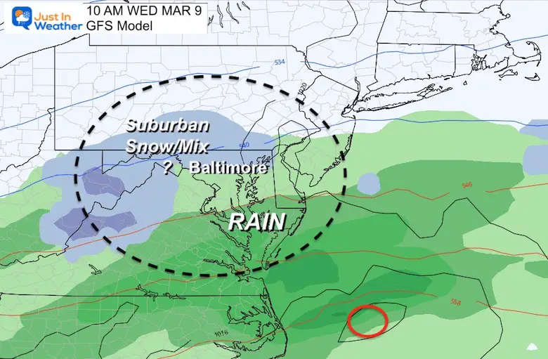
Wednesday Snow?
The GFS Model is more extensive than the European Model with the chance for snow… Both occur with temps above freezing at the surface. However it will be cold enough at cloud level to support ice crystal formation to fall (snow or sleet).
GFS Model
Surface temperatures will be in the upper 30s to lower 40s. So no stickage to talk of, but falling snow is possible.
However, there may be a coating in the high mountains over 2,500 Ft.
European ECMWF Model
This plot confines the snow (more realistically) in the higher terrain. However, there is the suggestion that snow and sleet may mix in the western and northern suburbs of Baltimore.

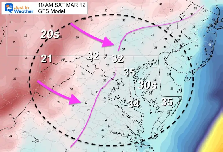
Saturday Morning
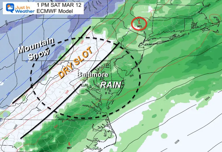
The GFS Model works out the Polar Front with perfect timing to phase and develop a coastal Low. You can compare to the European that does a similar thing but the timing is off and brings a dry slop east of the mountains.
This is definitely interesting and will be fun to watch all week. However, I do have plans that I don’t want to be affected. So personally, this time I am NOT rooting this on.
GFS Model at 10 AM

Temperature Snapshot at 10 AM
I know a lot of your weather apps are showing 40s for high temps. That may be closer to midnight, as we see temps falling during the morning and afternoon.
Here we see the freezing line trying to approach the western suburbs. It will be battling the higher sun angle, so IF that system develops it will be a challenge.
GFS Model Animation
Watch the phasing along that front early Saturday that moves on to a potent event for New England.

For Comparison….
European Model
This is more reasonable to have a dry slop east of the mountains. However I need to reinstate the fact that the GFS did outperform the the Euro a couple of times in January. So we can’t write this off yet.
Polar Vortex Disruption Follow Up
I wrote two reports recently with the Polar Vortex Disruption in the title. There have been a couple of people who wanted to challenge the term for being misleading on purpose.
I need to emphasize that they clearly do not know me or my intentions. I do not believe in click-bait.
It is a shame that the media has overplayed and sort of ruined well known meteorological terms such as Polar Vortex, Bomb Cyclone, and El Niño. They are real things that existed long before modern TV and social media.
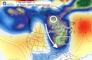

I do not want to shy away from legitimate terminology, but I only use them when they apply.
I have also been careful to use the cliche “Beware The Ides Of March” until we get closer to that time frame. When appropriate, I will use that title only once.
As for the weather terms, there are many more very catchy ones in the arsenal. Perhaps when the weather gets quite, I will share a larger list with you.
Also See:
Can it snow in March? Yes! Can it stick though?
Yes! However, we would need something special for it to be a legit impactful storm. Most of the time in March, we need an event to begin or mostly fall at night to allow stickage. Then again, March 12 to 14 in 1993 was the famed SuperStorm event that produced about a foot of snow with heavy icing on Baltimore, and three feet of snow inland.
Anything is possible… Especially with a high amplitude pattern like this.
So, no promises, but if you have Faith in the Flakes it will be an interesting week or two to watch.
ALSO SEE
ALL FITF GEAR

FITF THUNDERSNOW


Winter Outlook Series:
My Call For Snowfall

Last Winter Recap: My Old Outlook And Your Grades Of My Storm Forecasts


Please share your thoughts, best weather pics/video, or just keep in touch via social media
*Disclaimer due to frequent questions:
I am aware there are some spelling and grammar typos. I have made a few public statements over the years, but if you are new here you may have missed it:
I have dyslexia, and found out at my second year at Cornell. I didn’t stop me from getting my meteorology degree, and being first to get the AMS CBM in the Baltimore/Washington region.
I do miss my mistakes in my own proofreading. The autocorrect spell check on my computer sometimes does an injustice to make it worse.
All of the maps and information are accurate. The ‘wordy’ stuff can get sticky.
There is no editor that can check my work when I need it and have it ready to send out in a newsworthy timeline.
I accept this and perhaps proves what you read is really from me…
It’s part of my charm.
#FITF


