Friday January 28 2022
Noon Update
This is the trend many were writing me about. I held the window open for my First Call For Snowfall to be increased. If you have read my updates or saw elsewhere, new data has supported this major winter storm to track closer to the coast. That little shift makes a big difference for our region on the edge of it.
In my last report I showed the Blizzard Warning EXPANDED to Salisbury, Lower Eastern Shore of MD and Sussex County in Delaware. Now (as expected) The National Weather Service has expanded the Winter Weather Advisory farther west into central Maryland and just west of Baltimore and Washington.
NEW STORM ALERTS
Winter Weather Advisory EXPANDED to include:
- Northern Harford, Baltimore, western Howard and Montgomery in Maryland
- Pennsylvania: York and Lancaster Counties.
- Northern Virginia from Louden County west into northern West Virginia.
Blizzard Warning has already been EXPANDED to include:
- Maryland’s Somerset, Wicomico, and Worcester Counties, plus Sussex Co in Delaware.
- *Salisbury, Pocomoke City, and Crisfield. In Delaware from the beach now to all of Sussex County!
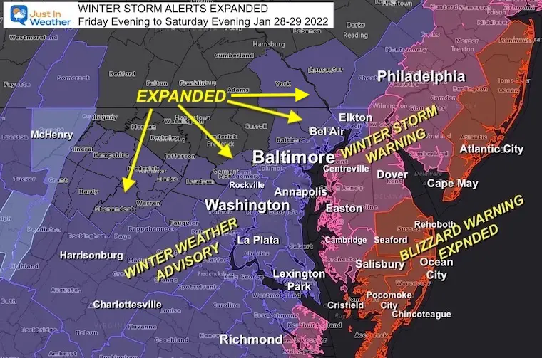
- Blizzard is qualified by 35 mph sustained winds with snow rates of 1”/Hr or higher for 3 consecutive hours.
- Winter Storm Warnings: Snow likely over 5 inches
- Winter Weather Advisory: Snow likely ‘at least’ 1 to 3 inches.
My UPDATED CALL FOR SNOWFALL
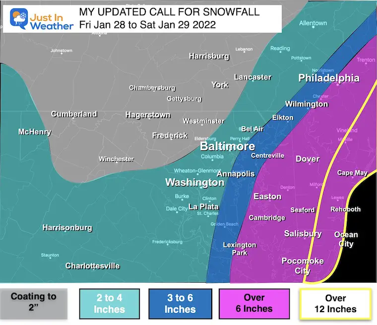
Take Away:
Metro Baltimore/Washington/I-95
West and North
Carroll/Frederick/Washington and Southern PA
- Coating to 2”
- Eastern York to Lancaster Co in my 2″ to 4″ range
Immediate West Bay Shore
Annapolis/Aberdeen/Elkton
Southern Maryland/Delmarva
Blizzard Area:
-
Best Chance to get Over 12 inches
-
BUT- Due To winds will be tough to measure
-
Snow Drifts 2 to 3 Ft
Also See:
Model Snow Maps Below
Notes:
- Snow showers will linger during the day in these same northern areas.
- During the day, Roads mostly OK
- Stickage becomes an issue AFTER 3 or 4 PM (as the sun angle gets low) where it has been snowing N and W
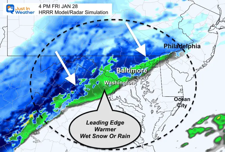
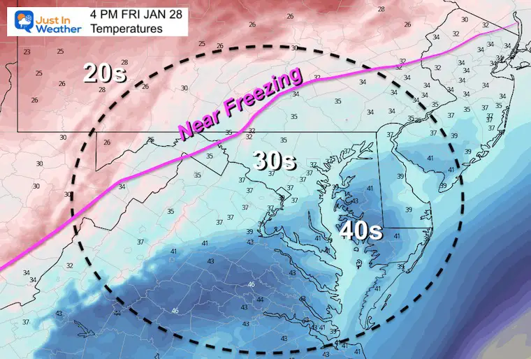
- Metro Areas: Above freezing then dropping this evening. Initial wet snow or rain = wet roads. Then more icy this evening when snow increases.
Saturday…
- Southern MD/DE/Beaches: Your heavy snow will be tonight AND Saturday!
- Blizzard Rages Full Force On The Coast Saturday Morning.
- Winds Crank Saturday!
- Blown and Drifting Snow= low visibility and hard to measure. Totals near 1 Ft, Drifts 2 to 3 FEET!!!
- Wind Chills will be BRUTAL
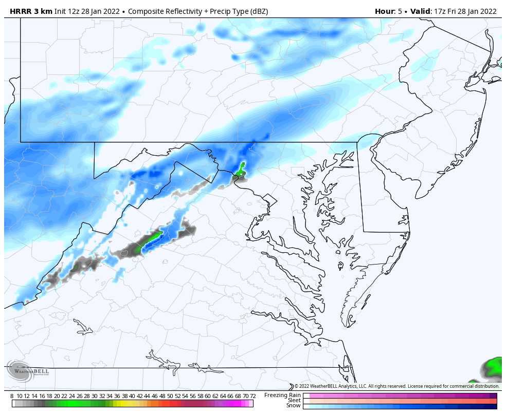
Snow Timeline
HRRR Model Animation
12 PM Fri to 12 PM Sat
Key Timeframe Snapshots
Radar AND Temperatures
4 PM Friday
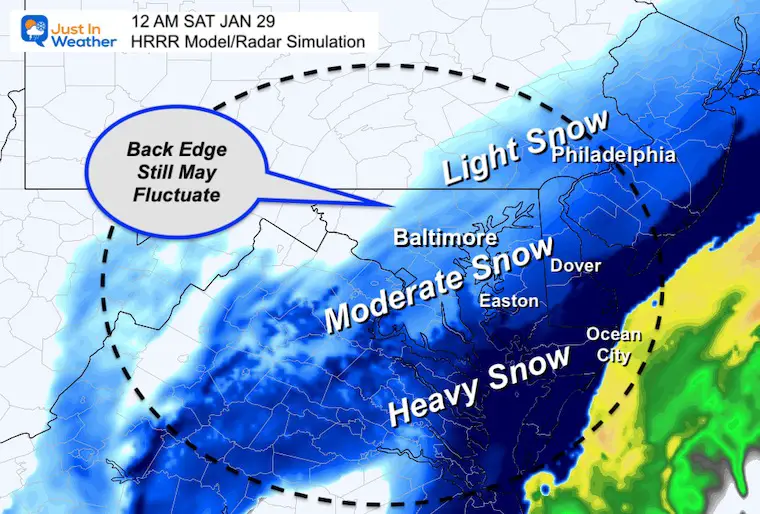
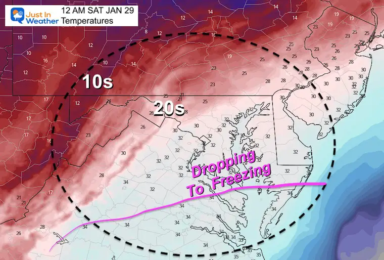
12 AM Saturday /Midnight
The impact region-wide will be late evening to early morning. So this midnight time frame supports who will be in on the accumulating snow.
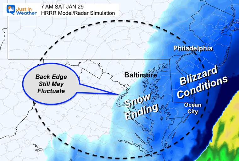
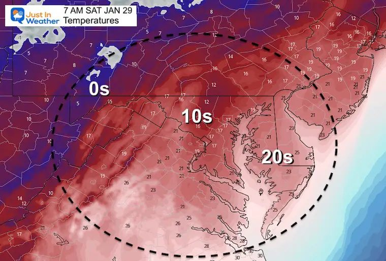
7 AM Saturday
Cold enough for full sticks, even with blowing snow over treated areas.
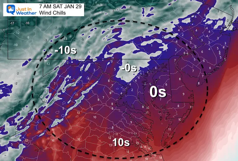
Wind Chill
At 7 AM Saturday, most of our region will ‘FEEL LIKE’ near or below ZERO!
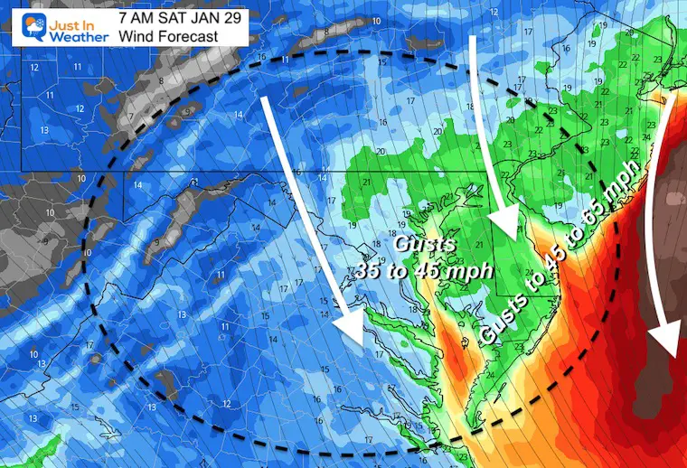
Wind Forecast Animation
7 PM FRI to 7 PM Sat
Increasing at the end of the storm through most of Saturday AFTER the storm move away.
BLOWING AND DRIFTING!
It is possible for SNOW DRIFTS in on Delmarva near the coast to be 2 to 3 Feet!
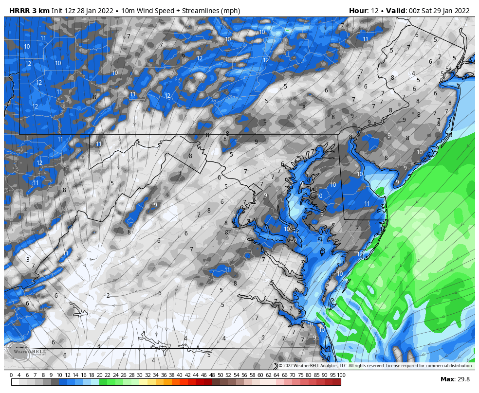
Wind Forecast NAM 3 Km
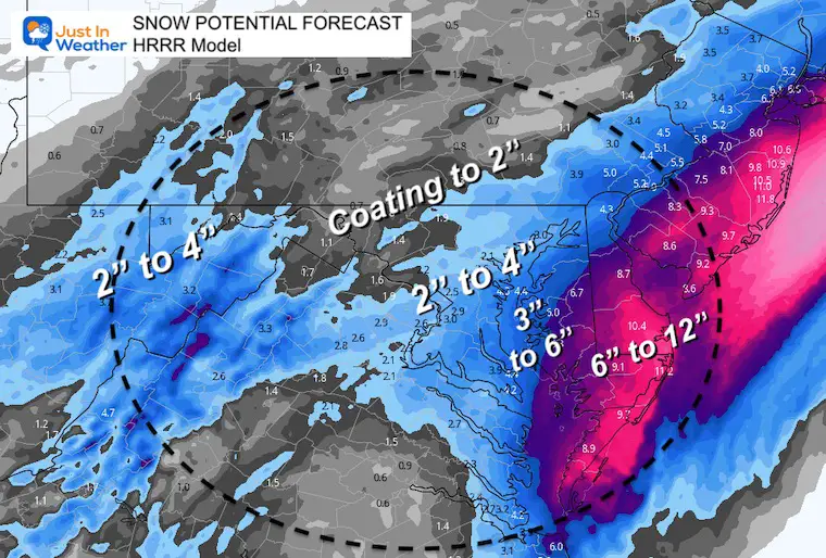
Snow Totals
HRRR Model
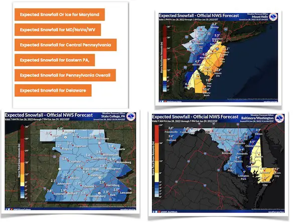
This is one of many model to consider for snow totals.
The beaches in the blizzard zone could earlier reach 1 Foot, but it will be blowing and drifting a lot. Drifts up to 2 or 3 feet are very plausible.
Farther west, the main boost is the 2 to 4 inches for metro Baltimore and Washington.
I will be upping my map shortly. This is criteria for the Winter Weather Advisory from NWS to be expanded west. I will let you know when they make that call.
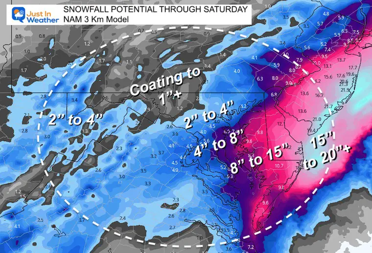
NAM 3 Km Model
This is what I shared in my first morning report.
Obviously these are MUCH HIGHER for the beaches.
Regardless, it will be hard to measure with the blowing and drifting.
Stay tuned…
Working on my new snow map now. I will issue that around noon.
Faith in the Flakes!
*Disclaimer due to frequent questions:
I am aware there are some spelling and grammar typos. I have made a few public statements over the years, but if you are new here you may have missed it:
I have dyslexia, and found out at my second year at Cornell. I didn’t stop me from getting my meteorology degree, and being first to get the AMS CBM in the Baltimore/Washington region.
I do miss my mistakes in my own proofreading. The autocorrect spell check on my computer sometimes does an injustice to make it worse.
All of the maps and information are accurate. The ‘wordy’ stuff can get sticky.
There is no editor that can check my work when I need it and have it ready to send out in a newsworthy timeline.
I accept this and perhaps proves what you read is really from me…
It’s part of my charm.
#FITF
ALSO SEE
ALL FITF GEAR

FITF THUNDERSNOW


Winter Outlook Series:
My Call For Snowfall

Last Winter Recap: My Old Outlook And Your Grades Of My Storm Forecasts


Please share your thoughts, best weather pics/video, or just keep in touch via social media


