Conditions: Baltimore, Maryland, 06/17/2025 12:40:02 pm
Temperature

72°

Cloudy with Mist and Fog

68°

Dew Point
Relative Humidity

87%

Feels Like

72°

Wind (S)

6mph

Air Pressure

30.03

Sun
Sun Rise

05:40 AM

Sun Set

08:35 PM

Day Length

14:55 Hours

Difference

0 min 14 sec gain

Moon
Moon Rise

12:32 AM

Moon Set

11:51 AM

Next: Last Quarter

Jun 18,2025

Moon Phase

Waning Gibbous

Climate
Average Low

63°

84°

Average High
Record Low

47°


(1964)

96°


(1939)
Record High
Conditions

Sunday Should Bring Snow Showers: Slider Timeline

Winter Weather
Forecast

Saturday January 22 2022

Afternoon Update

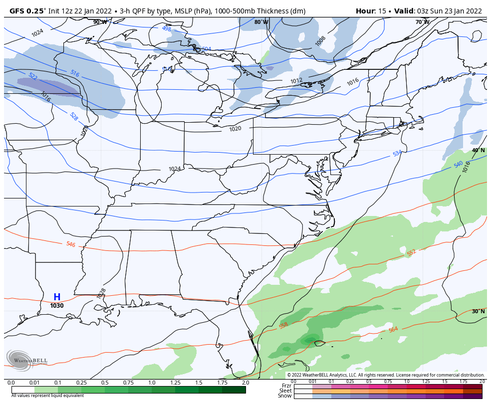
As we remain fully entrenched in this arctic air mass, the northern branch of the jet stream will active. This means fast moving Clipper systems that race through with snow showers. The moisture is limited, but there can be enough to drop a quick coating to one inch. That I something we can expect in our region on Sunday afternoon and evening. 

Saturday Afternoon Set Up

There are two clippers on the map today. The first is moving east through the Great Lakes. That will stay well to our north.  But the second one will be diving southward and reach us later on Sunday.


Active Pattern

We can see our Sunday Clipper followed by another Clipper on Tuesday. At first glance it looks like the snow hits a wall in the mountains, and has trouble passing eastward. That is pretty common, especially if the central Low Pressure passes to our north. 

January-22-weather-snow-clippers


Jet Stream Sunday

Closer inspection of the jet stream around 18,000 Ft, we can examine the vorticity or spin.  There should be a Vort Max, which can behave like a localized Low Pressure spin aloft, and enhance moisture crossing the mountains. 

This will ride a jet streak, a narrow river of faster moving air, passing over central Maryland. 

This should be enough to allow the moisture to cross over the mountains into metro Baltimore during the evening. 


NEW INFO

Click to See: SUNDAY MORNING REPORT


Radar Simulation Animation

Sunday Noon to Midnight

This model plot shows the moisture first passing north and east of Frederick, with support form higher terrain. 

Latter in the evening that Vort Max helps the snow showers expand farther east.  They will break up, but could still pass through metro Washington and Baltimore. 
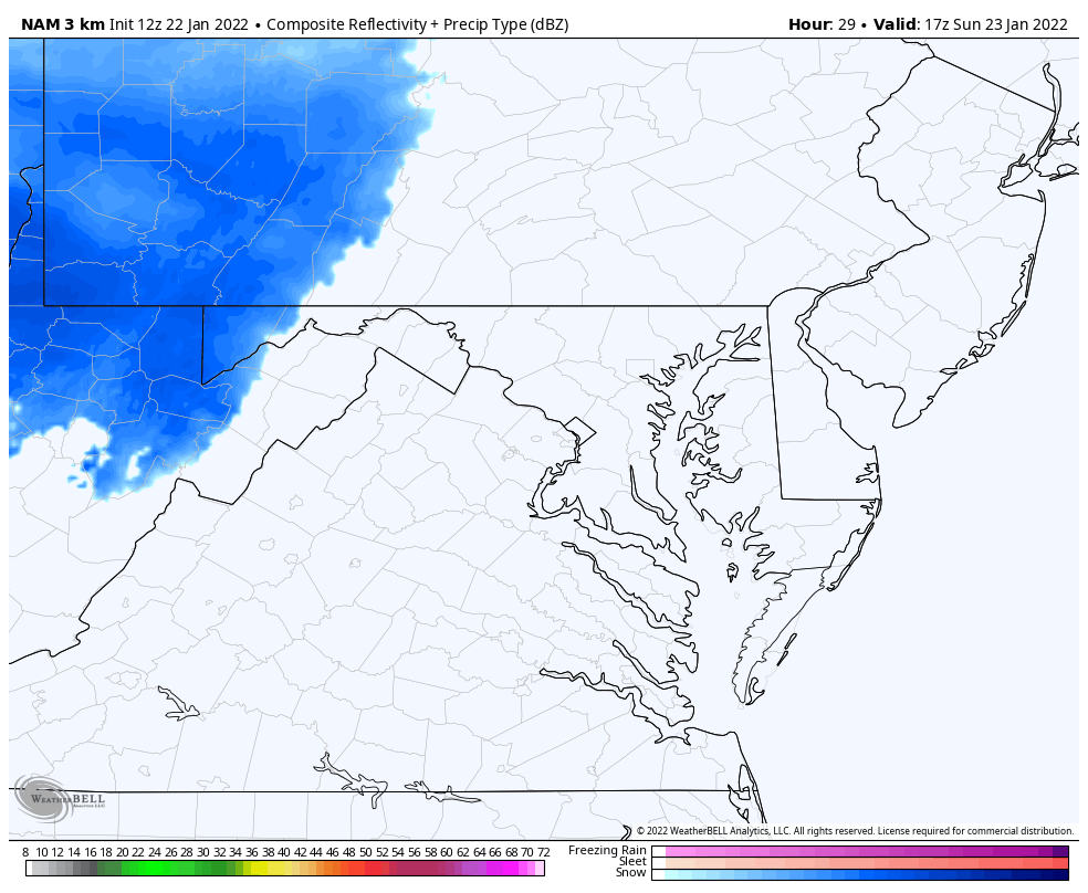
 

January-22-weather-snow-nam-sunday


Radar Simulation —> slider

3 PM to 11 PM

This model is NOT perfect, and can miss lighter bands of snow.


january-22-weather-radar-snow-sunday-pm-3
january-22-weather-radar-snow-sunday-pm-4
january-22-weather-radar-snow-sunday-pm-5
january-22-weather-radar-snow-sunday-pm-6
january-22-weather-radar-snow-sunday-pm-7
january-22-weather-radar-snow-sunday-pm-8
january-22-weather-radar-snow-sunday-pm-9
january-22-weather-radar-snow-sunday-pm-10
january-22-weather-radar-snow-sunday-pm-11
previous arrow
next arrow


Afternoon Temperatures 

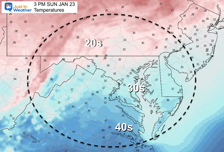
The air is cold enough for stickage. Under the snow it will be in the 20s, the flakes will be fluffy! 

That means it does’t take much moisture to produce a quick coating to 1 inch scattered across the region. 


TRAVEL

If you have plans to drive through western Maryland or Western PA, the snow will develop in the afternoon. Roads there will be slick. 

Timing farther east:

  • Along I-81 there maybe issues any time after 3 PM
  • Farther East: Frederick to York may have snow Burts any time after 4 or 5 PM
  • Metro Baltimore/Washington: Snow showers more prominent between 7 PM and Midnight.


Faith in the Flakes

If need be, I will post a snow map in my next reprot.


Weather posts straight to your inbox

Sign up and be the first to know!


ALSO SEE


What is Faith in the Flakes: History of December 5th Snow


ALL FITF GEAR


FITF THUNDERSNOW


Winter Outlook Series:

My Call For Snowfall


Last Winter Recap: My Old Outlook And Your Grades Of My Storm Forecasts

Winter Weather Page – Lots of resources


Solar Cycle Increasing Sunspots Suggests More Snow


Comparing 4 Different Farmer’s Almanacs: Majority colder winter outlook than NOAA


NOAA Winter Outlook- But Read The Fine Print


Signals For Early Start To Winter In November


Winter Outlook Series: La Nina Double Dip


Nor’easters May Give Hint For Winter La Nina Pattern


Winter Folklore Checklist


Please share your thoughts, best weather pics/video, or just keep in touch via social media

Facebook: Justin Berk, Meteorologist

Twitter: @JustinWeather

Instagram: justinweather