Conditions: Baltimore, Maryland, 04/28/2025 08:40:02 am
Temperature

52°

Mostly Sunny

38°

Dew Point
Relative Humidity

59%

Feels Like

52°

Wind (W)

5mph

Air Pressure

30.34

Sun
Sun Rise

06:11 AM

Sun Set

07:57 PM

Day Length

13:46 Hours

Difference

2 min 15 sec gain

Moon
Moon Rise

06:23 AM

Moon Set

09:35 PM

Next: First Quarter

May 04,2025

Moon Phase

New Moon

Climate
Average Low

46°

69°

Average High
Record Low

33°


(1998)

90°


(1957)
Record High
Conditions

Snow Forecast Monday From HRRR Model

Maryland Weather
Winter Weather
Forecast
Warnings

Sunday January 2 2022

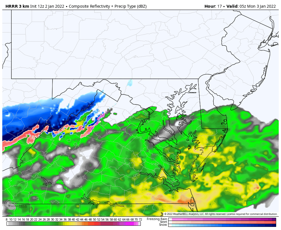
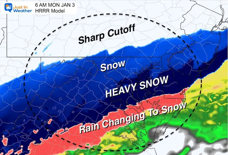
This update is simply the High Resolution Rapid Refresh Model (HRRR). It is one of our best tools when we get into the short range time frame of a weather event. It accounts for the latest model forecast and update each hour with new data.

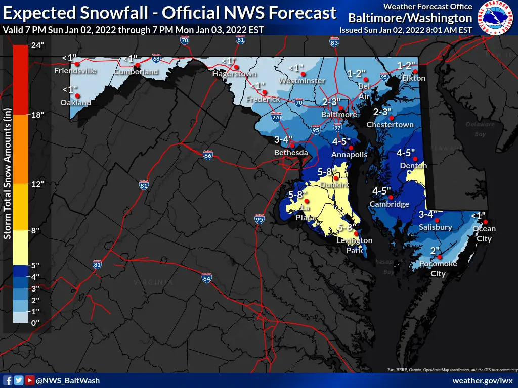
I want to emphasize that snow total forecasts often display HIGHER than we will verify. This is partially due to not accounting for the changeover melting time, and compression.

Below the maps is a link to the NWS Snow Forecast Page, where you can see the Regional NWS Offices Snow forecast maps including their Low and High End expectations. 


Winter Storm Watch

Note: This has been expanded to include Baltimore City to Montgomery Co.

Update to Warning and Advisories is likely to be issued this afternoon. 

The ‘Pay Attention’ region may be included in A Winter Weather Advisory.


Snow Forecast Animation: 

Monday Midnight to 6 PM

January-2-weather-snow-monday-hrrr-model


Morning Snapshot

Before Sunrise

  • The northern edge will try to sneak in to southern PA for just a few hours of the morning commute… 
  • There could be some impact there, but a sharp cutoff of the snow, then the band will retreat to the south. 
  • Changeover: Southern Maryland to the Beaches will start with rain and then transition to heavy snow during the morning. This is where there may be snow falling and not all sticking.


Snow ‘Potential’ HRRR Model

Note: It will be cold enough for stickage eventually. 

Initial melting and wet pavement will develop ice under the snowpack, making for more travel issues into the afternoon and overnight 


NWS Snow and Ice Forecasts

Official – High End – Low End – Onset Time – and Ice When needed

Click the map for the full package of maps

Save This Link: It will auto update as new maps are generated 


NOAA Winter Weather Maps

Click the map for the full package of maps

Save This Link: It will auto update as new maps are generated 


My Call For Snowfall On The Way This Afternoon 


Weather posts straight to your inbox

Sign up and be the first to know!


ALSO SEE


What is Faith in the Flakes: History of December 5th Snow


Winter Outlook Series:

My Call For Snowfall


Last Winter Recap: My Old Outlook And Your Grades Of My Storm Forecasts

Winter Weather Page – Lots of resources


Solar Cycle Increasing Sunspots Suggests More Snow


Comparing 4 Different Farmer’s Almanacs: Majority colder winter outlook than NOAA


NOAA Winter Outlook- But Read The Fine Print


Signals For Early Start To Winter In November


Winter Outlook Series: La Nina Double Dip


Nor’easters May Give Hint For Winter La Nina Pattern


Winter Folklore Checklist


Please share your thoughts, best weather pics/video, or just keep in touch via social media

Facebook: Justin Berk, Meteorologist

Twitter: @JustinWeather

Instagram: justinweather