February 4 2024
Sunday Morning Update
High Pressure building in and setting up shop will keep us dry with sunshine into most of next week. This is a boring week for a weather guy except by the water.
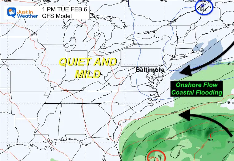
An onshore flow will keep water levels high with possible flooding on the West Shore of the Chesapeake Bay.
What about the rain or snow? The next chance for rain will be at the end of next week… It does not look impressive. Next week, we will watch for the active Western US stormy pattern to shift east the following week.
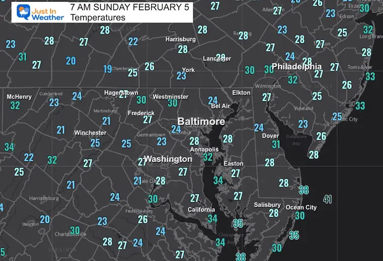
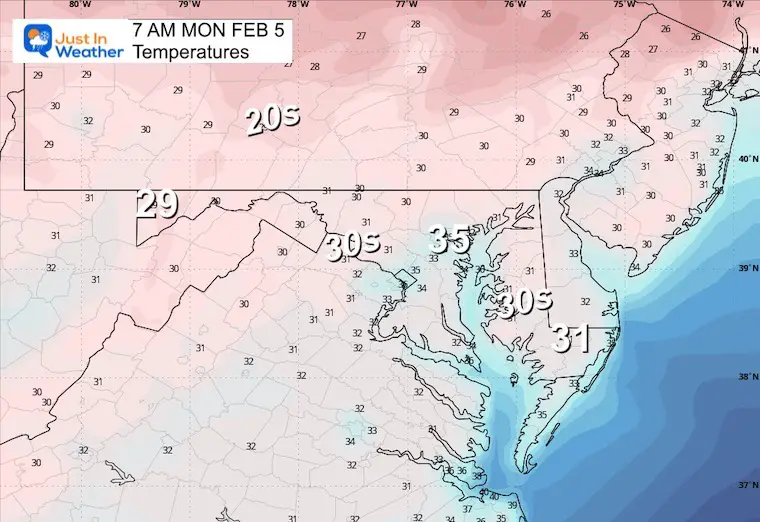
Morning Temperatures
Seasonably Cold to start the day… but it will warm up with the sunshine and light wind.
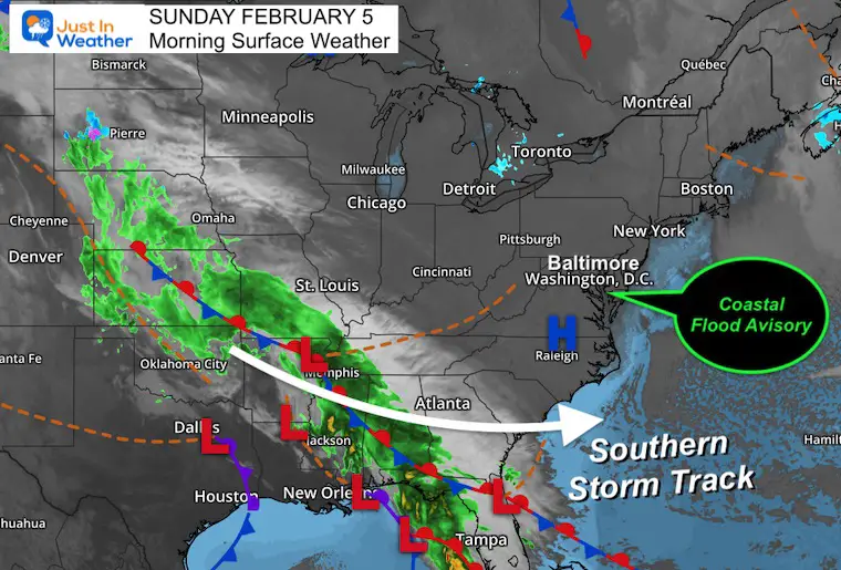
Morning Surface Weather
High Pressure is in control! This will set us up for the weekend and much of next week with sunshine.
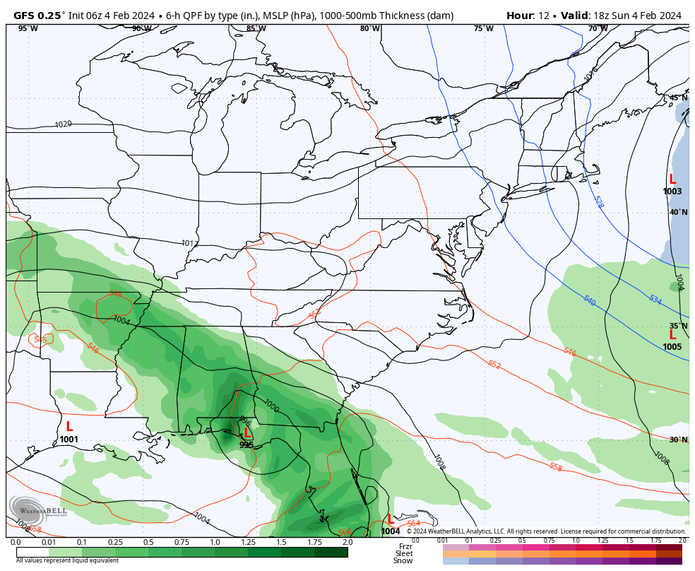
The storm pattern will track along the southern US.
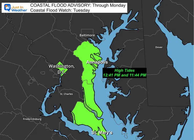
Coastal Flood Advisory
Water Levels may produce flooding for the Annapolis Docks through Monday. This will be followed by an increased onshore flow on Tuesday (see below), with a Coastal Flood Watch to follow.
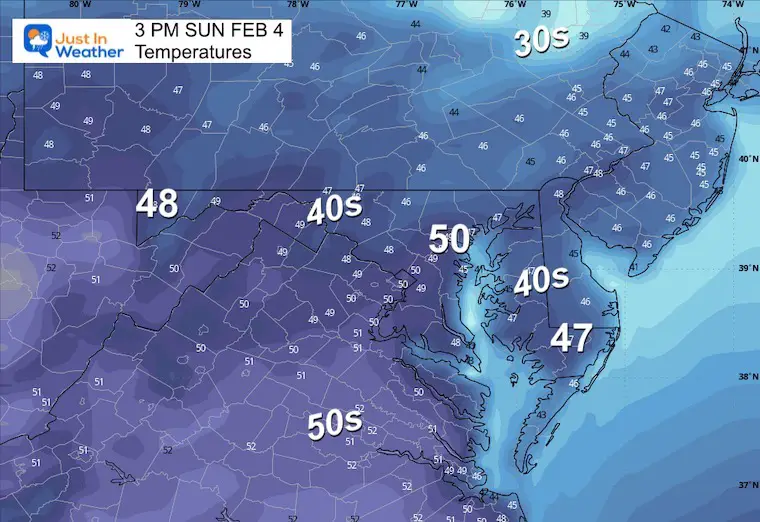
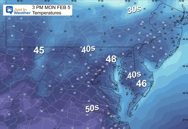
Afternoon Temperatures
CLIMATE DATA: Baltimore
TODAY February 4
Sunrise at 7:12 AM
Sunset at 5:29 PM
Normal Low in Baltimore: 25ºF
Record 4ºF in 1961
Normal High in Baltimore: 44ºF
Record 67ºF 2020
SEASONAL SNOW at BWI
9.1 inches
Recent Snow Reports
Recent Snow Reports
January 19 Recap
Click here for the maps and full report
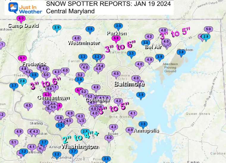
Jan 16 Snow Report
Click here or the map to see: The Snow Report Ending Jan 16

Monday Weather
More Sunshine: Near Seasonal Temps.
Morning Temperatures
Afternoon Temperatures
Next Week: Southern Track and Onshore Flow
Storm Animation Sunday to Wednesday
The storm pattern stays across the Gulf Coast States. We miss out on the rain and remain with sunshine. However, with the combination of High Pressure in Eastern Canada and that storm tracking off the Southeast US Coast, we will get wind and water flow FROM THE EAST.
Tuesday, February 6
This is what will keep our temperatures in check AND push higher water onto the western shore of the Chesapeake Bay.
Looking Ahead:
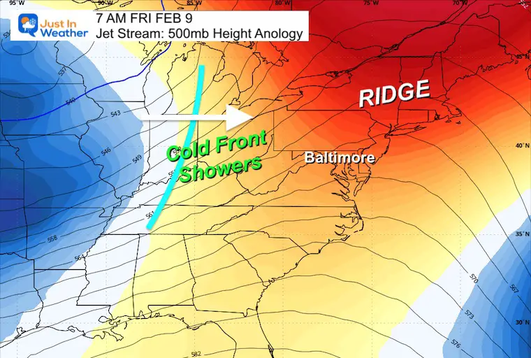
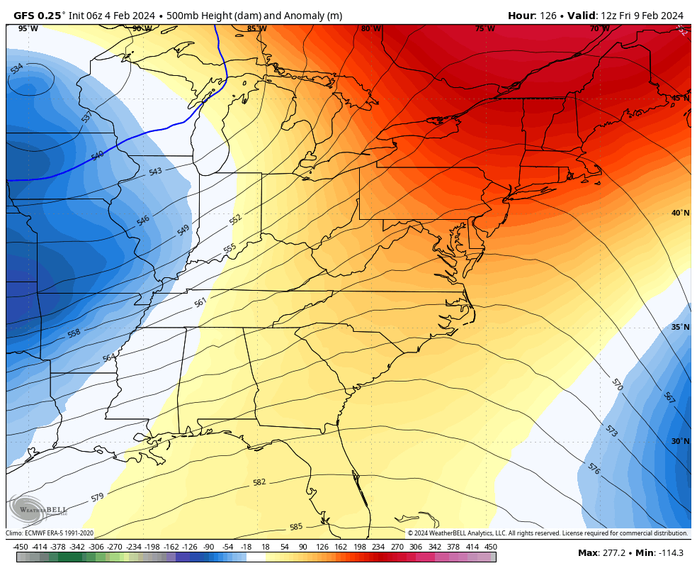
Jet Stream Friday, February 9
A Ridge in the Jet Stream will shift with a chance for rain on Friday… It may actually allow the wind shift to bring in warmer air over the weekend…
Jet Stream Animation Feb 9 to Feb 16
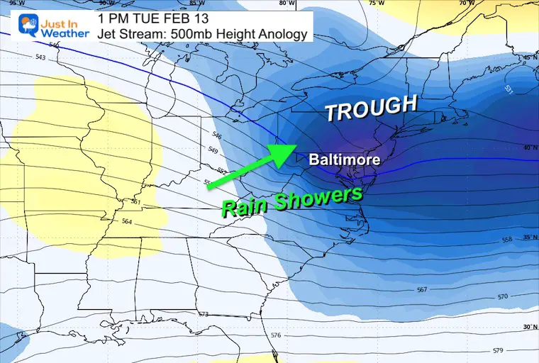
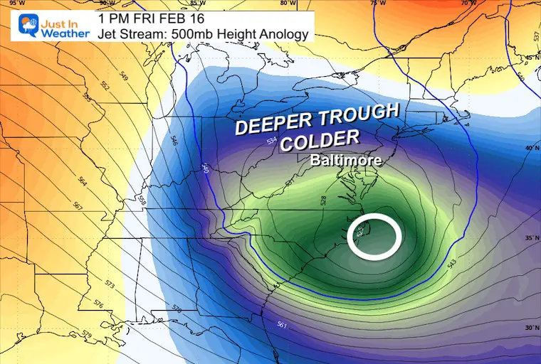
Next week the jet stream is expected to buckle, which will allow more activity with a few disturbances. This does not promise winter weather or snow.. but it does bring in the chance.
Jet Stream Snapshots
Tue Feb 13
Friday, Feb 16
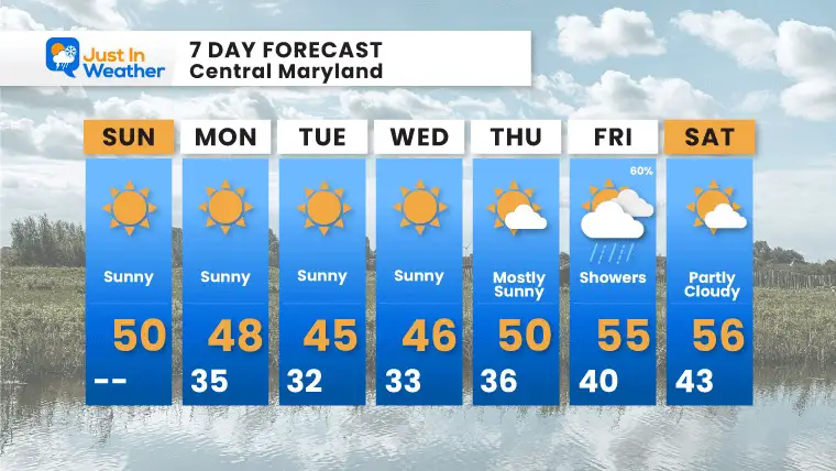
7 Day Outlook
This really looks like a very quiet and boring weather week. The temperatures will remain seasonably cool.. however, they may warm after the next system. That rain on Friday does not look impressive at this time.
Subscribe for eMail Alerts
Explore More
Maryland Snow Climate History And Other Winter Pages

STEM Assemblies/In School Fields Trips Are Back
Click to see more and ‘Book’ a visit to your school
RECENT Winter Outlook Reports:

Faith in the Flakes Gear

El Niño Winter Updates

Computer Models Support East Coast Storm Track

El Niño Advisory
The latest NOAA report is confident in a Very Strong event. Possibly HISTORIC! This refers to the temperatures in the Pacific, with impacts on the US Winter Storm Track.

Winter Weather Folklore: Top 20 and more signals from nature for snow.
NOAA’s Winter Outlook 2024
Winter Outlook 2024 From Two Farmers Almanacs Return to Cold and Snow
Please share your thoughts and best weather pics/videos, or just keep in touch via social media
RESTATING MY MESSAGE ABOUT DYSLEXIA
I am aware there are some spelling and grammar typos and occasional other glitches. I take responsibility for my mistakes and even the computer glitches I may miss. I have made a few public statements over the years, but if you are new here, you may have missed it: I have dyslexia and found out during my second year at Cornell University. It didn’t stop me from getting my meteorology degree and being the first to get the AMS CBM in the Baltimore/Washington region. One of my professors told me that I had made it that far without knowing and to not let it be a crutch going forward. That was Mark Wysocki, and he was absolutely correct! I do miss my mistakes in my own proofreading. The autocorrect spell check on my computer sometimes does an injustice to make it worse. I also can make mistakes in forecasting. No one is perfect at predicting the future. All of the maps and information are accurate. The ‘wordy’ stuff can get sticky. There has been no editor who can check my work when I need it and have it ready to send out in a newsworthy timeline. Barbara Werner is a member of the web team that helps me maintain this site. She has taken it upon herself to edit typos when she is available. That could be AFTER you read this. I accept this and perhaps proves what you read is really from me… It’s part of my charm. #FITF


