February 1 2024
Thursday Morning Update
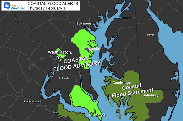
We will enter a quiet weather pattern, but there are some wrinkles. First, the high water on the Chesapeake Bay still has some places under a Coastal Food Advisory.
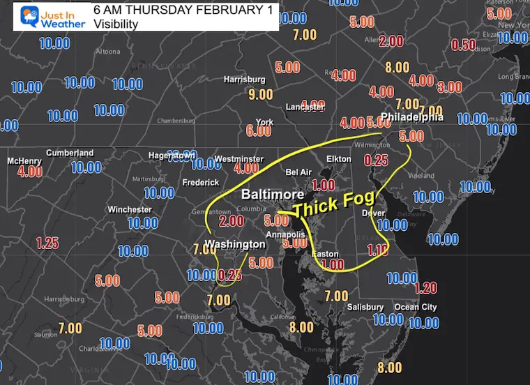
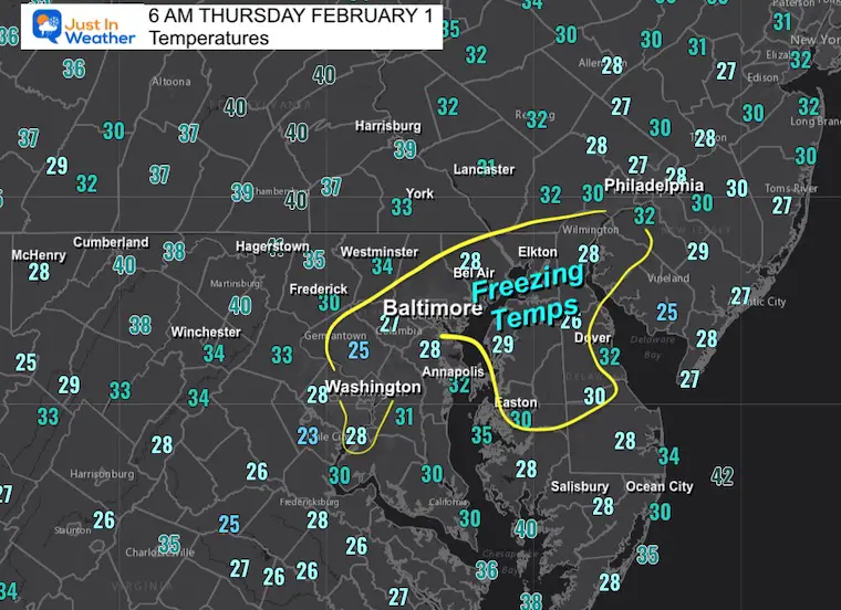
We also have some areas of fog with inland spots below freezing. This may have iced up some windshields that will need to be scraped off. Also, be alert for slippery steps and elevated surfaces.
A weak front will pass through after midnight, with light rain in the early morning of Friday. Then we get into a quiet weekend.
Next week shows a storm track to the south and just far enough off of the coast. But it is worth watching for an adjustment that could be closer. I’ll explain below.
Coastal Flood Advisory Until Midnight
Anne Arundel and St. Mary’s County
Tides two to two and a half feet above normal. The next high tide at Annapolis U.S. Naval Academy is at
9:41 AM and 9:25 PM.
Time of high total tides are approximate to the nearest hour.
Severn River at Annapolis
MLLW Categories – Minor 2.6 ft, Moderate 3.3 ft, Major 6.0 ft
MHHW Categories – Minor 1.2 ft, Moderate 1.9 ft, Major 4.6 ft
WHAT…Up to one-half foot of inundation above ground level expected in low-lying areas due to tidal flooding.
* WHERE…Shoreline in Anne Arundel County.
* WHEN…From 7 AM this morning to midnight EST tonight, especially around the time of high tide.
* IMPACTS…At 2.8 feet, flooding of some of the parking area near Dock Street in Annapolis may occur, with water surrounding the Alex Haley Memorial.
…COASTAL FLOOD STATEMENT REMAINS IN EFFECT UNTIL 8 AM EST THIS
MORNING…
* WHAT…Up to one-half foot of inundation above ground level in low-lying areas near shorelines and tidal waterways.
* WHERE…Dorchester, Wicomico and Somerset Counties.
* WHEN…Until 8 AM EST Thursday.
* IMPACTS…Shallow flooding is possible in the most vulnerable locations near the waterfront and shoreline.
Morning Visibility
Areas of thick fog in metro Baltimore and around the Chesapeake Bay.
Morning Temperatures
Some areas inland are below freezing. The droplets may ice up some windshields, steps, and some elevated surfaces.
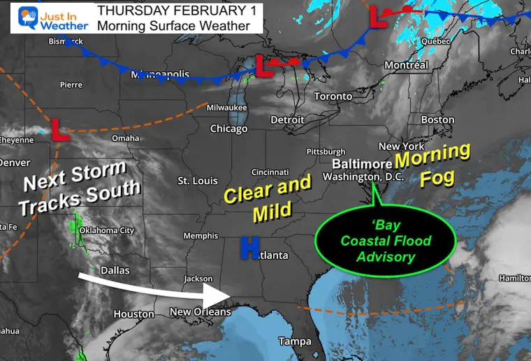
Morning Surface Weather
There are areas of fog that will give way to sunshine today.
The next cold front will be a quick visit. Much of the Eastern half of the nation is quiet, and we will get in on that. Then the storm track will shift to the south along the Gulf Coast.
Afternoon Temperatures
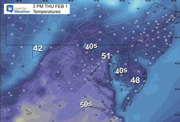
CLIMATE DATA: Baltimore
TODAY February 1
Sunrise at 7:14 AM
Sunset at 5:27 PM
Normal Low in Baltimore: 25ºF
Record 7ºF in 1965
Normal High in Baltimore: 44ºF
Record 75ºF 2002
SEASONAL SNOW at BWI
9.1 inches
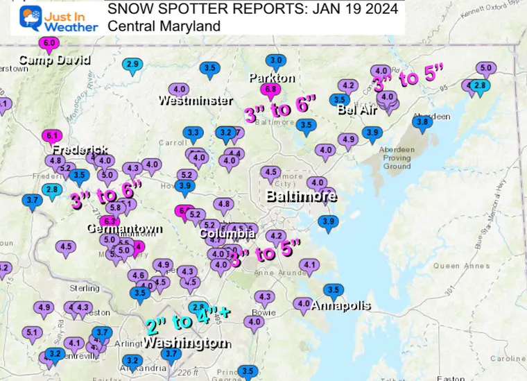
Recent Snow Reports
January 19 Recap
Click here for the maps and full report
Jan 16 Snow Report
Click here or the map to see: The Snow Report Ending Jan 16

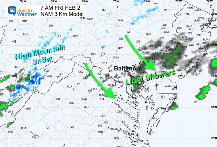
Thursday Weather
RADAR SIMULATION: Midnight to 3 PM
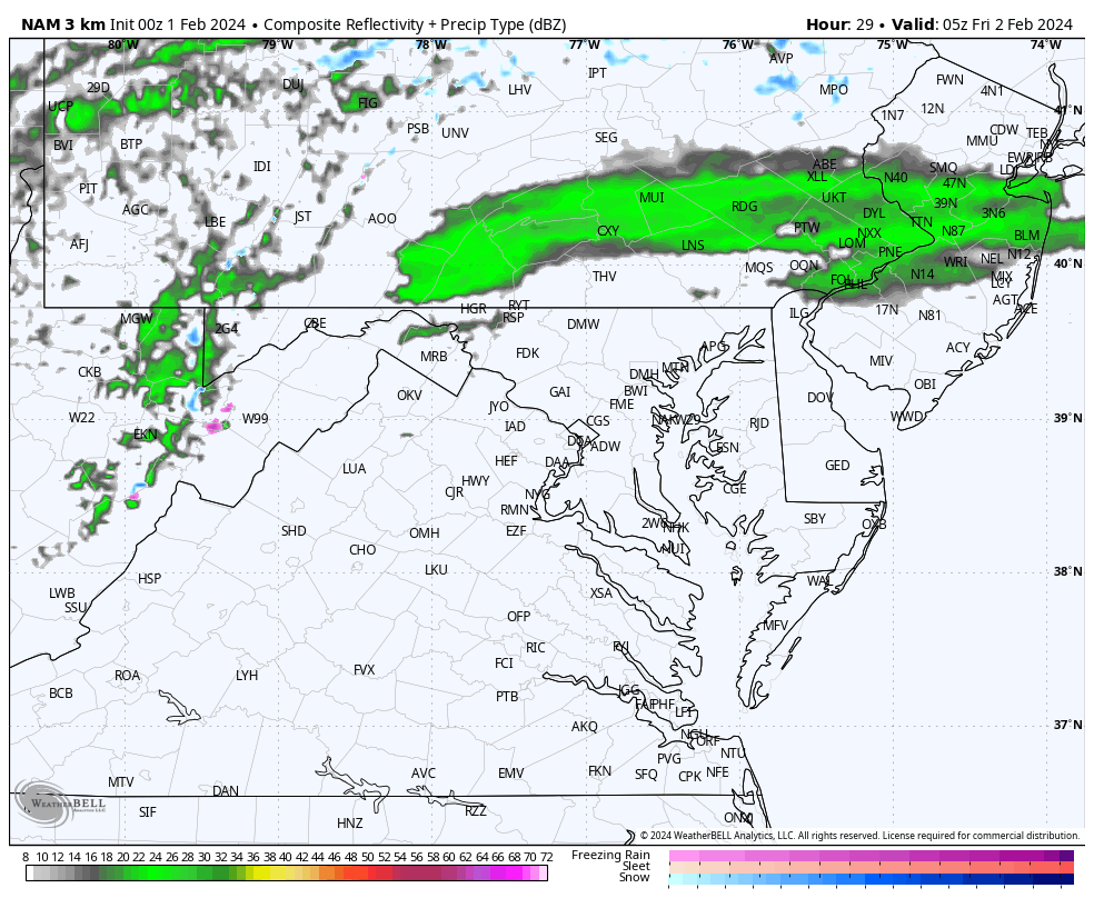
3 AM Snapshot
The band of rain is likely to arrive when most are sleeping.
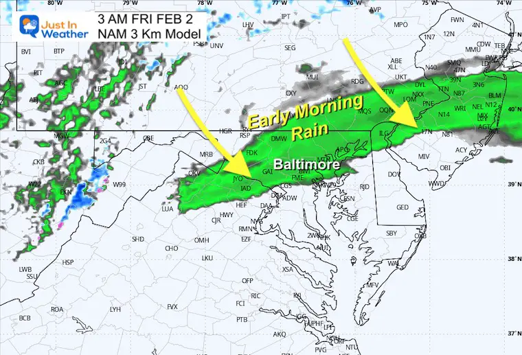
7 AM Snapshot
Leftover sprinkles for the morning commute in metro Baltimore.
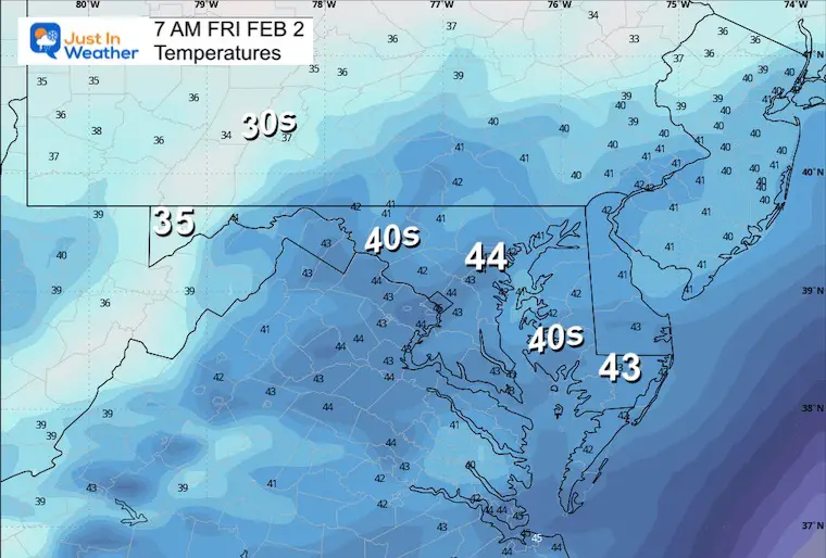
Morning Temperatures
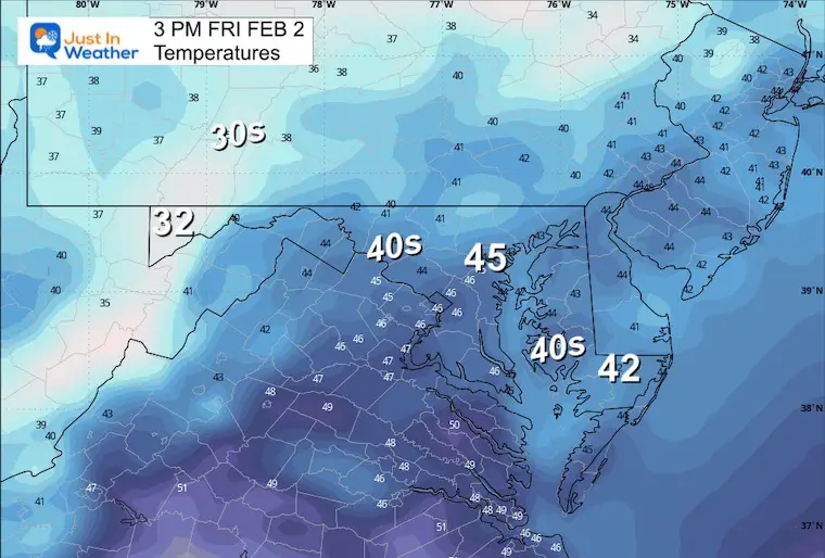
Afternoon Temperatures
Looking Ahead:
Sunday Afternoon to Tuesday Afternoon
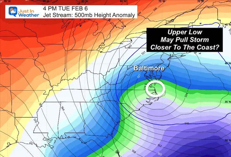
The southern storm track is set up for rapid development off the East Coast on Tuesday. This appears just out of reach but too close for comfort. This far out, modeling tends to have errors, and there could be a tendency for the timing to possibly verify this farther west.
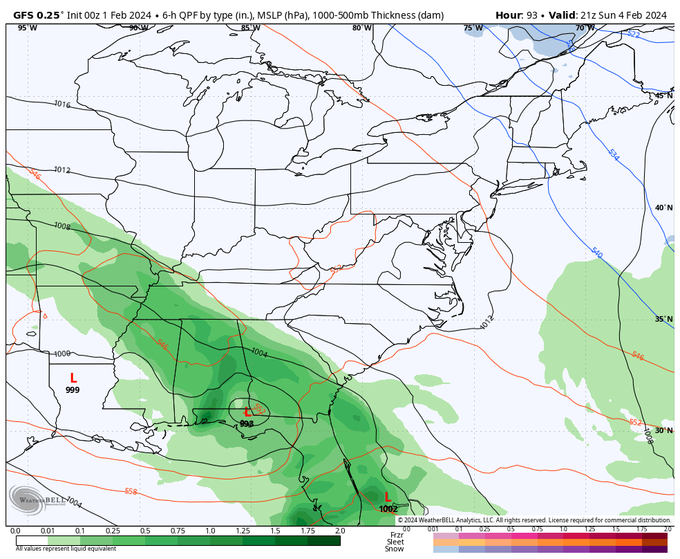
Jet Stream Tuesday
The Upper-Level Low in the Mid-Atlantic is one feature I am watching. In this position, it can pull moisture farther west/closer to us.
The other possibility is that the timing of the Upper Low will be faster. If so, then it could pull that storm closer to the coast and sooner. If that plays out, then I would watch for any adjustment a day earlier if we get in on this event. Stay tuned.
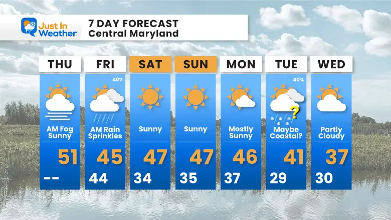
7 Day Outlook
Brief rain showers Friday morning… Then a quiet weekend.
Next week is worth watching IF that storm pattern pulls westward. For now, it is simply a potential but not a promise.
Subscribe for eMail Alerts
Explore More
Maryland Snow Climate History And Other Winter Pages

STEM Assemblies/In School Fields Trips Are Back
Click to see more and ‘Book’ a visit to your school
RECENT Winter Outlook Reports:

Faith in the Flakes Gear

El Niño Winter Updates

Computer Models Support East Coast Storm Track

El Niño Advisory
The latest NOAA report is confident in a Very Strong event. Possibly HISTORIC! This refers to the temperatures in the Pacific, with impacts on the US Winter Storm Track.

Winter Weather Folklore: Top 20 and more signals from nature for snow.
NOAA’s Winter Outlook 2024
Winter Outlook 2024 From Two Farmers Almanacs Return to Cold and Snow
Please share your thoughts and best weather pics/videos, or just keep in touch via social media
RESTATING MY MESSAGE ABOUT DYSLEXIA
I am aware there are some spelling and grammar typos and occasional other glitches. I take responsibility for my mistakes and even the computer glitches I may miss. I have made a few public statements over the years, but if you are new here, you may have missed it: I have dyslexia and found out during my second year at Cornell University. It didn’t stop me from getting my meteorology degree and being the first to get the AMS CBM in the Baltimore/Washington region. One of my professors told me that I had made it that far without knowing and to not let it be a crutch going forward. That was Mark Wysocki, and he was absolutely correct! I do miss my mistakes in my own proofreading. The autocorrect spell check on my computer sometimes does an injustice to make it worse. I also can make mistakes in forecasting. No one is perfect at predicting the future. All of the maps and information are accurate. The ‘wordy’ stuff can get sticky. There has been no editor who can check my work when I need it and have it ready to send out in a newsworthy timeline. Barbara Werner is a member of the web team that helps me maintain this site. She has taken it upon herself to edit typos when she is available. That could be AFTER you read this. I accept this and perhaps proves what you read is really from me… It’s part of my charm. #FITF


