


May 4 Chilly And Wet Weekend: Live Radar
Saturday May 4 Morning Report May the 4th Be With You! There is a definite change in the Force we all will notice this morning. A band of rain has…
Thursday Afternoon, January 18 2024
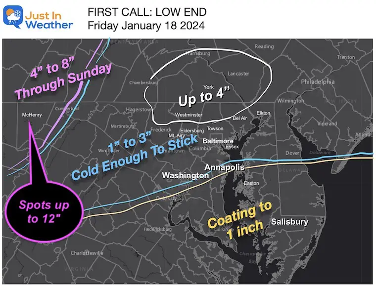
The trend is your friend, and the trend is ramping up a little like our past storm on Tuesday. This is not the exact same event, but the atmosphere is primed for us to get a moderate accumulating snow that will impact schools and travel.
Truth be known: I have been hedging my call for a few reasons.
Here is a brief look…. If I make any updates to my personal snow map, I will post that in my evening report.
The National Weather Service has finally expanded the alerts into Maryland and Virginia. This follows the logic I have been sharing and my forecast as well.
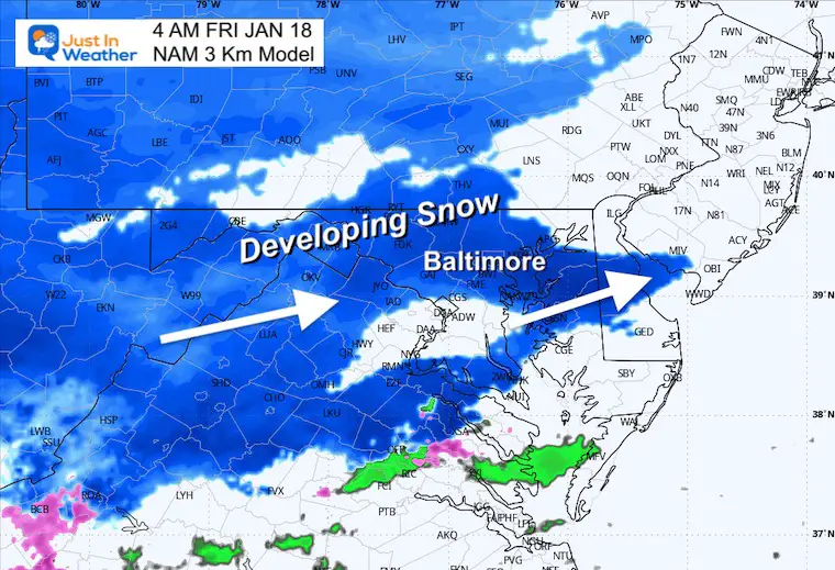
Plan for snow to arrive before sunrise, with the biggest impact in metro areas during the morning to early afternoon.
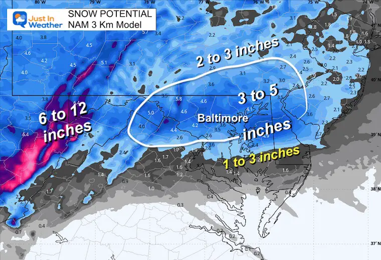
A Winter Storm Warning in the higher mountains with 6 to 12 inches of snow possible through Saturday.
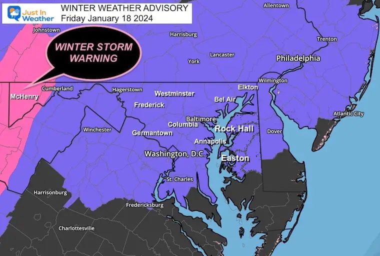
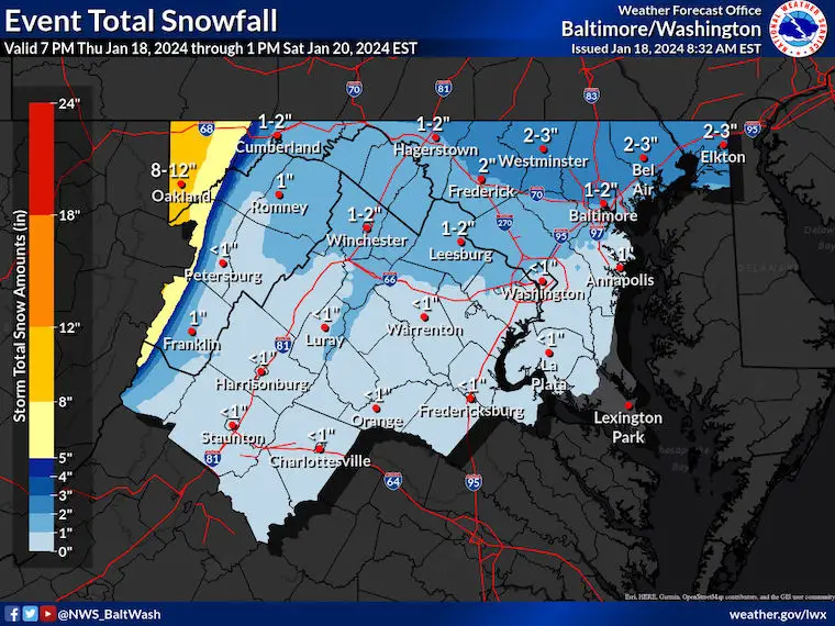
1 AM Friday to 4 PM Saturday
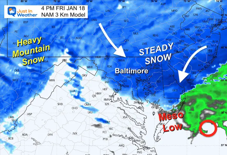
Here, we can see the snow expand from the Ohio Valley before sunrise. The Surface Low will track off North Carolina and well east, far away from the snow. Look closely, and you will see the Meso-Low develop near Cape May, NJ, between Noon and 4 PM.
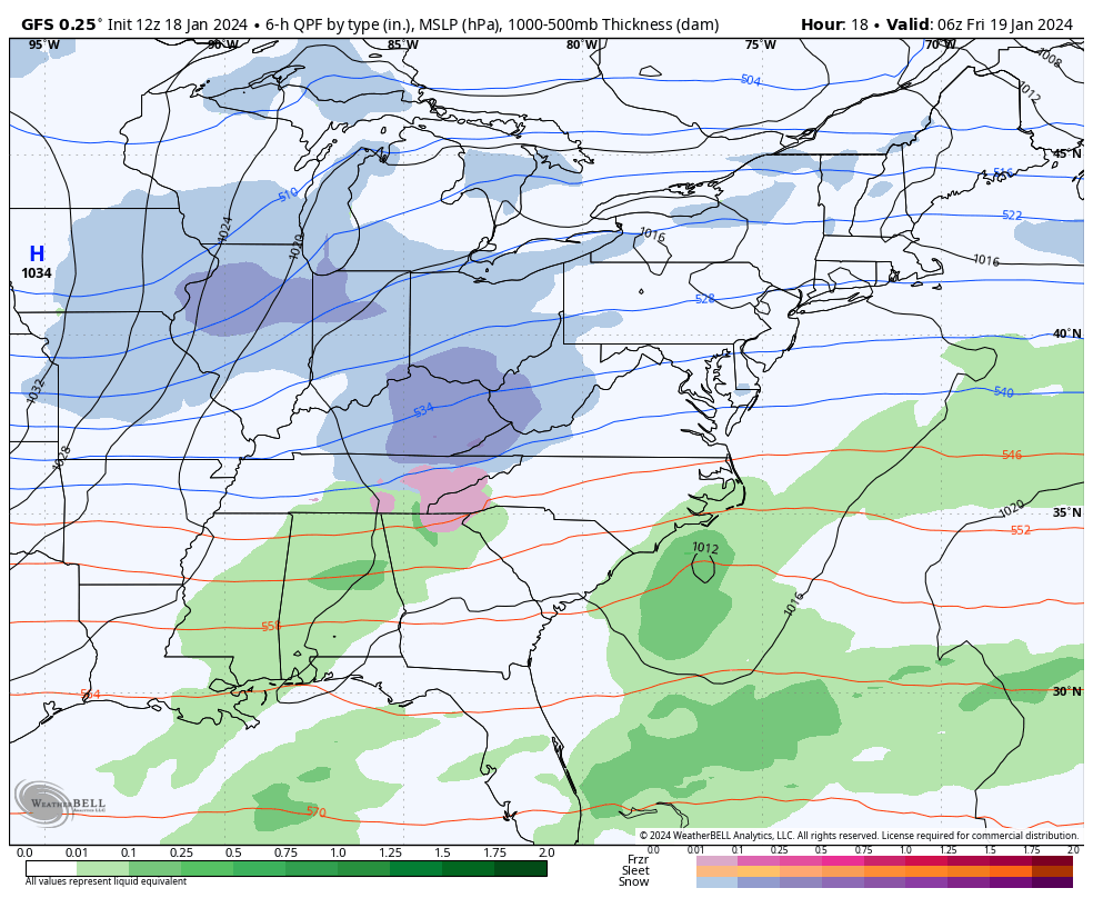
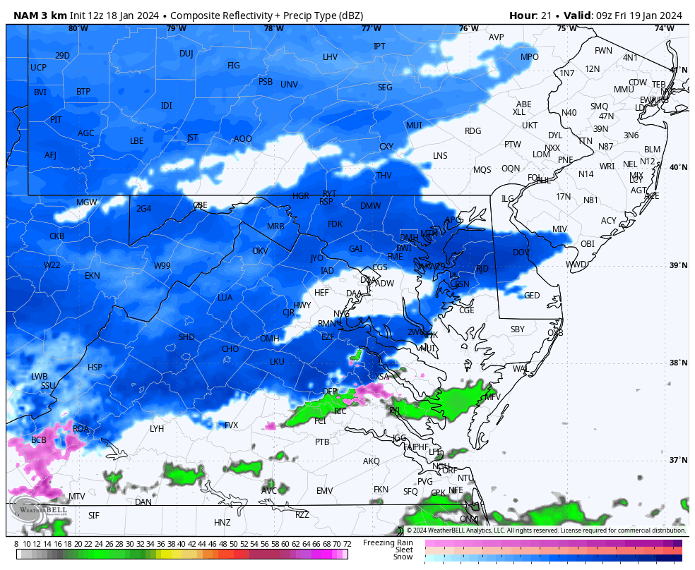
This is the Meso-Low and expanded banding of Moderate Snow. We will compare to the High Resolution NAM 3 Km Model below that has this West over central Maryland.
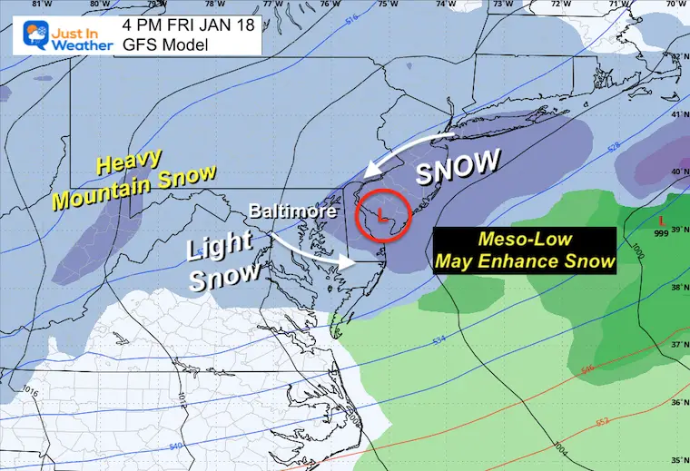
I am seeing the snow expand into metro areas between 3 and 5 AM, then remain steady most of the day. The expanding snow for the afternoon is a reflection of that Meso-Low. See snapshots below.
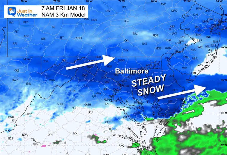
Steady snow in place for sunrise and whoever needs to commute. It will be slick!
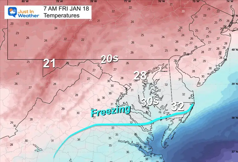
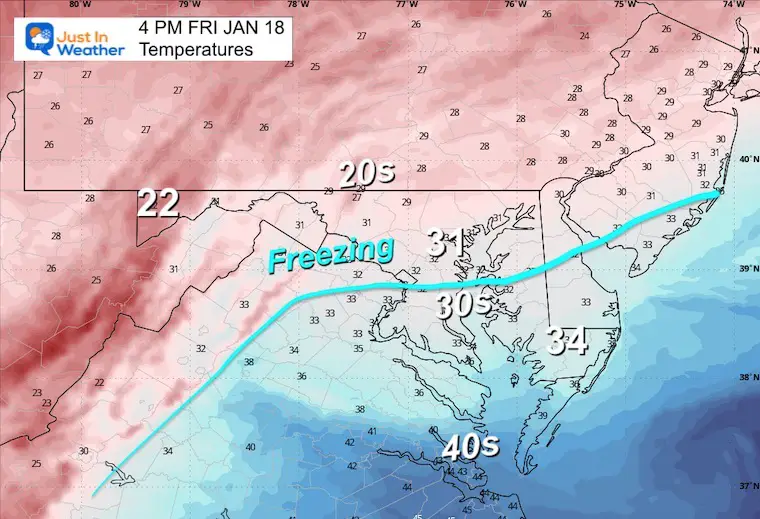
Most will be below freezing, which will maximize the stickage.
Steady snow should continue to fall…
If that Meso-Low takes form, it will be developing around this time. This location is closer to Ocean City.
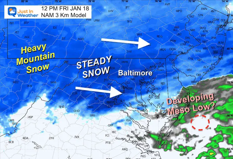
If that Meso-Low Forms, it may be nearly stationary. That would mean enhancing snow but remaining in nearly the same locations for a few hours.
The freezing Line may try to get close to Baltimore… but if that Meso-Low Forms, it will pull in colder air from the west and keep this mostly snow… except for Southern Maryland.
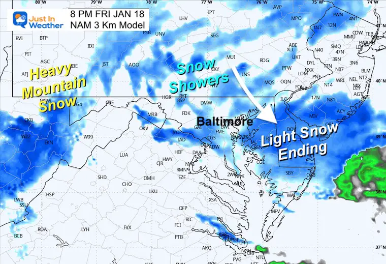
Snow finally tapering off to showers and furries.
I will show the other models in my next report.
This is my LOW END Confidence range. I am NOT changing it yet. If I do, I will include that in my evening report.
Stand by to see if they adjust this evening.
NWS Sterling seems to be holding on the higher side of 2 to 3 inches across northern MD.
Washington to Annapolis may be closer to 1 inch.
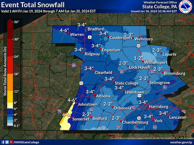
Mountains – This burst will be due to colder temps/higher ratios and longer duration snow into Saturday.
Looks like 3 to 4 inches across Adams, York, and Lancaster Counties.
Click here or the map to see: The Snow Report Ending Jan 16


Computer Models Support East Coast Storm Track

The latest NOAA report is confident in a Very Strong event. Possibly HISTORIC! This refers to the temperatures in the Pacific, with impacts on the US Winter Storm Track.

Winter Weather Folklore: Top 20 and more signals from nature for snow.
Winter Outlook 2024 From Two Farmers Almanacs Return to Cold and Snow


Click to see more and ‘Book’ a visit to your school 
I am aware there are some spelling and grammar typos and occasional other glitches. I take responsibility for my mistakes and even the computer glitches I may miss. I have made a few public statements over the years, but if you are new here, you may have missed it: I have dyslexia and found out during my second year at Cornell University. It didn’t stop me from getting my meteorology degree and being the first to get the AMS CBM in the Baltimore/Washington region. One of my professors told me that I had made it that far without knowing and to not let it be a crutch going forward. That was Mark Wysocki, and he was absolutely correct! I do miss my mistakes in my own proofreading. The autocorrect spell check on my computer sometimes does an injustice to make it worse. I also can make mistakes in forecasting. No one is perfect at predicting the future. All of the maps and information are accurate. The ‘wordy’ stuff can get sticky. There has been no editor who can check my work when I need it and have it ready to send out in a newsworthy timeline. Barbara Werner is a member of the web team that helps me maintain this site. She has taken it upon herself to edit typos when she is available. That could be AFTER you read this. I accept this and perhaps proves what you read is really from me… It’s part of my charm. #FITF