January 7, 2024
Sunday Morning Update
I want to share some good news to kick off this report. Today is the day sunset gets back to 5 PM for Baltimore. Will we see it? Well, there will be a smattering of clouds with colder winds as the storm departs. But there will be sunny breaks in central and eastern areas.
The energy left over in the mountains may produce snow showers across Southern PA that could clip northeastern Maryland briefly. The far western Maryland mountains will benefit from a few inches of snow for Wisp and around Deep Creek Lake.
Snow Stuff:
The last storm underperformed for our local inland areas, but it did verify in the mountains. I will have my recap and ask you to grade my forecast later today.
Looking ahead, the pattern is NOT promising for winter lovers. This is one week with two storms that will bring mostly rain. But the next three weeks feature our coldest temperatures of the year climatologically. So, there is still plenty of time ahead.
Live Snow Cam: McHenry, MD
This webcam is positioned at The Greene Turtle Deep Creek Lake and shows Wisp Resort, including a zoomed-in view of Squirrel Cage, The Face, the terrain park, Boulder, the mountain coaster, the tubing park, and a shot of McHenry Cove at Deep Creek Lake!
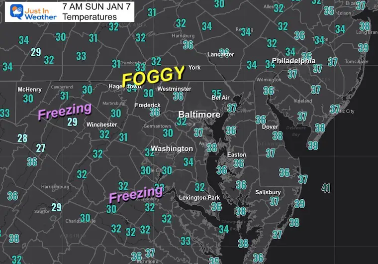
Temperatures at 7 AM
Areas of Fog inland!
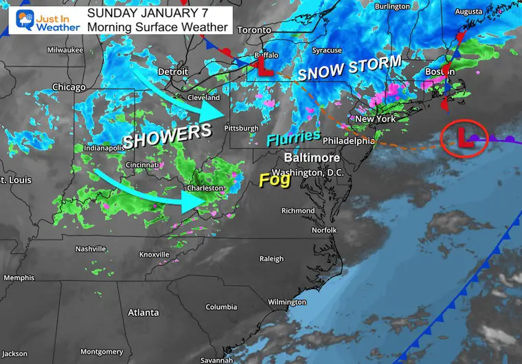
Morning Surface Weather
Low Pressure was located South of Boston and moving away from the US coast. The snow storm verified across central PA to New England (inland).
Lingering snow showers and flurries did pass through south central PA.
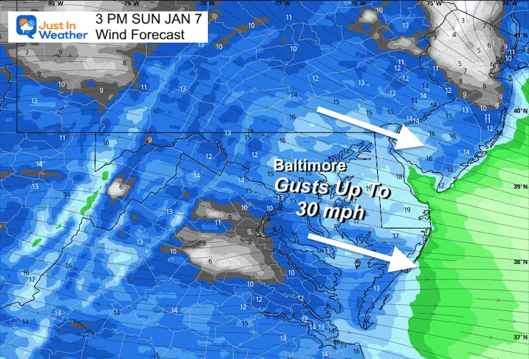
An upper-level disturbance has a broad area of rain and snow showers across the Ohio Valley. This will bring fresh snow accumulation to western Maryland and nearby ski areas, while gusty winds will spread across the entire Mid-Atlantic this afternoon.
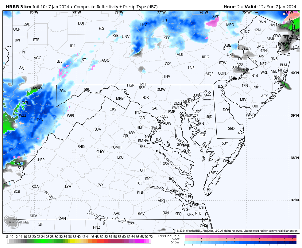
Radar Simulation
8 AM to 7 PM
Southern PA may get clipped with flurries or snow showers.
Garrett County, MD will be in the snow zone all day and get a few additional inches.
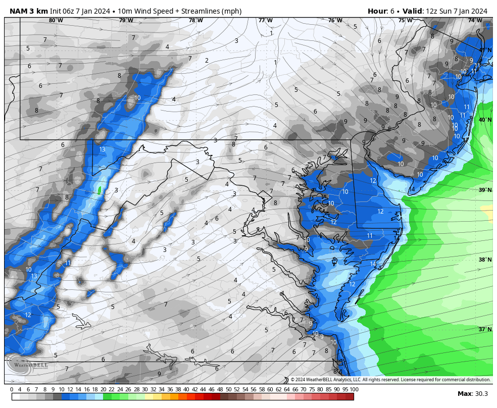
Wind Forecast Animation
Sunday 7 AM to 7 PM
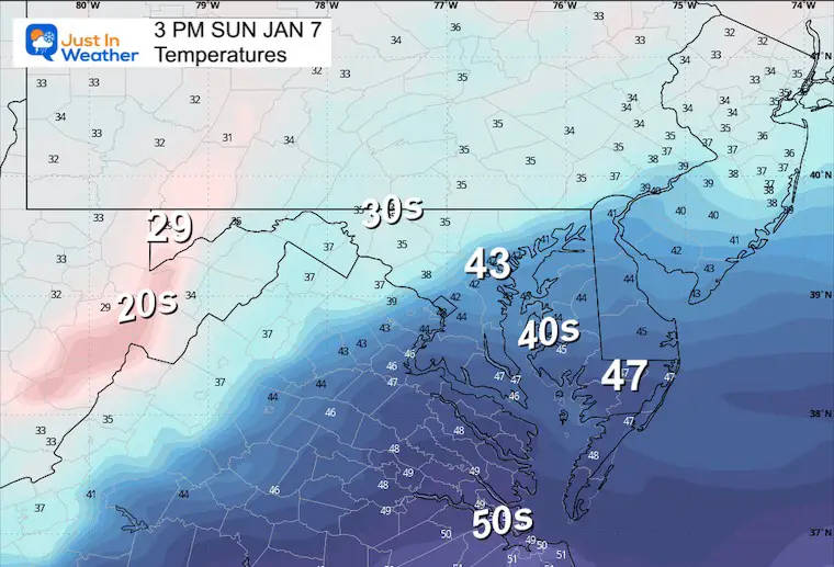
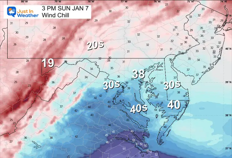
3 PM: Afternoon Snapshots
Wind Forecast
Temperatures
Wind Chills
CLIMATE DATA: Baltimore
TODAY January 7
Sunrise at 7:26 AM
Sunset at 5:00 PM
Normal Low in Baltimore: 26ºF
Record 1ºF in 2018
Normal High in Baltimore: 43ºF
Record 74ºF 1950
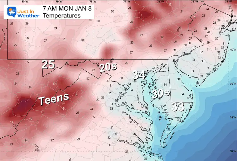
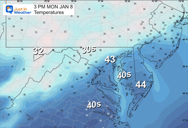
Monday Temperatures
Morning
Afternoon
NEXT STORMS:
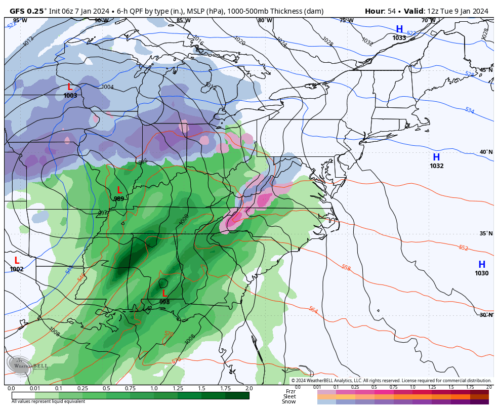
Both storms will track west and bring us mostly rain. The only question I have now is the timing. I have noticed systems arriving earlier than first thought… and in both of these cases, it will be around sunrise. That can tap into overnight colder air inland… So we may have the typical ‘inland areas’ to focus on for a brief winter impact.
Tue-Wed
This tracks farther west. Some inland mix may fall at the start, but it looks like mostly rain.
Snapshots:
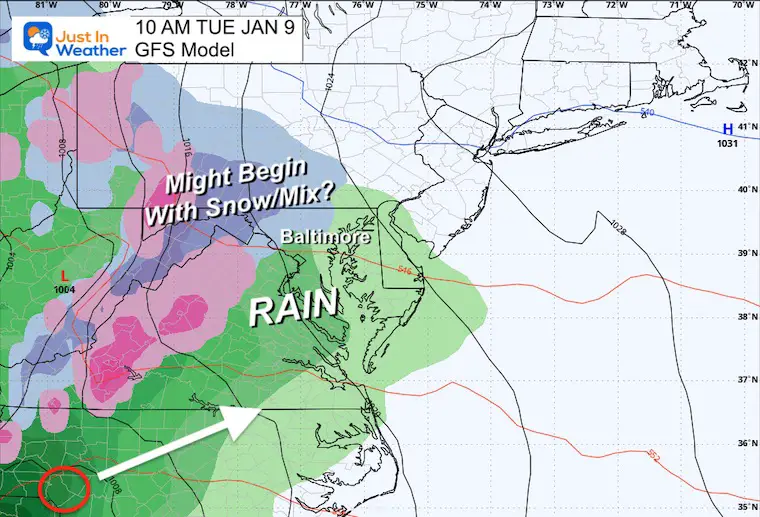
Tuesday Morning
Depending on the arrival time, we may need to focus attention on some wintry impact for the colder inland areas.
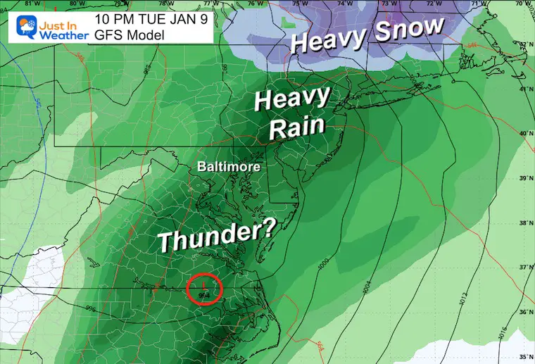
Tuesday Night
This may bring flooding rain, AND some rumbles of thunder.
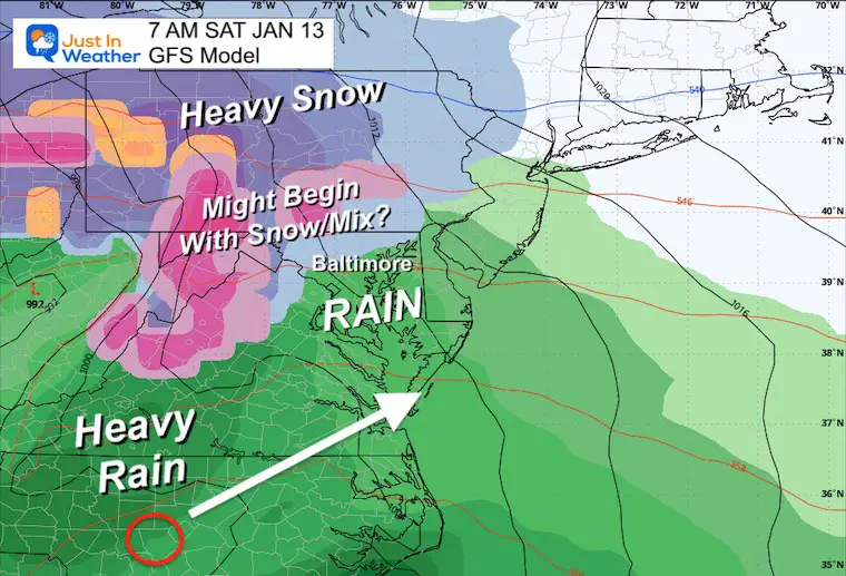
NEXT STORM: Saturday
A repeat with mostly a heavy rain event?
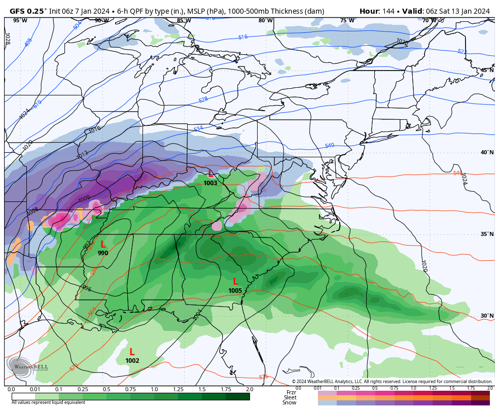
Snapshots:
Saturday Morning
AGAIN: Depending on the arrival time, we may need to focus attention on some wintry impact for the colder inland areas.
Saturday Afternoon
Another heavy rain event is likely.

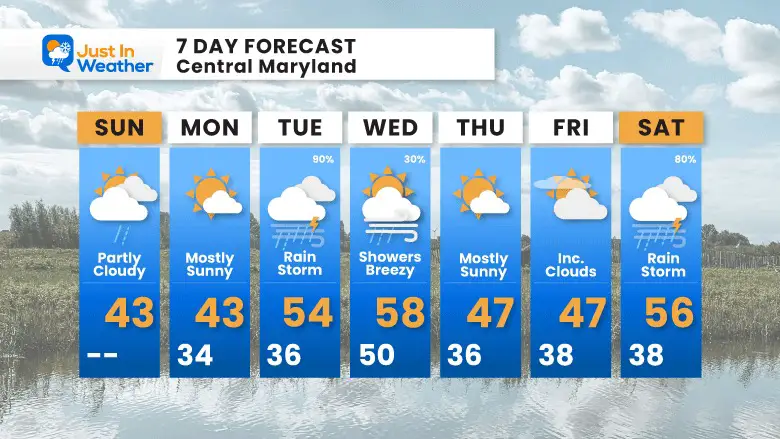
7 Day Forecast
This is not a promising winter pattern this week. There will be two strong storms passing to our west. While there could be a brief wintry mix inland, the focus will be on heavy rain and perhaps some rumbles of thunder.
Main storm days: Tuesday and Saturday
Subscribe for eMail Alerts
RECENT Winter Outlook Reports:

El Niño Winter Updates

Computer Models Support East Coast Storm Track

El Niño Advisory
The latest NOAA report is confident in a Very Strong event. Possibly HISTORIC! This refers to the temperatures in the Pacific, with impacts on the US Winter Storm Track.

Winter Weather Folklore: Top 20 and more signals from nature for snow.
NOAA’s Winter Outlook 2024
Winter Outlook 2024 From Two Farmers Almanacs Return to Cold and Snow
Explore More
Maryland Snow Climate History And Other Winter Pages

Faith in the Flakes Gear

STEM Assemblies/In School Fields Trips Are Back
Click to see more and ‘Book’ a visit to your school

Please share your thoughts and best weather pics/videos, or just keep in touch via social media
RESTATING MY MESSAGE ABOUT DYSLEXIA
I am aware there are some spelling and grammar typos and occasional other glitches. I take responsibility for my mistakes and even the computer glitches I may miss. I have made a few public statements over the years, but if you are new here, you may have missed it: I have dyslexia and found out during my second year at Cornell University. It didn’t stop me from getting my meteorology degree and being the first to get the AMS CBM in the Baltimore/Washington region. One of my professors told me that I had made it that far without knowing and to not let it be a crutch going forward. That was Mark Wysocki, and he was absolutely correct! I do miss my mistakes in my own proofreading. The autocorrect spell check on my computer sometimes does an injustice to make it worse. I also can make mistakes in forecasting. No one is perfect at predicting the future. All of the maps and information are accurate. The ‘wordy’ stuff can get sticky. There has been no editor who can check my work when I need it and have it ready to send out in a newsworthy timeline. Barbara Werner is a member of the web team that helps me maintain this site. She has taken it upon herself to edit typos when she is available. That could be AFTER you read this. I accept this and perhaps proves what you read is really from me… It’s part of my charm.
#FITF


