The first snow event of the season was yet another partial event for the Mid-Atlantic. Like last winter, the impact was not for the urban areas, but it did produce snow and ice for the normal colder suburbs in the hills and mountains west and north.
My report here is to account for how much snow fell but also to allow you to grade my forecast. I believe I know where I was wrong and right, but the messaging is something I can always use feedback on.
Below, I will compare the National Weather Service Snow Spotter Maps to my forecast maps. The Poll feature is not working, so I am going to ask you to visit my Facebook page and comment there.
The funny thing is that I was overly cautious to talk about this storm until within one week, and even then, I refused to show the computer model maps with high snow amounts in central Maryland.
When I see the word BUST, I feel like it is meant as a middle finger for the forecast. After rereading my maps and words, many areas in the population center were not expected to get snow, so perhaps the ‘bust’ people wrote because it was their towns missing out?!?
Good News: Snow For Local Ski Areas
- Roundtop: 5 inches
- Liberty = 6 inches
- Whitetail = 6 to 8 inches
- Seven Springs = 5 inches
- Wisp = 4 inches
What went right:
- My First Call map was very close to varying for over 80% of our region.
- I emphasized the warm Bay temps and urban temps to bring the cities and I-95 wet roads.
- The heavy snow zone was verified.
What went wrong:
- The night before the storm, I saw air temperatures drop 2 to 3 degrees colder than expected.
- I looked at The National Weather Service extending Winter Weather Advisories farther east, and actually trended my totals in some areas higher to catch up to their totals.
- Low Pressure was closer with the pass by Maryland, and as a result, warmer air was pushed a little farther north. This changed inland snow to sleet and freezing rain sooner.
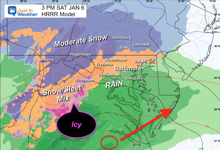
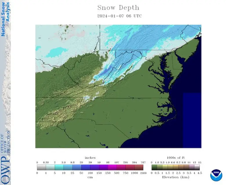
Mid Atlantic Snow Report Map
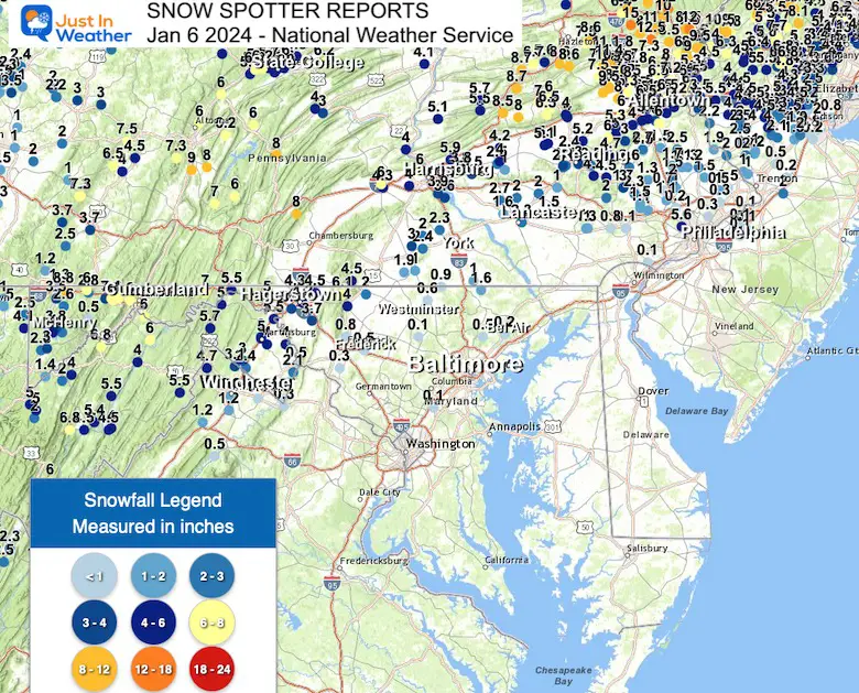
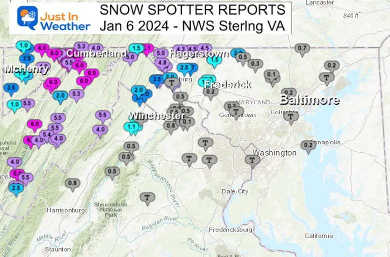
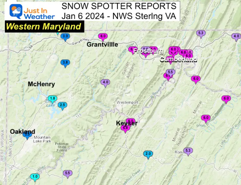
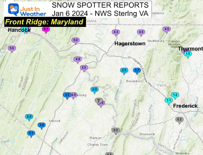
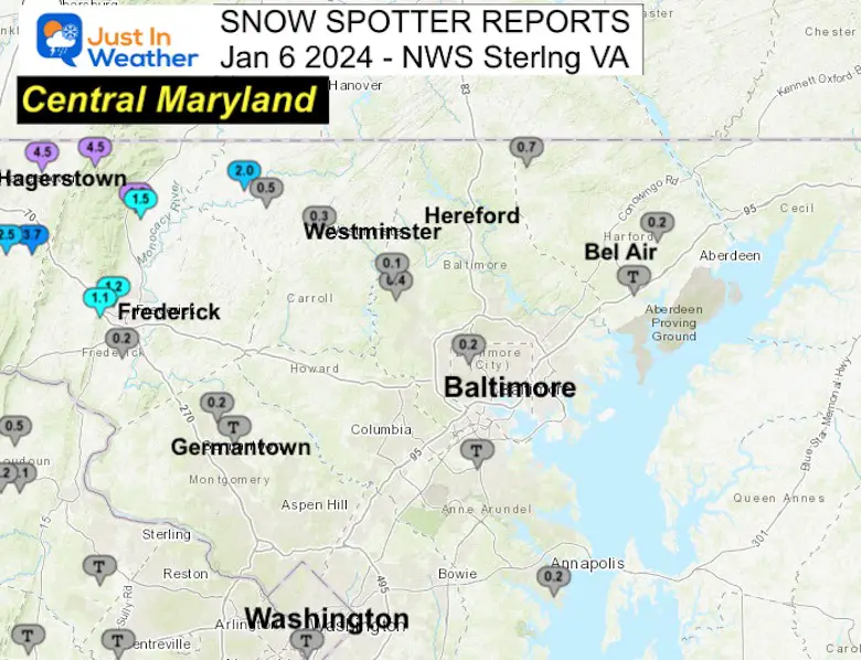
Snow Spotters: Maryland and Virginia from NWS in Sterling
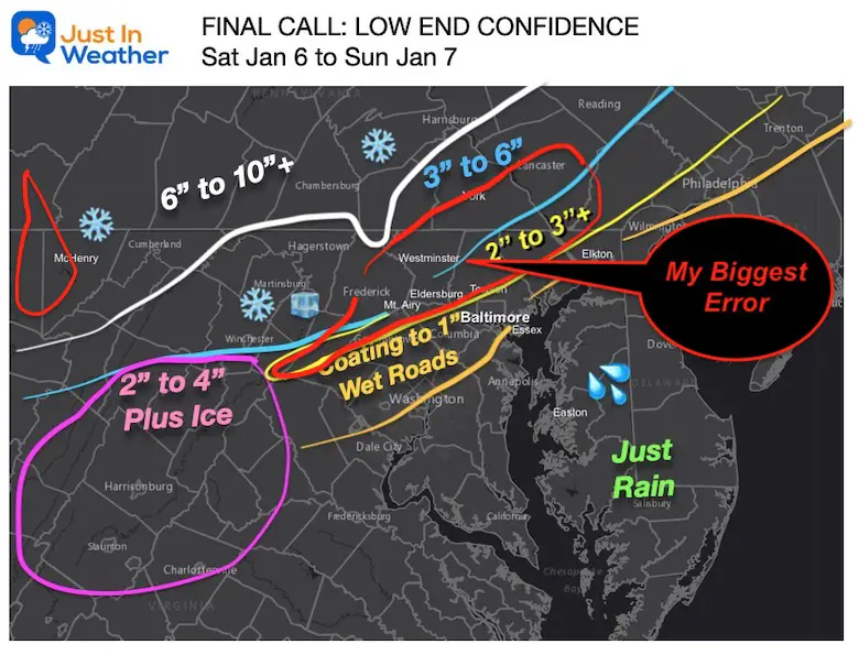
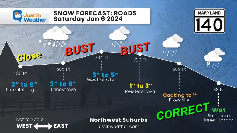
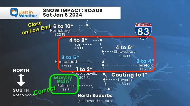
My Maps with the highlighted BUST areas:
My First Call (made Jan 3)
The low-end confidence number.
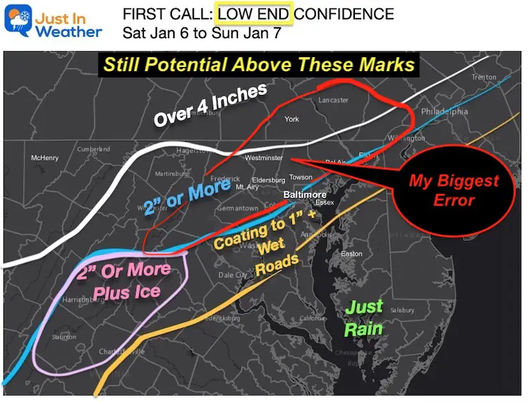
My Final Call
This is where I increased some of my totals. Biggest bust for Northern Baltimore, Carroll, and Frederick Counties in Maryland. Plus Southern Adams, York, and Lancaster Counties in PA.
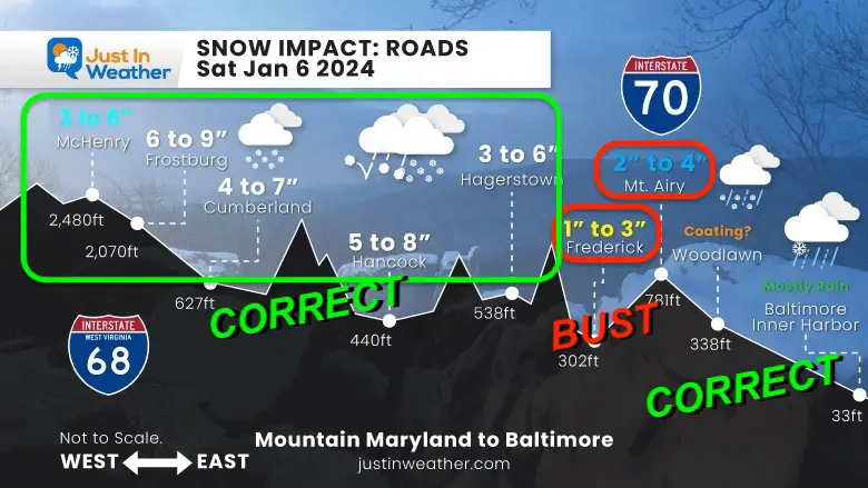
My Profile Maps
Maryland I-68 to I-70
Snow Spotters Western Maryland
4 to 6+ inches in purple shading.
Central Maryland Rt 140
Interstate 83 from Baltimore to York
York County ranged from 1 to 3 inches of snow.
The Roundtop ski area did pick up 5 inches of snow.
Snow Spotter Maps from NWS Sterling VA: MD and VA
MARYLAND
…Allegany County…
Cumberland 7.0 431 PM 1/06 Trained Spotter
Ridgeley 1 NW 6.6 439 PM 1/06 Trained Spotter
Potomac Park 2 NW 6.5 352 PM 1/06 Trained Spotter
La Vale 1 E 6.0 402 PM 1/06 Trained Spotter
Frostburg 2 ENE 6.0 545 PM 1/06 Trained Spotter
La Vale 1 S 6.0 524 PM 1/06 Trained Spotter
La Vale 6.0 413 PM 1/06 Dept of Highways
Brady 1 SW 6.0 514 PM 1/06 Trained Spotter
Frostburg NW 6.0 536 PM 1/06 Trained Spotter
Cumberland 1 SSE 6.0 500 PM 1/06 Trained Spotter
Cresaptown SSW 5.5 300 PM 1/06 Trained Spotter
Wolfe Mill 2 NNE 5.3 247 PM 1/06 Trained Spotter
Frostburg 5.0 417 PM 1/06 Trained Spotter
Flintstone 4.0 214 PM 1/06 Public
…Anne Arundel County…
Eastport 1 S 0.2 131 PM 1/06 Trained Spotter
Bwi Airport T 100 PM 1/06 Official NWS Obs
…Baltimore County…
Reisterstown 1 NW 0.4 500 PM 1/06 CoCoRaHS
Reisterstown 2 NW 0.1 1259 PM 1/06 Co-Op Observer
…Baltimore City…
Pikesville 3 SE 0.2 1135 AM 1/06 Trained Spotter
…Carroll County…
Taneytown NE 2.0 200 PM 1/06 Trained Spotter
Uniontown 3 N 0.5 1247 PM 1/06 Trained Spotter
Westminster 0.3 1230 PM 1/06 Trained Spotter
…Frederick County…
Thurmont NW 4.0 548 PM 1/06 Public
Thurmont 1 SSE 1.5 145 PM 1/06 Trained Spotter
Bloomfield 2 WSW 1.2 130 PM 1/06 NWS Employee
Braddock Heights 2 N 1.1 152 PM 1/06 Trained Spotter
Ballenger Creek WSW 0.2 130 PM 1/06 Trained Spotter
…Garrett County…
Grantsville 3 E 6.0 723 PM 1/06 Trained Spotter
Frostburg 3 WNW 6.0 405 PM 1/06 Trained Spotter
Barton 4.0 400 PM 1/06 Public
Accident 4 E 3.8 401 PM 1/06 Public
Oakland 3.5 404 PM 1/06 Dept of Highways
Grantsville 5 W 3.0 300 PM 1/06 Dept of Highways
Deer Park 6 NE 2.5 115 PM 1/06 Trained Spotter
Mc Henry 4 SE 1.8 355 PM 1/06 Park/Forest Srvc
Grantsville 7 WNW 1.0 325 PM 1/06 Trained Spotter
…Harford County…
Norrisville 1 WSW 0.7 1130 AM 1/06 CoCoRaHS
Churchville 1 N 0.2 121 PM 1/06 Trained Spotter
Abingdon 1 NW T 325 PM 1/06 Trained Spotter
…Montgomery County…
Damascus 3 SSW 0.2 100 PM 1/06 Co-Op Observer
Laytonsville 2 WNW T 123 PM 1/06 Trained Spotter
…Washington County…
Pecktonville 3 NNW 6.1 448 PM 1/06 NWS Employee
Hancock 1 ESE 5.5 530 PM 1/06 Trained Spotter
Clear Spring 5.0 559 PM 1/06 Trained Spotter
Leitersburg 4.5 614 PM 1/06 Trained Spotter
Fort Ritchie 4.5 513 PM 1/06 Trained Spotter
Long Meadow 2 WNW 4.3 300 PM 1/06 Trained Spotter
Boonsboro 3 NNE 3.7 530 PM 1/06 Trained Spotter
Fairplay 3 ENE 2.5 300 PM 1/06 Trained Spotter
Hancock 1.5 1145 AM 1/06 NWS Employee
SOUTHERN PENNSYLVANIA
…Adams County…
Cashtown 5.8 in 0457 PM 01/06 Trained Spotter
Carroll Valley 4.5 in 0600 PM 01/06 Public
Abbottstown 2.4 N 3.0 in 0800 AM 01/07 COCORAHS
1 SSW East Berlin 2.0 in 0200 PM 01/06 Trained Spotter
Hanover 3.5 WSW 1.9 in 0700 AM 01/07 COCORAHS
Abbottstown 1.5 in 0145 PM 01/06 Public
1 SW Mcsherrystown 1.3 in 0120 PM 01/06 Trained Spotter
…York County…
2 NW Valley Green 3.9 in 0641 PM 01/06 Trained Spotter
Valley Green 0.8 ENE 3.6 in 0700 AM 01/07 COCORAHS
York 3.0 in 0246 PM 01/06 Public
East Berlin 3.4 ESE 2.4 in 0600 AM 01/07 COCORAHS
Dover 2.2 E 2.3 in 0500 AM 01/07 COCORAHS
1 NNE Felton 2.0 in 0400 PM 01/06
Dover 4.2 WSW 2.0 in 0600 AM 01/07 COCORAHS
1 SE New Salem 1.5 in 0150 PM 01/06 Trained Spotter
Loganville 1.5 in 0406 PM 01/06 Trained Spotter
1 WSW Emigsville 1.5 in 0449 PM 01/06
1 NNE Spring Grove 1.3 in 0241 PM 01/06 Public
Wrightsville 1.3 in 0312 PM 01/06 Public
1 S Hanover 1.3 in 0323 PM 01/06 Trained Spotter
Hanover 1.3 SSE 1.0 in 0557 AM 01/07 COCORAHS
Stewartstown 0.5 S 1.0 in 0749 AM 01/07 COCORAHS
&&
…Lancaster County...
2 SW Manheim 2.7 in 0855 AM 01/07 Public
1 E Lancaster 2.3 in 0520 PM 01/06
East Petersburg 2.0 in 0245 PM 01/06 Public
Lancaster 2.0 in 0250 PM 01/06 Public
Akron 2.0 in 0251 PM 01/06 Public
Ephrata 2.0 in 0300 PM 01/06 Public
Millersville 2.0 in 0301 PM 01/06 Public
Elizabethtown 2.0 in 0303 PM 01/06 Public
Ephrata 0.9 E 2.0 in 0730 AM 01/07 COCORAHS
Lititz 0.3 WNW 2.0 in 0800 AM 01/07 COCORAHS
Landisville 1.2 ESE 1.6 in 0700 AM 01/07 COCORAHS
2 ENE Leola 1.5 in 0230 PM 01/06 Trained Spotter
Rothsville 1.5 in 0240 PM 01/06 Trained Spotter
3 E Lancaster 1.5 in 0349 PM 01/06 Public
New Holland 1.4 SSW 1.5 in 0735 AM 01/07 COCORAHS
New Holland 1.0 in 0231 PM 01/06 Public
Adamstown 2.5 SSE 1.0 in 0700 AM 01/07 COCORAHS
VIRGINIA
…Arlington County…
Reagan National Apt T 100 PM 1/06 Official NWS Obs
…Culpeper County…
Cardova 2 NW T 535 PM 1/06 Trained Spotter
…Fairfax County…
Centreville T 845 PM 1/06 Trained Spotter
…Frederick County…
Cedar Hill 4 NNW 3.1 655 PM 1/06 Trained Spotter
Winchester 1.3 600 PM 1/06 Trained Spotter
Stephens City 2 E 1.2 417 PM 1/06 Trained Spotter
Stephens City 1.1 506 PM 1/06 Trained Spotter
Winchester 3 E 0.5 1250 PM 1/06 Public
…Highland County…
Hightown 5 NW 7.0 332 PM 1/06 Public
Hightown 4 NW 6.0 334 PM 1/06 Dept of Highways
Monterey 5.0 340 PM 1/06 Dept of Highways
…Loudoun County…
Bluemont 0.8 444 PM 1/06 Dept of Highways
Bloomery 3 ESE 0.8 445 PM 1/06 Trained Spotter
Harpers Ferry 10 S 0.5 1208 PM 1/06 Trained Spotter
Hillsboro 3 NE 0.5 200 PM 1/06 Trained Spotter
Purcellville 0.2 108 PM 1/06 Co-Op Observer
Purcellville 2 E 0.1 211 PM 1/06 NWS Employee
Dulles International T 100 PM 1/06 Official NWS Obs
…Page County…
Rileyville 1 W 0.5 233 PM 1/06 Trained Spotter
…Prince William County…
Woolsey 1 SW T 1215 PM 1/06 Trained Spotter
…Rockingham County…
Timberville 3 NW 0.8 500 PM 1/06 Trained Spotter
…Warren County…
Karo 1 WSW 0.5 630 PM 1/06 Trained Spotter
Riverton 1 WNW 0.5 415 PM 1/06 Trained Spotter
WEST VIRGINIA
…Berkeley County…
Falling Waters 5.5 555 PM 1/06 Trained Spotter
Martinsburg 5.0 558 PM 1/06 Trained Spotter
Falling Waters 2 NW 4.8 433 PM 1/06 Trained Spotter
Martinsburg 2 E 4.0 413 PM 1/06 NWS Employee
Martinsburg NW 3.5 342 PM 1/06 Public
Inwood 2 W 3.0 519 PM 1/06 Trained Spotter
Glengary 2.0 110 PM 1/06 Public
Shepherdstown 4 NNW 2.0 100 PM 1/06 Trained Spotter
…Grant County…
Cabins 6.8 521 PM 1/06 Trained Spotter
Maysville 6.0 516 PM 1/06 Trained Spotter
Mount Storm 5.5 356 PM 1/06 Dept of Highways
Petersburg 4.0 350 PM 1/06 Dept of Highways
Bayard 1.0 320 PM 1/06 Co-Op Observer
…Hampshire County…
Oldtown 2 S 6.0 502 PM 1/06 Trained Spotter
Springfield 6.0 738 PM 1/06 Trained Spotter
Lehew 3 W 5.5 540 PM 1/06 Trained Spotter
Romney 5.3 230 PM 1/06 Trained Spotter
…Hardy County…
McNeill 3 NNW 5.5 541 PM 1/06 Trained Spotter
Moorefield 2 N 5.5 300 PM 1/06 Trained Spotter
Rig NNW 5.4 445 PM 1/06 Trained Spotter
Fisher 4 SE 4.5 606 PM 1/06 Trained Spotter
Wardensville 3 E 4.0 423 PM 1/06 Trained Spotter
Moorefield 4 SSE 4.0 530 PM 1/06 Trained Spotter
…Jefferson County…
Shepherdstown 4.0 517 PM 1/06 Trained Spotter
Harpers Ferry 0.5 553 PM 1/06 Trained Spotter
Bloomery 3 SSE 0.5 1245 PM 1/06 Trained Spotter
Shepherdstown 1 NW T 306 PM 1/06 Trained Spotter
…Mineral County…
Keyser 2 SSW 6.8 450 PM 1/06 Co-Op Observer
Patterson Creek 6.0 520 PM 1/06 Trained Spotter
Keyser 6.0 359 PM 1/06 Trained Spotter
Burlington E 5.1 345 PM 1/06 Trained Spotter
Russelldale 3 NNE 2.0 1215 PM 1/06 Trained Spotter
…Morgan County…
Berkeley Spgs 5.0 535 PM 1/06 Trained Spotter
…Pendleton County…
Ruddle 3 NW 6.0 523 PM 1/06 Trained Spotter
Deer Run 2 WSW 5.5 344 PM 1/06 Trained Spotter
Franklin 1 W 5.5 400 PM 1/06 County Emergy Mgmt
Seneca Rocks 4.0 337 PM 1/06 Public
Franklin 1 SW 2.5 1212 PM 1/06 Trained Spotter
Subscribe for eMail Alerts
RECENT Winter Outlook Reports:

El Niño Winter Updates

Computer Models Support East Coast Storm Track

El Niño Advisory
The latest NOAA report is confident in a Very Strong event. Possibly HISTORIC! This refers to the temperatures in the Pacific, with impacts on the US Winter Storm Track.

Winter Weather Folklore: Top 20 and more signals from nature for snow.
NOAA’s Winter Outlook 2024
Winter Outlook 2024 From Two Farmers Almanacs Return to Cold and Snow
Explore More
Maryland Snow Climate History And Other Winter Pages

Faith in the Flakes Gear

STEM Assemblies/In School Fields Trips Are Back
Click to see more and ‘Book’ a visit to your school

Please share your thoughts and best weather pics/videos, or just keep in touch via social media
RESTATING MY MESSAGE ABOUT DYSLEXIA
I am aware there are some spelling and grammar typos and occasional other glitches. I take responsibility for my mistakes and even the computer glitches I may miss. I have made a few public statements over the years, but if you are new here, you may have missed it: I have dyslexia and found out during my second year at Cornell University. It didn’t stop me from getting my meteorology degree and being the first to get the AMS CBM in the Baltimore/Washington region. One of my professors told me that I had made it that far without knowing and to not let it be a crutch going forward. That was Mark Wysocki, and he was absolutely correct! I do miss my mistakes in my own proofreading. The autocorrect spell check on my computer sometimes does an injustice to make it worse. I also can make mistakes in forecasting. No one is perfect at predicting the future. All of the maps and information are accurate. The ‘wordy’ stuff can get sticky. There has been no editor who can check my work when I need it and have it ready to send out in a newsworthy timeline. Barbara Werner is a member of the web team that helps me maintain this site. She has taken it upon herself to edit typos when she is available. That could be AFTER you read this. I accept this and perhaps proves what you read is really from me… It’s part of my charm.
#FITF


