January 6, 2024
Saturday Morning Update
Today is our storm day, and there is going to be a wide spread of winter weather conditions. Most warnings and advisories began at 7 AM and last into the afternoon or evening, depending on your location.
Temperatures at 7 AM
This is what I promised I would check first, and we have seen some areas get a few degrees colder than expected. This may help with the onset of a winter mix for some and increase the snow a little inside the colder zones. I do have UPDATED SNOW MAPS below.
Many areas have dropped below freezing. It should hold inland, but there will be a push from the Southeast to warm up near the Chesapeake Bay and across Delmarva.
The battle zone, when the precipitation arrives, will be set up within 30 miles of I-95. This will include Washington and Baltimore.

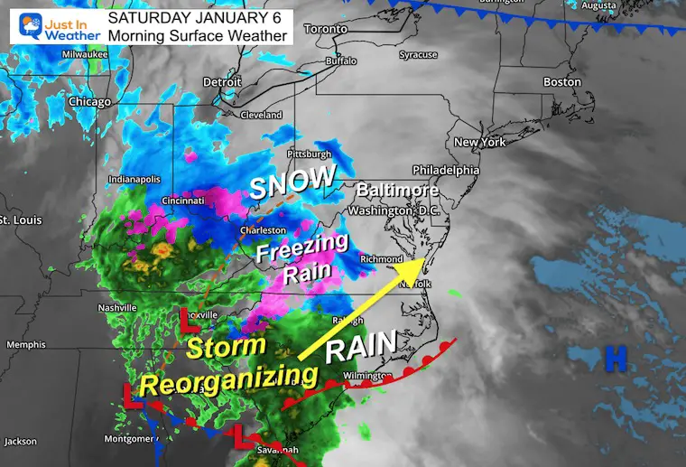
Morning Surface Weather
The initial precipitation will spread in this morning. Often, it shows on radar up to an hour or two before it reaches the ground. But we should be in it before noon for sure!
It may begin with snow and sleet in the cities and areas above freezing, then change to rain. Wet roads are expected along I-95 and south.
Baltimore may get a few hours with sleet and snow mixed, including for Ravens tailgaters, but as it seems now, rain should take over for game time.
The problems will be inland!
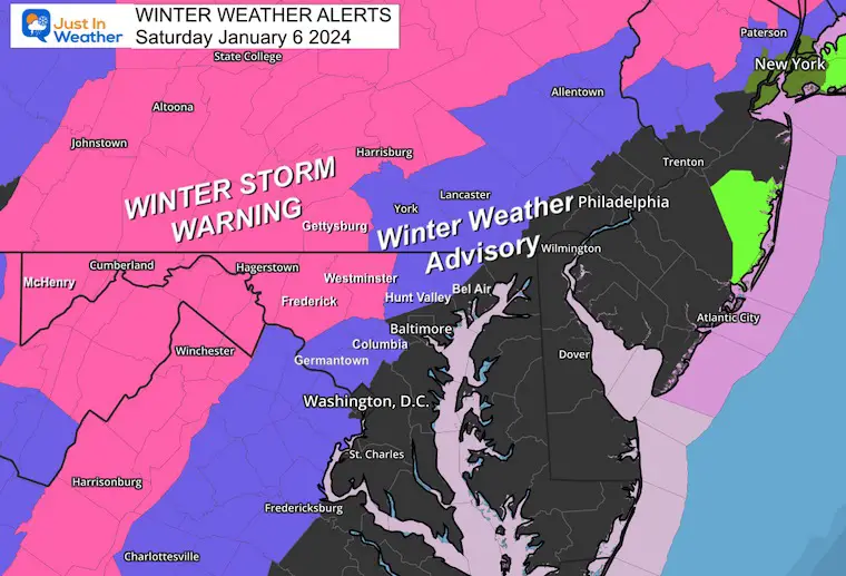
Winter Storm Alerts
Winter Storm Warning:
Maryland: Carroll, Frederick, Washington, and Allegany Counties. Plus, the Skyline Drive area of VA.
3 to 6 inches of snow. Freezing Rain up to 1/4”.
Winter Weather Advisory:
Pennsylvania: 3 to 5 inches (I know this fits more with the ‘Warning,’ but there are different criteria in PA).
Maryland: Northern Harford and Baltimore, Western Howard, and Montgomery Counties. Parts of Central VA: 1 to 3 inches of snow plus a glaze of ice.
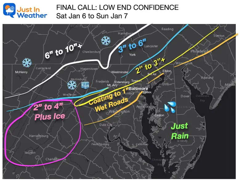
MY MAPS FIRST, MODEL MAPS BELOW
I want to show you my stuff here so you don’t have to dig too deep. The rest of the information is still here, including the timeline maps and 7-day forecast below.
My Final Call Map
Snow Profile Maps
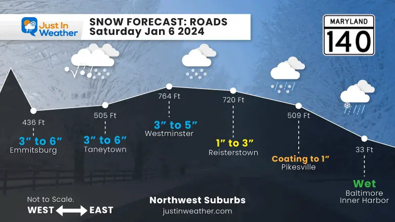
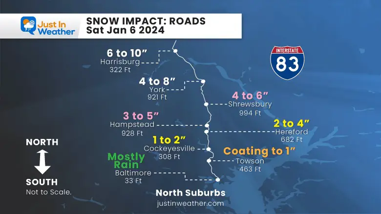
Road Conditions
Maryland I-68 (west) to I-70 (east)
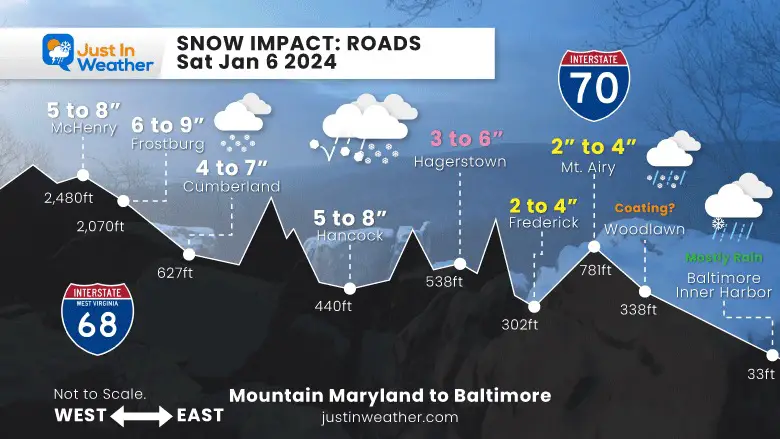
Central Maryland Rt 140
I-83
Baltimore (south) to York and Harrisburg, PA (north)
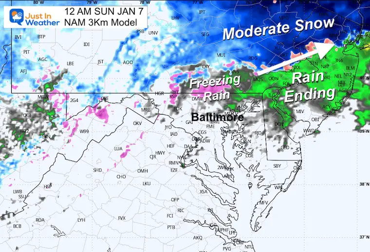
Radar Simulation: NAM 3 Km
10 AM Sat to Midnight
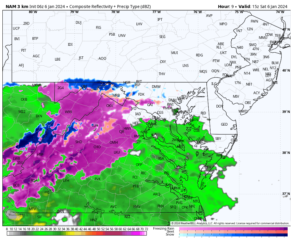
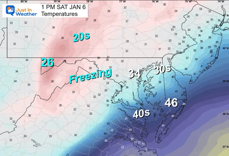
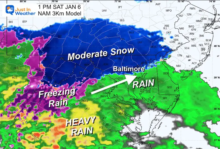
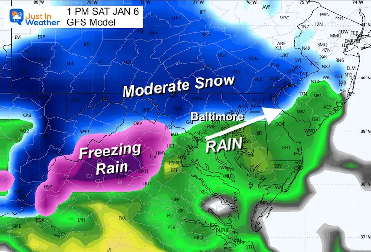
Snapshot at 1 PM
Temperatures
This is critical not only for snow falling but where it is likely to stick versus who gets slush.
This time frame it looks like snow may be falling in metro areas, including Baltimore.
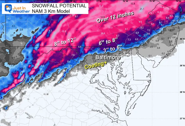
NAM 3 Km
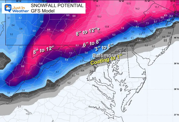
GFS
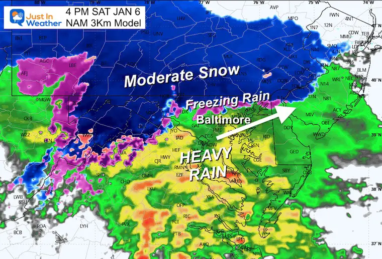
4 PM NAM 3 Km
This is why it looks like rain will take over for the Ravens game, while snow and freezing rain will be found 20 to 30 miles north. Some areas may transition back and forth with a wintry mix for a few hours.
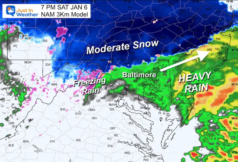
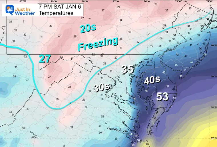
7 PM NAM 3 Km
Rain from Baltimore and along I95. The snow line will be retreating about 30 miles north. Still moderate to heavy snow near and north of the Pennsylvania line.
Temperatures
Midnight
The storm should be out of here by this time. Some light freezing rain or drizzle may linger in the colder northern zones.
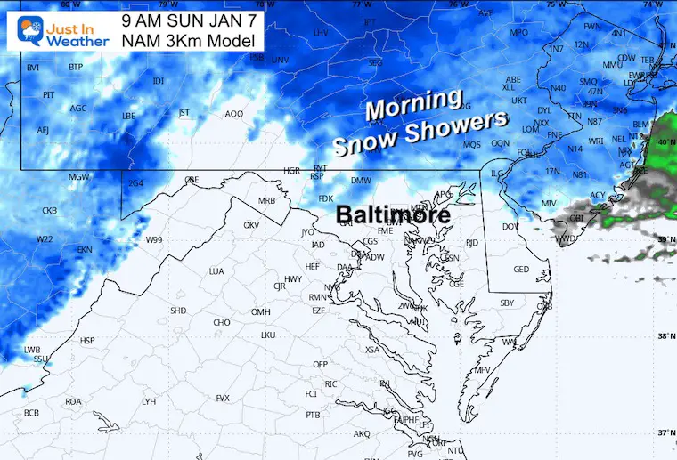
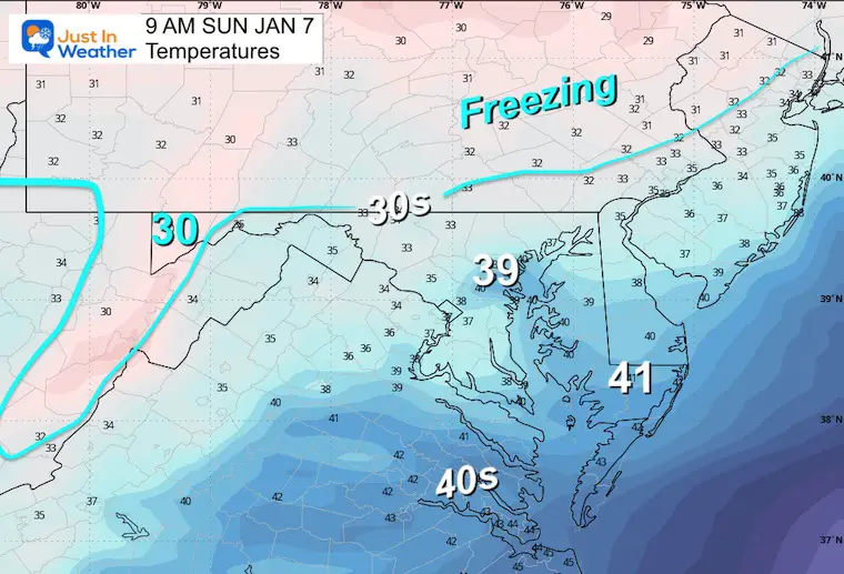
Sunday Morning
Snow Showers
Temperatures
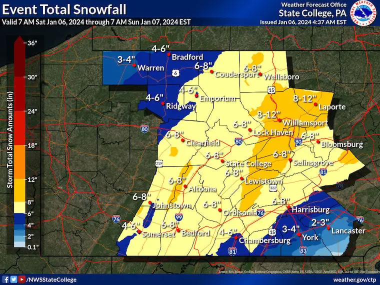
Snow Forecast Maps
NAM 3 Km
GFS Model
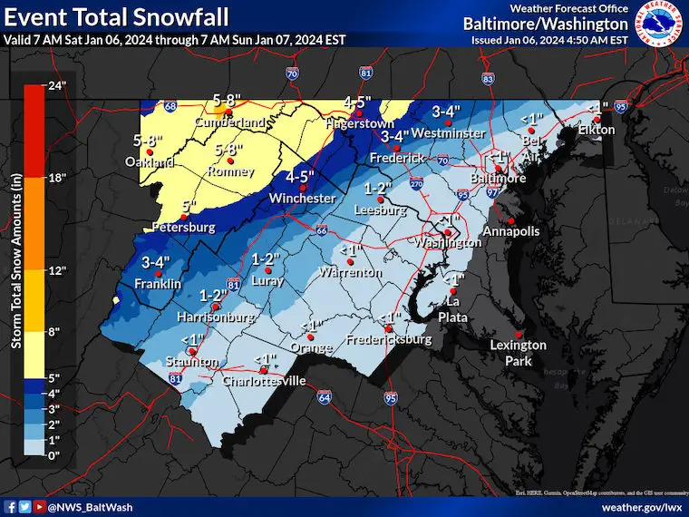
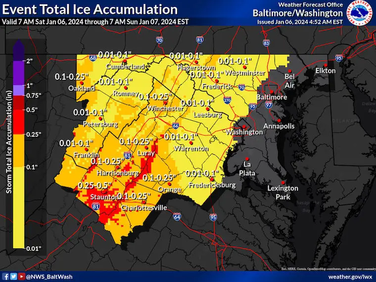
National Weather Service Maps
Snow Maryland/Virginia
Ice Maryland/Virginia
Snow Central Pennsylvania
CLIMATE DATA: Baltimore
TODAY January 6
Sunrise at 7:26 AM
Sunset at 4:59 PM
Normal Low in Baltimore: 26ºF
Record 5ºF in 1904
Normal High in Baltimore: 44ºF
Record 72ºF 1950
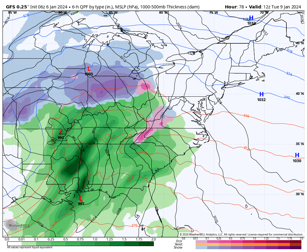
NEXT STORM: Next Tue-Wed
This tracks farther west. Some inland mix, but looks like mostly rain.
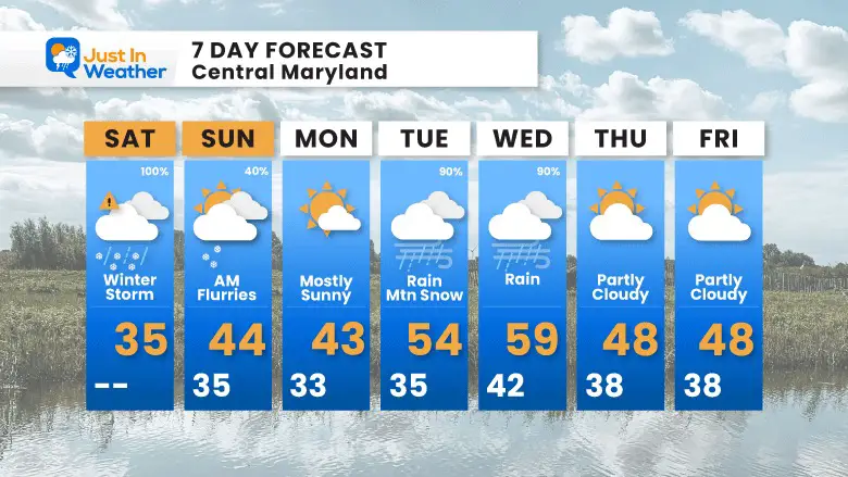
7 Day Forecast
Subscribe for eMail Alerts
RECENT Winter Outlook Reports:

El Niño Winter Updates

Computer Models Support East Coast Storm Track

El Niño Advisory
The latest NOAA report is confident in a Very Strong event. Possibly HISTORIC! This refers to the temperatures in the Pacific, with impacts on the US Winter Storm Track.

Winter Weather Folklore: Top 20 and more signals from nature for snow.
NOAA’s Winter Outlook 2024
Winter Outlook 2024 From Two Farmers Almanacs Return to Cold and Snow
Explore More
Maryland Snow Climate History And Other Winter Pages

Faith in the Flakes Gear

STEM Assemblies/In School Fields Trips Are Back
Click to see more and ‘Book’ a visit to your school

Please share your thoughts and best weather pics/videos, or just keep in touch via social media
RESTATING MY MESSAGE ABOUT DYSLEXIA
I am aware there are some spelling and grammar typos and occasional other glitches. I take responsibility for my mistakes and even the computer glitches I may miss. I have made a few public statements over the years, but if you are new here, you may have missed it: I have dyslexia and found out during my second year at Cornell University. It didn’t stop me from getting my meteorology degree and being the first to get the AMS CBM in the Baltimore/Washington region. One of my professors told me that I had made it that far without knowing and to not let it be a crutch going forward. That was Mark Wysocki, and he was absolutely correct! I do miss my mistakes in my own proofreading. The autocorrect spell check on my computer sometimes does an injustice to make it worse. I also can make mistakes in forecasting. No one is perfect at predicting the future. All of the maps and information are accurate. The ‘wordy’ stuff can get sticky. There has been no editor who can check my work when I need it and have it ready to send out in a newsworthy timeline. Barbara Werner is a member of the web team that helps me maintain this site. She has taken it upon herself to edit typos when she is available. That could be AFTER you read this. I accept this and perhaps proves what you read is really from me… It’s part of my charm.
#FITF


