Friday Night Update
Jan 5, 2024
The Winter Storm Warning and Advisories have had some adjustments with location and extended timing for Saturday. This storm is still taking form and will be racing through our region a little faster. This may trap some of the morning cold in more places. That will also allow snow to stick and stay longer.
It is also important to note that urban areas near I-95 will struggle to get close to freezing. There is a warming influence from the 42ºF water in the Chesapeake Bay that will make for a very sharp gradient from rain to moderate or even heavy snow.
In this report, I wanted to share my Snow Profile display across the main roads in our region that will be affected by the storm. This has been helpful in showing the elevation increase inland, which is a major factor in why we have sharp snow and rain gradients.
A 30-mile spread may determine rain vs. over 4 inches of snow and ice!
Snow Profile Maps: My Calls….
See the full storm report below..
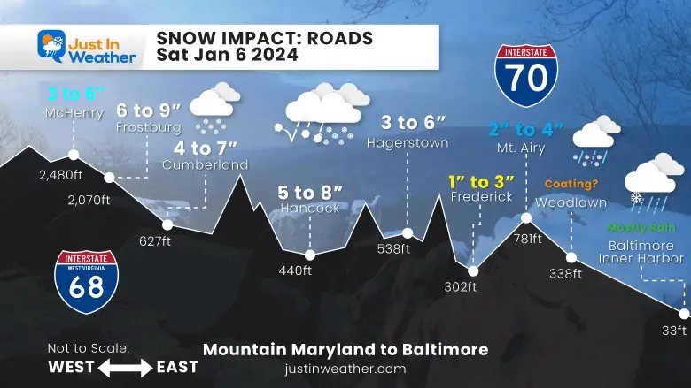
Maryland: Mountains from I-68 to I-70 (Baltimore)
Ironically, the highest snow will NOT be in the highest mountains. Garrett County will be in the 3 to 6-inch range, but I expect the highest totals will fall over Frostburg with up to 9 inches, and slightly lower in the valley of Cumberland.
Hancock and Hagerstown will range with less in the valleys and higher amounts on the mountain passes.
Frederick is in a valley and gets less than the northern part of the county. See below, as Taneytown and Emmitsburg may get 3 to 6 inches of snow.
Mt. Airy will get more than Frederick, then trail off, heading towards the beltway at Woodlawn.
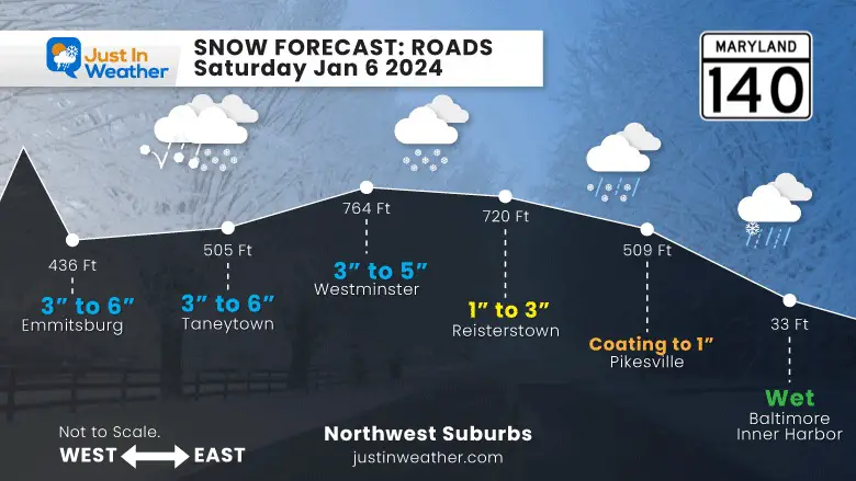
Central Maryland: Rt 140 from Baltimore to Northern Frederick County
This shows the elevation impact above 500 Ft just west of Baltimore. That is where the snow is likely to hold longer! Farther North and West along MD 140, the snow will increase for Westminster, Taneytown, and Emmitsburg.
This may bring close to 6 inches for Ski Liberty Mountain in southern PA as well.
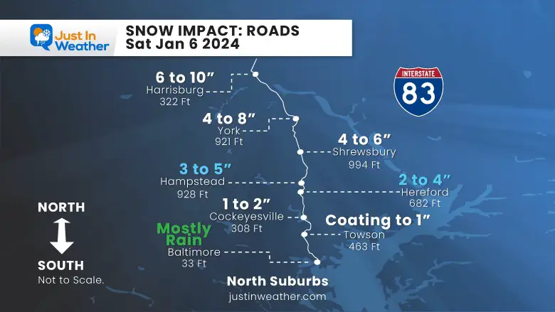
I-83 between Baltimore, MD to Harrisburg, PA
South (bottom) in Baltimore there is little expected with temperatures holding above freezing!
North (up) moves away from the water AND higher in elevation. This is why the Hereford Zone to Southern Pennsylvania gets close to 1,000 Ft in elevation. The snow will increase from being wet in the city to a coating or 1 inch at the beltway, then a few inches to half a foot moving north.
Harrisburg, PA, may stay all or mostly snow, and could bring 6 to 10 inches to Roundtop Mountain as well.
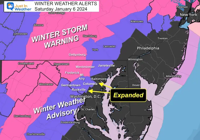
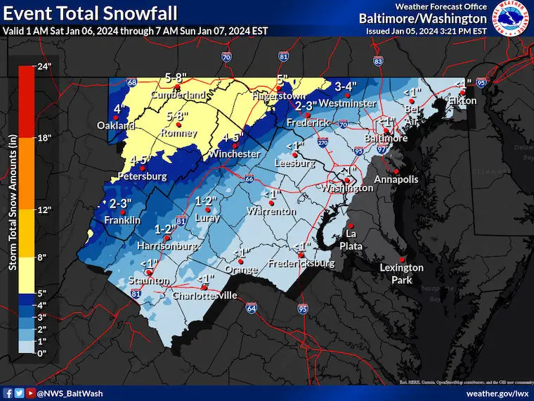
Winter Storm Alerts
Winter Storm Warning:
Maryland: Carroll, Frederick, Washington, and Allegany Counties. Plus, the Skyline Drive area of VA.
3 to 6 inches of snow. Freezing Rain up to 1/4”.
Winter Weather Advisory:
Pennsylvania: 3 to 5 inches (I know this fits more with the ‘Warning’, but there are different criteria in PA).
Maryland: Northern Harford and Baltimore, Western Howard, and Montgomery Counties. Parts of Central VA: 1 to 3 inches of snow plus a glaze of ice.
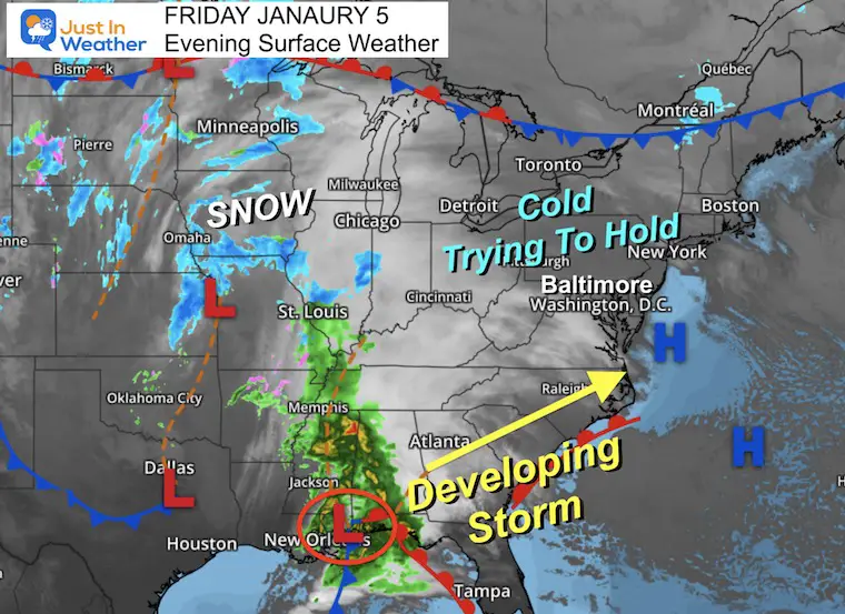
Friday Night Set Up
The cold from today is trying to hold!
The storm taking form along the Gulf Coast east of New Orleans. It has plenty of energy and a contrast of cold and warm, moist air to feed into rapid development.
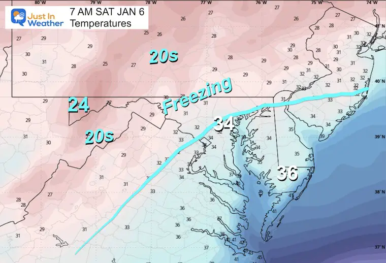
8 PM Friday Temperature Observations
This is intriguing! There are plenty of areas in the 20s this evening, including on Delmarva. This does seem colder than expected for now and is a promising signal if you want more snow.
The wrinkle is that an east wind is expected to develop ahead of the storm, bringing in warmer air from the Atlantic and Chesapeake. I will be taking a first look at these numbers in the morning to see if there needs to be any adjustment for when the snow/rain arrives.
Morning Temps:
Notice the forecast is higher for many areas at sunrise than shown in the observations above.. Hmm???
The thermometer reading when you wake up may help tell your story. If your area is below freezing, you may stay there most of the day.
Some areas will be above freezing and get slushy snow for a bit, but impacts will be minimal to none.
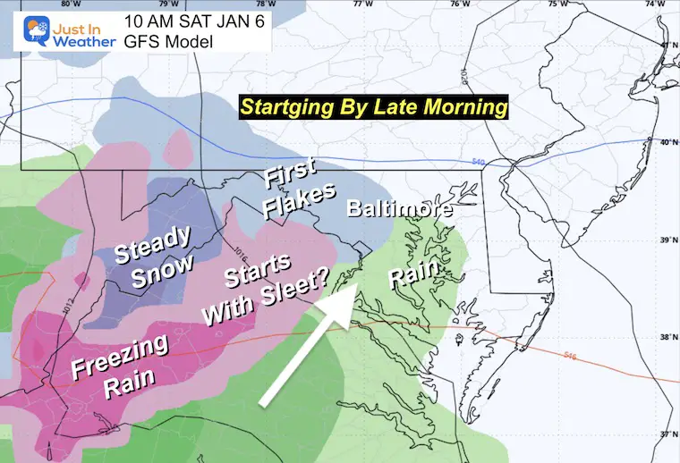
First Flakes
The storm will be moving in during the morning. Metro areas may get the starter flakes or sleet between 10 AM and Noon.
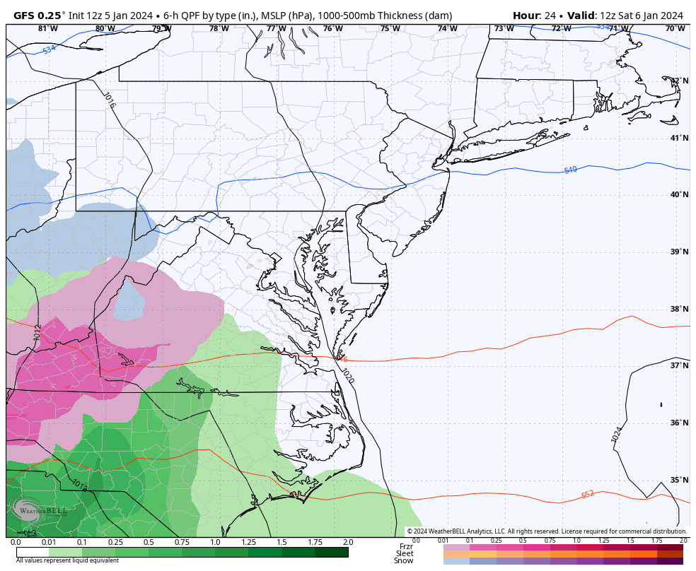
Storm Forecast: Sat AM to Sun Eve
Note: I have been sticking with the GFS for consistency. Its performance is what matches the NWS alerts compared to the warmer/lower snow and ice output from The European Model.
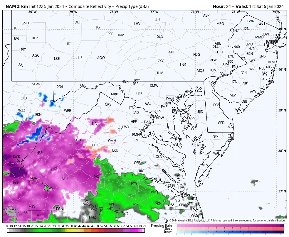
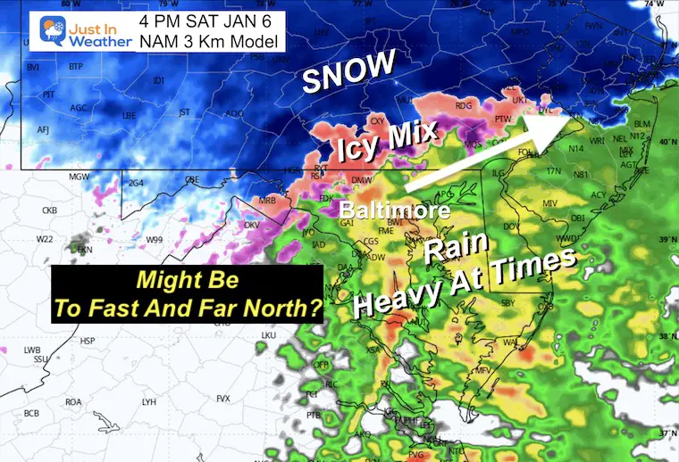
High Resolution NAM 3 Km Model
7 AM Sat to 10 PM Sat
Snapshots Comparing Both Models
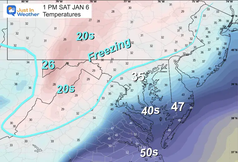
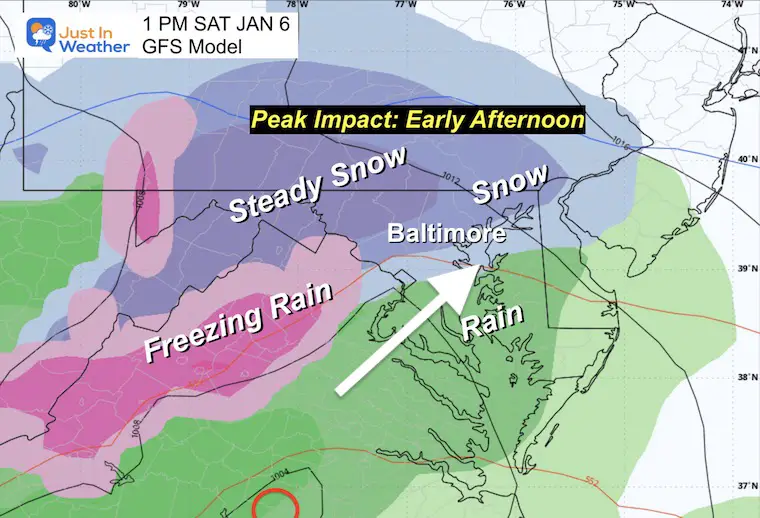
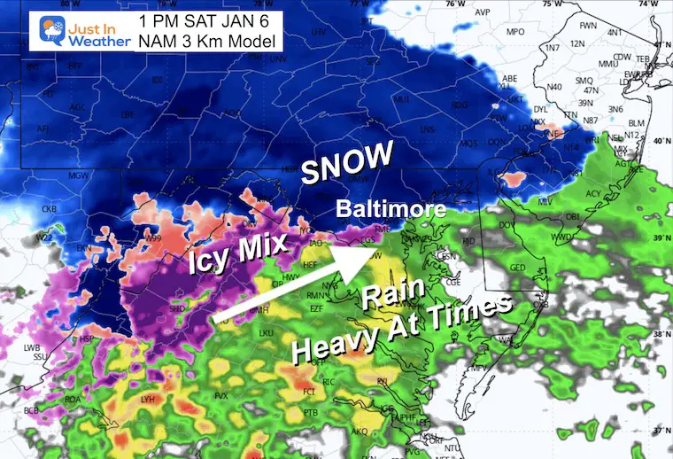
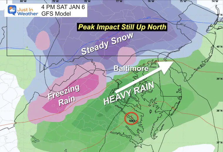
1 PM
The peak impact for many will be during this time. Urban areas may start with up to a couple of hours of snow. It may begin with rain or sleet, then go to snow, then back to rain. Northern areas stay with snow much longer.
Temperatures
This freezing line is critical as it will establish the worst road areas and may hold in these same spots beyond sunset.
The evening transition to freezing rain or rain will be shown below.
GFS
NAM 3 Km
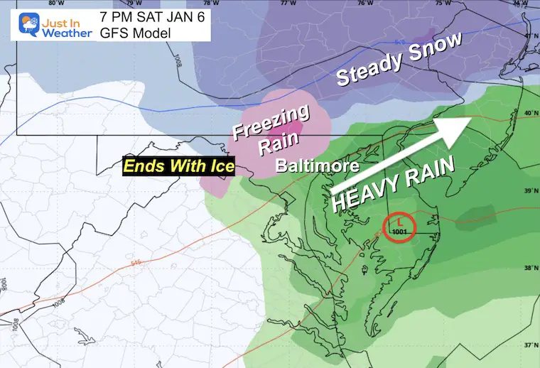
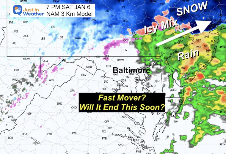
Ravens Game
(After 4:30 pm)
I have been saying it will snow, and I think it will for tailgaters and the start. It looks like a change to rain during the game… If the rain takes over sooner. I will own my mistake.
Snow will continue inland.
GFS holds the cold and snow a little longer.
NAM is much more aggressive with a warmer and stronger storm. This suggests heavy rain and maybe even a rumble of thunder.
Evening
Rain in downtown Baltimore, but traveling home into the Advisory and Warning areas may be challenging!
GFS – Showing an ice event in the Advisory areas north of Baltimore.
NAM – aggressive with the fast movement and bringing this to an end for central Maryland/PA.
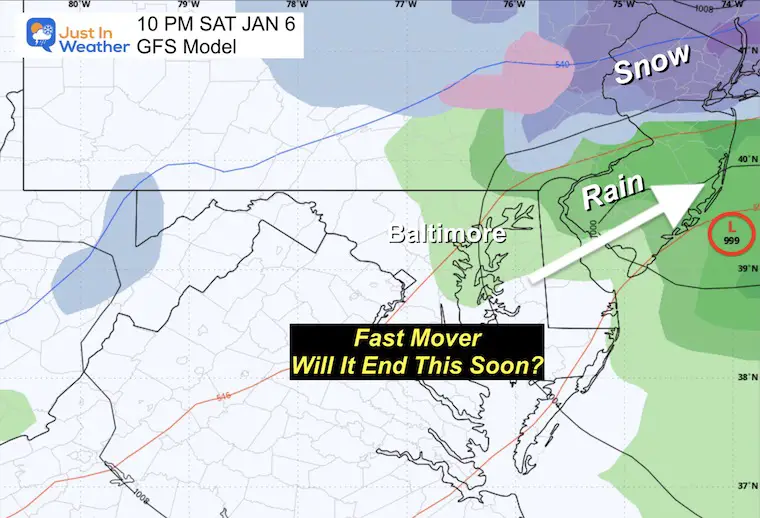
Night
The GFS Model has sped up as well, with the ‘stuff’ ending before midnight.
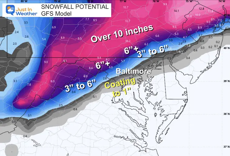
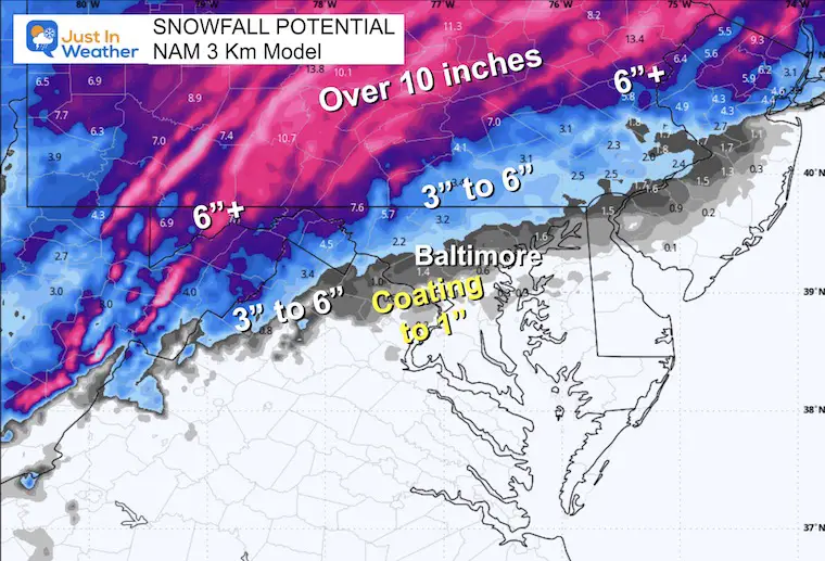
Snow Total Maps
I will make profile maps for I-70 and I-83 in my next report.
GFS
NAM 3 Km
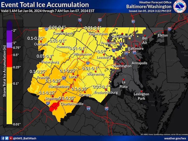
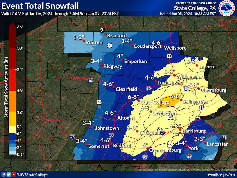
National Weather Service Forecast Maps
Maryland and Virginia
Snow
Ice
Pennsylvania
Subscribe for eMail Alerts
RECENT Winter Outlook Reports:

El Niño Winter Updates

Computer Models Support East Coast Storm Track

El Niño Advisory
The latest NOAA report is confident in a Very Strong event. Possibly HISTORIC! This refers to the temperatures in the Pacific, with impacts on the US Winter Storm Track.

Winter Weather Folklore: Top 20 and more signals from nature for snow.
NOAA’s Winter Outlook 2024
Winter Outlook 2024 From Two Farmers Almanacs Return to Cold and Snow
Explore More
Maryland Snow Climate History And Other Winter Pages

Faith in the Flakes Gear

STEM Assemblies/In School Fields Trips Are Back
Click to see more and ‘Book’ a visit to your school

Please share your thoughts and best weather pics/videos, or just keep in touch via social media
RESTATING MY MESSAGE ABOUT DYSLEXIA
I am aware there are some spelling and grammar typos and occasional other glitches. I take responsibility for my mistakes and even the computer glitches I may miss. I have made a few public statements over the years, but if you are new here, you may have missed it: I have dyslexia and found out during my second year at Cornell University. It didn’t stop me from getting my meteorology degree and being the first to get the AMS CBM in the Baltimore/Washington region. One of my professors told me that I had made it that far without knowing and to not let it be a crutch going forward. That was Mark Wysocki, and he was absolutely correct! I do miss my mistakes in my own proofreading. The autocorrect spell check on my computer sometimes does an injustice to make it worse. I also can make mistakes in forecasting. No one is perfect at predicting the future. All of the maps and information are accurate. The ‘wordy’ stuff can get sticky. There has been no editor who can check my work when I need it and have it ready to send out in a newsworthy timeline. Barbara Werner is a member of the web team that helps me maintain this site. She has taken it upon herself to edit typos when she is available. That could be AFTER you read this. I accept this and perhaps proves what you read is really from me… It’s part of my charm.
#FITF


