


May 19 Weather Sunday Starts Foggy The Warming With Sun And Summer Heat On The Way
Sunday May 19 Morning Report The aftermath of the rainy Saturday is plenty of leftover moisture. This has left us with a bit of humidity and areas of thick fog…
January 4, 2024
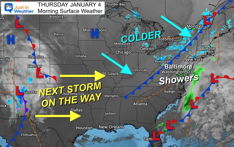
Thursday Morning Update
Today is the day with the split energy I’ve been mentioning. There is a small coastal system to our south and a cold front to the north. In between, there have been some light showers already. We might still see light rain or flurries as the front arrives just for ambiance.
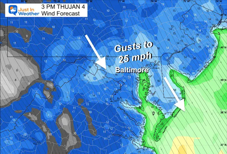
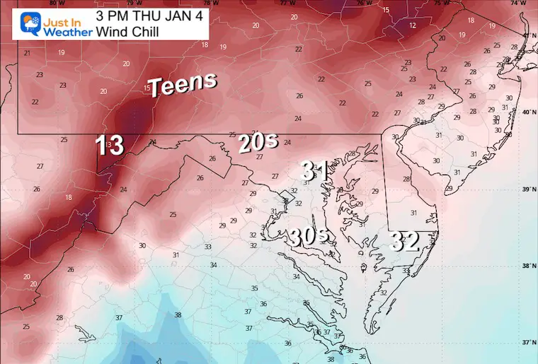
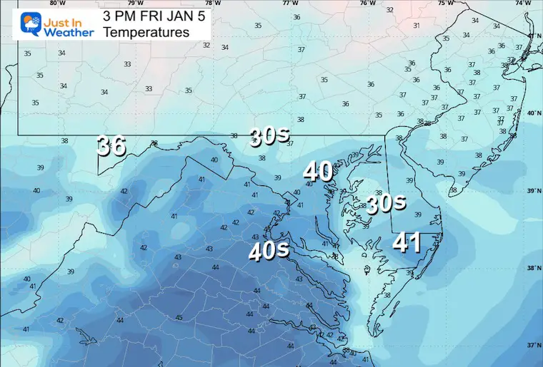
The main story will be about the stronger winds and wind chill as that new air mass arrives.
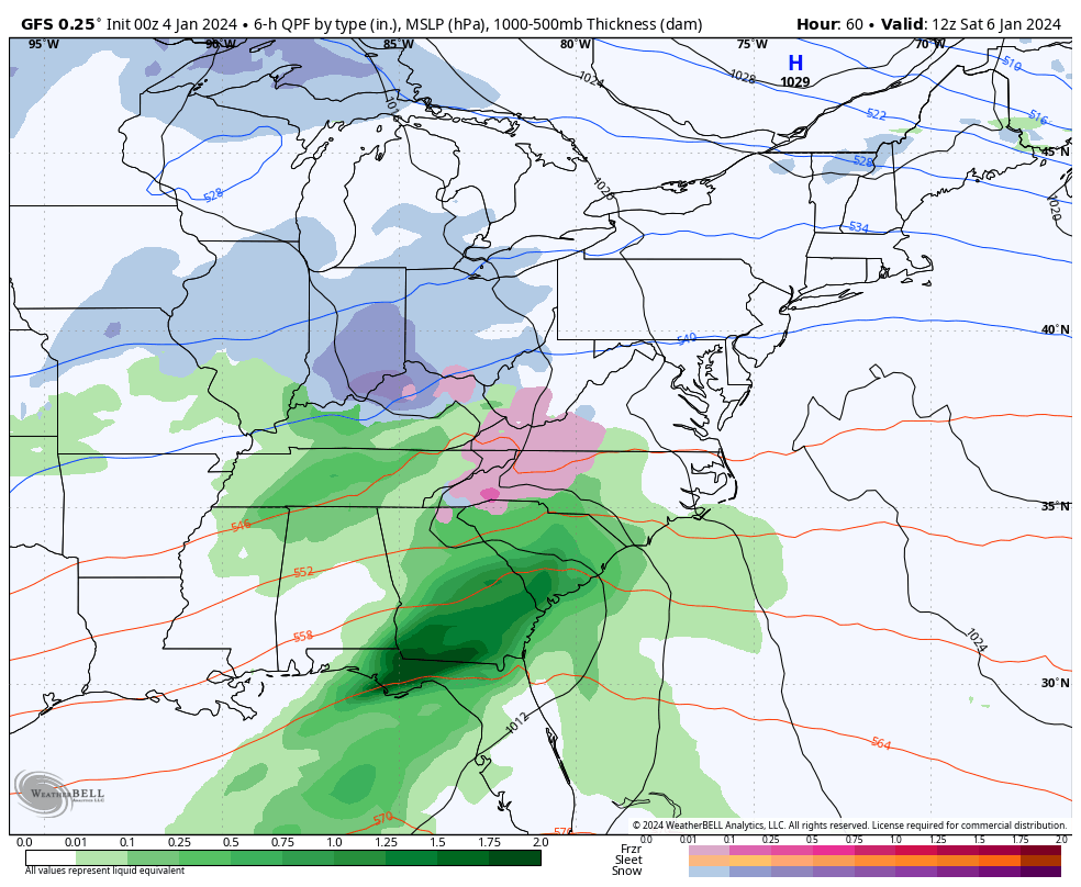
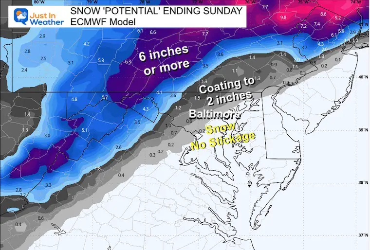
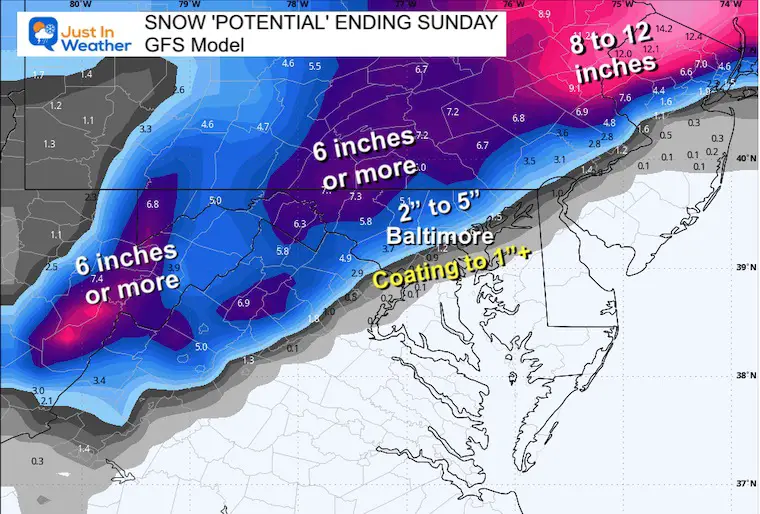
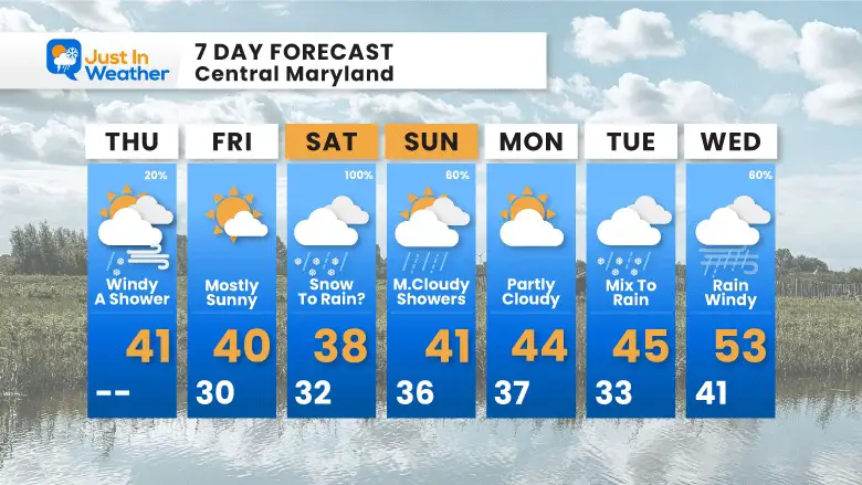
Next up will be the Winter Storm for the weekend. I have been very cautious with the big snow maps, and it appears to be paying off. The storm set up will bring in snow during the middle of the day, but it has been trending a little north and warmer. So, there will be a change over to rain in metro areas while moderate snow will accumulate to the north. Below is a brief look to confirm my in-depth report from last night.
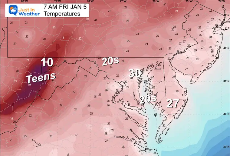
Showers have developed around the Chesapeake Bay and Delmarva. The storm is weak and far away. The cold front inland will need to pass through today. We will notice the winds increase during the afternoon, AND wind chills will be noticeable!
Our next storm is over the Southern Rockies. We will track this to redevelop over the Gulf Coast States tomorrow and reach us on Saturday.
This will NOT show rain vs. snow
Gusts from the Northwest to 25 mph.
Sunrise at 7:26 AM
Sunset at 4:57 PM
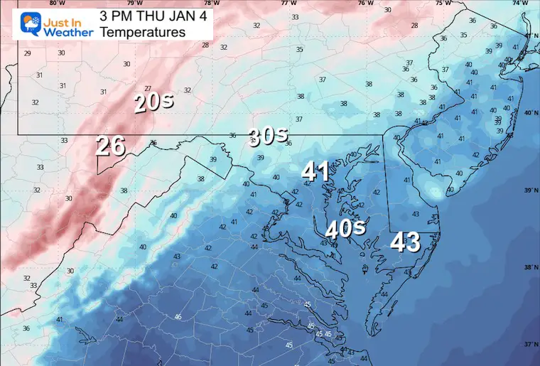
Normal Low in Baltimore: 26ºF
Record 4ºF in 1918
Normal High in Baltimore: 44ºF
Record 70ºF 1950
A sunny and chilly day.
Please note that for simplicity in this morning’s report, I am only using one model. The GFS has performed well and will remain the standard for now. I will compare with other models and give a more detailed analysis in my afternoon and evening reports.
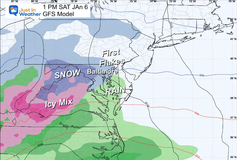
The trend has been to arrive earlier… perhaps as soon as Saturday morning (with the latest solution).
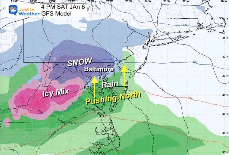
The trend has been to shift the entire setup a little north, as the blocking is not as strong. Steady snow is expected in metro areas right after it begins, even at the Ravens game in Baltimore.
However, given the warmer air with the storm track and considering the influence of the 42ºF Bay water, this will change over to rain in Central Maryland. It might happen by the end of the Ravens game in the evening.
Temps will remain above freezing in metro areas… so the snow that falls may still mean wet roads and limited stickage on the grass.
Farther inland will remain colder and snowy where accumulation will be higher.
Snow will reach into metro areas by lunchtime. Steady snow and even ice will be falling across the mountains. Rain to the south.
4 PM
It still looks like steady snow could be falling over Baltimore for the Ravens game. The rain line will be creeping in from the south but may hold away from the city for a few hours to allow for some accumulation. There will be heavy snow where it remains cold farther inland.
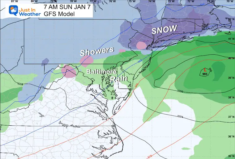
Lingering Showers into the afternoon.
Snow to the north (little to no accumulation).
Rain showers south.
This is the map I posted yesterday.
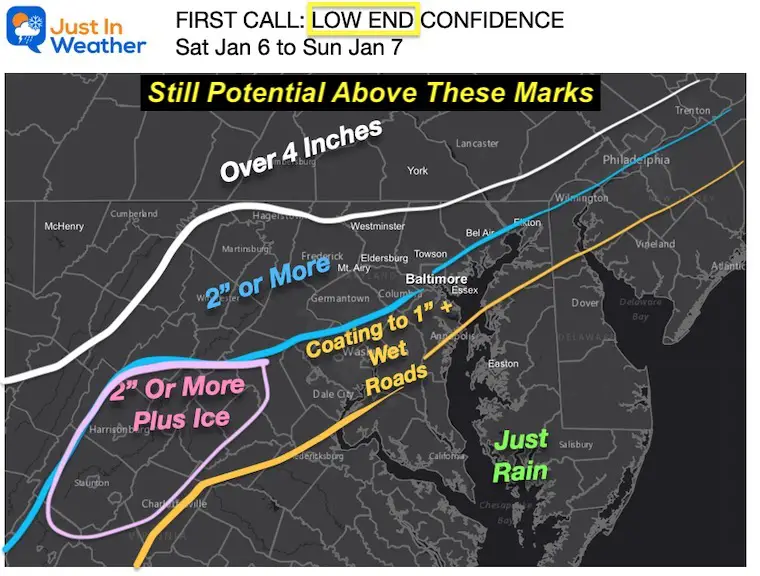
They have trended north/warmer…
The lower snow solution.
Still holding onto the higher totals.
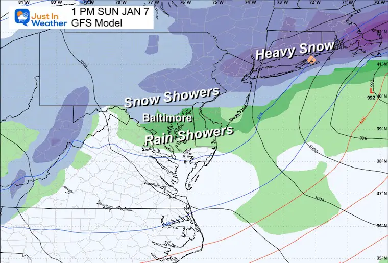
Quick look beyond the weekend storm, and the next one that will follow will be farther west. That means even if it starts with a mix, it is likely to turn to rain.


Computer Models Support East Coast Storm Track

The latest NOAA report is confident in a Very Strong event. Possibly HISTORIC! This refers to the temperatures in the Pacific, with impacts on the US Winter Storm Track.

Winter Weather Folklore: Top 20 and more signals from nature for snow.
Winter Outlook 2024 From Two Farmers Almanacs Return to Cold and Snow


Click to see more and ‘Book’ a visit to your school

I am aware there are some spelling and grammar typos and occasional other glitches. I take responsibility for my mistakes and even the computer glitches I may miss. I have made a few public statements over the years, but if you are new here, you may have missed it: I have dyslexia and found out during my second year at Cornell University. It didn’t stop me from getting my meteorology degree and being the first to get the AMS CBM in the Baltimore/Washington region. One of my professors told me that I had made it that far without knowing and to not let it be a crutch going forward. That was Mark Wysocki, and he was absolutely correct! I do miss my mistakes in my own proofreading. The autocorrect spell check on my computer sometimes does an injustice to make it worse. I also can make mistakes in forecasting. No one is perfect at predicting the future. All of the maps and information are accurate. The ‘wordy’ stuff can get sticky. There has been no editor who can check my work when I need it and have it ready to send out in a newsworthy timeline. Barbara Werner is a member of the web team that helps me maintain this site. She has taken it upon herself to edit typos when she is available. That could be AFTER you read this. I accept this and perhaps proves what you read is really from me… It’s part of my charm.
#FITF