January 4, 2024
Thursday Night Update
As we get closer to this storm there are two things coming into better focus. First, the places that stay below freezing will get a decent snowstorm. Second, the metro areas will be on the edge of accumulation. I keep saying temperatures are critical, and the cities are likely to remain above freezing. So it will snow as it begins, but roads and some ground surfaces may remain wet or slushy.
The cities will have a sharp gradient, with snow sticking on the colder west and north sides of Washington, Baltimore, and Philadelphia.
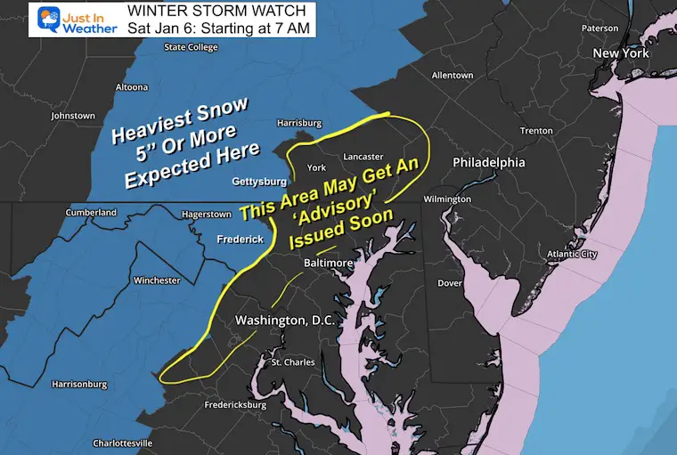
Farther inland, where it will remain cold for longer and over 5 inches of snow are possible, Winter Storm Watches have been issued now that we are less than 48 hours away. Many of these areas will be upgraded to a Warning if the forecast holds on Friday with a closer time frame.
Winter Storm Watch
I’ve added the areas that may get 2 to 4 inches and where a Winter Weather Advisory might be posted on Friday as well.
The set up:
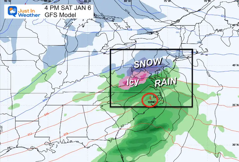
Saturday afternoon, the storm will be in full force across the Mid-Atlantic. This is why I keep mentioning the Ravens home game hosting the Steelers.
A sharp rain line somewhere near or south of I-95 will gradually spread north.
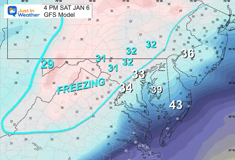
Temperatures
This is KEY!!!! Notice that Baltimore will be around 33ºF and on the edge of the freezing line. That matches up well with the inland areas away from the water and higher in elevation.
That is where some accumulation is likely.
There will be snow in places above freezing. That brings up the challenge of slushy accumulation just on the grass with wet roads… or perhaps some brief slush when the snow falls in heavy bursts.
Storm Animation
GFS Saturday Morning to Sunday Evening
This still looks like a Saturday event, with the added upper-level support back in with some lingering showers into Sunday afternoon.
Let’s Compare:
GFS Model (colder) to the European ECMWF Model (warmer)
Which one is better? To be honest, I think something in between both of these. That is why I am showing them with the expectation in the middle.
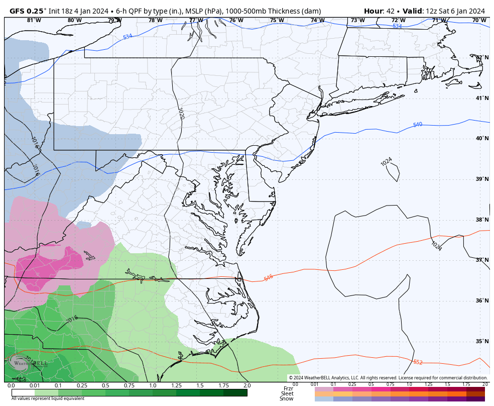
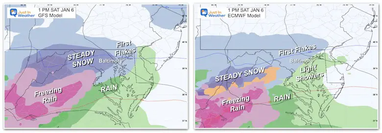
Saturday
1 PM – First flakes into central Maryland by this time.
GFS is stronger with heavier snow and colder air.
ECMWF is light with the rain line along I-95 through Washington and Baltimore.
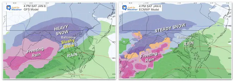
4 PM – Ravens Game Snow
GFS is showing heavy snow over Baltimore.
ECMWF remains with light snow with the rain line along I-95 through Washington and Baltimore.
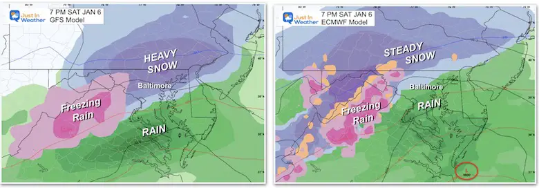
Evening 7 PM
GFS is still showing moderate snow over Baltimore and north.
ECMWF brings the rain line north of Washington and Baltimore.
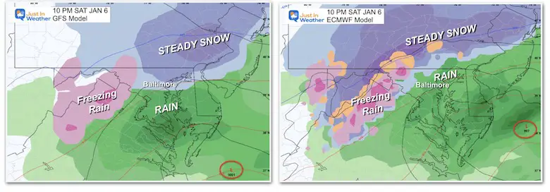
Saturday Night
10 PM
GFS is still showing light snow over Baltimore, with moderate snow NORTH of the city into PA.
ECMWF brings the rain up near the PA line.
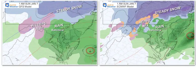
1 AM Sunday
GFS brings the rain up to York, PA, with steady snow into the central PA mountains.
ECMWF actually shows a little wrap-around colder air and tries to bring the snow back down into north central Maryland.
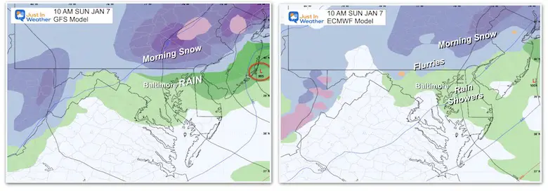
Sunday Morning
GFS has light snow lingering back in Northern Maryland, with a burst of steady snow and additional accumulation for York and Lancaster, PA.
ECMWF keeps rain showers for Baltimore, with light snow showers for the northern suburbs.
The risk of showers may remain into the afternoon as the storm continues to pull away.
Snow Forecast Maps
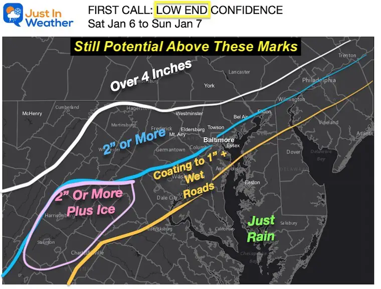
Sticking with my LOW END Confidence Number
This is the minimum I expect, with the potential for higher… I am still playing conservative in central Maryland.
The PA and Maryland Mountain areas are likely to see 4 to 8 inches.
WHAT ARE THEY SAYING?
Compare computer model maps and The National Weather Service local offices.
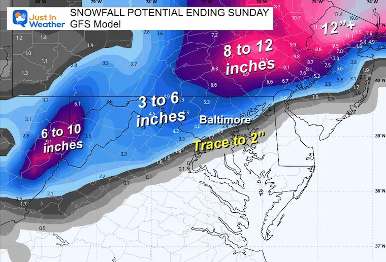
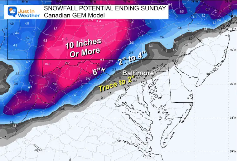
Computer Model Maps
From Lowest To Highest
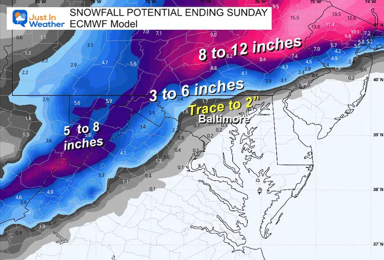
European ECMWF
American GFS Model
Canadian GEM Model
This was the overblown product yesterday, it has since pushed north and in line.
Notice the dramatic gradient from 2 inches to the 10-inch plus range!
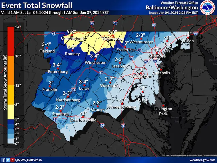
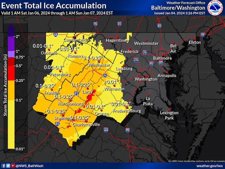
National Weather Service Maps
Click here to view all of the available maps.
NWS- Sterling VA
Snowfall Expectation
Ice Expectation
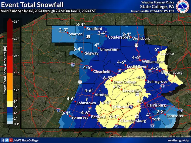
NWS – State College PA
Snowfall Expectation
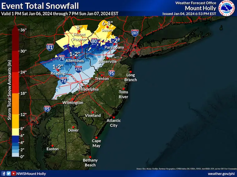
NWS – Mount Holly, NJ
Snowfall Expectation
Notes/Reminders:
Temperatures will be key! Any change closer to or below freezing may impact the ability for stickage or accumulation. Any warmer, and the totals cut off!
Winter Storm Watches will get upgraded to Warnings on Friday for areas that continue to expect over 4 inches of snow.
Winter Weather Advisories will be issued for areas that expect 2 to 4 inches of snow (1 to 3 in any metro areas).
Subscribe for eMail Alerts
RECENT Winter Outlook Reports:

El Niño Winter Updates

Computer Models Support East Coast Storm Track

El Niño Advisory
The latest NOAA report is confident in a Very Strong event. Possibly HISTORIC! This refers to the temperatures in the Pacific, with impacts on the US Winter Storm Track.

Winter Weather Folklore: Top 20 and more signals from nature for snow.
NOAA’s Winter Outlook 2024
Winter Outlook 2024 From Two Farmers Almanacs Return to Cold and Snow
Explore More
Maryland Snow Climate History And Other Winter Pages

Faith in the Flakes Gear

STEM Assemblies/In School Fields Trips Are Back
Click to see more and ‘Book’ a visit to your school

Please share your thoughts and best weather pics/videos, or just keep in touch via social media
RESTATING MY MESSAGE ABOUT DYSLEXIA
I am aware there are some spelling and grammar typos and occasional other glitches. I take responsibility for my mistakes and even the computer glitches I may miss. I have made a few public statements over the years, but if you are new here, you may have missed it: I have dyslexia and found out during my second year at Cornell University. It didn’t stop me from getting my meteorology degree and being the first to get the AMS CBM in the Baltimore/Washington region. One of my professors told me that I had made it that far without knowing and to not let it be a crutch going forward. That was Mark Wysocki, and he was absolutely correct! I do miss my mistakes in my own proofreading. The autocorrect spell check on my computer sometimes does an injustice to make it worse. I also can make mistakes in forecasting. No one is perfect at predicting the future. All of the maps and information are accurate. The ‘wordy’ stuff can get sticky. There has been no editor who can check my work when I need it and have it ready to send out in a newsworthy timeline. Barbara Werner is a member of the web team that helps me maintain this site. She has taken it upon herself to edit typos when she is available. That could be AFTER you read this. I accept this and perhaps proves what you read is really from me… It’s part of my charm.
#FITF


