


May 19 Weather Sunday Starts Foggy The Warming With Sun And Summer Heat On The Way
Sunday May 19 Morning Report The aftermath of the rainy Saturday is plenty of leftover moisture. This has left us with a bit of humidity and areas of thick fog…
January 3, 2024
Wednesday Night Update
We are now under the 72-hour mark from the start of the winter event this Saturday, and it’s time to get a handle on the totals. Temperatures on the ground with snow falling AND any change over will play big roles in the final results.
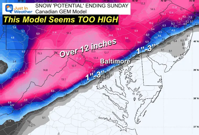
If you have been following my forecasts and comparing them to other outlets, that’s good. I think everyone should have more than one source of information. However, I follow a prudent approach with snow events because there is way too much variability and often inflated expectations that get let down as we get closer. There are occasions where things ramp up as we get closer, but in my decades of experience and obsession with snow, it’s best to start low.
In this report, I will show my map of low-end confidence numbers. This is the minimum expected with the potential to go higher.
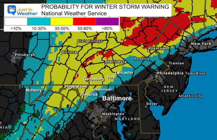
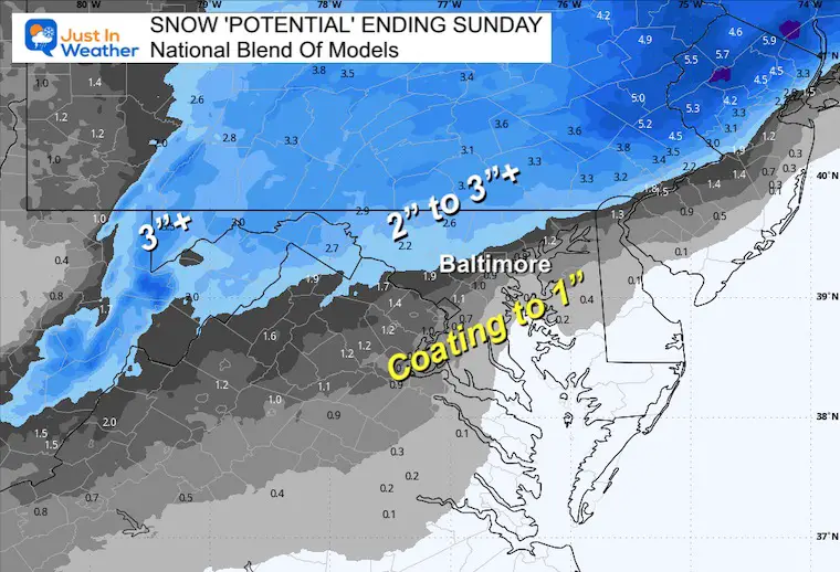
Given that 5 inches of expected snow would trigger The National Weather Service to issue a Winter Storm Warning, here is a new product showing the chances for that as it is seen now:
We only reach the 50% mark in Northern Carroll, Frederick, and Washington Counties in Maryland into Southern PA.
This is based on all snow falling in those same zones… The rest will be determined by what can stick with marginal temps and also when there may be a change over to rain.
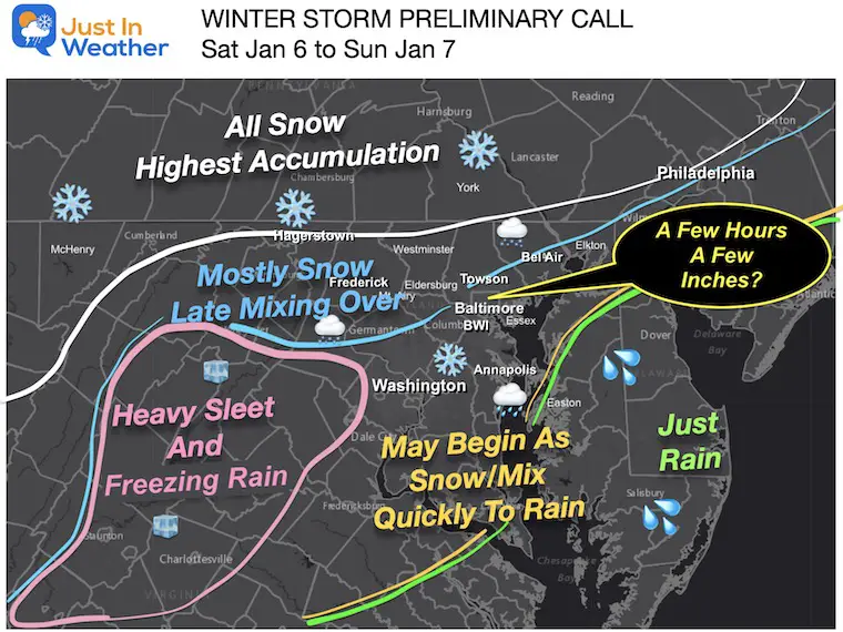
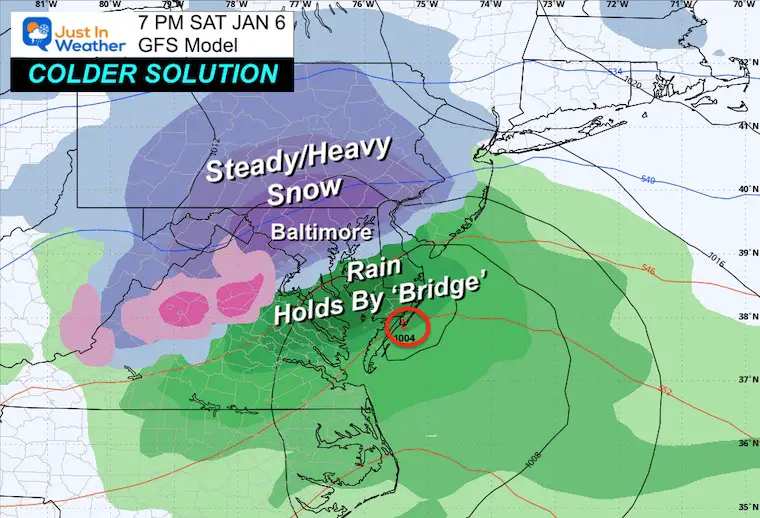
Saturday evening, there will be snow in place with a sharp rain line somewhere near I-95 across the Mid-Atlantic.
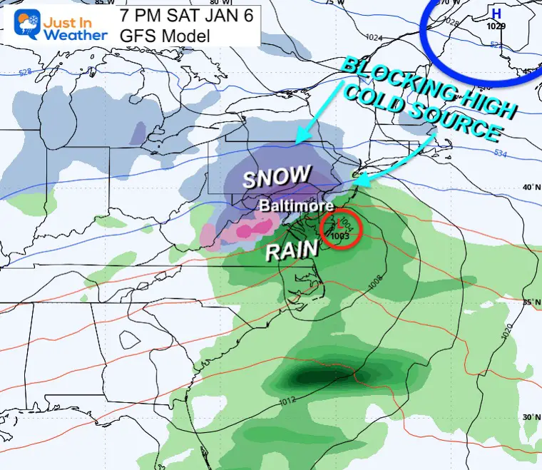
High Pressure in Maine will be the source of cold air and the block to direct the storm track. The question up for debate is how cold and where will that set up to hold.
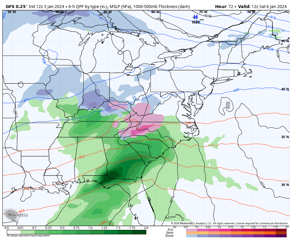
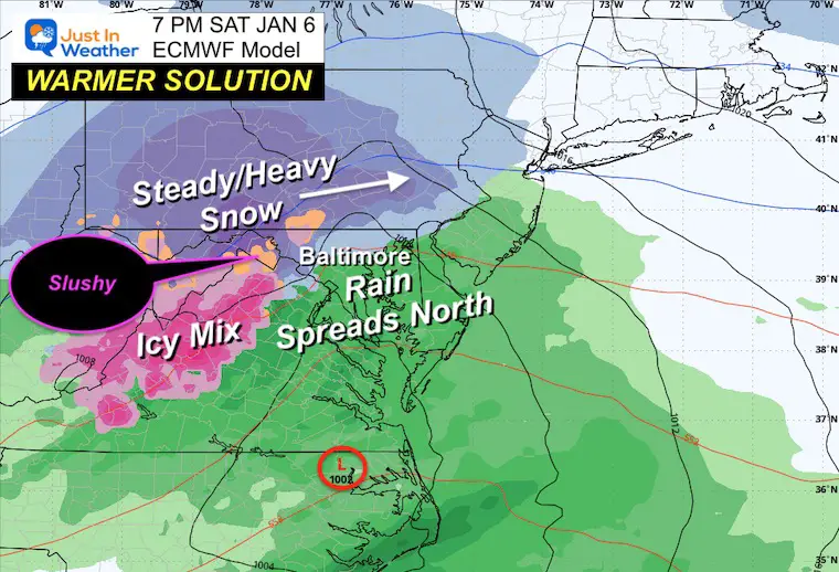
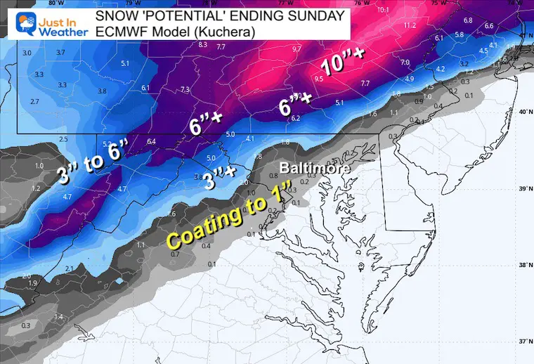
Note: This is the colder solution. I will compare it to the warmer European Model in the snapshots below.
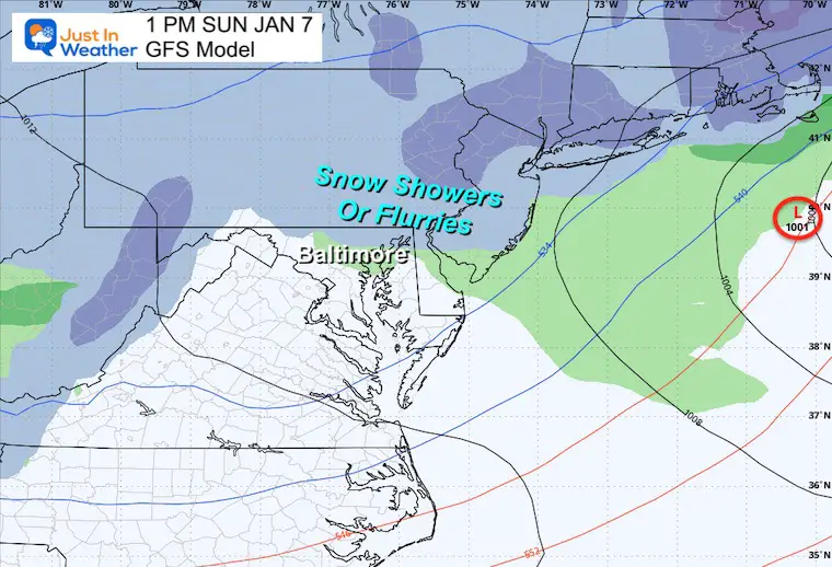
This still looks like a Saturday event, ending Sunday morning. However, some lingering showers may last into Sunday afternoon with little to no local impact. But traveling through New England may still be a problem.
The trend of speeding this system up now brings snow to the mountains in the morning and perhaps entering central Maryland within an hour or two of noon.
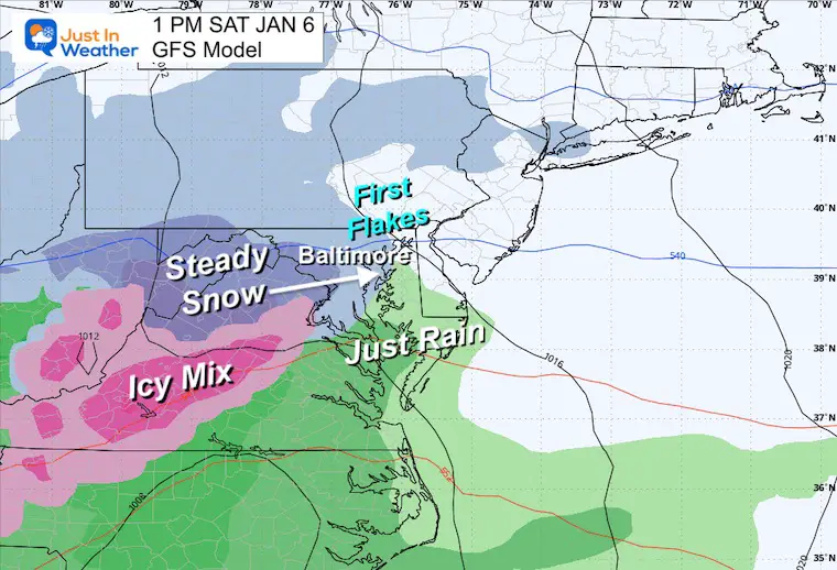
Notice the freezing line sets up WEST of Baltimore and Washington. It can snow from colder clouds with surface temps above freezing.
Also: The water in the Chesapeake Bay is still near 42°F, which will add a source of warming nearby.
If this plays out, the steady snow may be falling by the start of the football game in downtown Baltimore.
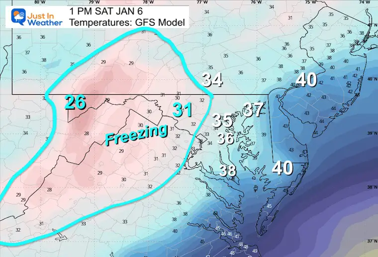
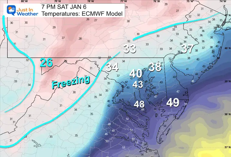
Temperatures:
The surface freezing line is holding west and north of Baltimore. That would render the metro snow competing just for stickage and compaction, let alone accumulation.
Snow Falling: This has it still snowing over Baltimore and even Annapolis. But with temps above freezing the stickage potential will be a factor.
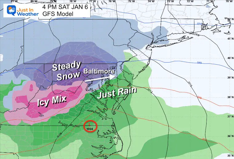
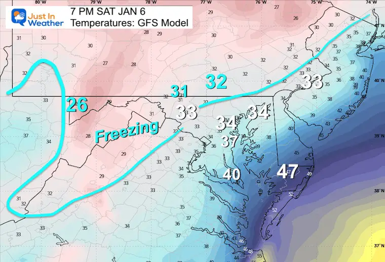
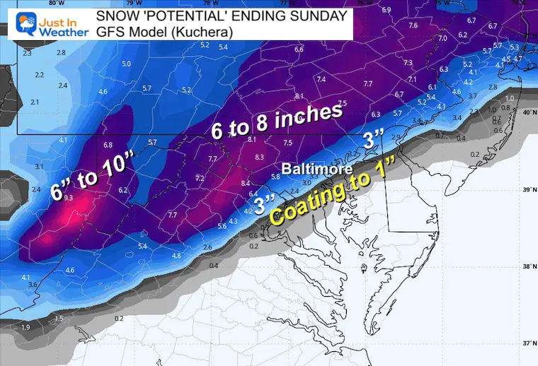
Notice the push of 40s to Baltimore. That is a dramatic difference, thank the GFS and will be on display at the Ravens game. Will it continue to snow or turn to rain by the 4th quarter?
Baltimore is shown in the rain, with the snow line pushed back near the PA line. That would seriously cut off a lot of snow expectations IF THIS PLAYS OUT!
A big IF.
The main storm will be ending; however, showers with snow and flurries may linger into the afternoon while the storm rages across New England. Travel will be affected there… but will have the night to clear out.
This is the minimum I expect, with the potential for higher… I had to account for warm ground and marginal temperatures near or above freezing in metro Baltimore and Washington.
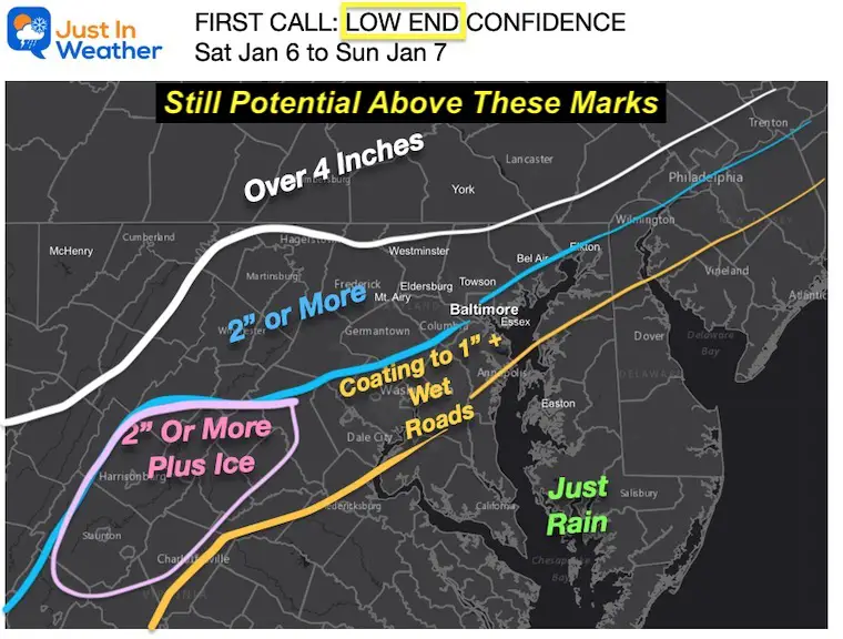
I often toss the highest aside, as this seems like it is blown a bit out of proportion.


Computer Models Support East Coast Storm Track

The latest NOAA report is confident in a Very Strong event. Possibly HISTORIC! This refers to the temperatures in the Pacific, with impacts on the US Winter Storm Track.

Winter Weather Folklore: Top 20 and more signals from nature for snow.
Winter Outlook 2024 From Two Farmers Almanacs Return to Cold and Snow

Click to see more and ‘Book’ a visit to your school

I am aware there are some spelling and grammar typos and occasional other glitches. I take responsibility for my mistakes and even the computer glitches I may miss. I have made a few public statements over the years, but if you are new here, you may have missed it: I have dyslexia and found out during my second year at Cornell University. It didn’t stop me from getting my meteorology degree and being the first to get the AMS CBM in the Baltimore/Washington region. One of my professors told me that I had made it that far without knowing and to not let it be a crutch going forward. That was Mark Wysocki, and he was absolutely correct! I do miss my mistakes in my own proofreading. The autocorrect spell check on my computer sometimes does an injustice to make it worse. I also can make mistakes in forecasting. No one is perfect at predicting the future. All of the maps and information are accurate. The ‘wordy’ stuff can get sticky. There has been no editor who can check my work when I need it and have it ready to send out in a newsworthy timeline. Barbara Werner is a member of the web team that helps me maintain this site. She has taken it upon herself to edit typos when she is available. That could be AFTER you read this. I accept this and perhaps proves what you read is really from me… It’s part of my charm.
#FITF