December 14, 2023
Thursday Morning Update
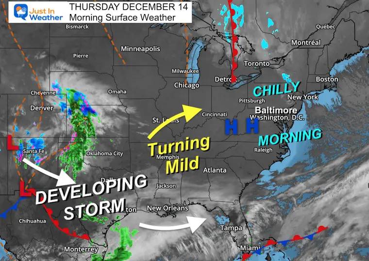
Today, we bottom out with the temperatures and then turn the corner tomorrow with a little warm-up. A new storm is just beginning to develop across the Southern Rockies and Central Plains. This is expected to reorganize in the Gulf of Mexico and spread our way on Sunday.
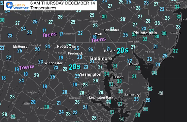
Morning Temperatures
Morning Surface Weather
High-Pressure overhead has brought us a clear sky and a chilly morning. The winds will shift from the southwest tomorrow, warming us up a little. That will allow the developing storm to spread our way later in the weekend.
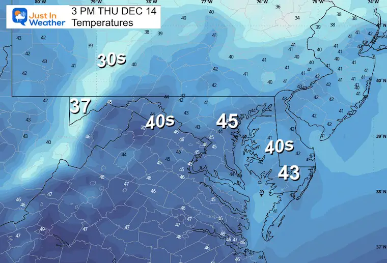
Afternoon Temperatures
CLIMATE DATA: Baltimore
TODAY December 14
Sunrise at 7:17 AM
Sunset at 4:44 PM
Normal Low in Baltimore: 30ºF
Record 11ºF in 1960
Normal High in Baltimore: 48ºF
Record 71ºF 1881, 1929, AND 2015
-Winter Outlook Reports Links below the 7-Day Forecast-
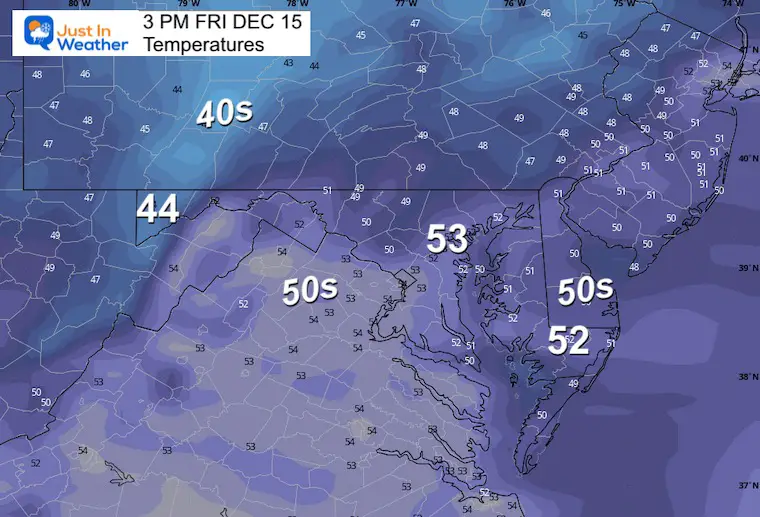
Friday Temperatures
Morning
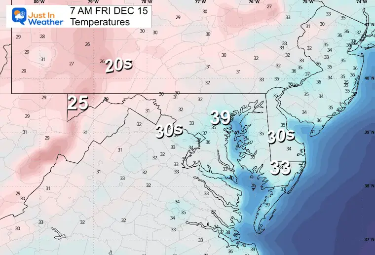
Afternoon
Storm Animation: Saturday Evening to Tuesday Morning
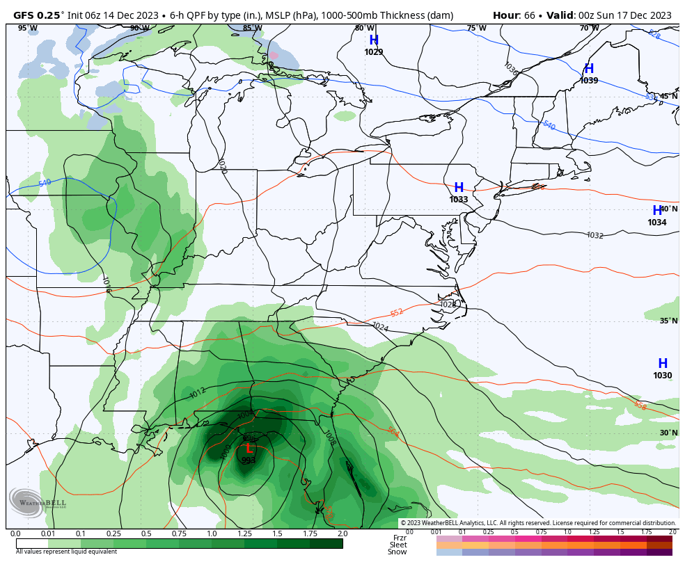
GFS MODEL – This has been the most consistent with the storm track… The European Model has also followed this solution.
The trend I have noticed is a faster arrival. So rain may arrive early in the afternoon and last through the evening and overnight.
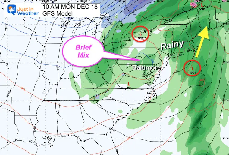
Monday will feature the ambiguous one between the two areas of Low Pressure. This zone will have showers and could include a pocket of cold enough air to bring in a wintry mix (no stickage).
Snapshots
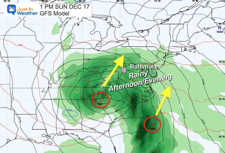
Sunday Afternoon
The Primary Low will be inland, with a secondary Low Pressure on the coast. This will help enhance the moisture in the overall system.
The timing now brings the rain earlier in the afternoon.
Monday Morning
We can identify a pocket of chilly air aloft that may bring a brief mix.. no stickage.
Rain Forecast Potential
A large portion of the Mid-Atlantic can expect over 1 inch of rain. There may be some spots that break the 2-inch mark.

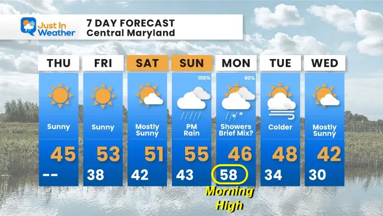
7 Day Forecast
A brief warm-up with the wind shift tomorrow into the weekend.
The storm is expected to bring rain earlier in the afternoon on Sunday and last into Monday with lingering showers. Then the colder air will spill in behind it into the middle of next week.
RECENT Winter Outlook Reports:

El Niño Winter Updates

Computer Models Support East Coast Storm Track

El Niño Advisory
The latest NOAA report is confident in a Very Strong event. Possibly HISTORIC! This refers to the temperatures in the Pacific, with impacts on the US Winter Storm Track.

Winter Weather Folklore: Top 20 and more signals from nature for snow.
NOAA’s Winter Outlook 2024
Winter Outlook 2024 From Two Farmers Almanacs Return to Cold and Snow
Subscribe for eMail Alerts
Explore More
Maryland Snow Climate History And Other Winter Pages

Faith in the Flakes Gear

STEM Assemblies/In School Fields Trips Are Back
Click to see more and ‘Book’ a visit to your school

Subscribe for eMail Alerts
Please share your thoughts and best weather pics/videos, or just keep in touch via social media
RESTATING MY MESSAGE ABOUT DYSLEXIA
I am aware there are some spelling and grammar typos and occasional other glitches. I take responsibility for my mistakes and even the computer glitches I may miss. I have made a few public statements over the years, but if you are new here, you may have missed it: I have dyslexia and found out during my second year at Cornell University. It didn’t stop me from getting my meteorology degree and being the first to get the AMS CBM in the Baltimore/Washington region. One of my professors told me that I had made it that far without knowing and to not let it be a crutch going forward. That was Mark Wysocki, and he was absolutely correct! I do miss my mistakes in my own proofreading. The autocorrect spell check on my computer sometimes does an injustice to make it worse. I also can make mistakes in forecasting. No one is perfect at predicting the future. All of the maps and information are accurate. The ‘wordy’ stuff can get sticky. There has been no editor who can check my work when I need it and have it ready to send out in a newsworthy timeline. Barbara Werner is a member of the web team that helps me maintain this site. She has taken it upon herself to edit typos when she is available. That could be AFTER you read this. I accept this and perhaps proves what you read is really from me… It’s part of my charm.
#FITF


