December 13, 2023
Wednesday Morning Update
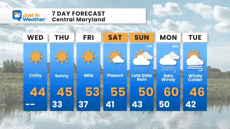
We remain in a chilly pattern for two more days under sunshine. Then, the winds will turn from the South and allow us to warm a little above average to end the week and into the weekend.
The next storm will reach us later on Sunday. We will watch it develop in the Gulf of Mexico and then expand up the East Coast.
There are two different solutions I will show below, comparing the GFS to the European Models. They start the same with rain Sunday evening into Monday. What follows into next week is very different.
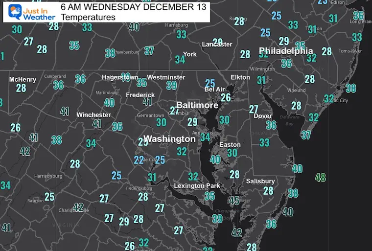
Morning Temperatures
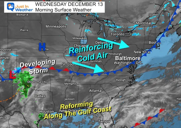
Morning Surface Weather
A quiet cold front is reinforcing the colder air with a new Canadian Air Mass. This is also helping to direct the next storm to the south…. That will redevelop a larger storm in the Gulf of Mexico by the weekend… which will then spread up the coast for us by Sunday.
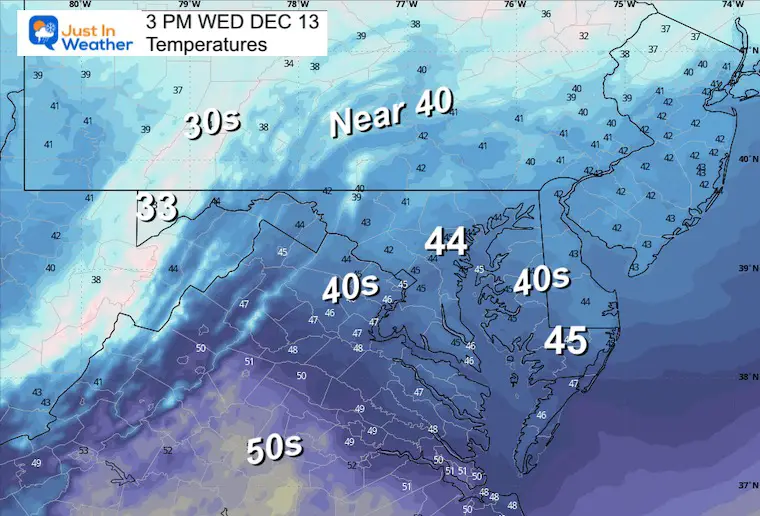
Afternoon Temperatures
CLIMATE DATA: Baltimore
TODAY December 13
Sunrise at 7:17 AM
Sunset at 4:44 PM
Normal Low in Baltimore: 30ºF
Record 8ºF in 1960
Normal High in Baltimore: 48ºF
Record 72ºF 2015
– Winter Outlook Reports Links below the 7-Day Forecast –
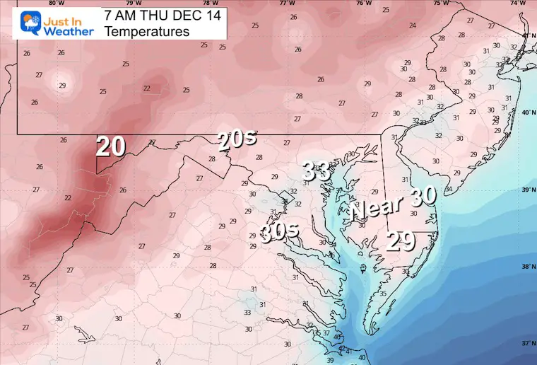
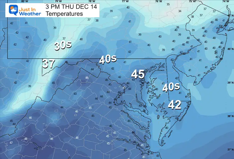
Thursday Temperatures
We will remain sunny and dry into the weekend.
Morning
Afternoon
Storm Animation: Sunday Morning to Wednesday
GFS MODEL
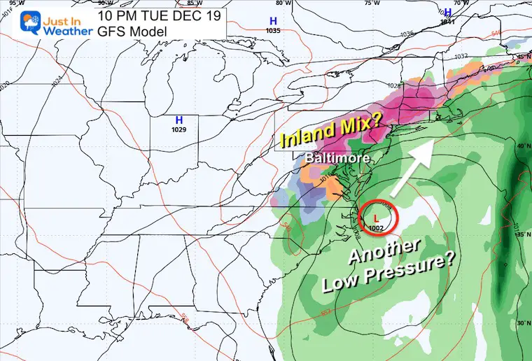
This is an interesting setup. Low Pressure develops in the Gulf of Mexico and expands to the East Coast.
What this model is trying to do is close off an Upper-Level Low in the Jet Stream. That would result in additional areas of Low Pressure, keeping the rain in place for a few more days. It also ‘suggests’ the influence of colder air to result in an icy mix Tuesday night.
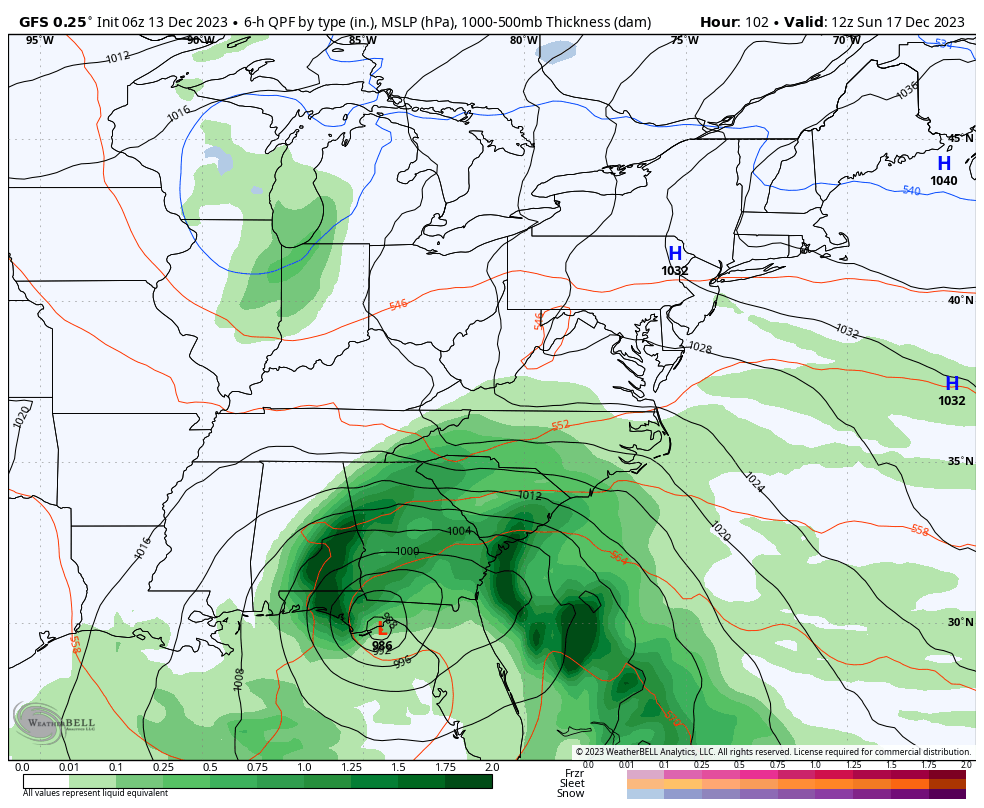
Snapshots
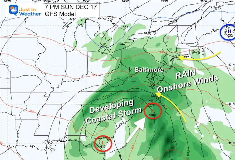
Sunday Evening
Two areas of Low Pressure appear to be part of this storm complex, developing from The Gulf of Mexico and extending up the Atlantic Coast.
The winds from the East will increase the moisture. Rain will be developing during the afternoon and evening.
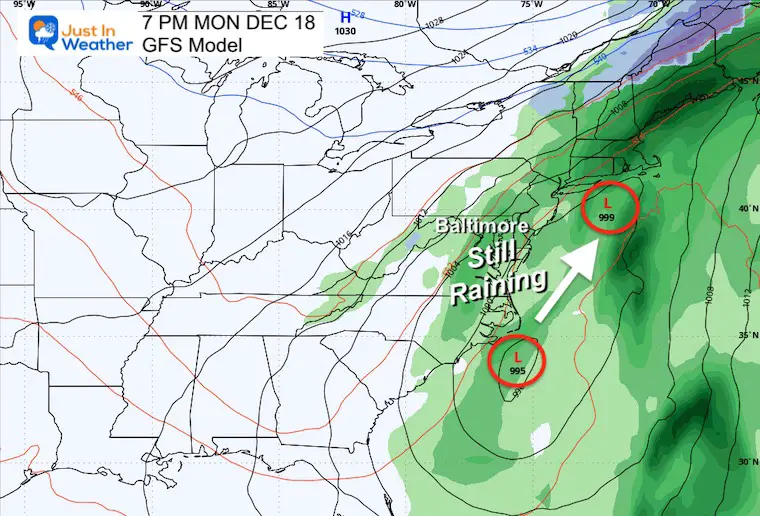
Monday Evening
The bulk of this coastal storm will bring a full day of heavy rain and gusty winds (Nor’easter).
Tuesday Night
This is the part I am questioning, but still wanted to show you. Additional waves of Low Pressure pull in colder air and, as ‘suggested’ here, may expand a wintry/icy mix.
Compare the European Model below with a very different solution.
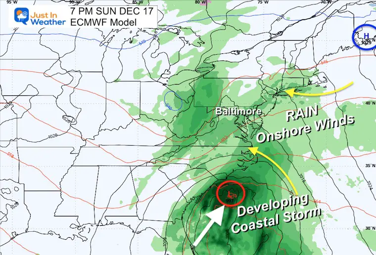
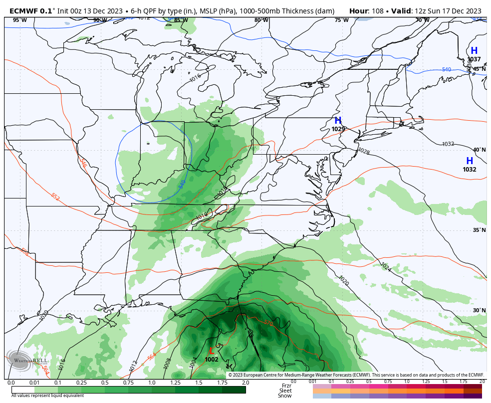
ECMWF MODEL
Sunday Night
This looks very similar to the GFS Model. The storm will develop with two areas of low pressure that will move up the coast. The winds from the East will increase the moisture and result in rain later in the day and overnight.
Storm Animation: Sunday Morning to Tuesday
This is a similar solution. One storm moving through, followed by colder/drier winds by Tuesday. The European Model does not close off the upper low to linger.
7 Day Forecast
Two more chilly days, then turning more mild to end the week and into the next storm.
Rain should arrive later on Sunday. The main event with heavy rain and wind appears to be on Monday. The follow-up storm (GFS model) is still uncertain.
RECENT Winter Outlook Reports:

El Niño Winter Updates

Computer Models Support East Coast Storm Track

El Niño Advisory
The latest NOAA report is confident in a Very Strong event. Possibly HISTORIC! This refers to the temperatures in the Pacific, with impacts on the US Winter Storm Track.

Winter Weather Folklore: Top 20 and more signals from nature for snow.
NOAA’s Winter Outlook 2024
Winter Outlook 2024 From Two Farmers Almanacs Return to Cold and Snow
Subscribe for eMail Alerts
Explore More
Maryland Snow Climate History And Other Winter Pages

Faith in the Flakes Gear

STEM Assemblies/In School Fields Trips Are Back
Click to see more and ‘Book’ a visit to your school

Subscribe for eMail Alerts
Please share your thoughts and best weather pics/videos, or just keep in touch via social media
RESTATING MY MESSAGE ABOUT DYSLEXIA
I am aware there are some spelling and grammar typos and occasional other glitches. I take responsibility for my mistakes and even the computer glitches I may miss. I have made a few public statements over the years, but if you are new here, you may have missed it: I have dyslexia and found out during my second year at Cornell University. It didn’t stop me from getting my meteorology degree and being the first to get the AMS CBM in the Baltimore/Washington region. One of my professors told me that I had made it that far without knowing and to not let it be a crutch going forward. That was Mark Wysocki, and he was absolutely correct! I do miss my mistakes in my own proofreading. The autocorrect spell check on my computer sometimes does an injustice to make it worse. I also can make mistakes in forecasting. No one is perfect at predicting the future. All of the maps and information are accurate. The ‘wordy’ stuff can get sticky. There has been no editor who can check my work when I need it and have it ready to send out in a newsworthy timeline. Barbara Werner is a member of the web team that helps me maintain this site. She has taken it upon herself to edit typos when she is available. That could be AFTER you read this. I accept this and perhaps proves what you read is really from me… It’s part of my charm.
#FITF


