November 29, 2023
Wednesday Morning Update
The coldest air has settled in and will remain with us today. There is a chance that Baltimore’s BWI remains in the 30s for the first time since February 25th, when it was 38ºF. While on the topic of the return of winter: The last day Baltimore had 1 inch of snow at BWI was Jan 28, 2022. It’s been 671 days, marking the longest snow drought on record.
Before getting into the warming trend and next rain events, I want to touch base on the first snow of the season in Maryland.
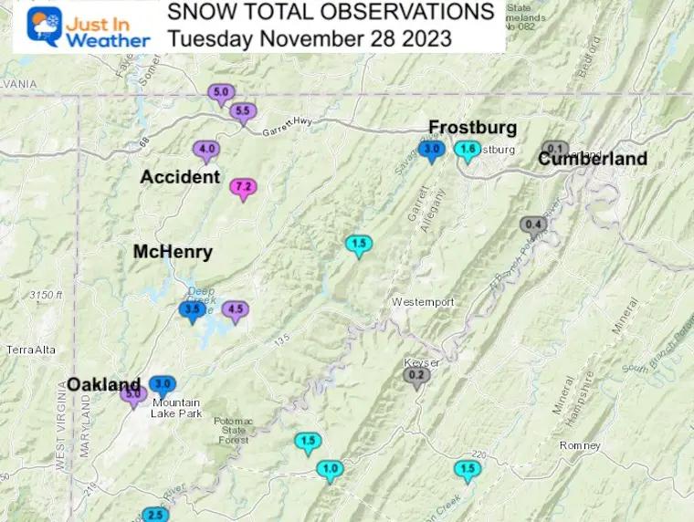
Western Maryland Snow Tuesday
The Lake Effect event reached the high mountains of Garrett County in Maryland. Here are the photos I received in the morning from my friend who lives between Oakland and McHenry.
Snow Reports
This map from The National Weather Service shows the spotter reports clustered west of Cumberland. That is often where a snow event like this is confined to…
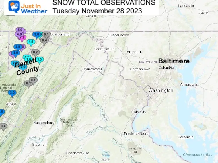
Closer Look
- 7.2” Accident
- 5” McHenry
- 5” Oakland
- 3” Frostburg
- Trace to 0.1” Cumberland
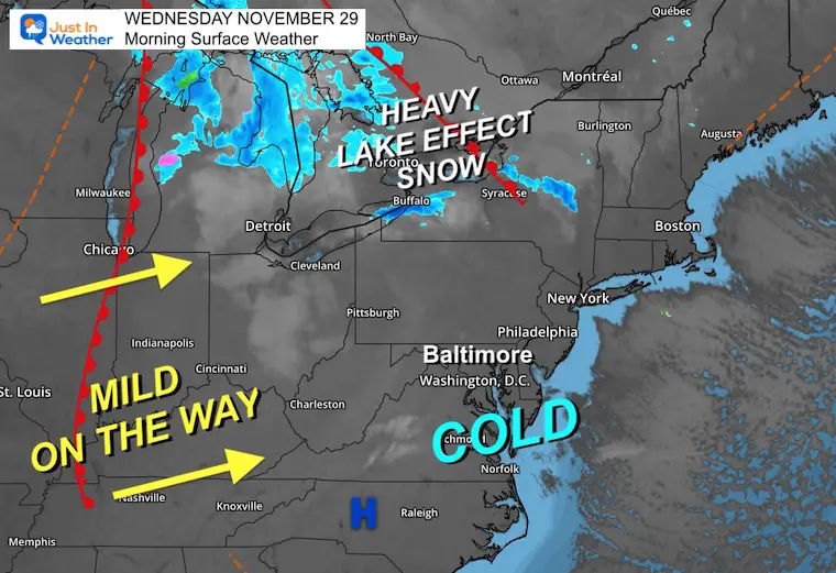
Morning Temperatures
The CORE OF THE COLD AIR is with us this morning. Note that the winds are light, but any breeze will make it feel like the TEENS.

Morning Surface Weather
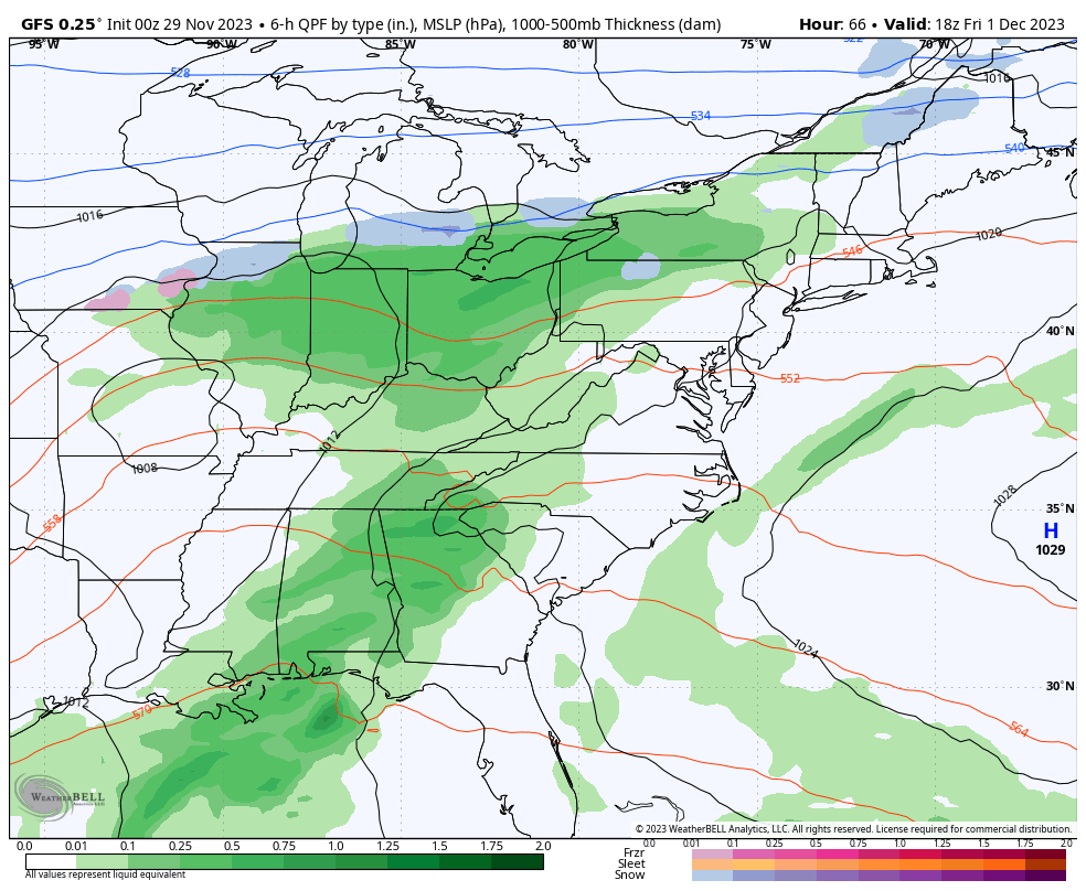
Today, we bottom out on the thermometer and then turn the corner. Lake Effect Snow across Michigan to New York has dumped FEET of snow in some places, and more will continue in the lucky spots near Buffalo and north of Syracuse.
A warm front marking the shift of winds in the Midwest will pivot our way and bring us seasonal air by tomorrow.
Snow Cam: Western Maryland
McHenry at Deep Creek Lake
This webcam is positioned at The Greene Turtle Deep Creek Lake and shows Wisp Resort, including a zoomed-in view of Squirrel Cage, The Face, the terrain park, Boulder, the mountain coaster, the tubing park, and a shot of McHenry Cove at Deep Creek Lake!
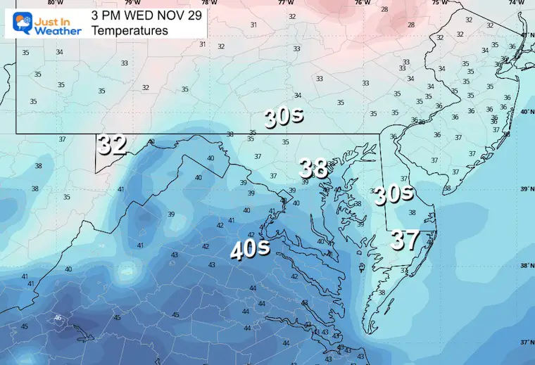
Afternoon Temperatures
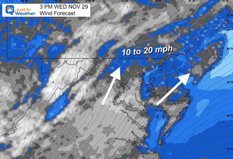
Wind Forecast at 3 PM
A shift in the wind direction AND lower speed.
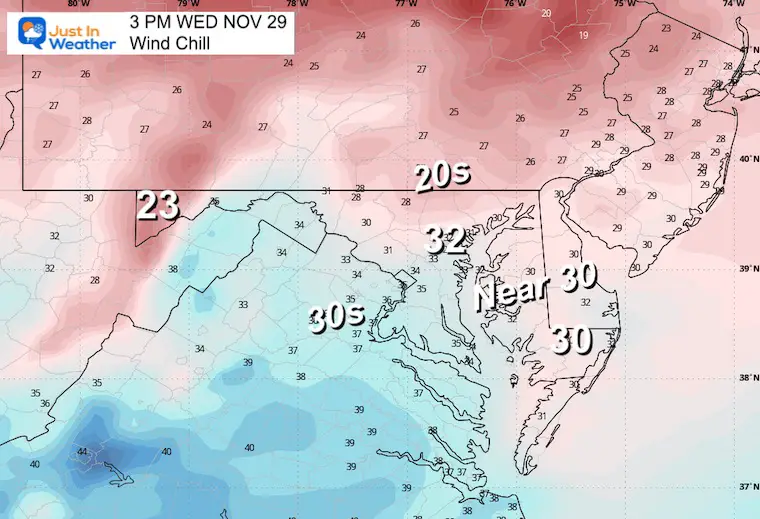
Wind Chill
CLIMATE DATA: Baltimore
TODAY November 29
Sunrise at 7:05 AM
Sunset at 4:45 PM
Normal Low in Baltimore: 33ºF
Record 13ºF in 1955
Normal High in Baltimore: 53ºF
Record 74ºF 1927
Winter Outlook Reports:
Winter Outlook Reports:

El Niño Winter Updates

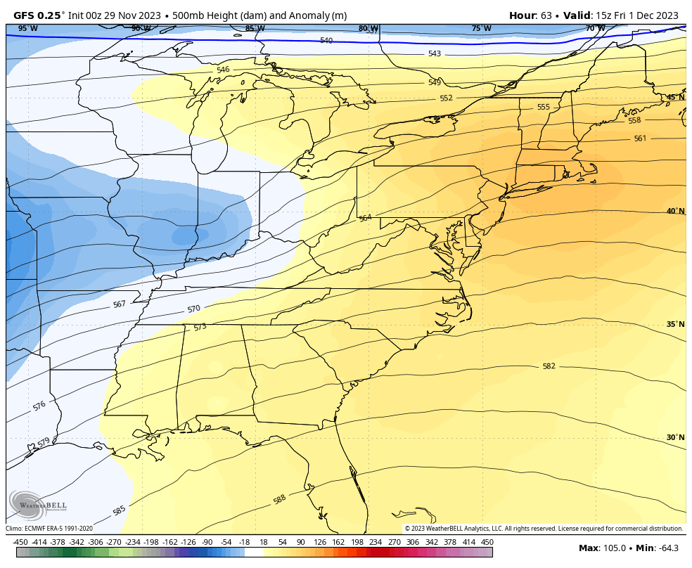
Computer Models Support East Coast Storm Track

El Niño Advisory
The latest NOAA report is confident in a Very Strong event. Possibly HISTORIC! This refers to the temperatures in the Pacific, with impacts on the US Winter Storm Track.

Winter Weather Folklore: Top 20 and more signals from nature for snow.
NOAA’s Winter Outlook 2024
Winter Outlook 2024 From Two Farmers Almanacs Return to Cold and Snow
Subscribe for eMail Alerts
Thursday
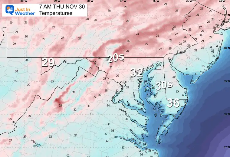
Morning Temperatures
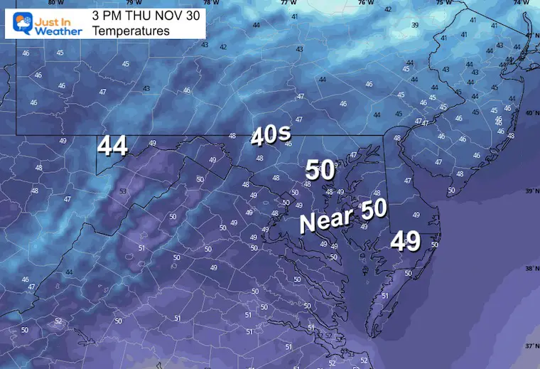
Afternoon Temperatures
Storm Simulation: Friday Morning To Tuesday Morning
Not a major storm, but the showers will build in from the south on Friday, and then another storm system will bring us rain on Sunday with showers into Monday.
Jet Stream Simulation: Friday Morning To Tuesday Morning
A mild weather pattern will set up for a few days. After the weekend storm, a surge of colder will return by Tuesday and last into the middle of next week.
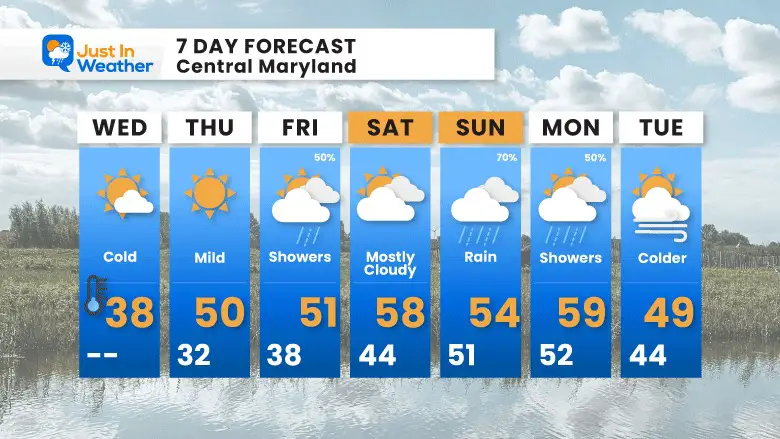
7 Day Forecast
We bounce back closer to normal tomorrow and remain mild into the weekend. The rain on Friday would be later in the day and evening. Then again on Sunday.
Explore More
Maryland Snow Climate History And Other Winter Pages

Faith in the Flakes Gear

STEM Assemblies/In School Fields Trips Are Back
Click to see more and ‘Book’ a visit to your school

Subscribe for eMail Alerts
Please share your thoughts and best weather pics/videos, or just keep in touch via social media
RESTATING MY MESSAGE ABOUT DYSLEXIA
I am aware there are some spelling and grammar typos and occasional other glitches. I take responsibility for my mistakes and even the computer glitches I may miss. I have made a few public statements over the years, but if you are new here, you may have missed it: I have dyslexia and found out during my second year at Cornell University. It didn’t stop me from getting my meteorology degree and being the first to get the AMS CBM in the Baltimore/Washington region. One of my professors told me that I had made it that far without knowing and to not let it be a crutch going forward. That was Mark Wysocki, and he was absolutely correct! I do miss my mistakes in my own proofreading. The autocorrect spell check on my computer sometimes does an injustice to make it worse. I also can make mistakes in forecasting. No one is perfect at predicting the future. All of the maps and information are accurate. The ‘wordy’ stuff can get sticky. There has been no editor who can check my work when I need it and have it ready to send out in a newsworthy timeline. Barbara Werner is a member of the web team that helps me maintain this site. She has taken it upon herself to edit typos when she is available. That could be AFTER you read this. I accept this and perhaps proves what you read is really from me… It’s part of my charm.
#FITF


