November 28, 2023
Tuesday Morning Update
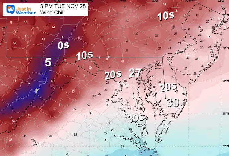
It surely feels like winter this morning! Strong cold winds AND even some flurries have reached central Maryland around metro Baltimore. More will continue through the day. This will be an afternoon that will focus on Wind Chills in the 20s, so dress accordingly.
We will stay in this cold air mass another day, then watch the next storm bring us a cool rain on Friday.
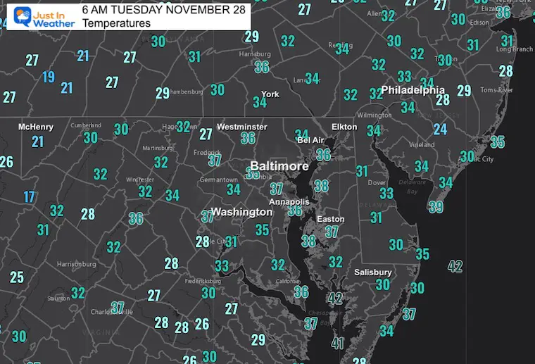
Morning Temperatures
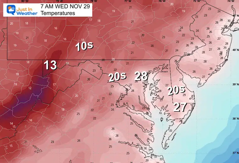
Most metro areas are in the 30s, so any flurries will not be sticking…. However, a few lucky ones may see a coating in spots.
There may be snow up to 2 inches on the roads in western Maryland and the mountains of West Virginia.
Strong winds will reach 30 mph gusts and keep wind chills in the 20s this afternoon.
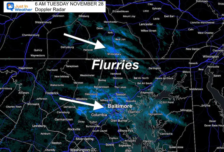
Radar Snapshot at 6 AM
Flurries and Snow Showers are scattered throughout metro Baltimore and southern PA.
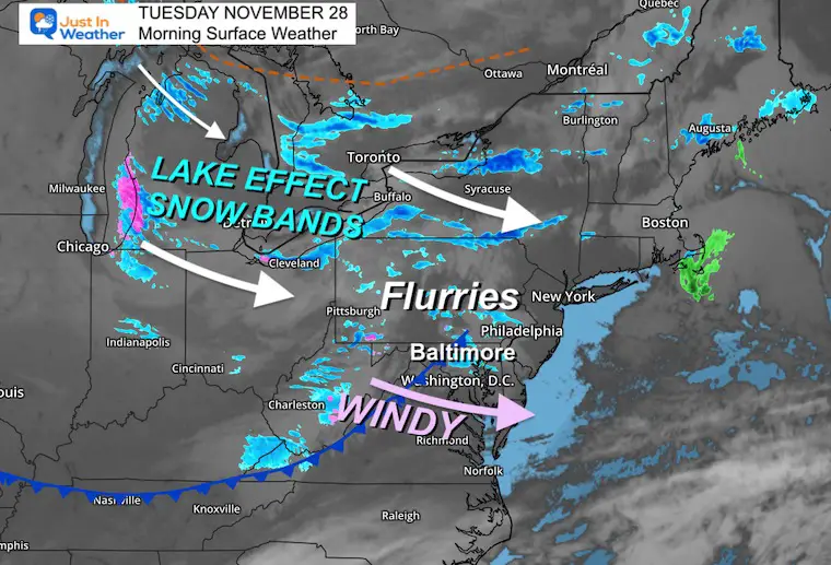
Morning Surface Weather
As the core of cold air builds in, there is support aloft to carry strong winds and some moisture. The Lake Effect snow bands are dumping heavy snow in the areas from Michigan to New York.
We have had some flurries into Central Maryland. More likely through the afternoon.
Western Maryland may get up to 2 inches of snow.
Snow Cam: Western Maryland
McHenry at Deep Creek Lake
This webcam is positioned at The Greene Turtle Deep Creek Lake and shows Wisp Resort, including a zoomed-in view of Squirrel Cage, The Face, the terrain park, Boulder, the mountain coaster, the tubing park, and a shot of McHenry Cove at Deep Creek Lake!
Radar Simulation: 7 AM to 4 PM
There are flurries projected on this product… I expect there will be more on the radar than we see here.
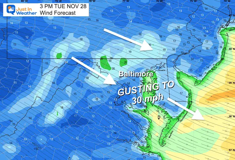
Wind Forecast 7 AM to 7 PM
Colder flow from the West and Northwest may gust from 20 to 30 mph at times, leading the surge of the cold core.
Snapshot at 3 PM
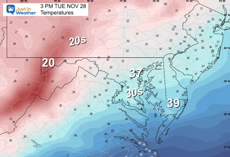
Afternoon Temperatures
Wind Chill
CLIMATE DATA: Baltimore
TODAY November 29
Sunrise at 7:04 AM
Sunset at 4:45 PM
Normal Low in Baltimore: 33ºF
Record 15ºF in 1951
Normal High in Baltimore: 53ºF
Record 73ºF 1990
Winter Outlook Reports:
Winter Outlook Reports:

El Niño Winter Updates

Computer Models Support East Coast Storm Track

El Niño Advisory
The latest NOAA report is confident in a Very Strong event. Possibly HISTORIC! This refers to the temperatures in the Pacific, with impacts on the US Winter Storm Track.

Winter Weather Folklore: Top 20 and more signals from nature for snow.
NOAA’s Winter Outlook 2024
Winter Outlook 2024 From Two Farmers Almanacs Return to Cold and Snow
Subscribe for eMail Alerts
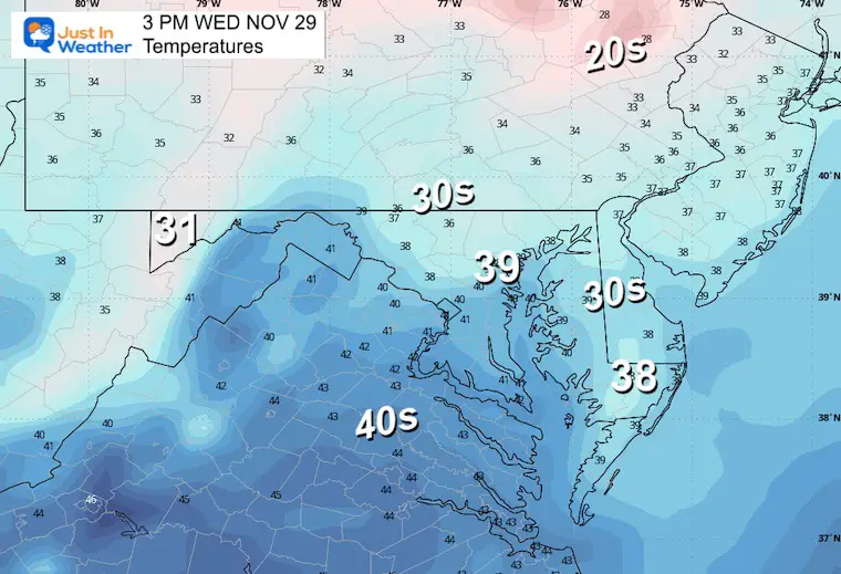
Wednesday
Morning Temperatures
Afternoon Temperatures
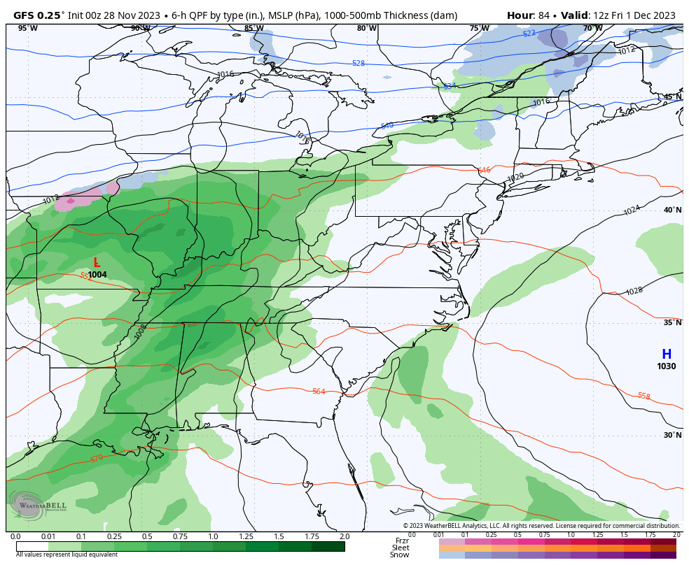
Storm Simulation: Friday Morning To Sunday Afternoon
We continue the pattern with Low Pressure on the coast and a cold front to the west linking up just after passing north of us.
At this time, there does seem to be a link up to allow for a wider area of rain, followed by another impulse or storm to end the weekend into early next week.
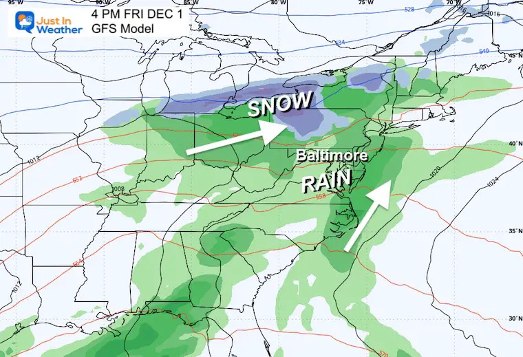
Snapshot: Friday Afternoon
The pattern does look a lot like the last two storm systems…. We can expect rain on Friday with snow farther north in PA and western New York.
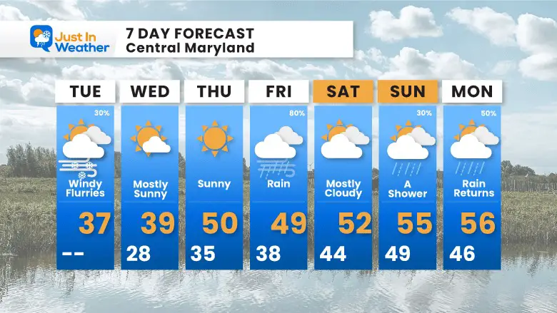
7 Day Forecast
We are in the cold core for two days, then modify as the next storm arrives with a chilly rain on Friday. There will be a few other disturbances on Sunday and Monday, with more chances for rain.
Explore More
Maryland Snow Climate History And Other Winter Pages

Faith in the Flakes Gear

STEM Assemblies/In School Fields Trips Are Back
Click to see more and ‘Book’ a visit to your school

Subscribe for eMail Alerts
Please share your thoughts and best weather pics/videos, or just keep in touch via social media
RESTATING MY MESSAGE ABOUT DYSLEXIA
I am aware there are some spelling and grammar typos and occasional other glitches. I take responsibility for my mistakes and even the computer glitches I may miss. I have made a few public statements over the years, but if you are new here, you may have missed it: I have dyslexia and found out during my second year at Cornell University. It didn’t stop me from getting my meteorology degree and being the first to get the AMS CBM in the Baltimore/Washington region. One of my professors told me that I had made it that far without knowing and to not let it be a crutch going forward. That was Mark Wysocki, and he was absolutely correct! I do miss my mistakes in my own proofreading. The autocorrect spell check on my computer sometimes does an injustice to make it worse. I also can make mistakes in forecasting. No one is perfect at predicting the future. All of the maps and information are accurate. The ‘wordy’ stuff can get sticky. There has been no editor who can check my work when I need it and have it ready to send out in a newsworthy timeline. Barbara Werner is a member of the web team that helps me maintain this site. She has taken it upon herself to edit typos when she is available. That could be AFTER you read this. I accept this and perhaps proves what you read is really from me… It’s part of my charm.
#FITF


